

San Bernardino County Sheriff's Department
Encyclopedia
The San Bernardino County Sheriff's Department (SBSD) serves San Bernardino County, California
, which is geographically the largest county in the lower 48 states. SBSD provides law enforcement services to the unincorporated areas of the county and contract law enforcement services to 14 of the county's cities, serving a total of 1,029,466 of the county's 2 million residents. The department also operates the county jail system, provides marshal services for the county superior courts, and has numerous other specialized divisions to serve the citizens of San Bernardino County.
unit known as the San Bernardino Rangers was organized under the command of Captain Andrew Lytle to aid the Sheriff in suppressing raids by Indians and the gangs of outlaws like the Flores-Daniel Gang that plagued the County. Sheriff Clift left for Utah
that year and was followed in office by Joseph Bridger who held the office until 1859.
Valentine Herring was next as Sheriff until the fall of 1860. Herring was replaced by Charles W. Piercey who held the office until he resigned in October 1860 to run for the State Assembly. Anson Van Leuvan served as Sheriff from 1860 to 1862. He had difficulties enforcing the law in Belleville
and the other boom towns of the Holcomb Valley
gold rush and with the turbulence caused in the County by the secession crisis and the beginning of the American Civil War
. Eli M. Smith elected in the fall of 1861, was known for his pursuit of a gang of horse thieves who had been operating in the county for several months stealing horses made precious by the wartime need for horseflesh. On one occasion Sheriff Smith rode into an outlaw camp, recovering a herd of stolen horses and arresting three thieves. By the end of his term in office he had convicted 18 men of horse theft and sent them to prison. Sheriff Benjamin F. Mathews served from 1863 to 1864.
George T. Fulgham
was Sheriff from 1864 to 1869. In September, 1865 the outlaw James Henry
of the Mason Henry Gang
and his gang of rustlers, robbers and murderers were in the county, camped out near San Bernardino. Sheriff George T. Fulgham
and his posse led by John Rogers (a gang member sent to town to obtain provisions and captured after drunken boasting), found and surprised Henry camped in Railroad Canyon
, (then called San Jacinto Canyon), about twenty-five miles from town. At sunrise on September 14, 1865, the posse
approached cautiously but Henry awoke and fired three shots, striking one posse member in the foot. Henry died in a hail of gunfire, sustaining 57 wounds. His corpse was taken back to town, photographed and his body was displayed to the public in Old West fashion.
Some of the other men holding the office of Sheriff in the early years were, Newton Noble (1869–1873), J. C Curry (1873–1877), William Davies (1877–1879), John C. King (1879–1882), J. B. Burkhart (1882–1884), Nelson G. Gill (1884–1885), Edwin Chidsey Seymour (1888–1892), James P. Booth 1892-1894), Charles A. Rouse (1894–1895), John C. Ralphs (1902–1915), J. L. McMinn (1915–1918).
, who is the second in command of the department. Beneath the Undersheriff are two Assistant Sheriff's. One Assistant Sheriff is in charge of Operations and the other is in charge of Support. SBSD is further organized into seven bureau's. Each bureau is commanded by a Deputy Chief. The bureau's are:
, Pomona Valley
, Cucamonga Valley
, and the communities in the San Bernardino Mountains
. This area also operates a Type I Jail booking facility.
portion of the county . The deputies at many of these stations operate in remote areas. This area also operates 3 of SBSD's Type I Jail booking facilities.
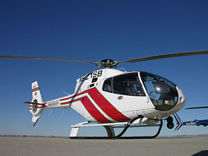
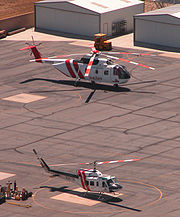 Aviation provides services including general law enforcement support, surveillance, fire suppression, medical transport, and search and rescue duties. It operates the following aircraft:
San Bernardino County, California
San Bernardino County is a county in the U.S. state of California. As of the 2010 census, the population was 2,035,210, up from 1,709,434 as of the 2000 census...
, which is geographically the largest county in the lower 48 states. SBSD provides law enforcement services to the unincorporated areas of the county and contract law enforcement services to 14 of the county's cities, serving a total of 1,029,466 of the county's 2 million residents. The department also operates the county jail system, provides marshal services for the county superior courts, and has numerous other specialized divisions to serve the citizens of San Bernardino County.
History
When San Bernardino County was established in 1853, its first Sheriff was a Mormon, Robert Clift, who served until 1857. On January 12, 1856, a volunteer militiaMilitia
The term militia is commonly used today to refer to a military force composed of ordinary citizens to provide defense, emergency law enforcement, or paramilitary service, in times of emergency without being paid a regular salary or committed to a fixed term of service. It is a polyseme with...
unit known as the San Bernardino Rangers was organized under the command of Captain Andrew Lytle to aid the Sheriff in suppressing raids by Indians and the gangs of outlaws like the Flores-Daniel Gang that plagued the County. Sheriff Clift left for Utah
Utah
Utah is a state in the Western United States. It was the 45th state to join the Union, on January 4, 1896. Approximately 80% of Utah's 2,763,885 people live along the Wasatch Front, centering on Salt Lake City. This leaves vast expanses of the state nearly uninhabited, making the population the...
that year and was followed in office by Joseph Bridger who held the office until 1859.
Valentine Herring was next as Sheriff until the fall of 1860. Herring was replaced by Charles W. Piercey who held the office until he resigned in October 1860 to run for the State Assembly. Anson Van Leuvan served as Sheriff from 1860 to 1862. He had difficulties enforcing the law in Belleville
Belleville, California
Belleville, California was a gold mining boomtown in the San Bernardino Mountains of San Bernardino County, California. It grew up rapidly following the discovery of gold by William F. Holcomb in Holcomb Valley early in 1860. Belleville was named after Belle, the first child born in the new town...
and the other boom towns of the Holcomb Valley
Holcomb Valley
Holcomb Valley, located in the San Bernardino Mountains about five miles north of Big Bear Lake, was the site of the most gold mined in Southern California. It was named after William F. Holcomb, who discovered gold there in 1860. That year started the largest gold rush in Southern California to...
gold rush and with the turbulence caused in the County by the secession crisis and the beginning of the American Civil War
American Civil War
The American Civil War was a civil war fought in the United States of America. In response to the election of Abraham Lincoln as President of the United States, 11 southern slave states declared their secession from the United States and formed the Confederate States of America ; the other 25...
. Eli M. Smith elected in the fall of 1861, was known for his pursuit of a gang of horse thieves who had been operating in the county for several months stealing horses made precious by the wartime need for horseflesh. On one occasion Sheriff Smith rode into an outlaw camp, recovering a herd of stolen horses and arresting three thieves. By the end of his term in office he had convicted 18 men of horse theft and sent them to prison. Sheriff Benjamin F. Mathews served from 1863 to 1864.
George T. Fulgham
George T. Fulgham
George T. Fulgham, Sheriff of San Bernardino County, California from 1864-1866. Led the posse that killed Jim Henry of the Mason Henry Gang in San Jacinto Canyon on September 14, 1865.-References:...
was Sheriff from 1864 to 1869. In September, 1865 the outlaw James Henry
Tom McCauley
Tom McCauley, better known by his alias as James Henry or Jim Henry , was one of the many California Gold Rush criminals in Tuolumne County convicted of murder with his brother in 1857 and imprisoned for ten years...
of the Mason Henry Gang
Mason Henry Gang
Mason Henry Gang 1864-1865, a bandit gang that posed as Confederate partisan rangers but acted as outlaws, committing robberies, thefts and murders in the southern San Joaquin Valley, Santa Cruz County, Monterey County, Santa Clara County, and in counties of Southern California.- Mason and Henry as...
and his gang of rustlers, robbers and murderers were in the county, camped out near San Bernardino. Sheriff George T. Fulgham
George T. Fulgham
George T. Fulgham, Sheriff of San Bernardino County, California from 1864-1866. Led the posse that killed Jim Henry of the Mason Henry Gang in San Jacinto Canyon on September 14, 1865.-References:...
and his posse led by John Rogers (a gang member sent to town to obtain provisions and captured after drunken boasting), found and surprised Henry camped in Railroad Canyon
Railroad Canyon
Railroad Canyon, also known as San Jacinto Canyon, Cottonwood Canyon, and Annie Orton Canyon, lies along the course of the San Jacinto River at the point where the river passes south through the hills from Perris, California, through Canyon Lake, California, then west to Lake Elsinore, California...
, (then called San Jacinto Canyon), about twenty-five miles from town. At sunrise on September 14, 1865, the posse
Posse
Posse may refer to:* Posse comitatus , a group of men assembled to assist in law enforcement* Posse , starring Kirk Douglas* Posse , starring Mario van Peebles...
approached cautiously but Henry awoke and fired three shots, striking one posse member in the foot. Henry died in a hail of gunfire, sustaining 57 wounds. His corpse was taken back to town, photographed and his body was displayed to the public in Old West fashion.
Some of the other men holding the office of Sheriff in the early years were, Newton Noble (1869–1873), J. C Curry (1873–1877), William Davies (1877–1879), John C. King (1879–1882), J. B. Burkhart (1882–1884), Nelson G. Gill (1884–1885), Edwin Chidsey Seymour (1888–1892), James P. Booth 1892-1894), Charles A. Rouse (1894–1895), John C. Ralphs (1902–1915), J. L. McMinn (1915–1918).
Organizational structure
The current Sheriff of San Bernardino County is Sheriff Rod Hoops, who replaced Gary Penrod who retired on January 31, 2009. Serving below the Sheriff is the UndersheriffUndersheriff
An Undersheriff is an office derived from ancient British practice and still extant in, among other places, the United Kingdom and the United States, though somewhat different forms.-United States:...
, who is the second in command of the department. Beneath the Undersheriff are two Assistant Sheriff's. One Assistant Sheriff is in charge of Operations and the other is in charge of Support. SBSD is further organized into seven bureau's. Each bureau is commanded by a Deputy Chief. The bureau's are:
Administrative Services Bureau
This bureau operates the following divisions:- Emergency Services- Aviation and Volunteer Forces.
- Aviation provides services including general law enforcement support, surveillance, fire suppression, medical transport, and search and rescue duties. It operates 6 Astar B-3 Eurocopters, 1 Mcdonnell Douglas MD500E, 2 Bell UH-1H Super Huey II's, 1 Bell 212, 1 Sikorsky H-3, 1 Aero Commander Grand Reconnaissance, and 1 Cessna 182. Deemed the third largest, non-military air force in the world.
- Volunteer Forces supports the 2,000 volunteers within 112 units in SBSD. These units include Reserve Deputies, Explorer Scouts, and Search and Rescue members. These people, working for free, donate and average of 500,000 hours a year to the county .
- Employee Resources- The personnel in this division participate in recruiting, conduct background investigations on potential employees, are responsible for payroll and benefits, and oversee the issuance of Concealed Weapons Permits.
- Training- This includes the Basic Academy, the Emergency Vehicle Operations Center, the Advanced Officer Training Center, and Firearms Training Center.
- SBSD operates its own intensive, structured format, on-site post certified basic academy in conjunction with San Bernardino Valley College. The program is 23 weeks in length.
- The Emergency Vehicle Operations Center (EVOC) provides driving training to entry level and in-service officers.
- The Advanced Officer Training Center provides advanced law enforcement courses in a variety of topics to both sworn and non-sworn personnel.
- The Firearms Training Center provides firearms training to SBSD and numerous other agencies in Southern California. Additionally every trimester SBSD deputies as well as several other county agencies conduct firearms qualifications, perishable skills, and other important training through the center's Range/Use of Force Unit.
Detentions and Corrections Bureau
SBSD operates a total of 9 jail facilities throughout the county. The average daily inmate population is 5,600. In 2006, 107,606 people were booked into these jails. The bureau operates the following Type-II jails that are used for long term housing:- West Valley Detention Center - This is SBSD's main jail facility and opened in June, 1991. It is located in Rancho CucamongaRancho Cucamonga, CaliforniaRancho Cucamonga is a suburban city in San Bernardino County, California. As of the 2010 census, the city had a population of 165,269, up from 127,743 at the 2000 census. L. Dennis Michael was elected as Mayor on November 2, 2010. Jack Lam is the City Manager...
. It is used primarily to house pre-sentenced county inmates, and is capable of housing 3,291 inmates daily.
- Central Detention Center - This facility served as SBSD's main jail since its opening in 1971. It is located in downtown San Bernardino. It is primarily used to house pre-sentenced county inmates and federal inmates, and averages a daily population of 930. The US Marshal Service also uses the facility as the west coast hub for transporting and housing federal inmates.
- Glen Helen Rehabilitation Center - This facility primarily serves as housing for inmates sentenced to county jail. It also houses some pre-sentence inmates. It averages a population of 1020 inmates daily. It is located in Devore, at the north end of San Bernardino.
- Adelanto Detention Center - This is SBSD's newest jail facility, which opened in January 2006. It is used to house approximately 700 pre-sentence inmates per day.
- Victor Valley Jail- This jail facility is a Type-1 jail run by the Adelanto Detention Center. It is located at the Victorville Superior Court complex.
- Transportation Detail - This detail operates 12 buses, 13 vans, and 2 cars to transport an average of 286,000 yearly, mostly to court appearances. In 2006, the detail accumulated 934000 miles (1,503,123.6 km).
Patrol Operations Region I
This bureau provides law enforcement services to the densely populated southwest corner of the county, which includes parts of the San Bernardino ValleySan Bernardino Valley
The San Bernardino Valley is a valley in Southern California. It lies at the south base of the Transverse Ranges. It is bordered on the north by the eastern San Gabriel Mountains and San Bernardino Mountains, on the east by the San Jacinto Mountains, and on the south and west by the Santa Ana...
, Pomona Valley
Pomona Valley
The Pomona Valley, located between the San Gabriel Valley and Cucamonga Valley in Southern California, straddles the border between Los Angeles County and San Bernardino County. Back on March 1, 1893 the California Assembly voted 54-14 for a new county to form in the region, San Antonio County,...
, Cucamonga Valley
Cucamonga Valley
The Cucamonga Valley is a region between the Los Angeles and San Bernardino areas, in San Bernardino County and Riverside County, of California, United States. It is located east of the Pomona Valley and it is a major site of wine production and is the location of the Cucamonga Valley AVA, a...
, and the communities in the San Bernardino Mountains
San Bernardino Mountains
The San Bernardino Mountains are a short transverse mountain range north and east of San Bernardino in Southern California in the United States. The mountains run for approximately 60 miles east-west on the southern edge of the Mojave Desert in southwestern San Bernardino County, north of the...
. This area also operates a Type I Jail booking facility.
- Big Bear Station - Provides law enforcement services to the City of Big Bear Lake, CaliforniaBig Bear Lake, CaliforniaBig Bear Lake is a city in San Bernardino County, California along the south shore of Big Bear Lake, located northeast of the city of San Bernardino. The population was 5,019 at the 2010 census, down from 5,438 at the 2000 census...
, as well as the unincorporated areas of Big Bear CityBig Bear City, CaliforniaBig Bear City is an unincorporated, census-designated place in San Bernardino County, California immediately east of Big Bear Lake. The population was 12,304 at the 2010 census, up from 5,779 at the 2000 census...
, SugarloafSugarloaf, CaliforniaSugarloaf is an unincorporated residential area less than a mile south of Big Bear City and 8 miles from the eastern tip of Big Bear Lake in the San Bernardino Mountains of San Bernardino County, California. The area is primarily residential with a convenience store and a bar located at the center...
, Baldwin LakeBaldwin Lake, CaliforniaBaldwin Lake is a natural, intermittent, alkali lake in a valley of the San Bernardino Mountains, in San Bernardino County, California. The depth of Baldwin Lake's lowest point is approximately 25 feet . At its widest, the lake is more than a mile across...
and throughout the Big Bear Valley.- Big Bear Jail - This is a Type I Jail used for booking and court holding for the Big Bear Superior Court. It is located at the Big Bear Station.
- Central Station - This station provides law enforcement services to the unincorporated areas around San Bernardino as well as contract law enforcement to the cities of Loma LindaLoma Linda, CaliforniaLoma Linda is a city in San Bernardino County, California, United States, that was incorporated in 1970. The population was 23,261 at the 2010 census, up from 18,681 at the 2000 census...
, Grand TerraceGrand Terrace, CaliforniaGrand Terrace is a city in San Bernardino County, California, United States. The population was 12,040 at the 2010 census, up from 11,626 at the 2000 census. Grand Terrace is located between the cities of Riverside and San Bernardino along the I-215 corridor...
, and the San Manuel Indian Reservation. The unincorporated areas include MuscoyMuscoy, CaliforniaMuscoy is a census-designated place in San Bernardino County, California, United States. The population was 10,644 at the 2010 census, up from 8,919 at the 2000 census. Muscoy shares zip code 92407 with northwest San Bernardino, California's Verdemont neighborhood, Devore Heights, and Arrowhead...
, DevoreDevore, CaliforniaDevore is a neighborhood in the city of San Bernardino, California. It is located near the northern junction of Interstate 15 and Interstate 215. The area is just outside the boundaries of the San Bernardino National Forest; nearby cities/town centers include Universitytown, Fontana, and Rialto...
, as well as parts of San Bernardino, Rialto, and Colton.
- Chino Hills Station - This station provides contract law enforcement exclusively to the City of Chino HillsChino Hills, CaliforniaChino Hills is a Los Angeles suburb located in the southwestern corner of San Bernardino County, California, United States. The city borders Los Angeles County on its northwest side, Orange County to its south, and Riverside County to its southeast...
.
- Fontana Station - Provides law enforcement services to the unincorporated areas around the City of FontanaFontana, CaliforniaFontana is a city of 196,069 residents in San Bernardino County, California. Founded in 1913, it remained essentially rural until World War II, when entrepreneur Henry J. Kaiser built a large steel mill in the area...
, including BloomingtonBloomington, CaliforniaBloomington is an unincorporated census-designated place in San Bernardino County, California, United States. The population was 23,851 at the 2010 census, up from 19,318 at the 2000 census....
, Lytle CreekLytle Creek, CaliforniaLytle Creek is a census-designated place in San Bernardino County. It is about northwest of downtown San Bernardino and 10 miles from the cities of Fontana and Rialto. This small remote community is located in a large southeast-trending canyon on the eastern portion of the San GabrielMountains...
, San Antonio HeightsSan Antonio Heights, CaliforniaSan Antonio Heights is a census-designated place in San Bernardino County, California, United States. The population was 3,371 at the 2010 census, up from 3,122 at the 2000 census.-Geography:...
, the Auto Club Speedway, and unincorporated areas around the incorporated cities of UplandUpland, CaliforniaUpland is a city in San Bernardino County, California, located at an elevation of 1,242 feet . As of the 2010 census, the city had a population of 73,732, up from 68,393 at the 2000 census. It was incorporated on May 15, 1906, after previously being named North Ontario.-History and culture:Upland...
, Rancho CucamongaRancho Cucamonga, CaliforniaRancho Cucamonga is a suburban city in San Bernardino County, California. As of the 2010 census, the city had a population of 165,269, up from 127,743 at the 2000 census. L. Dennis Michael was elected as Mayor on November 2, 2010. Jack Lam is the City Manager...
and OntarioOntario, CaliforniaOntario is a city located in San Bernardino County, California, United States, 35 miles east of downtown Los Angeles. Located in the western part of the Inland Empire region, it lies just east of the Los Angeles county line and is part of the Greater Los Angeles Area...
.
- Highland Police Department - This station provides contract law enforcement services exclusively to the City of Highland, CaliforniaHighland, CaliforniaHighland is a city in San Bernardino County, California, United States. The population in 2010 was 53,104, up from 44,605 at the 2000 census...
.
- Rancho Cucamonga Police Department – This station provides contract law enforcement exclusively to the City of Rancho Cucamonga, CaliforniaRancho Cucamonga, CaliforniaRancho Cucamonga is a suburban city in San Bernardino County, California. As of the 2010 census, the city had a population of 165,269, up from 127,743 at the 2000 census. L. Dennis Michael was elected as Mayor on November 2, 2010. Jack Lam is the City Manager...
.
- Twin Peaks Station – Serves the unincorporated areas in the central portion of the San Bernardino Mountains including the communities of Lake ArrowheadLake Arrowhead, CaliforniaLake Arrowhead is an unincorporated community and a census-designated place in the San Bernardino Mountains of San Bernardino County, California, within the San Bernardino National Forest, adjacent to Lake Arrowhead Reservoir...
, CrestlineCrestline, CaliforniaCrestline is a census-designated place in the San Bernardino Mountains of San Bernardino County, California, USA. The population was 10,770 at the 2010 census, up from 10,218 at the 2000 census.-Geography:Crestline is located at ....
, Running SpringsRunning Springs, CaliforniaRunning Springs is a census-designated place in San Bernardino County, California, United States. The population was 4,862 at the 2010 census, down from 5,125 at the 2000 census.-Geography:Running Springs is located at ....
, and Twin PeaksTwin Peaks, CaliforniaTwin Peaks is an unincorporated community in San Bernardino County, California, United States. Twin Peaks is located on California State Route 189 west-southwest of Lake Arrowhead. Twin Peaks has a post office with ZIP code 92391, which opened in 1916....
.
- Yucaipa Station – Provides law enforcement services to the City of YucaipaYucaipa, CaliforniaYucaipa is a city located east of San Bernardino, in San Bernardino County, California, United States. The population was 51,367 at the 2010 census, up from 41,207 at the 2000 census...
as well as the unincorporated areas include MentoneMentone, CaliforniaMentone is a census-designated place in San Bernardino County, California, United States. The population was 8,720 at the 2010 census, up from 7,803 at the 2000 census. It is located at ....
, Oak Glen, Mountain Home Village, Angelus OaksAngelus Oaks, CaliforniaAngelus Oaks is an unincorporated town in San Bernardino County, California, USA, and has a population of 289. It is located north of Mentone, California on State Highway 38. Its downtown consists of a general store , a restaurant, a post office , a real estate office, and a United States Forest...
, Forest FallsForest Falls, CaliforniaForest Falls is an unincorporated community in San Bernardino County, California, due east of Los Angeles. The community has a population of 943 and contains 712 houses...
, Barton Flats. It also operates a resident deputy sub-station in Barton Flats.
Patrol Operations Region II
This bureau provides law enforcement services to the large Mojave DesertMojave Desert
The Mojave Desert occupies a significant portion of southeastern California and smaller parts of central California, southern Nevada, southwestern Utah and northwestern Arizona, in the United States...
portion of the county . The deputies at many of these stations operate in remote areas. This area also operates 3 of SBSD's Type I Jail booking facilities.
- Apple Valley Police Department - This station provides contract law enforcement exclusively to the Town of Apple ValleyApple Valley, California-Climate:*On average, the warmest month is July.*The highest recorded temperature was in 2002.*On average, the coolest month is December.*The lowest recorded temperature was in 1949.*The most precipitation on average occurs in February.-History:...
.
- Barstow Station - Provides law enforcement services the unincorporated areas around the City of BarstowBarstow, CaliforniaBarstow is a city in San Bernardino County, California, United States. The population was 22,639 at the 2010 census, up from 21,119 at the 2000 census. Barstow is located north of San Bernardino....
. This area includes unincorporated Barstow, LenwoodLenwood, CaliforniaLenwood is a census-designated place in San Bernardino County, California, United States. The population was 3,543 at the 2010 census, up from 3,222 at the 2000 census...
, Grandview, HinkleyHinkley, CaliforniaHinkley is an unincorporated community in the Mojave Desert in California, U.S., northwest of Barstow, east of Mojave, and north of Victorville. It sits just north of California State Highway 58....
, YermoYermo, CaliforniaYermo is a town in San Bernardino County, California. Its name is derived from the Spanish word for wilderness. It is located 13 miles east of Barstow in the Mojave Desert on Interstate 15, just south of the Calico Mountains...
, DaggettDaggett, CaliforniaDaggett is an unincorporated town located in San Bernardino County, California in the United States. The town is located on Interstate 40 ten miles East of Barstow. The town has a population of about 200. The ZIP code is 92327 and the community is inside area code 760.-History:The town was...
, Newberry SpringsNewberry Springs, CaliforniaNewberry Springs is an unincorporated area in the western Mojave Desert of Southern California, located at the foot of the Newberry Mountains in San Bernardino County, California, USA...
, TronaTrona, CaliforniaTrona is an unincorporated community in San Bernardino County, California. In 2000 it had a population of 2,742. Trona is at the western edge of Searles Lake, a dry lake bed in Searles Valley, southwest of Death Valley. The town takes its name from the mineral trona, abundant in the lakebed.It is...
, BakerBaker, CaliforniaBaker is a census-designated place located in San Bernardino County, California, USA. As of the 2010 census, the town had a total population of 735.Baker was founded as a station on the Tonopah and Tidewater Railroad in 1908,...
, Red MountainRed Mountain, CaliforniaRed Mountain, formerly known as Osdick, is an unincorporated community in San Bernardino County, California, United States.Red Mountain is south-southwest of Trona, part of the mining district of Randsburg, California and Johannesburg, California....
, Kramer JunctionKramer Junction, CaliforniaKramer Junction is a small community in the Mojave Desert at the intersection of U.S. Route 395 and State Route 58.Solar Energy Generating Systems sites SEGS III-VII are located less than a mile to the northwest....
, HelendaleHelendale, CaliforniaHelendale is an unincorporated community located in San Bernardino County, California, on historic Route 66 west of the Mojave Freeway, between Barstow and Victorville, in the Victor Valley. It includes the Helendale resort community of Silver Lakes.-History:...
, Fort Irwin, and LudlowLudlow, CaliforniaLudlow is a small town in the Mojave Desert on Interstate 40, located in San Bernardino County, California, United States. The older remains of the ghost town are along historic Route 66.-Geography:...
. This station also has resident deputy sub-stations in TronaTrona, CaliforniaTrona is an unincorporated community in San Bernardino County, California. In 2000 it had a population of 2,742. Trona is at the western edge of Searles Lake, a dry lake bed in Searles Valley, southwest of Death Valley. The town takes its name from the mineral trona, abundant in the lakebed.It is...
and BakerBaker, CaliforniaBaker is a census-designated place located in San Bernardino County, California, USA. As of the 2010 census, the town had a total population of 735.Baker was founded as a station on the Tonopah and Tidewater Railroad in 1908,...
. The Barstow Station covers 9219 square miles (23,877.1 km²) and has the largest patrol area in the county.- Barstow Jail - This Type I Jail is used as a booking facility for the Barstow area and court holding for the Barstow Superior Court. It is located at the Barstow Station.
- Colorado River Station - Serves the unincorporated areas at the east end of the county near Needles and provides contract law enforcement to the city of NeedlesNeedles, CaliforniaNeedles is a city located in the Mojave Desert on the western banks of the Colorado River in San Bernardino County, California. It is located in the Mohave Valley, which straddles the California–Arizona border. The city is accessible via Interstate 40 and U.S. Route 95...
. The areas include Big RiverBig River, CaliforniaBig River is a census-designated place in San Bernardino County, California, United States. The population was 1,327 at the 2010 census, up from 1,266 at the 2000 census.-Geography:...
, Parker DamParker Dam, CaliforniaParker Dam is an unincorporated community in San Bernardino County, California, United States. Parker Dam is located along the Colorado River across from Arizona east-northeast of Vidal. Parker Dam has a post office with ZIP code 92267. The post office opened in 1935 and closed briefly between...
, and Havasu Landing. This station has a resident deputy sub-station in Havasu Landing. It also operates a Marine Enforcement unit that patrols San Bernardino County's portion of the Colorado River.- Needles Jail - This Type I Jail is used as a booking facility for the Needles area and court holding for the Needles Superior Court. It is located at the Colorado River Station.
- Hesperia Police Department- This station provides law enforcement services only for the City of HesperiaHesperia, CaliforniaHesperia is a city in San Bernardino County, California, United States. It is located in the Mojave Desert north of San Bernardino. The locals refer to the surrounding area as the High Desert...
.
- Morongo Basin Station - Serves the unincorporated areas of the Morongo Basin and provides contract law enforcement services to the Cities of Twentynine PalmsTwentynine Palms, CaliforniaTwentynine Palms is a city in San Bernardino County, California, United States. It was previously called Twenty-Nine Palms...
and Yucca ValleyYucca Valley, CaliforniaYucca Valley is an incorporated town located in San Bernardino County, California, United States. The population was 20,700 at the 2010 census, up from 16,865 at the 2000 census...
. The unincorporated areas includes the Morongo ValleyMorongo Valley, CaliforniaMorongo Valley is a census-designated place in San Bernardino County, California, United States. The population was 3,552 at the 2010 census, up from 1,929 at the 2000 census.-Geography and climate:...
, LandersLanders, CaliforniaLanders is an unincorporated community in San Bernardino County, California. The town lies in the Homestead Valley of the Mojave Desert, northeast of Flamingo Heights. The closest large towns are Yucca Valley and Joshua Tree. The town has its own small airport, Landers Airport.Near Landers is Giant...
, Johnson ValleyJohnson Valley, California- Location :Johnson Valley is a small unincorporated community in San Bernardino County in Southern California between the Victor Valley and Morongo Basin areas of the High Desert region of California. It is located south of Highway 247 in the Mojave Desert northwest of Yucca Valley...
, Joshua TreeJoshua Tree, CaliforniaJoshua Tree is a census-designated place in San Bernardino County, California, United States. The population was 7,414 at the 2010 census, up from 4,207 at the 2000 census.-Geography:Joshua Tree is located in the Mojave Desert at ....
, Wonder Valley, PioneertownPioneertown, CaliforniaPioneertown, California is an unincorporated village in the Morongo Basin region of Southern California's Inland Empire Metropolitan Area. It is located approximately 56 miles east of San Bernardino.-History:...
, AmboyAmboy, CaliforniaAmboy is an unincorporated town in San Bernardino County, in California's Mojave Desert, west of Needles and east of Ludlow on historic Route 66. It is roughly 60 miles northeast of Twentynine Palms.-Geography:...
, CadizCadiz, CaliforniaCadiz is a small unincorporated community in the Mojave Desert in San Bernardino County, California. It is located just south of the Marble Mountains near the National Trails Highway. Cadiz is home to a former railroad stop, and is situated at 34° 31' 12" North latitude and 115° 30' 43" West...
, and Flamingo Heights.- Morongo Jail - This Type I Jail is used as a booking facility for the Morongo Basin and court holding for the Joshua Tree Superior Court. It is located at the Morongo Basin Station.
- Victor Valley Station - Provides law enforcement to the unincorporated areas of the Victor Valley and the City of AdelantoAdelanto, CaliforniaAdelanto is a city in San Bernardino County, California about northwest of Victorville. The population was 31,765 at the 2010 census, up from 18,130 at the 2000 census.-Name:...
. This area includes HelendaleHelendale, CaliforniaHelendale is an unincorporated community located in San Bernardino County, California, on historic Route 66 west of the Mojave Freeway, between Barstow and Victorville, in the Victor Valley. It includes the Helendale resort community of Silver Lakes.-History:...
, Oro GrandeOro Grande, CaliforniaOro Grande is an unincorporated community in the Mojave Desert of San Bernardino County, California, United States. It lies on the city boundary of Victorville and Adelanto. It is at elevation in Victor Valley north of the San Bernardino mountain range. It is located on old Route 66 near...
, Mountain View AcresMountain View Acres, CaliforniaMountain View Acres is a census-designated place in San Bernardino County, California, United States. The population was 3,130 at the 2010 census, up from 2,521 at the 2000 census.-Geography:Mountain View Acres is located at ....
, Pinon HillsPinon Hills, CaliforniaPiñon Hills is a census-designated place in San Bernardino County, California, near the Los Angeles Countyline. It is located along Pearblossom Highway, 28 miles east of Palmdale, and 15 miles west of the Cajon Pass where Pearblossom Highway meets Interstate 15. The town lies within 25 miles of...
, WrightwoodWrightwood, CaliforniaWrightwood is a census-designated place in San Bernardino County, California. It sits at an elevation of . The population was 4,525 at the 2010 census.-History:...
, Oak Hills, PhelanPhelan, CaliforniaPhelan is an unincorporated community and census-designated place in San Bernardino County, California, in the Victor Valley of the Mojave Desert, north of the San Gabriel Mountains. The population was 14,304 in the 2010 census.-Geography:...
, Lucerne ValleyLucerne Valley, CaliforniaLucerne Valley is a census-designated place located in the Mojave Desert of western San Bernardino County, California. It lies east of the Victor Valley, whose population nexus includes Victorville, Apple Valley, and Hesperia...
, Spring Valley LakeSpring Valley Lake, CaliforniaSpring Valley Lake is a census-designated place in San Bernardino County, California. Spring Valley Lake sits at an elevation of . The 2010 United States census reported Spring Valley Lake's population was 8,220.-Geography:...
, El MirageEl Mirage, CaliforniaEl Mirage is an unincorporated community in San Bernardino County, California, United States. El Mirage is west-northwest of Adelanto....
, Cajon Junction, Summit Valley, and Silver LakesSilver Lakes, CaliforniaSilver Lakes is a census-designated place in San Bernardino County, California. Silver Lakes sits at an elevation of . The 2010 United States census reported Silver Lakes's population was 5,623.-Geography:...
. This station has sub-stations in Lucerne Valley and Phelan.
- Victorville Police Department- This station provides contract law enforcement exclusively to the City of VictorvilleVictorville, CaliforniaVictorville is a city located in the Victor Valley of southwestern San Bernardino County, California. According to the U.S. Census Bureau's 2010 census, the city had a population of 115,903, up from 64,030 at the 2000 census.-Geography and climate:...
.
Aviation
- 6 Eurocopter AS350 Astar,
- 1 Mcdonnell Douglas MD500E,
- 2 Bell UH-1H Super Huey II's,
- 1 Bell 212,
- 1 Beechcraft Super King AirBeechcraft Super King AirThe Beechcraft Super King Air family is part of a line of twin-turboprop aircraft produced by the Beech Aircraft Corporation . The King Air line comprises a number of model series that fall into two families: the Model 90 series, Model 100 series , Model 200 series and Model 300 series...
, - 1 Aero Commander Grand Reconnaissance, and
- 1 Cessna 182Cessna 182The Cessna 182 Skylane is an American four-seat, single-engine, light airplane, built by Cessna of Wichita, Kansas. It has the option of adding two child seats, installed in the baggage area....
Members Killed on Duty
Ten SBSD deputies have been killed in the line of duty. SBSD established the Frank Bland Memorial at its headquarters to honor those who made the ultimate sacrifice while serving the citizens of San Bernardino County .- Deputy Billy Heckle EOW January 1, 1960. Deputy Heckle was shot and killed while protecting another deputy in Bloomington.
- Lt. Al Stewart EOW March 9, 1973. Lt. Stewart was shot and killed by an ex-convict who had just killed a CHP officer and service station employee in the Cajon Pass. Lt. Stewart exchanged gunfire with the killer, but was killed with the CHP officer's stolen revolver.
- Deputy Frank Pribble EOW July 6, 1975. Deputy Pribble was shot and killed at a rest stop near Fontana after locating a suspect who had been involved in a domestic disturbance.
- Deputy Clifford Sanchez EOW April 5, 1985. Deputy Sanchez was shot and killed during a robbery attempt in San Bernardino.
- Deputy Donald Demuelle EOW July 31, 1986. He died when the helicopter he was flying in crashed into Lake Silverwood. The helicopter was attempting to locate grand theft auto suspects who were stripping cars in the area.
- Deputy Keith Farley EOW April 12, 1987. Deputy Farley died from a cerebral hemorrhage after a kick to the head from a suspect while arresting him.
- Deputy Russell Roberts EOW September 17, 1995. Deputy Roberts was struck by a vehicle while investigating a traffic collision near Needles.
- Deputy Ron Ives EOW September 1, 2004. Deputy Ives died in Rancho Cucamonga while riding a motor unit when a citizen ran a red light and collided with him.
- Deputy Greg Gariepy EOW June 22, 2005. Deputy Gariepy died in a traffic collision when responding to assist another deputy in Yucca Valley.
- Deputy Danny Lobo, Jr EOW October 11, 2005. Deputy Lobo died in a traffic collision in Rancho Cucamonga while responding to assist another deputy. He was assigned to a motor unit.