
Saltfjellet
Encyclopedia
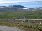
Saltfjellet is a mountain
area in Nordland
, Norway
that separates the two regions of Helgeland
and Salten
. It is also a cultural border between the Southern and Central parts of Sápmi.
cuts through the country. This range is part of seven municipalities: The northern part is part of Saltdal
, Bodø
, Beiarn
and Gildeskål
, the western part is in Meløy
and Rødøy
while the southern part is in Rana
.
The highest mountain is Ølfjellet
1,751 m above sea level. The mountains stretch from the coast to the Swedish border. The glacier
Svartisen
is actually two glaciers, separated by the Glomdalen valley with the Glomåga river. Western Svartisen is the second largest glacier on the Norwegian mainland, and is part of the Saltfjellet-Svartisen National Park
. There are many other glaciers as well. A total of 2,587 km² of the area is protected. Several long valleys radiate from the mountains, such as Dunderlandsdal
and Blakkådalen going south from the mountains, and Saltdal
and Beiardalen going northwards. The eastern part of the range forms a plateau with some gently sloping mountains, and this is where the road and railway crosses over Saltfjell. Both road and railway take advantage of the Dunderlandsdal and the Saltdal valley to make the distance on the alpine tundra
, which often sees snowstorms in winter, as short as possible. The western part is more alpine and steep, and this is where the engabreen glacier tongue of Western Svartisen almost reaches down to the fjord.
and the railway line Nordlandsbanen
. E6 was opened in 1937 and was asphalted in 1972. Until 1968 the road was closed in the winter. The railway line was built over the mountain during World War II
and opened in 1947.
, the last element is the finite form of fjell n 'fell, mountain'.
Mountain
Image:Himalaya_annotated.jpg|thumb|right|The Himalayan mountain range with Mount Everestrect 58 14 160 49 Chomo Lonzorect 200 28 335 52 Makalurect 378 24 566 45 Mount Everestrect 188 581 920 656 Tibetan Plateaurect 250 406 340 427 Rong River...
area in Nordland
Nordland
is a county in Norway in the North Norway region, bordering Troms in the north, Nord-Trøndelag in the south, Norrbottens län in Sweden to the east, Västerbottens län to the southeast, and the Atlantic Ocean to the west. The county was formerly known as Nordlandene amt. The county administration is...
, Norway
Norway
Norway , officially the Kingdom of Norway, is a Nordic unitary constitutional monarchy whose territory comprises the western portion of the Scandinavian Peninsula, Jan Mayen, and the Arctic archipelago of Svalbard and Bouvet Island. Norway has a total area of and a population of about 4.9 million...
that separates the two regions of Helgeland
Helgeland
Helgeland is the most southerly district in Northern Norway. Generally speaking, Helgeland refers to the part of Nordland county that is located south of the Arctic Circle. The district covers an area of about , with nearly 79,000 inhabitants...
and Salten
Salten
Salten is a district in Nordland in North Norway, consisting of the municipalities Meløy, Gildeskål, Bodø, Beiarn, Saltdal, Fauske, Sørfold, Steigen and Hamarøy. The district borders Helgeland in the south , Ofoten in the north, Sweden in the east and Vestfjorden in the west...
. It is also a cultural border between the Southern and Central parts of Sápmi.
Geography and environment
The Saltfjell is one of the largest mountain ranges in Norway, and is also where the Arctic CircleArctic Circle
The Arctic Circle is one of the five major circles of latitude that mark maps of the Earth. For Epoch 2011, it is the parallel of latitude that runs north of the Equator....
cuts through the country. This range is part of seven municipalities: The northern part is part of Saltdal
Saltdal
-Transportation:European route E6 passes through the entire length of Saltdal, with the Nordlandsbanen railway running alongside it. A road running east through the Junkerdalen valley leads to Sweden. The nearest main airport is in Bodø, a nearly two hour drive from Rognan.- Economy :Saltdal has a...
, Bodø
Bodø
is a city and a municipality in Nordland county, Norway. It is part of the Salten region.The city of Bodø was established as a municipality on 1 January 1838 . Bodin was merged with Bodø on 1 January 1968. Skjerstad was merged with Bodø on 1 January 2005...
, Beiarn
Beiarn
Beiarn is a municipality in Nordland county, Norway. It is part of the Salten region and the Bodø Region. The administrative centre of the municipality is the village of Moldjord...
and Gildeskål
Gildeskål
Gildeskål is a municipality in Nordland county, Norway. It is part of the Salten traditional region. The administrative centre of the municipality is the village of Inndyr. Gildeskål was established as a municipality on 1 January 1838 . Beiarn was separated from Gildeskål in 1853...
, the western part is in Meløy
Meløy
Meløy is a municipality in Nordland county, Norway. It is part of the Salten traditional region. The administrative centre of the municipality is the village of Ørnes, while Glomfjord is only slightly smaller. Meløy was separated from the municipality of Rødøy on 1 January 1884.The municipality...
and Rødøy
Rødøy
Rødøy is a municipality in Nordland county, Norway. It is part of the Helgeland traditional region. The administrative centre of the municipality is the village of Vågaholmen. The municipality consists of islands outside Norway's second biggest glacier, Svartisen.Rødøy was established as a...
while the southern part is in Rana
Rana, Norway
Rana is the second largest municipality in Nordland county – and the third largest in North Norway – by population. By area, Rana is largest in Norway south of Finnmark , taking in large areas of mountains and forested valleys. It is part of the Helgeland traditional region...
.
The highest mountain is Ølfjellet
Ølfjellet
Ølfjellet is the highest mountain in the mountain range Saltfjellet, in Nordland, Norway.The mountain has two peaks, the highest being 1,751 meters...
1,751 m above sea level. The mountains stretch from the coast to the Swedish border. The glacier
Glacier
A glacier is a large persistent body of ice that forms where the accumulation of snow exceeds its ablation over many years, often centuries. At least 0.1 km² in area and 50 m thick, but often much larger, a glacier slowly deforms and flows due to stresses induced by its weight...
Svartisen
Svartisen
Svartisen is a collective term for two glaciers located in northern Norway. The system consists of two separate glaciers,* Vestre Svartisen , which is the second largest glacier on the Norwegian mainland after Jostedalsbreen* Østre Svartisen , which...
is actually two glaciers, separated by the Glomdalen valley with the Glomåga river. Western Svartisen is the second largest glacier on the Norwegian mainland, and is part of the Saltfjellet-Svartisen National Park
Saltfjellet-Svartisen National Park
Saltfjellet–Svartisen National Park is a national park in the county of Nordland in Norway. It is located within the municipalities of Beiarn, Meløy, Rana, Rødøy, Saltdal and Bodø...
. There are many other glaciers as well. A total of 2,587 km² of the area is protected. Several long valleys radiate from the mountains, such as Dunderlandsdal
Dunderlandsdal
Dunderlandsdalen is a valley in Rana municipality in the county of Nordland, Norway. From just below the plateau of eastern Saltfjellet, it continues south-westward to the Ranfjord...
and Blakkådalen going south from the mountains, and Saltdal
Saltdal
-Transportation:European route E6 passes through the entire length of Saltdal, with the Nordlandsbanen railway running alongside it. A road running east through the Junkerdalen valley leads to Sweden. The nearest main airport is in Bodø, a nearly two hour drive from Rognan.- Economy :Saltdal has a...
and Beiardalen going northwards. The eastern part of the range forms a plateau with some gently sloping mountains, and this is where the road and railway crosses over Saltfjell. Both road and railway take advantage of the Dunderlandsdal and the Saltdal valley to make the distance on the alpine tundra
Alpine tundra
Alpine tundra is a natural region that does not contain trees because it is at high altitude. Alpine tundra is distinguished from arctic tundra, because alpine soils are generally better drained than arctic soils...
, which often sees snowstorms in winter, as short as possible. The western part is more alpine and steep, and this is where the engabreen glacier tongue of Western Svartisen almost reaches down to the fjord.
Transport
There are two main transport routes over the mountains, the highway European route E6European route E6
European route E 6 is the designation for the main north-south road in Norway, and the west coast of Sweden, running from the southern tip of Sweden, at Trelleborg, into Norway and through almost all of the country north to Finnmark. The route ends close to the Norwegian border with Russia...
and the railway line Nordlandsbanen
Nordlandsbanen
The Nordland Line is a railway line between Trondheim and Bodø in Norway. Running for approximately 729 km, it is the Norwegian railway system's longest line, and the only one in Norway to cross the Arctic Circle. It is owned by the Norwegian National Rail Administration...
. E6 was opened in 1937 and was asphalted in 1972. Until 1968 the road was closed in the winter. The railway line was built over the mountain during World War II
World War II
World War II, or the Second World War , was a global conflict lasting from 1939 to 1945, involving most of the world's nations—including all of the great powers—eventually forming two opposing military alliances: the Allies and the Axis...
and opened in 1947.
The name
The mountain is named after the district SaltenSalten
Salten is a district in Nordland in North Norway, consisting of the municipalities Meløy, Gildeskål, Bodø, Beiarn, Saltdal, Fauske, Sørfold, Steigen and Hamarøy. The district borders Helgeland in the south , Ofoten in the north, Sweden in the east and Vestfjorden in the west...
, the last element is the finite form of fjell n 'fell, mountain'.
External links
- Rana DNT Mountain cabins Rødøy municipality:About Saltfjellet with pictures