

Salmon Inlet
Encyclopedia
Fjord
Geologically, a fjord is a long, narrow inlet with steep sides or cliffs, created in a valley carved by glacial activity.-Formation:A fjord is formed when a glacier cuts a U-shaped valley by abrasion of the surrounding bedrock. Glacial melting is accompanied by rebound of Earth's crust as the ice...
branching east from Sechelt Inlet
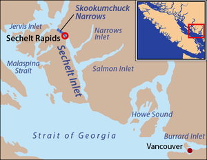
Sechelt Inlet
Sechelt Inlet is one of the principal inlets of the British Columbia Coast and the third of such inlets north from the 49th parallel north, the first of which is Burrard Inlet, Vancouver's harbour. The inlet is significant in that it almost makes an island of what is instead the Sechelt Peninsula,...
in the British Columbia
British Columbia
British Columbia is the westernmost of Canada's provinces and is known for its natural beauty, as reflected in its Latin motto, Splendor sine occasu . Its name was chosen by Queen Victoria in 1858...
, Canada
Canada
Canada is a North American country consisting of ten provinces and three territories. Located in the northern part of the continent, it extends from the Atlantic Ocean in the east to the Pacific Ocean in the west, and northward into the Arctic Ocean...
. Its companion, Narrows Inlet, another side-inlet of Sechelt Inlet, lies roughly 25 miles (40.2 km) north. Misery and Sechelt Creeks flow freely into the inlet, while the Clowhom River
Clowhom River
The Clowhom River is a short, river in British Columbia. It flows into the head of the Salmon Inlet about 26.2 km west of Squamish.- Course :...
flows in from the artificial Clowhom Lake
Clowhom Lake
Clowhom Lake is a reservoir in the Sechelt Inlet basin, located on the Clowhom River at the upper end of Salmon Inlet, the southern side-inlet of Sechelt Inlet. Formed by Clowhom Dam, the reservoir was formerly two lakes, Upper Clowhom Lake and Lower Clowhom Lake, and had been referred to prior...
, formed by a small hydroelectric power development. The fjord is 23 kilometres (14.3 mi) long; Clowhom Lake, covering a waterfall on the Clowhom River, stretches a further 12 kilometres (7.5 mi) to the western base of Mount Tantalus
Mount Tantalus
Mount Tantalus is a mountain in southwestern British Columbia, Canada, located southeast of Falk Lake and south of Monmouth Mountain. It is the highest mountain in the Tantalus Range of the Pacific Ranges and is famous for its snow covered face....
, which is best-known from the direction of Squamish and the Cheakamus Canyon stretch of BC Hwy 99
British Columbia provincial highway 99
Highway 99, also known as the Sea to Sky Highway, the Squamish Highway, Route 99, or Whistler Highway, is the major north-south artery running through the Greater Vancouver area of British Columbia from the U.S. border, up Howe Sound through the Sea to Sky Country to Lillooet, and connecting to...
. Heavily affected by logging
Logging
Logging is the cutting, skidding, on-site processing, and loading of trees or logs onto trucks.In forestry, the term logging is sometimes used in a narrow sense concerning the logistics of moving wood from the stump to somewhere outside the forest, usually a sawmill or a lumber yard...
and milling
Mill (grinding)
A grinding mill is a unit operation designed to break a solid material into smaller pieces. There are many different types of grinding mills and many types of materials processed in them. Historically mills were powered by hand , working animal , wind or water...
operations, the inlet is split almost into two portions by an alluvial fan
Alluvial fan
An alluvial fan is a fan-shaped deposit formed where a fast flowing stream flattens, slows, and spreads typically at the exit of a canyon onto a flatter plain. A convergence of neighboring alluvial fans into a single apron of deposits against a slope is called a bajada, or compound alluvial...
spreading from the mouth of Sechelt Creek.