

Salado River (Buenos Aires)
Encyclopedia
Buenos Aires Province
The Province of Buenos Aires is the largest and most populous province of Argentina. It takes the name from the city of Buenos Aires, which used to be the provincial capital until it was federalized in 1880...
, Argentina
Argentina
Argentina , officially the Argentine Republic , is the second largest country in South America by land area, after Brazil. It is constituted as a federation of 23 provinces and an autonomous city, Buenos Aires...
. It originates at El Chañar Lake on the border with Santa Fe Province
Santa Fe Province
The Invincible Province of Santa Fe, in Spanish Provincia Invencible de Santa Fe , is a province of Argentina, located in the center-east of the country. Neighboring provinces are from the north clockwise Chaco , Corrientes, Entre Ríos, Buenos Aires, Córdoba, and Santiago del Estero...
, 40 metres (131.2 ft) above mean sea level
Above mean sea level
The term above mean sea level refers to the elevation or altitude of any object, relative to the average sea level datum. AMSL is used extensively in radio by engineers to determine the coverage area a station will be able to reach...
, and flows generally southeast for 640 kilometres (397.7 mi) before debouching into Samborombón Bay
Samborombón Bay
Samborombón Bay is a bay of Argentina, located at the Río de la Plata's mouth on the Atlantic Ocean. It is about southeast of Buenos Aires. The bay is about long and stretches from Point Piedras in the north to Point Norte, starting point of Cape San Antonio.The bay receives the Salado and...
, part of the Río de la Plata
Río de la Plata
The Río de la Plata —sometimes rendered River Plate in British English and the Commonwealth, and occasionally rendered [La] Plata River in other English-speaking countries—is the river and estuary formed by the confluence of the Uruguay River and the Paraná River on the border between Argentina and...
estuary
Estuary
An estuary is a partly enclosed coastal body of water with one or more rivers or streams flowing into it, and with a free connection to the open sea....
on the Atlantic Ocean
Atlantic Ocean
The Atlantic Ocean is the second-largest of the world's oceanic divisions. With a total area of about , it covers approximately 20% of the Earth's surface and about 26% of its water surface area...
. The Salado's mouth is about 170 kilometres (105.6 mi) south of the city of Buenos Aires
Buenos Aires
Buenos Aires is the capital and largest city of Argentina, and the second-largest metropolitan area in South America, after São Paulo. It is located on the western shore of the estuary of the Río de la Plata, on the southeastern coast of the South American continent...
.
The Salado's drainage basin
Drainage basin
A drainage basin is an extent or an area of land where surface water from rain and melting snow or ice converges to a single point, usually the exit of the basin, where the waters join another waterbody, such as a river, lake, reservoir, estuary, wetland, sea, or ocean...
is about 170000 square kilometres (65,637.4 sq mi), which is over half of the province's area. The region receives an annual average of 2000 millimetre of precipitation, which often causes flood
Flood
A flood is an overflow of an expanse of water that submerges land. The EU Floods directive defines a flood as a temporary covering by water of land not normally covered by water...
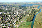
ing in the low-lying area. The river flows by the cities of Junín
Junín, Buenos Aires
Junín is a city in the province of Buenos Aires, Argentina, and capital of the municipality of Junín. It has a population of 82,427 and is situated 260 km west of Buenos Aires.-History:...
, Roque Pérez
Roque Pérez
Roque Pérez is a town in Buenos Aires Province, Argentina. It is the head town of the Roque Pérez Partido.-External links:...
, and General Belgrano
General Belgrano, Buenos Aires
General Belgrano is a town in Buenos Aires Province, Argentina. It is the head town of the General Belgrano Partido....
, as well as a number of wetlands and lakes; channelization of the lower course has improved the drainage of the river's 88 m3/s. Nearly 1 million people live in the basin.
Hydrological studies have been performed in the Salado basin, principally in the Azul, Buenos Aires
Azul, Buenos Aires
Azul is the head city of the Azul Partido, located at the center of the Buenos Aires Province in Argentina, 300 km south of Buenos Aires. It has 63,000 inhabitants as per the ....
creek basin by the Instituto de Hidrologia de Llanuras de Azul. Ecological studies have been done by the Ecology group of Facultad de Agronomía de la UNICEN.
In the 19th century, before the Conquest of the Desert
Conquest of the Desert
The Conquest of the Desert was a military campaign directed mainly by General Julio Argentino Roca in the 1870s, which established Argentine dominance over Patagonia, which was inhabited by indigenous peoples...
, the Salado River served as frontier boundary between the Spanish colonised lands and those still under control of the indigenous peoples
Indigenous peoples of the Americas
The indigenous peoples of the Americas are the pre-Columbian inhabitants of North and South America, their descendants and other ethnic groups who are identified with those peoples. Indigenous peoples are known in Canada as Aboriginal peoples, and in the United States as Native Americans...
.
Because Argentina has another, more important Salado River, in the northern part of the country, this Saldo River is sometimes called Salado del Sur ("Southern Salado").