
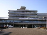
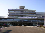
Sagamihara, Kanagawa
Encyclopedia
is a city
located in north central Kanagawa Prefecture
, bordering Tokyo
, Japan
. It is the third most populous city in the prefecture, after Yokohama
and Kawasaki
, and the fifth most populous suburb
of Greater Tokyo. Its northern neighbor is Machida
, with which a cross-prefectural merger has been proposed. As of 2010, the city has an estimated population
of 712,883 and a population density
of 2,170 persons per km². The total area was 328.84 km².
On April 1, 2010, the city became the nation's 19th city designated by government ordinance. As a result of this, the city established three wards: Midori-ku
, Chūō-ku
and Minami-ku
.
on the JR East
Yokohama Line and Keio Sagamihara Line
; Sagamihara Station
on the Yokohama Line; and Sagami-Ōno Station
on the Odakyū Odawara Line. Western Sagamihara is within the Tanzawa Mountains.
 The area of modern Sagamihara has been settled since ancient times, and has a number of remains from the Japanese Paleolithic
period and Kofun period
have been found. It was home to the Yokoyama clan, one of the seven warrior clans of the Musashi region
during the early Kamakura period
. During the Edo period
, the lands around Sagamihara were tenryō territory theoretically administered directly by the Tokugawa Shogunate
in Edo
; however, in reality, the area was a patchwork of small fiefs held by various hatamoto
, as well as exclaves under the control of Ogino-Yamanaka Domain and Karasuyama Domain.
After the Meiji Restoration
, the southern portion became part of Kōza District
, and the northern portion was part of Aikō District
. The Koza district portion was administratively divided into six villages on April 1, 1889. The area was the location of extensive training facilities and arsenals of the Imperial Japanese Army
during the 1930s. These villages merged on April 29, 1941 together with neighboring Zama town
to form Sagamihara Town. At the time of its formation, it was the largest town in Japan in terms of area.
On September 1, 1948, Zama was administratively separated into Zama Town. The remaining portion became Sagamihara city on November 20, 1954. The city population had grown steadily, partly due to local industrial development, and partly due to the city’s excellent transportation infrastructure connecting it to Yokohama
, Tokyo
and Hachioji
. It was designated a Core city
with increased autonomy in 2003.
On March 20, 2006, Sagamihara merged with former Tsukui
and Sagamiko
villages. The merged city consisted of two geographically separate areas, as two other municipalities of Tsukui District
, Fujino
and Shiroyama
, elected to remain separate. A further merger on March 11, 2007 joined Fujino and Shiroyama with Sagamihara, thus geographically unifying the city, and dissolving former Tsukui District. In 2007, the population of Sagamihara exceeded 700,000. In 2010 Sagamihara was redesignated as a government ordinance city and split into 3 wards Midori-ku, Chūō-ku, and Minami-ku.
} - - - -
} -
} - -
, Canada, since April 15, 1991 Wuxi
, China, since October 6, 1985
Cities of Japan
||A is a local administrative unit in Japan. Cities are ranked on the same level as and , with the difference that they are not a component of...
located in north central Kanagawa Prefecture
Kanagawa Prefecture
is a prefecture located in the southern Kantō region of Japan. The capital is Yokohama. Kanagawa is part of the Greater Tokyo Area.-History:The prefecture has some archaeological sites going back to the Jōmon period...
, bordering Tokyo
Tokyo
, ; officially , is one of the 47 prefectures of Japan. Tokyo is the capital of Japan, the center of the Greater Tokyo Area, and the largest metropolitan area of Japan. It is the seat of the Japanese government and the Imperial Palace, and the home of the Japanese Imperial Family...
, Japan
Japan
Japan is an island nation in East Asia. Located in the Pacific Ocean, it lies to the east of the Sea of Japan, China, North Korea, South Korea and Russia, stretching from the Sea of Okhotsk in the north to the East China Sea and Taiwan in the south...
. It is the third most populous city in the prefecture, after Yokohama
Yokohama
is the capital city of Kanagawa Prefecture and the second largest city in Japan by population after Tokyo and most populous municipality of Japan. It lies on Tokyo Bay, south of Tokyo, in the Kantō region of the main island of Honshu...
and Kawasaki
Kawasaki, Kanagawa
is a city located in Kanagawa Prefecture, Japan, between Tokyo and Yokohama. It is the 9th most populated city in Japan and one of the main cities forming the Greater Tokyo Area and Keihin Industrial Area....
, and the fifth most populous suburb
Suburb
The word suburb mostly refers to a residential area, either existing as part of a city or as a separate residential community within commuting distance of a city . Some suburbs have a degree of administrative autonomy, and most have lower population density than inner city neighborhoods...
of Greater Tokyo. Its northern neighbor is Machida
Machida, Tokyo
is a city located in the western part of the greater metropolis of Tokyo, Japan. The city was founded on February 1, 1958.As of October 1, 2010, the city has an estimated population of 424,669 and a population density of 5,928.65 persons per km². The total area is 71.63 km²...
, with which a cross-prefectural merger has been proposed. As of 2010, the city has an estimated population
Population
A population is all the organisms that both belong to the same group or species and live in the same geographical area. The area that is used to define a sexual population is such that inter-breeding is possible between any pair within the area and more probable than cross-breeding with individuals...
of 712,883 and a population density
Population density
Population density is a measurement of population per unit area or unit volume. It is frequently applied to living organisms, and particularly to humans...
of 2,170 persons per km². The total area was 328.84 km².
On April 1, 2010, the city became the nation's 19th city designated by government ordinance. As a result of this, the city established three wards: Midori-ku
Midori-ku, Sagamihara
is one of three wards of Sagamihara, Kanagawa, Japan, located in the west part of the city and covered about 77% area. The east of Midori-ku faces Chūō-ku; the north faces Machida and Hachiōji....
, Chūō-ku
Chūō-ku, Sagamihara
is one of three wards of Sagamihara, Kanagawa, Japan, located in the central part of the city. The north west of Chūō-ku faces Midori-ku; the south east faces Minami-ku; the north faces Machida....
and Minami-ku
Minami-ku, Sagamihara
is one of three wards of Sagamihara, Kanagawa, Japan, located in the east part of the city. The west of Minami-ku faces Chūō-ku.Minami-ku was created on April 1, 2010 when Sagamihara became a city designated by government ordinance ....
.
Geography
Sagamihara covers a large area of northwestern Kanagawa Prefecture. The main areas of commercial activity in Sagamihara are located near Hashimoto StationHashimoto Station (Kanagawa)
is a major stop on the East Japan Railway Company Yokohama Line, Sagami Line and the Keio Sagamihara Line straddling the city of Sagamihara in Kanagawa Prefecture, Japan.- JR East:- Keiō :-Surrounding area:*Midori Ward Office...
on the JR East
East Japan Railway Company
is the largest passenger railway company in the world and one of the seven Japan Railways Group companies. The company name is officially abbreviated as JR East in English, and as in Japanese. The company's headquarters are in Yoyogi, Shibuya, Tokyo....
Yokohama Line and Keio Sagamihara Line
Keio Sagamihara Line
The is a Japanese railway line operated by Keio Corporation, connecting Hashimoto Station in Sagamihara, Kanagawa Prefecture and Chōfu Station in Chōfu, Tokyo.-History:...
; Sagamihara Station
Sagamihara Station
is a commuter railway station on the East Japan Railway Company's Yokohama Line located in Chūō Ward, Sagamihara, Kanagawa Prefecture, Japan. It is 31.0 kilometers from the terminus of the Yokohama Line at Higashi-Kanagawa Station.- History :...
on the Yokohama Line; and Sagami-Ōno Station
Sagami-Ono Station
is a railway station in the city of Sagamihara, Kanagawa Prefecture, Japan, served by both the Odawara Line and the Enoshima Line of the Odakyū Electric Railway....
on the Odakyū Odawara Line. Western Sagamihara is within the Tanzawa Mountains.
Wards
- Midori-kuMidori-ku, Sagamiharais one of three wards of Sagamihara, Kanagawa, Japan, located in the west part of the city and covered about 77% area. The east of Midori-ku faces Chūō-ku; the north faces Machida and Hachiōji....
- Chūō-kuChūō-ku, Sagamiharais one of three wards of Sagamihara, Kanagawa, Japan, located in the central part of the city. The north west of Chūō-ku faces Midori-ku; the south east faces Minami-ku; the north faces Machida....
- administrative center - Minami-kuMinami-ku, Sagamiharais one of three wards of Sagamihara, Kanagawa, Japan, located in the east part of the city. The west of Minami-ku faces Chūō-ku.Minami-ku was created on April 1, 2010 when Sagamihara became a city designated by government ordinance ....
Kanagawa Prefecture
- ZamaZama, Kanagawais a city located in central Kanagawa Prefecture, Japan. The city is also home to the United States' Camp Zama Army base. As of 128,989, the city had an estimated population of 128,989 and a density of 7,320 persons per km². The total area was 17.58 km²....
- YamatoYamato, Kanagawais a city located in central Kanagawa Prefecture, Japan. As of 2010, the city had an estimated population of 225,866 and a density of 8,320 persons per km². The total area was 27.06 km².-Surrounding municipalities:*Zama*Fujisawa*Ebina*Sagamihara*Ayase...
- AtsugiAtsugi, Kanagawais a city located in central Kanagawa Prefecture, Japan. As of 2010, the city has an estimated population of 225,622 and a population density of 2,410 persons per km². The total area was 93.83 km²...
- AikawaAikawa, Kanagawais a town located in Aikō District, Kanagawa Prefecture, Japan. As of February 1, 2010, the town had an estimated population of 41,513 and a density of 1,210 persons per km². The total area was 34.29 km².-Geography:...
- KiyokawaKiyokawa, Kanagawais a village located in Aikō District, Kanagawa, Japan. As of 2010, the village had an estimated population of 3,556and a density of 49.9 persons per km². The total area is 71.29 km².-Geography:...
- YamakitaYamakita, Kanagawais a town located in Ashigarakami District, Kanagawa Prefecture, Japan. As of 2010, the town had an estimated population of 11,863 and a density of 52.8 persons per km². The total area was 224.70 km².-Geography:...
History
Japanese Paleolithic
The began around 50,000 to 30,000 BC, when the earliest stone tool implements have been found, and continued to around 14,000 BC, at the end of the last ice age, which corresponds to the beginning of the Mesolithic Jōmon period...
period and Kofun period
Kofun period
The is an era in the history of Japan from around 250 to 538. It follows the Yayoi period. The word kofun is Japanese for the type of burial mounds dating from this era. The Kofun and the subsequent Asuka periods are sometimes referred to collectively as the Yamato period...
have been found. It was home to the Yokoyama clan, one of the seven warrior clans of the Musashi region
Musashi Province
was a province of Japan, which today comprises Tokyo Prefecture, most of Saitama Prefecture and part of Kanagawa Prefecture. It was sometimes called . The province encompassed Kawasaki and Yokohama...
during the early Kamakura period
Kamakura period
The is a period of Japanese history that marks the governance by the Kamakura Shogunate, officially established in 1192 in Kamakura by the first shogun Minamoto no Yoritomo....
. During the Edo period
Edo period
The , or , is a division of Japanese history which was ruled by the shoguns of the Tokugawa family, running from 1603 to 1868. The political entity of this period was the Tokugawa shogunate....
, the lands around Sagamihara were tenryō territory theoretically administered directly by the Tokugawa Shogunate
Tokugawa shogunate
The Tokugawa shogunate, also known as the and the , was a feudal regime of Japan established by Tokugawa Ieyasu and ruled by the shoguns of the Tokugawa family. This period is known as the Edo period and gets its name from the capital city, Edo, which is now called Tokyo, after the name was...
in Edo
Edo
, also romanized as Yedo or Yeddo, is the former name of the Japanese capital Tokyo, and was the seat of power for the Tokugawa shogunate which ruled Japan from 1603 to 1868...
; however, in reality, the area was a patchwork of small fiefs held by various hatamoto
Hatamoto
A was a samurai in the direct service of the Tokugawa shogunate of feudal Japan. While all three of the shogunates in Japanese history had official retainers, in the two preceding ones, they were referred to as gokenin. However, in the Edo period, hatamoto were the upper vassals of the Tokugawa...
, as well as exclaves under the control of Ogino-Yamanaka Domain and Karasuyama Domain.
After the Meiji Restoration
Meiji Restoration
The , also known as the Meiji Ishin, Revolution, Reform or Renewal, was a chain of events that restored imperial rule to Japan in 1868...
, the southern portion became part of Kōza District
Koza District, Kanagawa
is an administrative district of Japan located in central Kanagawa Prefecture. It currently consists of only one town, Samukawa.- History :Kōza District was one of the ancient subdivisions of Sagami Province, extending from Sagami Bay north to the border of Musashi Province between the Sagami River...
, and the northern portion was part of Aikō District
Aiko District, Kanagawa
is an administrative district of Japan located in central Kanagawa Prefecture. It currently consists of only one town, Aikawa, and one village, Kiyokawa.-History:...
. The Koza district portion was administratively divided into six villages on April 1, 1889. The area was the location of extensive training facilities and arsenals of the Imperial Japanese Army
Imperial Japanese Army
-Foundation:During the Meiji Restoration, the military forces loyal to the Emperor were samurai drawn primarily from the loyalist feudal domains of Satsuma and Chōshū...
during the 1930s. These villages merged on April 29, 1941 together with neighboring Zama town
Zama, Kanagawa
is a city located in central Kanagawa Prefecture, Japan. The city is also home to the United States' Camp Zama Army base. As of 128,989, the city had an estimated population of 128,989 and a density of 7,320 persons per km². The total area was 17.58 km²....
to form Sagamihara Town. At the time of its formation, it was the largest town in Japan in terms of area.
On September 1, 1948, Zama was administratively separated into Zama Town. The remaining portion became Sagamihara city on November 20, 1954. The city population had grown steadily, partly due to local industrial development, and partly due to the city’s excellent transportation infrastructure connecting it to Yokohama
Yokohama
is the capital city of Kanagawa Prefecture and the second largest city in Japan by population after Tokyo and most populous municipality of Japan. It lies on Tokyo Bay, south of Tokyo, in the Kantō region of the main island of Honshu...
, Tokyo
Tokyo
, ; officially , is one of the 47 prefectures of Japan. Tokyo is the capital of Japan, the center of the Greater Tokyo Area, and the largest metropolitan area of Japan. It is the seat of the Japanese government and the Imperial Palace, and the home of the Japanese Imperial Family...
and Hachioji
Hachioji, Tokyo
is a city located in Tokyo, Japan, about 40 kilometers west of the center of the special wards of Tokyo.As of January 1, 2010, the city has an estimated population of 551,901 and a population density of 2,962.27/km². The total area is 186.31 km². It is the eighth largest city in the...
. It was designated a Core city
Core city
A is a class of Japanese city created by the first clause of Article 252, Section 22 of the Local Autonomy Law of Japan. Core cities are delegated many functions normally carried out by prefectural governments, but not as many as designated cities...
with increased autonomy in 2003.
On March 20, 2006, Sagamihara merged with former Tsukui
Tsukui, Kanagawa
was a town located in Tsukui District, Kanagawa, Japan.On March 20, 2006 Tsukui, along with the town of Sagamiko, also from Tsukui District, was merged into the expanded city of Sagamihara, and thus no longer exists as an independent municipality...
and Sagamiko
Sagamiko, Kanagawa
was a town located in Tsukui District, Kanagawa, Japan.On March 20, 2006 Sagamiko, along with the town of Tsukui, also from Tsukui District, was merged into the expanded city of Sagamihara, and thus no longer exists as an independent municipality...
villages. The merged city consisted of two geographically separate areas, as two other municipalities of Tsukui District
Tsukui District, Kanagawa
was formerly a district located in Kanagawa Prefecture, Japan. It was abolished on March 11, 2007 through merger into the neighboring city of Sagamihara.As of July 1, 2004, the district had an estimated population of 73,718. The total area was 238.44 km²...
, Fujino
Fujino, Kanagawa
was a town located in Tsukui District, Kanagawa Prefecture, Japan.On March 11, 2007 Fujino, along with the town of Shiroyama, also from Tsukui District, was merged into the expanded city of Sagamihara, and thus no longer exists as an independent municipality....
and Shiroyama
Shiroyama, Kanagawa
was a town located in Tsukui District, Kanagawa Prefecture, Japan.On March 11, 2007 Shiroyama, along with the town of Fujino, also from Tsukui District, was merged into the expanded city of Sagamihara, and thus no longer exists as an independent municipality. It is now part of Midori-ku...
, elected to remain separate. A further merger on March 11, 2007 joined Fujino and Shiroyama with Sagamihara, thus geographically unifying the city, and dissolving former Tsukui District. In 2007, the population of Sagamihara exceeded 700,000. In 2010 Sagamihara was redesignated as a government ordinance city and split into 3 wards Midori-ku, Chūō-ku, and Minami-ku.
Railway
- JR EastEast Japan Railway Companyis the largest passenger railway company in the world and one of the seven Japan Railways Group companies. The company name is officially abbreviated as JR East in English, and as in Japanese. The company's headquarters are in Yoyogi, Shibuya, Tokyo....
- Yokohama Line
} - - - -
- JR EastEast Japan Railway Companyis the largest passenger railway company in the world and one of the seven Japan Railways Group companies. The company name is officially abbreviated as JR East in English, and as in Japanese. The company's headquarters are in Yoyogi, Shibuya, Tokyo....
- Sagami Line- - - - - - -
- JR EastEast Japan Railway Companyis the largest passenger railway company in the world and one of the seven Japan Railways Group companies. The company name is officially abbreviated as JR East in English, and as in Japanese. The company's headquarters are in Yoyogi, Shibuya, Tokyo....
- Chuo Main LineChuo Main LineThe , commonly called the Chūō Line, is one of the major trunk railway lines in Japan. It runs between Tokyo and Nagoya, although it is the slowest direct railway connection between the two cities; the coastal Tōkaidō Main Line is slightly faster, while the Tōkaidō Shinkansen is the fastest rail...
} -
- Odakyū Electric RailwayOdakyu Electric Railway, or OER, is a major railway company based in Tokyo, Japan best known for its Romancecar series of limited express trains from Tokyo to Odawara, Enoshima, Tama New Town, and Hakone....
-Odakyū Odawara Line
} - -
- Keio Railway- Sagamihara Line
Highways
- Chuo ExpresswayChuo ExpresswayThe is a national expressway in Japan. It is owned and operated by Central Nippon Expressway Company.-Naming:Officially the expressway is designated as the Chūō Expressway Nishinomiya Route , the Chūō Expressway Nagano Route , and the Chūō Expressway Fujiyoshida Route The (lit. Central...
- Ken-Ō ExpresswayKen-O ExpresswayThe , or , is a partially completed ticket system toll expressway in Japan, owned and operated by the Central Nippon Expressway Company and East Nippon Expressway Company. In conjunction with the Tokyo Bay Aqua-Line and the Bayshore Route of the Shuto Expressway, it will form a full outer ring road...
- Japan National Route 16
- Japan National Route 20
- Japan National Route 129
- Japan National Route 412
- Japan National Route 413
Sister cities
Toronto, Ontario, Canada since January 1, 1998 Trail, British ColumbiaTrail, British Columbia
Trail is a city in the West Kootenay region of the Interior of British Columbia, Canada.-Geography:Trail has an area of . The city is located on both banks of the Columbia River, approximately 10 km north of the United States border. This section of the Columbia River valley is located between the...
, Canada, since April 15, 1991 Wuxi
Wuxi
Wuxi is an old city in Jiangsu province, People's Republic of China. Split in half by Lake Tai, Wuxi borders Changzhou to the west and Suzhou to the east. The northern half looks across to Taizhou across the Yangtze River, while the southern half also borders the province of Zhejiang to the south...
, China, since October 6, 1985