

Safe water mark
Encyclopedia
International Association of Lighthouse Authorities
The International Association of Marine Aids to Navigation and Lighthouse Authorities is a non-profit organization founded in 1957 to collect and provide nautical expertise and advice.-Background:...
, is a sea mark
Sea mark
A sea mark, also seamark and navigation mark, is a form of aid to navigation and pilotage aid which identifies the approximate position of a maritime channel, hazard and administrative area to allow boats, ships and seaplanes to navigate safely....
used in maritime pilotage
Pilotage
Pilotage is the use of fixed visual references on the ground or sea by means of sight or radar to guide oneself to a destination, sometimes with the help of a map or nautical chart. People use pilotage for activities such as guiding vessels and aircraft, hiking and Scuba diving...
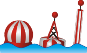
to indicate the end of a channel. It usually implies that open, deep and safe water lies ahead, though it is sometimes also used to indicate the start and end of a buoyed section of a continuous narrow channel, or a line of these marks can be used to mark a safe route through shallow areas. It is therefore important to consult an appropriate chart to determine the exact meaning in each case. The marker is also sometimes known as a Fairway Buoy.
It is recognisable by its red and white vertical stripes and commonly bears a top-sign in shape of a red ball. Lighted buoys flash morse code
Morse code
Morse code is a method of transmitting textual information as a series of on-off tones, lights, or clicks that can be directly understood by a skilled listener or observer without special equipment...
"A", occulting (more light than dark), Isophase (equal light and dark) or long flash every 10 seconds (L Fl 10s) .
In the United States, safe water marks have the initials of their associated waterways or localities printed on them.
Lighted buoy flashes morse code "T" (one long flash) with intervals of 6 seconds
See also
- NavigationNavigationNavigation is the process of monitoring and controlling the movement of a craft or vehicle from one place to another. It is also the term of art used for the specialized knowledge used by navigators to perform navigation tasks...
- Lateral markLateral markA lateral buoy, lateral post or lateral mark, as defined by the International Association of Lighthouse Authorities, is a sea mark used in maritime pilotage to indicate the edge of a channel....
- Cardinal markCardinal markA cardinal mark is a sea mark used in maritime pilotage to indicate the position of a hazard and the direction of safe water....
- Isolated danger markIsolated danger markAn Isolated Danger Mark, as defined by the International Association of Lighthouse Authorities, is a sea mark used in maritime pilotage to indicate a hazard to shipping such as a partially submerged rock....
- Special markSpecial markA Special Mark, as defined by the International Association of Lighthouse Authorities, is a sea mark used in maritime pilotage to indicate the boundary of an obstruction, administrative area such as a speed limit, water skiing or mooring area, or to highlight other features such as outfall sewerage...