

Sabrina Island (Azores)
Encyclopedia
São Miguel Island
São Miguel Island , nicknamed "The Green Island", is the largest and most populous island in the Portuguese Azores archipelago. The island covers and has around 140,000 inhabitants, 45,000 of these people located in the largest city in the archipelago: Ponta Delgada.-History:In 1427, São Miguel...
, Azores
Azores
The Archipelago of the Azores is composed of nine volcanic islands situated in the middle of the North Atlantic Ocean, and is located about west from Lisbon and about east from the east coast of North America. The islands, and their economic exclusion zone, form the Autonomous Region of the...
, one of many that have been felt in the Sete Cidades Massif over time. The first person to land in the new island was Captain James Tillard, commander of the British warship HMS Sabrina, who hoisted the Union Jack on the island and claimed sovereignty for Great Britain
Great Britain
Great Britain or Britain is an island situated to the northwest of Continental Europe. It is the ninth largest island in the world, and the largest European island, as well as the largest of the British Isles...
. After a diplomatic row over the issue started, the island vanished under the sea.
History
Between January and February 1811, a prolonged period of seismic activity affected the settlements to the extreme southeast, in particular, the parish of GinetesGinetes
Ginetes is a civil parish in the municipality of Ponta Delgada on the island of São Miguel in the Azores. There were 1267 inhabitants , in an area of 12.07 km² that lies on the eastern flank of the Sete Cidades Massif, south of the parish Mosteiros, and linked via the Estrada Regional roadway to...
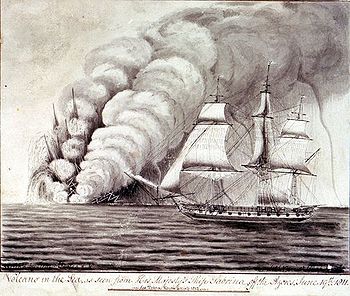
. During these months, gases were emitted from the ocean around Ponta da Ferraria, but, by the end of the month of February they abruptly ceased. New tremors returned in May and June, destroying many homes. Finally on June 10, 1811, in an area about 3 nautical miles (5.6 km) from the original seismic zones, and about 2 kilometers off the coast, a submarine eruption occurred alongside Ponta da Ferreira, killing fish of many species. A circular cone formed that had a perimeter of 2 kilometers, and 90 meters in height (similar in respects to the Islet of Vila Franca do Campo) with an open ring to the northwest. From the central ring debris escaped into the sea.
On June 12, the eruption was visible by a the British sloop H.M.S. Sabrina (built in 1806), which was a ship armed with 20 cannons, and sent to the Azores to monitor French naval movements in the waters of the Azores. The commander, Captain James Tillard, thinking that the grey clouds in the area were from a naval battle, sailed into the area, found a situation that was quite different than he originally imagined. The description of the eruption was eventually written in the Philosophical Transactions of the Royal Society of 1822.