

S bridge
Encyclopedia
Bridge
A bridge is a structure built to span physical obstacles such as a body of water, valley, or road, for the purpose of providing passage over the obstacle...
, shaped roughly like a shallow letter S
S
S is the nineteenth letter in the ISO basic Latin alphabet.-History: Semitic Šîn represented a voiceless postalveolar fricative . Greek did not have this sound, so the Greek sigma came to represent...
, used in early 19th century road construction in the United States
United States
The United States of America is a federal constitutional republic comprising fifty states and a federal district...
. They were generally used for crossing small, curving stream
Stream
A stream is a body of water with a current, confined within a bed and stream banks. Depending on its locale or certain characteristics, a stream may be referred to as a branch, brook, beck, burn, creek, "crick", gill , kill, lick, rill, river, syke, bayou, rivulet, streamage, wash, run or...
s with uneven banks. These bridges are found in and around the New Concord, Ohio
New Concord, Ohio
New Concord is a village in Muskingum County, Ohio, United States. The population was 2,651 at the 2000 census. New Concord is the home of Muskingum University and is served by a branch of the Muskingum County Library System.-Geography:...
area.
S bridges were originally constructed early in the 19th century. The design was adopted where the road crossed the creek or river at an angle. Constructing a bridge at an angle
Skew arch
A skew arch is a method of construction that enables an arch bridge to span an obstacle at some angle other than a right angle. This results in the faces of the arch not being perpendicular to its abutments and its plan view being a parallelogram, rather than the rectangle that is the plan view of...
was much more complicated and expensive than building the bridge perpendicular to the water flow and banks. The bridges were constructed at 90 degrees to the bank, while two 'aprons' were constructed at opposite angles to direct the traffic flow smoothly onto the bridge, thus creating the 's' shape.
Only a few of these bridges still exist, mostly in Ohio
Ohio
Ohio is a Midwestern state in the United States. The 34th largest state by area in the U.S.,it is the 7th‑most populous with over 11.5 million residents, containing several major American cities and seven metropolitan areas with populations of 500,000 or more.The state's capital is Columbus...
. Four of them are located in Guernsey County
Guernsey County, Ohio
Guernsey County is a county located in the state of Ohio. As of 2010, the population was 40,087. Its county seat is Cambridge and is named for the Isle of Guernsey in the English Channel, from which many of the county's early settlers came....
, two of which are still in use carrying traffic. Fox Run S bridge is located along US Route 40 in New Concord in Muskingum County
Muskingum County, Ohio
Muskingum County is a county located in the state of Ohio, United States. As of the 2010 census, the population was 86,074. Its county seat is Zanesville...
. The next bridge, four and a half miles east from New Concord
New Concord, Ohio
New Concord is a village in Muskingum County, Ohio, United States. The population was 2,651 at the 2000 census. New Concord is the home of Muskingum University and is served by a branch of the Muskingum County Library System.-Geography:...
on US Route 40, is found at the intersection of US 40 and Peter's Creek Road. Continuing eastward, the next bridge may be found a short distance from US 40 on Manilla Road; this bridge is still in use but may not be noticeable as it has been paved over and has had guardrails added to it. The next "S" bridge is 1.5 miles east of Cambridge
Cambridge, Ohio
As of the census of 2000, there were 11,520 people, 4,924 households, and 2,954 families residing in the city. The population density was 2,055.1 people per square mile . There were 5,585 housing units of an average density of 996.3 per square mile...
along US 40 at its intersection with Old National Road and has fallen into considerable disrepair. The fourth bridge
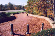
S Bridge, National Road
The S Bridge derives its name from its sharply-curving approaches. Built in 1828, the single-arch stone bridge on Bridgewater Road carried the National Road and is one of four S bridges in Guernsey County, Ohio....
is located between Old Washington, Ohio
Old Washington, Ohio
Old Washington is a village in Guernsey County, Ohio, United States. The population was 265 at the 2000 census.-History:In July 1863, Old Washington was the site of a small engagement during the course of Morgan's Raid...
and Middlebourne, Ohio along Bridgewater Road, at the intersection of Blend Road, and has been designated a National Historic Landmark
National Historic Landmark
A National Historic Landmark is a building, site, structure, object, or district, that is officially recognized by the United States government for its historical significance...
. This bridge is still accessible to local traffic.
These four bridges were constructed as a part of the original National Road
National Road
The National Road or Cumberland Road was the first major improved highway in the United States to be built by the federal government. Construction began heading west in 1811 at Cumberland, Maryland, on the Potomac River. It crossed the Allegheny Mountains and southwestern Pennsylvania, reaching...
, which was built circa 1825.
The Claysville S Bridge
Claysville S Bridge
The Claysville "S" Bridge is a historic S bridge in Washington County, Pennsylvania.It is designated as a historic bridge by the Washington County History & Landmarks Foundation....
, in Washington County, Pennsylvania
Washington County, Pennsylvania
-Government and politics:As of November 2008, there are 152,534 registered voters in Washington County .* Democratic: 89,027 * Republican: 49,025 * Other Parties: 14,482...
, is listed on the National Register of Historic Places
National Register of Historic Places
The National Register of Historic Places is the United States government's official list of districts, sites, buildings, structures, and objects deemed worthy of preservation...
. Another S bridge, in Anderson County, Kentucky
Anderson County, Kentucky
Anderson County is a county located in the U.S. state of Kentucky. It was formed in 1827. In 2010 the population was 21,421. Its county seat is Lawrenceburg, Kentucky. The county is named for Richard Clough Anderson, Jr., a Kentucky Legislator, U.S...
, is located on US Route 62 east of Lawrenceburg
Lawrenceburg, Kentucky
Lawrenceburg is a city in Anderson County, Kentucky, United States. The population was 10,505 at the 2010 census. It is the county seat of Anderson County...
. It has undergone major roadway replacement and has been widened. There is a plaque at the east end of the bridge that reads as follows:
Jo Blackburn Bridge. Dedicated to the memory of Joseph Clay Styles Blackburn, 1838-1918. ConfederateConfederate States of AmericaThe Confederate States of America was a government set up from 1861 to 1865 by 11 Southern slave states of the United States of America that had declared their secession from the U.S...
Soldier, Congressman, United States Senator, Governor of the Panama Canal ZonePanama Canal ZoneThe Panama Canal Zone was a unorganized U.S. territory located within the Republic of Panama, consisting of the Panama Canal and an area generally extending 5 miles on each side of the centerline, but excluding Panama City and Colón, which otherwise would have been partly within the limits of...
. Built by the State Highway Commission of KentuckyKentuckyThe Commonwealth of Kentucky is a state located in the East Central United States of America. As classified by the United States Census Bureau, Kentucky is a Southern state, more specifically in the East South Central region. Kentucky is one of four U.S. states constituted as a commonwealth...
1932. Capacity 15 ton trucks.
Another S bridge of note is located in Hertford, North Carolina
Hertford, North Carolina
Hertford is a town in Perquimans County, North Carolina, United States. The population was 2,185 at the 2008 census. It is the county seat of Perquimans County. Hertford is located in North Carolina's Inner Banks region and is part of the Elizabeth City Micropolitan Statistical Area...
. It connects a causeway
Causeway
In modern usage, a causeway is a road or railway elevated, usually across a broad body of water or wetland.- Etymology :When first used, the word appeared in a form such as “causey way” making clear its derivation from the earlier form “causey”. This word seems to have come from the same source by...
from Winfall
Winfall, North Carolina
Winfall is a town in Perquimans County, North Carolina, United States. The population was 589 at the 2008 census. It is part of the Elizabeth City, North Carolina Micropolitan Statistical Area.-Geography:Winfall is located at ....
to the Town of Hertford, over the Perquimans River
Perquimans River
The Perquimans River is a coastal waterway in Northeastern North Carolina in the United States. Located entirely within Perquimans county, the river drains directly to the Albemarle Sound between Durant's Neck on the north and Harvey Neck on the south. It is a tidal estuary to just north of the...
.