
Rush County, Kansas
Encyclopedia
Rush County is a county located in the U.S. state
of Kansas
. As of the 2010 census, the county population was 3,307. The largest city and county seat
is La Crosse
.
, county until the Kansas Constitution was amended in 1986 and voters approved the sale of alcoholic liquor by the individual drink with a 30% food sales requirement.
 As of the census
of 2000, there were 3,551 people, 1,548 households, and 1,013 families residing in the county. The population density
was 5 people per square mile (2/km²). There were 1,928 housing units at an average density of 3 per square mile (1/km²). The racial makeup of the county was 98.45% White
, 0.31% Black
or African American
, 0.42% Native American
, 0.11% Asian
, 0.17% from other races
, and 0.54% from two or more races. 1.04% of the population were Hispanic
or Latino
of any race.
There were 1,548 households out of which 26.60% had children under the age of 18 living with them, 56.10% were married couples
living together, 5.80% had a female householder with no husband present, and 34.50% were non-families. 31.70% of all households were made up of individuals and 18.00% had someone living alone who was 65 years of age or older. The average household size was 2.24 and the average family size was 2.80.
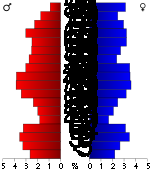
In the county the population was spread out with 22.10% under the age of 18, 5.50% from 18 to 24, 22.90% from 25 to 44, 24.20% from 45 to 64, and 25.30% who were 65 years of age or older. The median age was 45 years. For every 100 females there were 94.40 males. For every 100 females age 18 and over, there were 90.60 males.
The median income for a household in the county was $31,268, and the median income for a family was $38,821. Males had a median income of $25,408 versus $20,307 for females. The per capita income
for the county was $18,033. About 6.70% of families and 9.70% of the population were below the poverty line, including 12.50% of those under age 18 and 9.90% of those age 65 or over.
. None of the cities within the county are considered governmentally independent, and all figures for the townships include those of the cities. In the following table, the population center is the largest city (or cities) included in that township's population total, if it is of a significant size.
Historical
Maps
U.S. state
A U.S. state is any one of the 50 federated states of the United States of America that share sovereignty with the federal government. Because of this shared sovereignty, an American is a citizen both of the federal entity and of his or her state of domicile. Four states use the official title of...
of Kansas
Kansas
Kansas is a US state located in the Midwestern United States. It is named after the Kansas River which flows through it, which in turn was named after the Kansa Native American tribe, which inhabited the area. The tribe's name is often said to mean "people of the wind" or "people of the south...
. As of the 2010 census, the county population was 3,307. The largest city and county seat
County seat
A county seat is an administrative center, or seat of government, for a county or civil parish. The term is primarily used in the United States....
is La Crosse
La Crosse, Kansas
La Crosse is a city in and the county seat of Rush County, Kansas, United States. As of the 2010 census, the city population was 1,342.-History:...
.
Law and government
Rush County was a prohibition, or "dry"Dry county
A dry county is a county in the United States whose government forbids the sale of alcoholic beverages. Some prohibit off-premises sale, some prohibit on-premises sale, and some prohibit both. Hundreds of dry counties exist across the United States, almost all of them in the South...
, county until the Kansas Constitution was amended in 1986 and voters approved the sale of alcoholic liquor by the individual drink with a 30% food sales requirement.
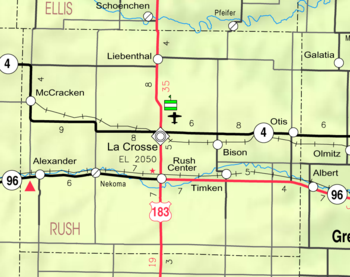
Geography
According to the 2000 census, the county has a total area of 718.42 square miles (1,860.7 km²), of which 718.21 square miles (1,860.2 km²) (or 99.97%) is land and 0.21 square mile (0.5438975031 km²) (or 0.03%) is water.Adjacent counties
- Ellis CountyEllis County, KansasEllis County is a county located in Northwest Kansas, in the Central United States. As of the 2010 census, the county population was 28,452. Its county seat and most populous city is Hays...
(north) - Russell CountyRussell County, KansasRussell County is a county located in the U.S. state of Kansas. The county's population was 6,970 for the 2010 census...
(northeast) - Barton CountyBarton County, KansasBarton County is a county located in Western Kansas, in the Central United States. As of the 2010 census, the county population was 27,674. Its county seat and most populous city is Great Bend. The county is named in honor of Clara Barton, responsible for the founding of the American Red Cross...
(east) - Pawnee CountyPawnee County, KansasPawnee County is a county located in the U.S. state of Kansas. As of the 2010 census, the county population was 6,973...
(south) - Ness CountyNess County, KansasNess County is a county located in the U.S. state of Kansas. As of the 2010 census, the county population was 3,107. The largest city and county seat is Ness City. Ness County was named for Corporal Noah V. Ness of the 7th Kansas Cavalry...
(west)
Demographics
Census
A census is the procedure of systematically acquiring and recording information about the members of a given population. It is a regularly occurring and official count of a particular population. The term is used mostly in connection with national population and housing censuses; other common...
of 2000, there were 3,551 people, 1,548 households, and 1,013 families residing in the county. The population density
Population density
Population density is a measurement of population per unit area or unit volume. It is frequently applied to living organisms, and particularly to humans...
was 5 people per square mile (2/km²). There were 1,928 housing units at an average density of 3 per square mile (1/km²). The racial makeup of the county was 98.45% White
Race (United States Census)
Race and ethnicity in the United States Census, as defined by the Federal Office of Management and Budget and the United States Census Bureau, are self-identification data items in which residents choose the race or races with which they most closely identify, and indicate whether or not they are...
, 0.31% Black
Race (United States Census)
Race and ethnicity in the United States Census, as defined by the Federal Office of Management and Budget and the United States Census Bureau, are self-identification data items in which residents choose the race or races with which they most closely identify, and indicate whether or not they are...
or African American
Race (United States Census)
Race and ethnicity in the United States Census, as defined by the Federal Office of Management and Budget and the United States Census Bureau, are self-identification data items in which residents choose the race or races with which they most closely identify, and indicate whether or not they are...
, 0.42% Native American
Race (United States Census)
Race and ethnicity in the United States Census, as defined by the Federal Office of Management and Budget and the United States Census Bureau, are self-identification data items in which residents choose the race or races with which they most closely identify, and indicate whether or not they are...
, 0.11% Asian
Race (United States Census)
Race and ethnicity in the United States Census, as defined by the Federal Office of Management and Budget and the United States Census Bureau, are self-identification data items in which residents choose the race or races with which they most closely identify, and indicate whether or not they are...
, 0.17% from other races
Race (United States Census)
Race and ethnicity in the United States Census, as defined by the Federal Office of Management and Budget and the United States Census Bureau, are self-identification data items in which residents choose the race or races with which they most closely identify, and indicate whether or not they are...
, and 0.54% from two or more races. 1.04% of the population were Hispanic
Race (United States Census)
Race and ethnicity in the United States Census, as defined by the Federal Office of Management and Budget and the United States Census Bureau, are self-identification data items in which residents choose the race or races with which they most closely identify, and indicate whether or not they are...
or Latino
Race (United States Census)
Race and ethnicity in the United States Census, as defined by the Federal Office of Management and Budget and the United States Census Bureau, are self-identification data items in which residents choose the race or races with which they most closely identify, and indicate whether or not they are...
of any race.
There were 1,548 households out of which 26.60% had children under the age of 18 living with them, 56.10% were married couples
Marriage
Marriage is a social union or legal contract between people that creates kinship. It is an institution in which interpersonal relationships, usually intimate and sexual, are acknowledged in a variety of ways, depending on the culture or subculture in which it is found...
living together, 5.80% had a female householder with no husband present, and 34.50% were non-families. 31.70% of all households were made up of individuals and 18.00% had someone living alone who was 65 years of age or older. The average household size was 2.24 and the average family size was 2.80.
In the county the population was spread out with 22.10% under the age of 18, 5.50% from 18 to 24, 22.90% from 25 to 44, 24.20% from 45 to 64, and 25.30% who were 65 years of age or older. The median age was 45 years. For every 100 females there were 94.40 males. For every 100 females age 18 and over, there were 90.60 males.
The median income for a household in the county was $31,268, and the median income for a family was $38,821. Males had a median income of $25,408 versus $20,307 for females. The per capita income
Per capita income
Per capita income or income per person is a measure of mean income within an economic aggregate, such as a country or city. It is calculated by taking a measure of all sources of income in the aggregate and dividing it by the total population...
for the county was $18,033. About 6.70% of families and 9.70% of the population were below the poverty line, including 12.50% of those under age 18 and 9.90% of those age 65 or over.
Incorporated cities
Name and population (2004 estimate):- La CrosseLa Crosse, KansasLa Crosse is a city in and the county seat of Rush County, Kansas, United States. As of the 2010 census, the city population was 1,342.-History:...
, 1,329 (county seat) - OtisOtis, KansasOtis is a city in Rush County, Kansas, United States. As of the 2010 census, the city population was 282.-Geography:Otis is located at...
, 323 - BisonBison, KansasBison is a city in Rush County, Kansas, United States, named for the native large ungulate of the region. As of the 2010 census, the city population was 255.-Geography:Bison is located at...
, 225 - McCrackenMcCracken, KansasMcCracken is a city in Rush County, Kansas, United States. As of the 2010 census, the city population was 190.-Geography:McCracken is located at . According to the United States Census Bureau, the city has a total area of , all of it land.-Demographics:As of the census of 2000, there were 211...
, 205 - Rush CenterRush Center, KansasRush Center is a city in Rush County, Kansas, United States. As of the 2010 census, the city population was 170.-Geography:Rush Center is located at . According to the United States Census Bureau, the city has a total area of , all of it land.-Demographics:As of the census of 2000, there were...
, 176 - LiebenthalLiebenthal, KansasLiebenthal is a city in Rush County, Kansas, United States. As of the 2010 census, the city population was 103.-Geography:Liebenthal is located at . According to the United States Census Bureau, the city has a total area of , all of it land.-Demographics:As of the census of 2000, there were 111...
, 110 - TimkenTimken, KansasTimken is a city in Rush County, Kansas, United States. As of the 2010 census, the city population was 76.-Geography:Timken is located at . According to the United States Census Bureau, the city has a total area of , all of it land....
, 82 - AlexanderAlexander, KansasAlexander is a city in Rush County, Kansas, United States. As of the 2010 census, the city population was 65.-Geography:Alexander is located at . According to the United States Census Bureau, the city has a total area of , all of it land.-Demographics:As of the census of 2000, there were 75...
, 72
Townships
Rush County is divided into twelve townshipsCivil township
A civil township is a widely used unit of local government in the United States, subordinate to, and geographic divisions of, a county. Specific responsibilities and the degree of autonomy vary based on each state. Civil townships are distinct from survey townships, but in states that have both,...
. None of the cities within the county are considered governmentally independent, and all figures for the townships include those of the cities. In the following table, the population center is the largest city (or cities) included in that township's population total, if it is of a significant size.
| Township | FIPS | Population center |
Population | Population density /km² (/sq mi) |
Land area km² (sq mi) | Water area km² (sq mi) | Water % | Geographic coordinates |
|---|---|---|---|---|---|---|---|---|
| Alexander-Belle Prairie | 01087 | 139 | 1 (2) | 220 (85) | 0 (0) | 0.02% | 38°27′23"N 99°31′49"W | |
| Banner | 04075 | 191 | 1 (4) | 139 (54) | 0 (0) | 0.01% | 38°25′53"N 99°11′28"W | |
| Big Timber | 06775 | 164 | 1 (3) | 122 (47) | 0 (0) | 0.03% | 38°39′1"N 99°18′54"W | |
| Center | 12125 | 256 | 2 (5) | 139 (54) | 0 (0) | 0 % | 38°26′6"N 99°18′13"W | |
| Garfield | 25800 | 132 | 1 (2) | 139 (54) | 0 (0) | 0.01% | 38°25′15"N 99°4′45"W | |
| Hampton-Fairview | 29812 | 304 | 1 (3) | 276 (107) | 0 (0) | 0.11% | 38°37′32"N 99°30′12"W | |
| Illinois | 33750 | 47 | 0 (1) | 125 (48) | 0 (0) | 0.01% | 38°38′48"N 99°11′28"W | |
| La Crosse-Brookdale | 37525 | 1,475 | 7 (17) | 218 (84) | 0 (0) | 0.01% | 38°32′2"N 99°20′15"W | |
| Lone Star | 42500 | 319 | 3 (8) | 110 (42) | 0 (0) | 0 % | 38°31′21"N 99°11′46"W | |
| Pioneer | 55950 | 426 | 4 (10) | 108 (42) | 0 (0) | 0.01% | 38°32′13"N 99°4′4"W | |
| Pleasantdale | 56325 | 33 | 0 (1) | 124 (48) | 0 (0) | 0.07% | 38°38′20"N 99°5′17"W | |
| Union | 72350 | 65 | 0 (1) | 141 (54) | 0 (0) | 0.01% | 38°26′4"N 99°25′47"W |
Unified school districts
Further reading
- History of the State of Kansas; William G. Cutler; A.T. Andreas Publisher; 1883. (Online HTML eBook)
- Kansas : A Cyclopedia of State History, Embracing Events, Institutions, Industries, Counties, Cities, Towns, Prominent Persons, Etc; 3 Volumes; Frank W. Blackmar; Standard Publishing Co; 944 / 955 / 824 pages; 1912. (Volume1 - Download 54MB PDF eBook),(Volume2 - Download 53MB PDF eBook), (Volume3 - Download 33MB PDF eBook)
External links
OfficialHistorical
Maps
- Rush County Map, KDOT
- Kansas Highway Map, KDOT
- Kansas Railroad Map, KDOT
- Kansas School District Boundary Map, KSDE