
Rudolfsheim-Fünfhaus
Encyclopedia
Districts of Vienna
The districts of Vienna are 23 named city sections of Vienna, Austria, which are also numbered for easy reference. For centuries, district boundaries have changed...
, Austria
Austria
Austria , officially the Republic of Austria , is a landlocked country of roughly 8.4 million people in Central Europe. It is bordered by the Czech Republic and Germany to the north, Slovakia and Hungary to the east, Slovenia and Italy to the south, and Switzerland and Liechtenstein to the...
(German
German language
German is a West Germanic language, related to and classified alongside English and Dutch. With an estimated 90 – 98 million native speakers, German is one of the world's major languages and is the most widely-spoken first language in the European Union....
: 15. Bezirk). It is in central Vienna, west of Innere Stadt
Innere Stadt
The Innere Stadt is the 1st municipal District of Vienna . The Innere Stadt is the old town of Vienna. Until the city boundaries were expanded in 1850, the Innere Stadt was congruent with the city of Vienna...
.
It borders Neubau
Neubau
Neubau is the seventh district of Vienna . It is located near the center of Vienna and was established as a district in 1850, but borders changed later...
and Mariahilf
Mariahilf
Mariahilf is the 6th municipal district of Vienna, Austria . It is near the center of Vienna and was established as a district in 1850. Mariahilf is a heavily populated urban area with many residential buildings....
in the east, Meidling
Meidling
Meidling is the 12th district of Vienna . It is located just southwest of the central districts, south of the Wienfluss, west of the Gürtel belt, and east and southeast of Schönbrunn palace...
and Hietzing
Hietzing
Hietzing is the 13th municipal District of Vienna . It is located west of the central districts, west of Meidling...
in the south, Penzing
Penzing (Vienna)
Penzing is the 14th District of Vienna and consists of the boroughs of Penzing, Breitensee, Baumgarten, Hütteldorf and Hadersdorf-Weidlingau. In the west, it shares a border with Purkersdorf and Mauerbach...
in the west, and Ottakring
Ottakring
Ottakring is the 16th District in the city of Vienna, Austria . It is located west of the central districts, north of Penzing and south of Hernals. Ottakring has some heavily populated urban areas with many residential buildings...
in the north. The northern border runs along the Gablenzgasse and eastern border along the Gürtel
Gürtel, Vienna
The Gürtel is a substantial city ring road of Vienna. Running parallel to the famous Ringstraße it encompasses the inner city districts .The road is officially called B 221 Wiener Gürtel Straße...
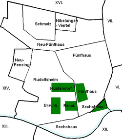
beltway (Neubaugürtel, Mariahilfer Gürtel and Sechshauser Gürtel). It includes the areas of Rudolfsheim (divided into Braunhirschen, Reindorf and Rustendorf), Fünfhaus and Sechshaus.
Topography
The district area of Rudolfsheim-Fünfhaus was, during the Mesozoic Era, near a sea that retreated 70 million years ago and gradually formed an inland sea. After the final retreat of the sea occurred during the Ice Age, large masses of debris formed from glacierGlacier
A glacier is a large persistent body of ice that forms where the accumulation of snow exceeds its ablation over many years, often centuries. At least 0.1 km² in area and 50 m thick, but often much larger, a glacier slowly deforms and flows due to stresses induced by its weight...
s, mainly from the Danube, but also the Vienna River in the Vienna Basin. In the warm phase, the Danube and Vienna River cut into the land and formed gravel terraces, with the older terraces being at increasing distance from the waters. Rudolfsheim-Fünfhaus is located in the oldest terrace (Laaerbergterrasse) supported by Laaerberg on Gloriette from the melting of the Turks and hill ranges. In this section, the terrace Wiental lies, which was once covered by the melting to Gloriette. Through the ever-receding water levels, the height sections remained for the current district area.
The top soil layer in the district territory consists of a thin layer of loess
Loess
Loess is an aeolian sediment formed by the accumulation of wind-blown silt, typically in the 20–50 micrometre size range, twenty percent or less clay and the balance equal parts sand and silt that are loosely cemented by calcium carbonate...
, which is mixed with limestone and sandstone gravel from the Vienna Woods. Among them are layers of river gravel, mainly quartz, coming from the Alps. Below this gravel are the relics of the freshwater sea that a layer of sand, gravel and Tegel deposited. The district area rises from south to north and from east to west. The lowest area of the district territory is located at the intersection of Sechshauser Belt and Ullmannstraße with an elevation of 184 metres (603.7 ft). The highest point is at the crossing John Street and Road Hütteldorfer with an elevation of 240.6 metres (789.4 ft).
Waters
The Vienna River was, in prehistoric times, several hundred meters (a half-mile) wide, and in the Roman period, it was still a wide river with many islands. Even in the Middle Ages and in modern times, the Vienna River has played a dominant role for centuries. On the one hand, the river and its floods repeatedly caused heavy destruction. On the other hand, the river served many people as a source of income, both by fishing, as well as the use of water for industry or the operation of the many watermillWatermill
A watermill is a structure that uses a water wheel or turbine to drive a mechanical process such as flour, lumber or textile production, or metal shaping .- History :...
s. The largest river branch, Mühlbach, followed along Ullmannstraße and Mollardgasse streets. Even smaller streams, which emptied into the Vienna River, were originally in the district area. Today canalised Hollerbach has established itself as a corridor, receiving the name "Hollergasse" lane.
District parts
Over time, the district was extended in addition to parts of Gaudenzdorf (between Wienzeile and Diefenbachgasse) and Penzing (between Hollergasse and Winckelmann Street). Sechshaus is located in the southeast between Hollergasse, Sechshauser Straße and Diefenbachgasse. Rudolfsheim is located in the southwest area of the district, Fünfhaus east of it, the origin was in the area Clementinengasse on a path between Gumpendorf and Schmelz. The border between Rudolfsheim and Fünfhaus run along the line Pouthongasse - Schmelzbrücken Ramp - Grenzgasse - Geibelgasse. Originally, Fünfhaus included the area between Mariahilfer Straße, Kenyongasse, and Wimbergergasse Burggasse, but it was released in 1907 on new construction.
The former municipalities of Rudolfsheim and Fünfhaus are also divided into different district parts. Rudolfsheim was formed from the municipalities Rustendorf, Braunhirschen and Reindorf, whose centers were south of Mariahilfer Street. The northern part of Fünfhaus, north from Hütteldorfer road, divided in turn into Schmelz with the University Sports Institute and the Kleingarten area, the adjacent east Nibelungen quarter and the area of Neu-Fünfhaus, which encloses the two regions.
A breakdown of the district area is also in the census-district official statistics, in which the municipality counts are combined. The seven census-districts in Rudolfsheim-Fünfhaus are: Stadthalle, Reithofferplatz, Fünfhaus-Westbahnhof, Sechshaus, Rudolfsheim-Braunhirschen, Rauscherplatz and Schmelz.
Land use
The developed area of Rudolfsheim-Fünfhaus comprises 52.8% (Vienna city-wide 33.3%) of the District area. Nearly 81.0% of the developed area is accounted for by residences, bringing the district in the upper part of the Vienna districts. Farmland includes a share of 8.2% of the area. Cultural, religious, sporting or public buildings share 10.6% of the area. Nearly 33.5% of the district is in traffic/transportation areas. This is the third highest value of a municipality of Vienna.By contrast, the proportion of grassland in the district is rather small: 12.7%. About half of the green areas are parks, 31.2% attributable to small gardens, with 18.5% as outdoor sports and recreation areas. A final 1.0% is water, i.e. the river bed of the Vienna River.
| Builtspace | Greenspace | Water | Transport areas | |||||||
| 204.04 | 49.16 | 3.68 | 129.46 | |||||||
|---|---|---|---|---|---|---|---|---|---|---|
| Residences | Oper- ations |
Public Facilities | Farms | Parks | Forests | Meadows | Small gardens | Rec. Recreation Recreation is an activity of leisure, leisure being discretionary time. The "need to do something for recreation" is an essential element of human biology and psychology. Recreational activities are often done for enjoyment, amusement, or pleasure and are considered to be "fun"... areas |
||
| 165.35 | 16.62 | 21.59 | 31.7 | 24.5 | 0 | 15.34 | 0.21 | 9.11 | ||
History
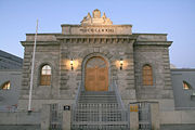
Battle of Vienna
The Battle of Vienna took place on 11 and 12 September 1683 after Vienna had been besieged by the Ottoman Empire for two months...
, the villages of Reindorf, Braunhirschen, and Rustendorf arose and were in 1863 combined into the municipality of Rudolfsheim, named after the Crown Prince Rudolf of Austria
Crown Prince Rudolf of Austria
Rudolf , archduke of Austria and crown prince of Austria, Hungary and Bohemia, was the son and heir of Franz Joseph I, emperor of Austria, Hungary and Bohemia, and his wife and empress, Elisabeth...
. In the nineteenth century, the district grew significantly, and in 1890 was incorporated along with nearby communities Fünfhaus and Sechshaus into Vienna proper. The northern and eastern parts of Fünfhaus became the fifteenth district and the area of Rudolfsheim and Sechshaus became the fourteenth district under the name of Rudolfsheim alone. In 1938 Rudolfsheim and Fünfhaus were unified into the 15th district, and the 14th district became the part of the 13th district north of the Wien River
Wien River
The Wien is a river that flows through the city of Vienna. It is 34 kilometres long , of which 15 km are within the city. Its drainage basin covers an area of 230 km² , both in the city and in the neighbouring Wienerwald....
. Since 1957, the 15th district has been named Rudolfsheim-Fünfhaus.
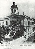
From 1871 to 1938, there had been the synagogue
Synagogue
A synagogue is a Jewish house of prayer. This use of the Greek term synagogue originates in the Septuagint where it sometimes translates the Hebrew word for assembly, kahal...
on Turner Street, but during the November Pogrom Kristallnacht
Kristallnacht
Kristallnacht, also referred to as the Night of Broken Glass, and also Reichskristallnacht, Pogromnacht, and Novemberpogrome, was a pogrom or series of attacks against Jews throughout Nazi Germany and parts of Austria on 9–10 November 1938.Jewish homes were ransacked, as were shops, towns and...
, it was destroyed, along with 91 other Viennese synagogues. Only the City Temple in the 1st District survived the night unscathed.
In the 1990s, there were several small changes in district boundaries. In 1992, the boundaries were altered in the area of the Auer-Welsbach Park.
In 1995, the district boundaries changed in two sections of the belt,
and in the field Kendlerstraße, Sporckplatz and Ibsenstraße.
The most recent change was marginal in 1996 in the area of Europe square in front of the Western Railway Station.
These border changes were not in residential areas, but especially at transport buildings, parks and sports facilities.
Population
Data from Statistik Austria http://www.statistik.at/blickgem/vz1/g92001.pdf https://www.wien.gv.at/statistik/pdf/bezirksportraets08.pdf |
Population development
In 1869, the current area covered by the Rudolfsheim-Fünfhaus district already included 64,042 inhabitants, and it was similarly densely populated as it is today. Through the continuous influx of people into the area, the population increased until the beginning of the Great War, and had doubled by 1910 at the peak of 145,694 people. Afterwards, a permanent population decline occurred, which was mainly due to higher housing claims. After a historic low of 64,895 inhabitants in 2001, the district population trended to re-grow. Only after the turn of the millennium, did the population in Vienna city-wide tend to grow. At the beginning of 2007, the population stood at 70,490 people in Rudolfsheim-Fünfhaus.Population structure
The age structure of the district population in 2001 was slightly younger than the average across Vienna. The number of children under 15 years was 15.3%, slightly higher than for Vienna city-wide (14.7%). The proportion of the population from 15 to 59 years stood at 65.8% (Vienna: 63.6%), with the proportion of people over the age of 60 as 19.0% (Vienna: 21.7%), significantly lower than the whole city. The gender distribution was in the district area at 48.2% men and 51.8% women.The number of married people had a share of 40.6%, compared with city-wide at 41.2%, slightly below the average of Vienna.
Origin and language
The proportion of foreign district residents in 2006 was 31.8% (Vienna: 19.1%) and was the highest value of a district of Vienna.As in the entire state, the percentage growth to 2001, he worked for 29.2%. The highest proportion of foreigners in 2005 represented approximately 9.6% share of the district population as nationals from Serbia
Serbia
Serbia , officially the Republic of Serbia , is a landlocked country located at the crossroads of Central and Southeast Europe, covering the southern part of the Carpathian basin and the central part of the Balkans...
and Montenegro
Montenegro
Montenegro Montenegrin: Crna Gora Црна Гора , meaning "Black Mountain") is a country located in Southeastern Europe. It has a coast on the Adriatic Sea to the south-west and is bordered by Croatia to the west, Bosnia and Herzegovina to the northwest, Serbia to the northeast and Albania to the...
. Another 4.7% were Turkish
Turkey
Turkey , known officially as the Republic of Turkey , is a Eurasian country located in Western Asia and in East Thrace in Southeastern Europe...
, 2.5% Polish
Poland
Poland , officially the Republic of Poland , is a country in Central Europe bordered by Germany to the west; the Czech Republic and Slovakia to the south; Ukraine, Belarus and Lithuania to the east; and the Baltic Sea and Kaliningrad Oblast, a Russian exclave, to the north...
, 2.3% Croatia
Croatia
Croatia , officially the Republic of Croatia , is a unitary democratic parliamentary republic in Europe at the crossroads of the Mitteleuropa, the Balkans, and the Mediterranean. Its capital and largest city is Zagreb. The country is divided into 20 counties and the city of Zagreb. Croatia covers ...
n, 2.2% Bosnian
Bosnia and Herzegovina
Bosnia and Herzegovina , sometimes called Bosnia-Herzegovina or simply Bosnia, is a country in Southern Europe, on the Balkan Peninsula. Bordered by Croatia to the north, west and south, Serbia to the east, and Montenegro to the southeast, Bosnia and Herzegovina is almost landlocked, except for the...
and 1.1% German
Germany
Germany , officially the Federal Republic of Germany , is a federal parliamentary republic in Europe. The country consists of 16 states while the capital and largest city is Berlin. Germany covers an area of 357,021 km2 and has a largely temperate seasonal climate...
citizen. In 2001, nearly 35.2% of the district population was born in Austria. Almost 13.0% stated as a language Serbian
Serbian language
Serbian is a form of Serbo-Croatian, a South Slavic language, spoken by Serbs in Serbia, Bosnia and Herzegovina, Montenegro, Croatia and neighbouring countries....
, 8.7% Turkish
Turkish language
Turkish is a language spoken as a native language by over 83 million people worldwide, making it the most commonly spoken of the Turkic languages. Its speakers are located predominantly in Turkey and Northern Cyprus with smaller groups in Iraq, Greece, Bulgaria, the Republic of Macedonia, Kosovo,...
and 5.4% Croatian
Croatian language
Croatian is the collective name for the standard language and dialects spoken by Croats, principally in Croatia, Bosnia and Herzegovina, the Serbian province of Vojvodina and other neighbouring countries...
.
Religious preferences
Due to the high proportion of foreigners, Rudolfsheim- has the lowest (40.2%) Roman CatholicRoman Catholic Church
The Catholic Church, also known as the Roman Catholic Church, is the world's largest Christian church, with over a billion members. Led by the Pope, it defines its mission as spreading the gospel of Jesus Christ, administering the sacraments and exercising charity...
population share of a district in Vienna (Vienna: 49.2%). There are seven district Roman Catholic parishes, forming the City Deanery 15. The proportion of people with Islam
Islam
Islam . The most common are and . : Arabic pronunciation varies regionally. The first vowel ranges from ~~. The second vowel ranges from ~~~...
and Orthodox faiths reached 14.7% and 11.4%, the highest values in Vienna. The proportion of Protestant
Evangelical Church
The term Evangelical Church may refer specifically to:* Slovak Evangelical Church* Armenian Evangelical Church* Assyrian Evangelical Church* Christian Evangelical Church of Romania* Ethiopian Evangelical Church Mekane Yesus...
residents stood at 3.1%, below the average. Almost 23.3% of the district population in 2001 were not included in a religious community. Another 7.4% had none or some other religious preference given.
Politics
| Johann Klugmayer (KPÖ KPO Meanings of KPO:* Knowledge process outsourcing.* KPÖ , Communist Party of Austria.* Kommunistische Partei Deutschlands , Communist Party Opposition.... ) |
1945–1946 |
| Heinrich Hajek (SPÖ SPO - Technology :SPO: Microsoft SharePoint Online, Microsoft Cloud Computing, Office 365. See Microsoft Online Services-Economics:* Secondary Public Offering, an equity capital market instrument... ) |
1946–1963 |
| Maximilian Eder (SPÖ SPO - Technology :SPO: Microsoft SharePoint Online, Microsoft Cloud Computing, Office 365. See Microsoft Online Services-Economics:* Secondary Public Offering, an equity capital market instrument... ) |
1968–1985 |
| Kurt Menger (SPÖ SPO - Technology :SPO: Microsoft SharePoint Online, Microsoft Cloud Computing, Office 365. See Microsoft Online Services-Economics:* Secondary Public Offering, an equity capital market instrument... ) |
1985–1990 |
| Friedrich Krammer (SPÖ SPO - Technology :SPO: Microsoft SharePoint Online, Microsoft Cloud Computing, Office 365. See Microsoft Online Services-Economics:* Secondary Public Offering, an equity capital market instrument... ) |
1990–1996 |
| Rolf Huber (SPÖ SPO - Technology :SPO: Microsoft SharePoint Online, Microsoft Cloud Computing, Office 365. See Microsoft Online Services-Economics:* Secondary Public Offering, an equity capital market instrument... ) |
1996–2003 |
| Walter Braun (SPÖ SPO - Technology :SPO: Microsoft SharePoint Online, Microsoft Cloud Computing, Office 365. See Microsoft Online Services-Economics:* Secondary Public Offering, an equity capital market instrument... ) |
2003–2008 |
| Gerhard Zatlokal (SPÖ SPO - Technology :SPO: Microsoft SharePoint Online, Microsoft Cloud Computing, Office 365. See Microsoft Online Services-Economics:* Secondary Public Offering, an equity capital market instrument... ) |
2008– |
The SPÖ in Rudolfsheim-Fünfhaus has always been a strong majority and selected throughout the district governor. For a long time, the Social Democrats have governed in the district, with total votes or a majority mandate. In the elections of 1991, for the first time the rising FPÖ could overtake ÖVP, traditionally the second largest party in the district, with the highest proportion of foreigners. In 1996, the FPÖ, with the best result in a district of Vienna, broke the absolute-majority mandate of the SPÖ. In the elections in 2001, however, the FPÖ lost votes heavily, and even fell behind the result of 1991. From the losses, the SPÖ and the Greens benefitted. The SPÖ reached around 47% of the votes again (see chart below), a result close to the absolute majority of votes. The Greens increased by 14% for the third-force, and could overtake the ÖVP (as 4th). In 2005, the trend continued. The SPÖ won easily and reached 49%; the Greens overtook FPÖ with about 18% and increased the second-largest party, which traditionally provides a district deputy chief. The ÖVP was in 2005 only the 4th largest party, with its share of votes continuing to stagnate.
| Jahr | SPÖ | ÖVP | FPÖ | Grüne | LIF | Sonstige |
| 1991 | 49.9 | 15.5 | 23.9 | 8.2 | n.k | 2.5 |
| 1996 | 38.1 | 12.6 | 32.3 | 9.1 | 5.6 | 2.3 |
| 2001 | 47.3 | 12.9 | 22.0 | 14.4 | 2.6 | 0.9 |
| 2005 | 49.5 | 13.5 | 16.1 | 17.6 | 0.5 | 2.8 |
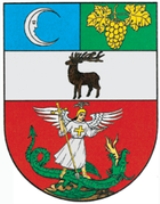
Coat of Arms (Crest)
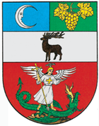
The red section stands for the former villages of Fünfhaus and Sechshaus. It shows the Archangel Michael in a silver and a golden robe, with ostrich feathers in the helmet. Michael holds in his hand a golden cross lance with which he kills a green fire-breathing dragon. The presentation here symbolizes the Barnabitenkollegium St. Michael in Vienna, the founding fathers of the settlements of Fünfhaus and Sechshaus. As the former crest of Sechshaus was virtually identical to Fünfhaus, it is represented in the Fünfhaus portion of the crest.
External links
- Rudolfsheim-Fünfhaus at website wien.at (German).
- Bezirksmuseum Rudolsheim-Fünfhaus - District museum (German).