
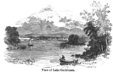
Lake Cochituate
Encyclopedia
Lake Cochituate is a body of water in Natick
, Wayland
, and Framingham
, Massachusetts
. Originally a reservoir serving Boston, it no longer serves that function, and is now a local recreational resource and home to Cochituate State Park
.
in South Pond is the site of the US Army Soldier Systems Center, and the eastern shore holds the trails of Pegan Cove Park. Middle Pond is home to Cochituate State Park
, which includes boat ramps and a picnic area. North Pond is the site of both Wayland Town Beach and Saxonville Beach of Framingham.
On the edge of the Middle Pond, is the corporate headquarters of Boston Scientific
. This building was originally a Carling
Brewery, built in 1957. A partially deconstructed freight train track runs alongside sections of the lake, which brought supplies to both the Carling Brewery, the ITT Continental Bakery, and a Green Stamps warehouse located on the edge of the lake in an area formerly called an Industrial Park. A proposed rail trail
will run along the lake on this track's right-of-way, from downtown Natick to Saxonville, a section of Framingham.
The three ponds and their connector ponds are together 625 acres (2.5 km²). South of Cochituate, the 40 acres (161,874.4 m²) Dug Pond
is the site of Natick High School
. The Lake Cochituate Watershed, part of the Sudbury River
Watershed encompasses 17 square miles (44 km²) in Natick, Wayland, Framingham, Ashland
, and Sherborn
. This in turn is part of the Concord River
and Merrimack River
watersheds. Cochituate
is also the name of a village in Wayland.
 Lake Cochituate was created by the construction of Lake Cochituate Dam
to provide a reservoir for water supply to the City of Boston, via the 14 miles (22.5 km) Cochituate Aqueduct
. Lake Cochituate was the first major water supply system built for the city, and replaced the previous usage of Jamaica Pond
. Developed from 1848 to 1863, it supplied Boston's water until 1951, when it was replaced by the larger Wachusett
and Quabbin Reservoir
s. The surveys and plans for the project were performed by American civil engineer James Fowle Baldwin
(1782–1862), the son of Loammi Baldwin
who designed the Middlesex Canal
, and younger brother of Loammi Baldwin, Jr.
(1780–1838) who authored the earlier studies for a Boston water supply. The dam, located on the lake's former northwestern outlet, formed the headworks
of the water supply system, and is now listed on the National Register of Historic Places
.
A solvent-contamination plume is in the groundwater below Building 36. Monitoring well testing found chlorinated solvents leaking from underground into two portions of the Lake Cochituate shoreline. Sensitive tests have detected these solvents in lake waters and sediments.
Polychlorinated Biphenyls (PCBs) in Lake Cochituate and Pegan Cove
PCBs have been found at the Natick labs in soils and in lake sediments near Kansas Street and the T-25 outfall, likely caused in part by a PCB transformer explosion in 1984.
Ecological toxicity testing found that lake sediments were toxic to aquatic life. Oxygen-poor conditions in the sediments were also factor. Bluegill, bass, and eels all show PCB contamination near the Army Labs, at levels up to and greater than 5000 parts per billion. Animals (including people) eating these fish would ingest enough PCBs to be harmed. A review of Massachusetts Fish and Wildlife data showed that Lake Cochituate fish have PCB levels up to 180 times higher than the statewide average.
A warning against eating Bass and Eels is in effect for Lake Cochituate due to PCB contamination.
Fish from Natick's Lake Cochituate should not be eaten due to the proven PCB contamination. No PCB clean up is planned because the Army assumes that no one is eating more than 1/3 of an ounce of de-skinned lake fish fillet per day. Those who eat more fish, or any amount of eels, or unskinned fish will receive higher exposures to PCBs. The Army determined that Natick's animal populations were large enough to absorb the deaths of the animals which forage around the Natick Labs. Read more
The Army added three new monitoring wells to the area between the Labs and the Town of Natick drinking water wells beside Route 9 (Worcester Road) near Boston Scientific. These wells will improve the odds of detecting chemicals as they are drawn into the Town's water supply wells.
Natick, Massachusetts
Natick is a town in Middlesex County, Massachusetts, United States. Natick is located near the center of the MetroWest region of Massachusetts, with a population of 33,006 at the 2010 census. Only west from Boston, Natick is considered part of the Greater Boston area...
, Wayland
Wayland, Massachusetts
Wayland is a town in Middlesex County, Massachusetts, United States. The population was 12,994 at the 2010 census.For geographic and demographic information on Cochituate, which is part of Wayland, please see the article Cochituate, Massachusetts.-History:...
, and Framingham
Framingham, Massachusetts
Framingham is a New England town in Middlesex County, Massachusetts, United States. The population was 68,318 as of the United States 2010 Census. -History:...
, Massachusetts
Massachusetts
The Commonwealth of Massachusetts is a state in the New England region of the northeastern United States of America. It is bordered by Rhode Island and Connecticut to the south, New York to the west, and Vermont and New Hampshire to the north; at its east lies the Atlantic Ocean. As of the 2010...
. Originally a reservoir serving Boston, it no longer serves that function, and is now a local recreational resource and home to Cochituate State Park
Cochituate State Park
Cochituate State Park is a Massachusetts state park located in Natick. The park is managed by the Department of Conservation and Recreation.-Description:...
.
Description
Lake Cochituate consists of three linked ponds known as North Pond, Middle Pond, and South Pond. A large peninsulaPeninsula
A peninsula is a piece of land that is bordered by water on three sides but connected to mainland. In many Germanic and Celtic languages and also in Baltic, Slavic and Hungarian, peninsulas are called "half-islands"....
in South Pond is the site of the US Army Soldier Systems Center, and the eastern shore holds the trails of Pegan Cove Park. Middle Pond is home to Cochituate State Park
Cochituate State Park
Cochituate State Park is a Massachusetts state park located in Natick. The park is managed by the Department of Conservation and Recreation.-Description:...
, which includes boat ramps and a picnic area. North Pond is the site of both Wayland Town Beach and Saxonville Beach of Framingham.
On the edge of the Middle Pond, is the corporate headquarters of Boston Scientific
Boston Scientific
The Boston Scientific Corporation , is a worldwide developer, manufacturer and marketer of medical devices whose products are used in a range of interventional medical specialties, including interventional cardiology, peripheral interventions, neuromodulation, neurovascular intervention,...
. This building was originally a Carling
Carling
Carling brands are currently owned by the Molson Coors Brewing Company. In South Africa it is distributed by SABMiller.Carling Black Label is the name of a brand of Canadian lager in Australia, Canada, Ireland, the United Kingdom and South Africa...
Brewery, built in 1957. A partially deconstructed freight train track runs alongside sections of the lake, which brought supplies to both the Carling Brewery, the ITT Continental Bakery, and a Green Stamps warehouse located on the edge of the lake in an area formerly called an Industrial Park. A proposed rail trail
Rail trail
A rail trail is the conversion of a disused railway easement into a multi-use path, typically for walking, cycling and sometimes horse riding. The characteristics of former tracks—flat, long, frequently running through historical areas—are appealing for various development. The term sometimes also...
will run along the lake on this track's right-of-way, from downtown Natick to Saxonville, a section of Framingham.
The three ponds and their connector ponds are together 625 acres (2.5 km²). South of Cochituate, the 40 acres (161,874.4 m²) Dug Pond
Dug Pond
Dug Pond is a small body of water in Natick, Massachusetts. Most notably it is home to Memorial Beach, one of few swimming beaches in Natick, and its eastern shore is the site of Natick High School.-Uses:...
is the site of Natick High School
Natick High School
Natick High School is a public high school serving students in grades 9-12 in Natick, Massachusetts. The school is located on the banks of Lake Cochituate. It enrolled 1189 students as of the 2005-06 school year. Rose Bertucci is currently the interim principal after the retirement of former...
. The Lake Cochituate Watershed, part of the Sudbury River
Sudbury River
The Sudbury River is a tributary of the Concord River in Middlesex County, Massachusetts, in the United States.Originating in the Cedar Swamp in Westborough, Massachusetts, near the boundary with Hopkinton, it meanders generally northeast to its confluence with the Assabet River at Egg Rock in...
Watershed encompasses 17 square miles (44 km²) in Natick, Wayland, Framingham, Ashland
Ashland, Massachusetts
Ashland is a town in Middlesex County, Massachusetts, United States. It is part of the MetroWest region. The population was 16,593 at the 2010 census.-History:...
, and Sherborn
Sherborn, Massachusetts
Sherborn is a town in Middlesex County, Massachusetts, United States. It is in area code 508 and has the ZIP code 01770. As of the 2010 U.S. Census, the town population was 4,119. The assessed value of the town for the fiscal year 2005 is $1,008,146,994....
. This in turn is part of the Concord River
Concord River
The Concord River is a tributary of the Merrimack River in eastern Massachusetts in the United States. The river drains a small rural and suburban region northwest of Boston. One of the most famous small rivers in U.S...
and Merrimack River
Merrimack River
The Merrimack River is a river in the northeastern United States. It rises at the confluence of the Pemigewasset and Winnipesaukee rivers in Franklin, New Hampshire, flows southward into Massachusetts, and then flows northeast until it empties into the Atlantic Ocean at Newburyport...
watersheds. Cochituate
Cochituate, Massachusetts
Cochituate is a census-designated place in the town of Wayland in Middlesex County, Massachusetts, United States. The population was 6,768 at the 2000 census.-Geography:Cochituate is located at ....
is also the name of a village in Wayland.
History
Lake Cochituate Dam
Lake Cochituate Dam is a historic dam on the northwestern side of Lake Cochituate in Framingham, Massachusetts....
to provide a reservoir for water supply to the City of Boston, via the 14 miles (22.5 km) Cochituate Aqueduct
Cochituate Aqueduct
The Cochituate Aqueduct was an aqueduct bringing water to Boston, Massachusetts, during the years 1848-1951.The aqueduct formed a key link in Boston's first major water supply system. Its genesis dates to 1845, when a Sudbury River tributary was impounded to form Lake Cochituate in Natick...
. Lake Cochituate was the first major water supply system built for the city, and replaced the previous usage of Jamaica Pond
Jamaica Pond
Jamaica Pond is a kettle pond, part of the Emerald Necklace of parks in Boston designed by Frederick Law Olmsted. The pond and park are in the Jamaica Plain neighborhood of Boston, close to the border of Brookline...
. Developed from 1848 to 1863, it supplied Boston's water until 1951, when it was replaced by the larger Wachusett
Wachusett Reservoir
The Wachusett Reservoir is the second largest body of water in the state of Massachusetts. It is located in central Massachusetts, northeast of Worcester. It is part of the water supply system for metropolitan Boston maintained by the Massachusetts Water Resources Authority . It has an aggregate...
and Quabbin Reservoir
Quabbin Reservoir
The Quabbin Reservoir is the largest inland body of water in the Commonwealth of Massachusetts and was built between 1930 and 1939. Today along with the Wachusett Reservoir, it is the primary water supply for Boston, some to the east, as well as 40 other communities in Greater Boston...
s. The surveys and plans for the project were performed by American civil engineer James Fowle Baldwin
James Fowle Baldwin
James Fowle Baldwin was an early American civil engineer who worked with his father and brothers on the Middlesex Canal, surveyed and designed the Boston and Lowell Railroad and the Boston and Albany Railroad, the first Boston water supply from Lake Cochituate, and many other early engineering...
(1782–1862), the son of Loammi Baldwin
Loammi Baldwin
Colonel Loammi Baldwin was a noted American engineer, politician, and a soldier in the American Revolutionary War....
who designed the Middlesex Canal
Middlesex Canal
The Middlesex Canal was a 27-mile barge canal connecting the Merrimack River with the port of Boston. When operational it was 30 feet wide, and 3 feet deep, with 20 locks, each 80 feet long and between 10 and 11 feet wide...
, and younger brother of Loammi Baldwin, Jr.
Loammi Baldwin, Jr.
Loammi Baldwin, Jr. was an American civil engineer. His father was Col. Loammi Baldwin a prominent civil engineer.-Biography:...
(1780–1838) who authored the earlier studies for a Boston water supply. The dam, located on the lake's former northwestern outlet, formed the headworks
Headworks
Headworks is a civil engineering term for any structure at the head or diversion point of a waterway. It is smaller than a barrage and is used to divert water from a river into a canal or from a large canal into a smaller canal....
of the water supply system, and is now listed on the National Register of Historic Places
National Register of Historic Places
The National Register of Historic Places is the United States government's official list of districts, sites, buildings, structures, and objects deemed worthy of preservation...
.
Contamination
The Following is a clip from the local "Natick Superfund" website regarding the toxins currently found in Lake Cochituate.A solvent-contamination plume is in the groundwater below Building 36. Monitoring well testing found chlorinated solvents leaking from underground into two portions of the Lake Cochituate shoreline. Sensitive tests have detected these solvents in lake waters and sediments.
Polychlorinated Biphenyls (PCBs) in Lake Cochituate and Pegan Cove
PCBs have been found at the Natick labs in soils and in lake sediments near Kansas Street and the T-25 outfall, likely caused in part by a PCB transformer explosion in 1984.
Ecological toxicity testing found that lake sediments were toxic to aquatic life. Oxygen-poor conditions in the sediments were also factor. Bluegill, bass, and eels all show PCB contamination near the Army Labs, at levels up to and greater than 5000 parts per billion. Animals (including people) eating these fish would ingest enough PCBs to be harmed. A review of Massachusetts Fish and Wildlife data showed that Lake Cochituate fish have PCB levels up to 180 times higher than the statewide average.
A warning against eating Bass and Eels is in effect for Lake Cochituate due to PCB contamination.
Fish from Natick's Lake Cochituate should not be eaten due to the proven PCB contamination. No PCB clean up is planned because the Army assumes that no one is eating more than 1/3 of an ounce of de-skinned lake fish fillet per day. Those who eat more fish, or any amount of eels, or unskinned fish will receive higher exposures to PCBs. The Army determined that Natick's animal populations were large enough to absorb the deaths of the animals which forage around the Natick Labs. Read more
The Army added three new monitoring wells to the area between the Labs and the Town of Natick drinking water wells beside Route 9 (Worcester Road) near Boston Scientific. These wells will improve the odds of detecting chemicals as they are drawn into the Town's water supply wells.
External links
- Old USGS maps of Framingham and Lake Cochituate see 1894 southeast corner.
- 1871 Atlas of Massachusetts. by Wall & Gray. Map of Massachusetts. Map of Middlesex County.