

Route 199-CH
Encyclopedia
Branch line
A branch line is a secondary railway line which branches off a more important through route, usually a main line. A very short branch line may be called a spur line...
road going eastward from Chile Highway 5
Chile Highway 5
Chile Highway 5 or Route 5 known locally as Ruta 5 is Chile's longest route. It is part of the Panamerican Highway.-Stretch:It runs from the Peruvian border connecting with Peru Highway 1 north of Arica to Puerto Montt where it connects by ferry to the island of Chiloé...
near Freire
Freire
Freire is a word used in the Portuguese and Galician languages to define the occupational name for a friar, or a nickname for a pious person or someone employed at a monastery...
to Mamuil Malal Pass
Mamuil Malal Pass
Mamuil Malal Pass is an international mountain pass in the Andes between Chile and Argentina. The pass connects Pucón and Curarrehue in Chile with Junín de los Andes in Argentina. The road is paved on the Argentinian side and passes just north of Lanín Volcano . During winter the pass may close...
at the border to Argentina
Argentina
Argentina , officially the Argentine Republic , is the second largest country in South America by land area, after Brazil. It is constituted as a federation of 23 provinces and an autonomous city, Buenos Aires...
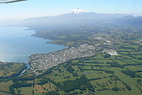
. Through its length the road passes along the cities and towns of Villarrica
Villarrica, Chile
Villarrica is a city and commune in southern Chile located on the western shore of Villarrica Lake in the Province of Cautín, Araucanía Region south of Santiago and close to the Villarrica Volcano ski center to the south east. Residents of Villarrica are known as Villarriquences.Tourism, grain and...
, Pucón
Pucón
Pucón is a Chilean city and commune administered by the municipality of Pucón located in the Province of Cautín, Araucanía Region, 100 km to the southeast of Temuco and 780 km to the south of Santiago....
and Curarrehue
Curarrehue
Curarrehue is a town and commune in Cautín Province of Araucanía Region, Chile. The origin of Curarrehue dates back to the occupation of Araucanía and the Conquest of the Desert by the Chilean and Argentine army respectively in the 1870s and 1880s when Mapuches were pushed by the Argentine Army...
, between the first two cities the road runs along Villarrica Lake following the foothills of Villarrica volcano
Villarrica (volcano)
Villarrica is one of Chile's most active volcanoes, rising above the lake and town of the same name. The volcano is also known as Rucapillán, a Mapuche word meaning "House of the Pillán". It is the westernmost of three large stratovolcanoes that trend perpendicular to the Andean chain along the...
. East of Pucón the road follows Trancura Valley
Trancura River
Trancura River is a river located in the Araucanía Region of Chile. Its headwaters drain the southeasternmost portion of Villarrica National Park, including the northwestern slope of Lanín volcano...
, passing by Curarrehue, until Mamuil Malal Pass just nort of Lanín volcano
Lanín
Lanín is an ice-clad, cone-shaped stratovolcano on the border of Argentina and Chile. It forms part of two national parks: Lanín in Argentina and Villarrica in Chile. It is a symbol of the Argentine province of Neuquén, being part of its flag and its anthem. Although the date of its last eruption...
. In the section south of Curarrehue and before the turn eastwards the road follows the Reigolil-Pirihueico Fault
Reigolil-Pirihueico Fault
The Reigolil-Pirihueico Fault is a second-order geological fault located in the Chilean and Argentine Andes. As the name implies it runs from Pirihueico Lake to Reigolil Valley...
.