
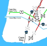
New Jersey Route 162
Encyclopedia
Route 162 is an unsigned 0.7 miles (1.1 km) long state highway
in Lower Township
, New Jersey
, United States
. The highway's designation consists entirely of a bridge on Seashore Road (County Route 626), which is known as Relocated Seashore Road. The southern terminus of the highway is an intersection with County Routes 641 and 626 in Lower Township. After crossing the Cape May Canal
, Route 162 terminates at an intersection with County Routes 603 and 626 in Lower Township. Route 162 and County Route 626 date back to the 1850s, when local businessmen and county financial Richard Holmes put together the Cape May Turnpike. The turnpike was chartered in 1854, but construction did not begin until 1857, with completion in April of the next year. The turnpike however, caused a lot of controversy, and struggled to live. For many years, railroads were proposed, becoming possible competition for Holmes, who did not appreciate the idea. The railroad was constructed in 1863, just nine years after the charter of the turnpike syndicate.
Route S4C was designated by the New Jersey Legislature
in 1929 as a spur of Route 4 (now U.S. Route 9), beginning at Bennett and running south on Seashore Road and Broadway, past Sunset Boulevard to the Delaware Bay
. Route S4C was never taken over by the state. However, when the United States Army Corps of Engineers
built the Cape May Canal
during World War II
, Seashore Road was chosen as one of two roads to cross the canal. (The other was Route 4, now Route 109). The Army Corps built a low level bridge close to the pre-canal alignment. The New Jersey Department of Transportation
built a higher bridge in 1971 on a new alignment.
was a strong business and legal section in Cape May County
. The local residents there, however, wanted to have a strong banking industry, but a local named Richard Holmes along with several other locals turned to the strong type of enterprise, a turnpike company. Holmes and the locals began a local turnpike syndicate with other businessmen and began the Cape May Turnpike Company upon incorporation in 1854. The turnpike company, upon incorporation, was to build a toll road along roughly the U.S. Route 9 corridor. Progress in constructing the toll road was slow at first, with subscribers from Cape May County being hesitant to buy stock from the turnpike company. A friend of Richard Holmes, Wilmon Whilldin, owned a steamboat company in Cape May
and apologized for not buying stock in the company. Citing the Panic of 1857
made it hard to convert securities to cash, Whilldin suggested that a steamboat would be more profitable than the turnpike. The money from the steamboat would go ahead and helped the financially-depressed businesses in local communities.
Although local business owners and land owners held out hope that the turnpike company would pay off, the turnpike experienced problems. Richard Holmes and Henry Swain, the director of the turnpike company, were running into problems including failure to buy land from Elijah Hand's pasture and Samuel Hoffman's local residence for the turnpike route, because they kept land prices high. The farmers refused to the sell their rightful land, and locals started showing opposition due to the fact it would cost money to deliver important foods. One of those locals, John Tomlin from Goshen
, soon after brought up the idea of the "Shunpike
" – a free turnpike road to the west of the Cape May Turnpike. However, the turnpike company kept pushing forward, persuading Hand and Hoffman to sell land in 1857 and erecting two tollhouses in the route, one at the Court House (now Cape May Court House
) and one near Cold Spring. Eventually, locals finally began to move towards support of the turnpike. In April 1858, John Wiley, who helped persuade Hand and Hoffman to sell, announced that in three weeks, the route would be complete as one continuous road from Cape Island to Cape May Court House.
 After completion of the turnpike in April-May 1858, the Cape May Turnpike did not receive much profits. Even with tolls being collected and stock being bought, these could not offset the costs of repairs and maintenance. The roadbed was commonly washed away in storms and it was becoming a less used route as the "Shunpike" (now NJ 162/County Route 626) nearby was free to use, taking away traffic from the turnpike. Walters Miller, a big investor of the turnpike company, decided to leave the syndicate in favor of working towards railroads. Miller himself looked into the construction of railroads in the area, hiring William Cook, who engineered the Camden and Amboy Railroad into producing routes along the peninsula. Cook proposed three routes in 1852, one from the Camden waterfront
to Cape May economic region, one through Millville
and Bridgeton and a third through Salem
. Although the rights for a railroad in the area by the New Jersey General Assembly
had been allowed since 1832, there has been no progress on any railroad in Cape May County until 1863. That year, progress started on constructing the Camden and Atlantic Railroad using the first proposal by Cook in 1852. Jonathan Pitney of Absecon
spent two years trying to obtain the charter from the General Assembly. In a letter to Richard Holmes, Pitney said the chances of getting the railroad charter and building it were "good". Holmes, however, was cautious towards the railroad company investment, showing little thought of having a railroad created that would compete with his struggling turnpike syndicate.
Businessmen in Cape May County believed the economy in the area was still unstable for quite an engineering project. An adviser to Richard Holmes suggested to be careful on future investments that he would take, including investing into the railroad company. The adviser believed that it would be "bad policy" to make such decisions. Debate continued about the railroad line for at least a decade, and the heads of the Camden and Atlantic Railroad put forth a proposal to build a portion of railroad from Absecon to Cape May along the Tuckahoe River
. After attempts to revive the railroad were attempted by several other companies (including the Glassboro and Millville Railroad), the attempts failed. An eventual formation of the Cape May and Millville Railroad in 1860 pushed forward more proposals, and a railroad was constructed in 1863 (and leased in 1869), and the alignment of Seashore Road became part of a stagecoach route from Cold Spring to Cape Island.
just short of Sunset Boulevard (the former Cape Island Turnpike) northward to U.S. Route 9 at Bennett Station via Broadway and Seashore Road was designated in the state legislature as State Highway Route S4C. The route was designated along County Route 626's length along with County Route 604 as a county-maintained highway, remaining the same until January 1, 1953. On that day, State Highway Route S4C was decommissioned during the 1953 New Jersey state highway renumbering
. No number was designated to replace the highway's former number.
During the 1930s and 1940s, the proposal for a canal to supply ships with an evacuation route from Germany
's U-boats in World War II
along with dangerous shoals of the Delaware Bay
came forward. The canal, now the Cape May Canal
, was approved in 1941 and was constructed in 1942 to supply this need along with a strong usage by yachts. By 1944, a bridge was constructed across the canal, which was replaced in 1971. That year, the state built a brand new bridge and denoted it as Relocated Seashore Road, a 485.89 feet (148.1 m) long steel girder bridge over the Canal. The bridge was built south of U.S. Route 9 and has stood since and received the designation of Route 162 upon completion.
. The route heads northward through the residential portions of Cape May, continuing for several blocks before curving to the northwest into West Cape May
. The route heads northward, passing into a commercial district along Broadway, turning to the northeast. Route 626 leaves West Cape May and switches names to Seashore Road through rural Cape May. The route passes several large farms before intersecting with Bridge Road and Seashore Road (County Route 641). At this intersection, the state takes over maintenance as State Route 162.
maintains the alignment of County Route 626 from this intersection over the Relocated Seashore Road Bridge. The route heads northward from County Route 641, paralleling both roads as it heads up the bridge approach and following the shoreline. From there, Route 162 reaches the Cape May Canal
, crossing on the four-lane Relocated Seashore Road Bridge for a short distance. The route returns to land on the other side of the canal, where more farms and residences can be seen from the bridge. Route 162 curves to the northwest, intersecting with Seashore Road (County Route 603). At that intersection, Cape May County resumes maintenance of Seashore Road, continuing as County Route 626.
, paralleling U.S. Route 9 and a local railroad for some distance. The highway intersects with the Old Stage Road, a dead-end stagecoach road, heading through a short rural area before returning to the residential districts. The highway continues northward, switch names to South Railroad Avenue and into the community of Rio Grande
. County Route 626 becomes a divided highway before reaching an intersection with New Jersey Route 47, where county maintenance ends completely. North Railroad Avenue continues locally along the right-of-way.
| colspan="7" style="text-align:center;"|State Route 162 begins at County Route 641
|-
|-
| colspan="7" style="text-align:center;"|State Route 162 ends at County Route 603
|-
State highway
State highway, state road or state route can refer to one of three related concepts, two of them related to a state or provincial government in a country that is divided into states or provinces :#A...
in Lower Township
Lower Township, New Jersey
Lower Township is a township in Cape May County, New Jersey, United States. It is part of the Ocean City Metropolitan Statistical Area. As of the United States 2000 Census, the township population was 22,945....
, New Jersey
New Jersey
New Jersey is a state in the Northeastern and Middle Atlantic regions of the United States. , its population was 8,791,894. It is bordered on the north and east by the state of New York, on the southeast and south by the Atlantic Ocean, on the west by Pennsylvania and on the southwest by Delaware...
, United States
United States
The United States of America is a federal constitutional republic comprising fifty states and a federal district...
. The highway's designation consists entirely of a bridge on Seashore Road (County Route 626), which is known as Relocated Seashore Road. The southern terminus of the highway is an intersection with County Routes 641 and 626 in Lower Township. After crossing the Cape May Canal
Cape May Canal
The Cape May Canal is a waterway that stretches nearly three miles from Cape May Harbor to the Delaware Bay, at the southern tip of Cape May County, New Jersey. The canal was constructed by the United States Army Corps of Engineers during World War II to provide a protected route to avoid German...
, Route 162 terminates at an intersection with County Routes 603 and 626 in Lower Township. Route 162 and County Route 626 date back to the 1850s, when local businessmen and county financial Richard Holmes put together the Cape May Turnpike. The turnpike was chartered in 1854, but construction did not begin until 1857, with completion in April of the next year. The turnpike however, caused a lot of controversy, and struggled to live. For many years, railroads were proposed, becoming possible competition for Holmes, who did not appreciate the idea. The railroad was constructed in 1863, just nine years after the charter of the turnpike syndicate.
Route S4C was designated by the New Jersey Legislature
New Jersey Legislature
The New Jersey Legislature is the legislative branch of the government of the U.S. state of New Jersey. In its current form, as defined by the New Jersey Constitution of 1947, the Legislature consists of two houses: the General Assembly and the Senate...
in 1929 as a spur of Route 4 (now U.S. Route 9), beginning at Bennett and running south on Seashore Road and Broadway, past Sunset Boulevard to the Delaware Bay
Delaware Bay
Delaware Bay is a major estuary outlet of the Delaware River on the Northeast seaboard of the United States whose fresh water mixes for many miles with the waters of the Atlantic Ocean. It is in area. The bay is bordered by the State of New Jersey and the State of Delaware...
. Route S4C was never taken over by the state. However, when the United States Army Corps of Engineers
United States Army Corps of Engineers
The United States Army Corps of Engineers is a federal agency and a major Army command made up of some 38,000 civilian and military personnel, making it the world's largest public engineering, design and construction management agency...
built the Cape May Canal
Cape May Canal
The Cape May Canal is a waterway that stretches nearly three miles from Cape May Harbor to the Delaware Bay, at the southern tip of Cape May County, New Jersey. The canal was constructed by the United States Army Corps of Engineers during World War II to provide a protected route to avoid German...
during World War II
World War II
World War II, or the Second World War , was a global conflict lasting from 1939 to 1945, involving most of the world's nations—including all of the great powers—eventually forming two opposing military alliances: the Allies and the Axis...
, Seashore Road was chosen as one of two roads to cross the canal. (The other was Route 4, now Route 109). The Army Corps built a low level bridge close to the pre-canal alignment. The New Jersey Department of Transportation
New Jersey Department of Transportation
The New Jersey Department of Transportation is the agency responsible for transportation issues and policy in New Jersey. It is headed by the Commissioner of Transportation...
built a higher bridge in 1971 on a new alignment.
The Cape May Turnpike: the precedent to Seashore Road
Before 1854, the area based around BridgetonBridgeton, New Jersey
Bridgeton is a city in Cumberland County, New Jersey, United States, in the south part of the state, on the Cohansey River, near Delaware Bay. As of the 2010 United States Census, the city population was 25,349. It is the county seat of Cumberland County...
was a strong business and legal section in Cape May County
Cape May County, New Jersey
-Climate:Being the southernmost point in New Jersey, Cape May has fairly mild wintertime temperatures. Contrary to that, the summertime has lower temperatures than most places in the state, making the county a popular place to escape the heat. It is in zone 7a/7b, which is the same as parts of...
. The local residents there, however, wanted to have a strong banking industry, but a local named Richard Holmes along with several other locals turned to the strong type of enterprise, a turnpike company. Holmes and the locals began a local turnpike syndicate with other businessmen and began the Cape May Turnpike Company upon incorporation in 1854. The turnpike company, upon incorporation, was to build a toll road along roughly the U.S. Route 9 corridor. Progress in constructing the toll road was slow at first, with subscribers from Cape May County being hesitant to buy stock from the turnpike company. A friend of Richard Holmes, Wilmon Whilldin, owned a steamboat company in Cape May
Cape May, New Jersey
Cape May is a city at the southern tip of Cape May Peninsula in Cape May County, New Jersey, where the Delaware Bay meets the Atlantic Ocean and is one of the country's oldest vacation resort destinations. It is part of the Ocean City Metropolitan Statistical Area. As of the 2010 United States...
and apologized for not buying stock in the company. Citing the Panic of 1857
Panic of 1857
The Panic of 1857 was a financial panic in the United States caused by the declining international economy and over-expansion of the domestic economy. Indeed, because of the interconnectedness of the world economy by the time of the 1850s, the financial crisis which began in the autumn of 1857 was...
made it hard to convert securities to cash, Whilldin suggested that a steamboat would be more profitable than the turnpike. The money from the steamboat would go ahead and helped the financially-depressed businesses in local communities.
Although local business owners and land owners held out hope that the turnpike company would pay off, the turnpike experienced problems. Richard Holmes and Henry Swain, the director of the turnpike company, were running into problems including failure to buy land from Elijah Hand's pasture and Samuel Hoffman's local residence for the turnpike route, because they kept land prices high. The farmers refused to the sell their rightful land, and locals started showing opposition due to the fact it would cost money to deliver important foods. One of those locals, John Tomlin from Goshen
Goshen, New Jersey
Goshen is an unincorporated community in Cape May County, New Jersey, United States . Route 47, also known as Delsea Drive, runs directly through the center of the community....
, soon after brought up the idea of the "Shunpike
Shunpiking
The term shunpiking comes from the word shun, meaning "to avoid", and pike, a term referring to turnpikes, which are roads that require payment of a toll to travel on them...
" – a free turnpike road to the west of the Cape May Turnpike. However, the turnpike company kept pushing forward, persuading Hand and Hoffman to sell land in 1857 and erecting two tollhouses in the route, one at the Court House (now Cape May Court House
Cape May Court House, New Jersey
Cape May Court House is a census-designated place and unincorporated area located within Middle Township, in Cape May County, New Jersey. It is part of the Ocean City Metropolitan Statistical Area. As of the United States 2000 Census, the CDP population was 4,704...
) and one near Cold Spring. Eventually, locals finally began to move towards support of the turnpike. In April 1858, John Wiley, who helped persuade Hand and Hoffman to sell, announced that in three weeks, the route would be complete as one continuous road from Cape Island to Cape May Court House.
Camden, New Jersey
The city of Camden is the county seat of Camden County, New Jersey. It is located across the Delaware River from Philadelphia, Pennsylvania. As of the 2010 United States Census, the city had a total population of 77,344...
to Cape May economic region, one through Millville
Millville, New Jersey
Millville is a city in Cumberland County, New Jersey, United States. As of the 2000 United States Census, the city population was 26,847. Millville, Bridgeton and Vineland are the three principal New Jersey cities of the Vineland-Millville-Bridgeton Primary Metropolitan Statistical Area which...
and Bridgeton and a third through Salem
Salem, New Jersey
Salem is a city in Salem County, New Jersey, United States. As of the United States 2010 Census, the city population was 5,146. It is the county seat of Salem County, the most rural county in the state of New Jersey. The name Salem is related to the Hebrew word shalom, meaning "peace".The town and...
. Although the rights for a railroad in the area by the New Jersey General Assembly
New Jersey General Assembly
The New Jersey General Assembly is the lower house of the New Jersey Legislature.Since the election of 1967 , the Assembly has consisted of 80 members. Two members are elected from each of New Jersey's 40 legislative districts for a term of two years, each representing districts with average...
had been allowed since 1832, there has been no progress on any railroad in Cape May County until 1863. That year, progress started on constructing the Camden and Atlantic Railroad using the first proposal by Cook in 1852. Jonathan Pitney of Absecon
Absecon, New Jersey
Absecon is a city in Atlantic County, New Jersey, United States. As of the 2010 United States Census, the city population was 8,411.What is now the City of Absecon was originally incorporated as a town by an Act of the New Jersey Legislature on February 29, 1872, from portions of Egg Harbor...
spent two years trying to obtain the charter from the General Assembly. In a letter to Richard Holmes, Pitney said the chances of getting the railroad charter and building it were "good". Holmes, however, was cautious towards the railroad company investment, showing little thought of having a railroad created that would compete with his struggling turnpike syndicate.
Businessmen in Cape May County believed the economy in the area was still unstable for quite an engineering project. An adviser to Richard Holmes suggested to be careful on future investments that he would take, including investing into the railroad company. The adviser believed that it would be "bad policy" to make such decisions. Debate continued about the railroad line for at least a decade, and the heads of the Camden and Atlantic Railroad put forth a proposal to build a portion of railroad from Absecon to Cape May along the Tuckahoe River
Tuckahoe River (New Jersey)
The Tuckahoe River is a blackwater river in southern New Jersey in the United States. The river drains an area of the southern Pinelands and empties into the Atlantic Ocean...
. After attempts to revive the railroad were attempted by several other companies (including the Glassboro and Millville Railroad), the attempts failed. An eventual formation of the Cape May and Millville Railroad in 1860 pushed forward more proposals, and a railroad was constructed in 1863 (and leased in 1869), and the alignment of Seashore Road became part of a stagecoach route from Cold Spring to Cape Island.
Route S4C and construction of Route 162
In 1929, a route from the Delaware BayDelaware Bay
Delaware Bay is a major estuary outlet of the Delaware River on the Northeast seaboard of the United States whose fresh water mixes for many miles with the waters of the Atlantic Ocean. It is in area. The bay is bordered by the State of New Jersey and the State of Delaware...
just short of Sunset Boulevard (the former Cape Island Turnpike) northward to U.S. Route 9 at Bennett Station via Broadway and Seashore Road was designated in the state legislature as State Highway Route S4C. The route was designated along County Route 626's length along with County Route 604 as a county-maintained highway, remaining the same until January 1, 1953. On that day, State Highway Route S4C was decommissioned during the 1953 New Jersey state highway renumbering
1953 New Jersey state highway renumbering
On January 1, 1953, the New Jersey Department of Transportation renumbered many of the State Routes. A few rules were followed in deciding what to renumber:...
. No number was designated to replace the highway's former number.
During the 1930s and 1940s, the proposal for a canal to supply ships with an evacuation route from Germany
Germany
Germany , officially the Federal Republic of Germany , is a federal parliamentary republic in Europe. The country consists of 16 states while the capital and largest city is Berlin. Germany covers an area of 357,021 km2 and has a largely temperate seasonal climate...
's U-boats in World War II
World War II
World War II, or the Second World War , was a global conflict lasting from 1939 to 1945, involving most of the world's nations—including all of the great powers—eventually forming two opposing military alliances: the Allies and the Axis...
along with dangerous shoals of the Delaware Bay
Delaware Bay
Delaware Bay is a major estuary outlet of the Delaware River on the Northeast seaboard of the United States whose fresh water mixes for many miles with the waters of the Atlantic Ocean. It is in area. The bay is bordered by the State of New Jersey and the State of Delaware...
came forward. The canal, now the Cape May Canal
Cape May Canal
The Cape May Canal is a waterway that stretches nearly three miles from Cape May Harbor to the Delaware Bay, at the southern tip of Cape May County, New Jersey. The canal was constructed by the United States Army Corps of Engineers during World War II to provide a protected route to avoid German...
, was approved in 1941 and was constructed in 1942 to supply this need along with a strong usage by yachts. By 1944, a bridge was constructed across the canal, which was replaced in 1971. That year, the state built a brand new bridge and denoted it as Relocated Seashore Road, a 485.89 feet (148.1 m) long steel girder bridge over the Canal. The bridge was built south of U.S. Route 9 and has stood since and received the designation of Route 162 upon completion.
Route description
County Route 626 (south)
County Route 626 begins at an intersection with Sunset Boulevard, West Perry Street and South Broadway (County Route 604) in the city of Cape MayCape May, New Jersey
Cape May is a city at the southern tip of Cape May Peninsula in Cape May County, New Jersey, where the Delaware Bay meets the Atlantic Ocean and is one of the country's oldest vacation resort destinations. It is part of the Ocean City Metropolitan Statistical Area. As of the 2010 United States...
. The route heads northward through the residential portions of Cape May, continuing for several blocks before curving to the northwest into West Cape May
West Cape May, New Jersey
West Cape May is a Walsh Act borough in Cape May County, New Jersey, United States. It is part of the Ocean City Metropolitan Statistical Area. As of the United States 2000 Census, the borough population was 1,095....
. The route heads northward, passing into a commercial district along Broadway, turning to the northeast. Route 626 leaves West Cape May and switches names to Seashore Road through rural Cape May. The route passes several large farms before intersecting with Bridge Road and Seashore Road (County Route 641). At this intersection, the state takes over maintenance as State Route 162.
State Route 162
At the intersection with Bridge Road and County Route 641, the New Jersey Department of TransportationNew Jersey Department of Transportation
The New Jersey Department of Transportation is the agency responsible for transportation issues and policy in New Jersey. It is headed by the Commissioner of Transportation...
maintains the alignment of County Route 626 from this intersection over the Relocated Seashore Road Bridge. The route heads northward from County Route 641, paralleling both roads as it heads up the bridge approach and following the shoreline. From there, Route 162 reaches the Cape May Canal
Cape May Canal
The Cape May Canal is a waterway that stretches nearly three miles from Cape May Harbor to the Delaware Bay, at the southern tip of Cape May County, New Jersey. The canal was constructed by the United States Army Corps of Engineers during World War II to provide a protected route to avoid German...
, crossing on the four-lane Relocated Seashore Road Bridge for a short distance. The route returns to land on the other side of the canal, where more farms and residences can be seen from the bridge. Route 162 curves to the northwest, intersecting with Seashore Road (County Route 603). At that intersection, Cape May County resumes maintenance of Seashore Road, continuing as County Route 626.
County Route 626 (north)
At the intersection with Seashore Road (County Route 603), the designation of Route 626 picks up again, following Seashore Road northward through rural Cape May County. The route leaves the rural area, intersecting with U.S. Route 9 (Sandman Boulevard), where the commercial district picks up. County Route 626 heads northward through the short district, entering an area of residences and intersecting with Academy Road (County Route 639). The route passes a large field with one large red barn before turning northeastward past more residences. County Route 626 parallels U.S. Route 9 for a distance, intersecting with the Bennetts Crossing, which connects the two roads. The highway continues northeastward through Cape May County, intersecting with Tabernacle Road (County Route 647). County Route 626 continues through the residential districts in Lower TownshipLower Township, New Jersey
Lower Township is a township in Cape May County, New Jersey, United States. It is part of the Ocean City Metropolitan Statistical Area. As of the United States 2000 Census, the township population was 22,945....
, paralleling U.S. Route 9 and a local railroad for some distance. The highway intersects with the Old Stage Road, a dead-end stagecoach road, heading through a short rural area before returning to the residential districts. The highway continues northward, switch names to South Railroad Avenue and into the community of Rio Grande
Rio Grande, New Jersey
Rio Grande is a census-designated place and unincorporated area located within Middle Township, in Cape May County, New Jersey. It is part of the Ocean City Metropolitan Statistical Area...
. County Route 626 becomes a divided highway before reaching an intersection with New Jersey Route 47, where county maintenance ends completely. North Railroad Avenue continues locally along the right-of-way.
Major intersections
|-| colspan="7" style="text-align:center;"|State Route 162 begins at County Route 641
|-
|-
| colspan="7" style="text-align:center;"|State Route 162 ends at County Route 603
|-