
Rotorua Caldera
Encyclopedia
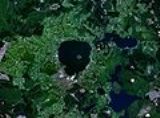
The Rotorua Caldera is one of several large volcano
es located in the Taupo Volcanic Zone
on the North Island
of New Zealand
. Its last major eruption was about 240,000 years ago. At this time, the Mamaku ignimbrite
, covering about 4000 square km, was deposited. After the eruption, the magma chamber
underneath the volcano collapsed. The circular depression left behind is the current caldera
, about 22 km (13.7 mi) in diameter and now occupied by Lake Rotorua
. Mokoia Island
, close to the centre of the lake, is a rhyolite
dome. There are other domes like Hinemoa Point, Ngongotaha, Pohaturoa and Pukeroa. The most recent magmatic eruption occurred less than 25,000 years ago, creating some of the smaller lava domes. There is also much geothermal activity.
Volcano
2. Bedrock3. Conduit 4. Base5. Sill6. Dike7. Layers of ash emitted by the volcano8. Flank| 9. Layers of lava emitted by the volcano10. Throat11. Parasitic cone12. Lava flow13. Vent14. Crater15...
es located in the Taupo Volcanic Zone
Taupo Volcanic Zone
The Taupo Volcanic Zone is a highly active volcanic V shaped area in the North Island of New Zealand that is spreading east -west at the rate of about 8mm per year...
on the North Island
North Island
The North Island is one of the two main islands of New Zealand, separated from the much less populous South Island by Cook Strait. The island is in area, making it the world's 14th-largest island...
of New Zealand
New Zealand
New Zealand is an island country in the south-western Pacific Ocean comprising two main landmasses and numerous smaller islands. The country is situated some east of Australia across the Tasman Sea, and roughly south of the Pacific island nations of New Caledonia, Fiji, and Tonga...
. Its last major eruption was about 240,000 years ago. At this time, the Mamaku ignimbrite
Ignimbrite
An ignimbrite is the deposit of a pyroclastic density current, or pyroclastic flow, a hot suspension of particles and gases that flows rapidly from a volcano, driven by a greater density than the surrounding atmosphere....
, covering about 4000 square km, was deposited. After the eruption, the magma chamber
Magma chamber
A magma chamber is a large underground pool of molten rock found beneath the surface of the Earth. The molten rock in such a chamber is under great pressure, and given enough time, that pressure can gradually fracture the rock around it creating outlets for the magma...
underneath the volcano collapsed. The circular depression left behind is the current caldera
Caldera
A caldera is a cauldron-like volcanic feature usually formed by the collapse of land following a volcanic eruption, such as the one at Yellowstone National Park in the US. They are sometimes confused with volcanic craters...
, about 22 km (13.7 mi) in diameter and now occupied by Lake Rotorua
Lake Rotorua
Lake Rotorua is the second largest lake in the North Island of New Zealand by surface area, and covers 79.8km2. With a mean depth of only 10 metres it is considerably smaller than nearby Lake Tarawera in terms of volume of water. It is located in the Bay of Plenty region...
. Mokoia Island
Mokoia Island
Mokoia Island is located in Lake Rotorua in New Zealand. It has an area of 1.35 square kilometres. The island is a rhyolite lava dome, rising to 180 metres above the lake surface. It erupted after the Rotorua caldera was formed, tapping a different magma source...
, close to the centre of the lake, is a rhyolite
Rhyolite
This page is about a volcanic rock. For the ghost town see Rhyolite, Nevada, and for the satellite system, see Rhyolite/Aquacade.Rhyolite is an igneous, volcanic rock, of felsic composition . It may have any texture from glassy to aphanitic to porphyritic...
dome. There are other domes like Hinemoa Point, Ngongotaha, Pohaturoa and Pukeroa. The most recent magmatic eruption occurred less than 25,000 years ago, creating some of the smaller lava domes. There is also much geothermal activity.