
Lake Rotorua
Encyclopedia
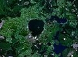
Lake Rotorua is the second largest lake
in the North Island
of New Zealand
by surface area, and covers 79.8km2. With a mean depth of only 10 metres it is considerably smaller than nearby Lake Tarawera
in terms of volume of water. It is located in the Bay of Plenty
region. The city of Rotorua
is sited on its southern shore, and the town of Ngongotaha
is at the western edge of the lake.
The lake was formed from the crater of a large volcano
in the Taupo Volcanic Zone
. Its last major eruption was about 240,000 years ago. After the eruption, the magma chamber
underneath the volcano collapsed. The circular depression left behind is the Rotorua Caldera
, which is the site of the lake. Several other lakes of volcanic origin are located nearby to the east, around the base of the active volcano Mount Tarawera
.
Lake Rotorua is fed with water from a number of rivers and streams; some such as the Utuhina flow water of a water temperature warmer than the lake due to the thermal activity in the Rotorua area. Conversely streams on the northern shore such as the Hamurana Spring
and the Awahou stream flow crystal clear water that has a constant temperature of 10 degrees Celsius. Other notable tributaries include the Ngongotaha
stream, famous for trout fishing.
Despite the large volume of water flowing through Lake Rotorua its shallow depth makes it very prone to discolouration, especially from sediment following windy weather. It is well used by fishermen, but less popular with watersports participants and swimmers.
 Lake Rotorua flows directly into Lake Rotoiti
via the Ohau Channel at the north eastern corner of the lake; this channel is navigable by boat and is also favoured by fly fishermen. The Ohau channel joins at the Mourea delta, an area with very low water levels. This area is frequented by novice kayakers and swimmers. Nearby is the ancestral land of the Ngati Pikiao hapu of the Te Arawa
tribe. From Lake Rotoiti the waters of Lake Rotorua flow to the Kaituna River
into the Pacific Ocean
near Maketu
; the rapid descent from over 900 feet above sea level in less than 20km has created an area used for extreme kayaking and white water rafting.
Mokoia Island
, close to the centre of the lake, is a rhyolite
dome. It is probably New Zealand's best-known lake island, and is closely associated with one of the best-known Māori
legends, that of Hinemoa and Tutanekai
. Is said that Hinemoa swam across the lake to her lover Tutanekai who lived on Mokoia Island.
Owing to the geothermal activity around the lake (including still active geyser
s and hot mud pools), the lake has a high sulphur
content. This gives the lake's waters an unusual yellowish-green hue.
Lake
A lake is a body of relatively still fresh or salt water of considerable size, localized in a basin, that is surrounded by land. Lakes are inland and not part of the ocean and therefore are distinct from lagoons, and are larger and deeper than ponds. Lakes can be contrasted with rivers or streams,...
in the North Island
North Island
The North Island is one of the two main islands of New Zealand, separated from the much less populous South Island by Cook Strait. The island is in area, making it the world's 14th-largest island...
of New Zealand
New Zealand
New Zealand is an island country in the south-western Pacific Ocean comprising two main landmasses and numerous smaller islands. The country is situated some east of Australia across the Tasman Sea, and roughly south of the Pacific island nations of New Caledonia, Fiji, and Tonga...
by surface area, and covers 79.8km2. With a mean depth of only 10 metres it is considerably smaller than nearby Lake Tarawera
Lake Tarawera
Lake Tarawera is the largest of a series of lakes which surround the volcano Mount Tarawera in the North Island of New Zealand. Like the mountain, it lies within the Okataina caldera. It is located 18 kilometres to the east of Rotorua, and five kilometres to the west of the mountain...
in terms of volume of water. It is located in the Bay of Plenty
Bay of Plenty
The Bay of Plenty , often abbreviated to BOP, is a region in the North Island of New Zealand situated around the body of water of the same name...
region. The city of Rotorua
Rotorua
Rotorua is a city on the southern shores of the lake of the same name, in the Bay of Plenty region of the North Island of New Zealand. The city is the seat of the Rotorua District, a territorial authority encompassing the city and several other nearby towns...
is sited on its southern shore, and the town of Ngongotaha
Ngongotaha
Ngongotaha is a town on the western shores of Lake Rotorua in New Zealand's North Island.It is located 10 kilometers northwest of Rotorua city, and is often regarded as an outer suburb of the larger centre. However, most locals would be adamant that Ngongotaha is an independent village in its own...
is at the western edge of the lake.
The lake was formed from the crater of a large volcano
Volcano
2. Bedrock3. Conduit 4. Base5. Sill6. Dike7. Layers of ash emitted by the volcano8. Flank| 9. Layers of lava emitted by the volcano10. Throat11. Parasitic cone12. Lava flow13. Vent14. Crater15...
in the Taupo Volcanic Zone
Taupo Volcanic Zone
The Taupo Volcanic Zone is a highly active volcanic V shaped area in the North Island of New Zealand that is spreading east -west at the rate of about 8mm per year...
. Its last major eruption was about 240,000 years ago. After the eruption, the magma chamber
Magma chamber
A magma chamber is a large underground pool of molten rock found beneath the surface of the Earth. The molten rock in such a chamber is under great pressure, and given enough time, that pressure can gradually fracture the rock around it creating outlets for the magma...
underneath the volcano collapsed. The circular depression left behind is the Rotorua Caldera
Rotorua Caldera
The Rotorua Caldera is one of several large volcanoes located in the Taupo Volcanic Zone on the North Island of New Zealand. Its last major eruption was about 240,000 years ago. At this time, the Mamaku ignimbrite, covering about 4000 square km, was deposited. After the eruption, the magma...
, which is the site of the lake. Several other lakes of volcanic origin are located nearby to the east, around the base of the active volcano Mount Tarawera
Mount Tarawera
Mount Tarawera is the volcano responsible for New Zealand's largest historic eruption. Located 24 kilometres southeast of Rotorua in the North Island, it consists of a series of rhyolitic lava domes that were fissured down the middle by an explosive basaltic eruption in 1886, which killed over...
.
Lake Rotorua is fed with water from a number of rivers and streams; some such as the Utuhina flow water of a water temperature warmer than the lake due to the thermal activity in the Rotorua area. Conversely streams on the northern shore such as the Hamurana Spring
Hamurana Spring
Hamurana Spring is the deepest natural fresh water spring on the North Island of New Zealand. Located to the north east of Lake Rotorua, the spring emerges from a rocky area within a Department of Conservation reserve. The spring is 920 feet above sea level and is approximately 15 metres deep...
and the Awahou stream flow crystal clear water that has a constant temperature of 10 degrees Celsius. Other notable tributaries include the Ngongotaha
Ngongotaha
Ngongotaha is a town on the western shores of Lake Rotorua in New Zealand's North Island.It is located 10 kilometers northwest of Rotorua city, and is often regarded as an outer suburb of the larger centre. However, most locals would be adamant that Ngongotaha is an independent village in its own...
stream, famous for trout fishing.
Despite the large volume of water flowing through Lake Rotorua its shallow depth makes it very prone to discolouration, especially from sediment following windy weather. It is well used by fishermen, but less popular with watersports participants and swimmers.
Lake Rotoiti, Bay of Plenty
Lake Rotoiti is a lake in the Bay of Plenty region of New Zealand. It is the northwesternmost in a chain of lakes formed within the Okataina caldera. The lake is close to the northern shore of its more famous neighbour, Lake Rotorua, and is connected to it via the Ohau Channel. It drains to the...
via the Ohau Channel at the north eastern corner of the lake; this channel is navigable by boat and is also favoured by fly fishermen. The Ohau channel joins at the Mourea delta, an area with very low water levels. This area is frequented by novice kayakers and swimmers. Nearby is the ancestral land of the Ngati Pikiao hapu of the Te Arawa
Te Arawa
Te Arawa is a confederation of Māori iwi and hapu based in the Rotorua and Bay of Plenty areas of New Zealand, with a population of around 40,000.The history of the Te Arawa people is inextricably linked to the Arawa canoe...
tribe. From Lake Rotoiti the waters of Lake Rotorua flow to the Kaituna River
Kaituna River
The Kaituna River is located in the Bay of Plenty region of the North Island of New Zealand. It is the outflow from Lakes Rotorua and Rotoiti, and flows northwards for 45 kilometres, emptying into the Bay of Plenty near Te Puke...
into the Pacific Ocean
Pacific Ocean
The Pacific Ocean is the largest of the Earth's oceanic divisions. It extends from the Arctic in the north to the Southern Ocean in the south, bounded by Asia and Australia in the west, and the Americas in the east.At 165.2 million square kilometres in area, this largest division of the World...
near Maketu
Maketu
Maketu is a small town on the Bay of Plenty Coast in New Zealand. It is located on Okurei point and has an estuary from which the Kaituna River used to flow out of, it is also adjacent to Newdicks Beach located on the south eastern side of Okurei point. The name is sometimes informally abbreviated...
; the rapid descent from over 900 feet above sea level in less than 20km has created an area used for extreme kayaking and white water rafting.
Mokoia Island
Mokoia Island
Mokoia Island is located in Lake Rotorua in New Zealand. It has an area of 1.35 square kilometres. The island is a rhyolite lava dome, rising to 180 metres above the lake surface. It erupted after the Rotorua caldera was formed, tapping a different magma source...
, close to the centre of the lake, is a rhyolite
Rhyolite
This page is about a volcanic rock. For the ghost town see Rhyolite, Nevada, and for the satellite system, see Rhyolite/Aquacade.Rhyolite is an igneous, volcanic rock, of felsic composition . It may have any texture from glassy to aphanitic to porphyritic...
dome. It is probably New Zealand's best-known lake island, and is closely associated with one of the best-known Māori
Maori mythology
Māori mythology and Māori traditions are the two major categories into which the legends of the Māori of New Zealand may usefully be divided...
legends, that of Hinemoa and Tutanekai
Mokoia Island
Mokoia Island is located in Lake Rotorua in New Zealand. It has an area of 1.35 square kilometres. The island is a rhyolite lava dome, rising to 180 metres above the lake surface. It erupted after the Rotorua caldera was formed, tapping a different magma source...
. Is said that Hinemoa swam across the lake to her lover Tutanekai who lived on Mokoia Island.
Owing to the geothermal activity around the lake (including still active geyser
Geyser
A geyser is a spring characterized by intermittent discharge of water ejected turbulently and accompanied by a vapour phase . The word geyser comes from Geysir, the name of an erupting spring at Haukadalur, Iceland; that name, in turn, comes from the Icelandic verb geysa, "to gush", the verb...
s and hot mud pools), the lake has a high sulphur
Sulfur
Sulfur or sulphur is the chemical element with atomic number 16. In the periodic table it is represented by the symbol S. It is an abundant, multivalent non-metal. Under normal conditions, sulfur atoms form cyclic octatomic molecules with chemical formula S8. Elemental sulfur is a bright yellow...
content. This gives the lake's waters an unusual yellowish-green hue.