

Ronne Antarctic Research Expedition
Encyclopedia
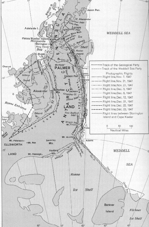
The Ronne Antarctic Research Expedition (RARE) was an expedition from 1947-1948 which researched the area surrounding the head of the Weddell Sea
in Antarctica.
led the RARE which was the final privately sponsored expedition from the United States
and explored and mapped the last unknown coastline on earth and determined that the Weddell Sea
and the Ross Sea
were not connected. The expedition included Isaac Schlossbach
, as second in command, who was to have Cape Schlossbach
named after him. The expedition, based out of Stonington Island
was the first to take women to over-winter. Ronne's wife, Edith Ronne
was correspondent for the North American Newspaper Alliance for expedition and the chief pilot Darlington took his wife.
Weddell Sea
The Weddell Sea is part of the Southern Ocean and contains the Weddell Gyre. Its land boundaries are defined by the bay formed from the coasts of Coats Land and the Antarctic Peninsula. The easternmost point is Cape Norvegia at Princess Martha Coast, Queen Maud Land. To the east of Cape Norvegia is...
in Antarctica.
Background
Finn RonneFinn Ronne
Finn Ronne was a U.S. Antarctic explorer.-Background:Finn Ronne was born in Horten, in Vestfold county, Norway. His father, Martin Rønne , was a polar explorer and served in Roald Amundsen's successful expedition to the South Pole...
led the RARE which was the final privately sponsored expedition from the United States
United States
The United States of America is a federal constitutional republic comprising fifty states and a federal district...
and explored and mapped the last unknown coastline on earth and determined that the Weddell Sea
Weddell Sea
The Weddell Sea is part of the Southern Ocean and contains the Weddell Gyre. Its land boundaries are defined by the bay formed from the coasts of Coats Land and the Antarctic Peninsula. The easternmost point is Cape Norvegia at Princess Martha Coast, Queen Maud Land. To the east of Cape Norvegia is...
and the Ross Sea
Ross Sea
The Ross Sea is a deep bay of the Southern Ocean in Antarctica between Victoria Land and Marie Byrd Land.-Description:The Ross Sea was discovered by James Ross in 1841. In the west of the Ross Sea is Ross Island with the Mt. Erebus volcano, in the east Roosevelt Island. The southern part is covered...
were not connected. The expedition included Isaac Schlossbach
Isaac Schlossbach
-Isaac "Ike" Schlossbach :Ike Schlossbach was a celebrated American polar explorer, submariner and aviation pioneer....
, as second in command, who was to have Cape Schlossbach
Cape Schlossbach
Cape Schlossbach is a headland forming the eastern end of the Prehn Peninsula, located between Hansen and Gardner inlets on the eastern side of the base of the Antarctic Peninsula. The cape was discovered by Finn Ronne in 1940 or/and 1947–48, who named it for Cdr. Isaac Schlossbach,...
named after him. The expedition, based out of Stonington Island
Stonington Island
Stonington Island is a rocky island lying 1 mile northeast of Neny Island in the eastern part of Marguerite Bay, off the west coast of Graham Land. Stonington Island is located at . Stonington Island, 0.4 miles long from northwest to southeast and 0.2 miles wide formerly connected by a drifted snow...
was the first to take women to over-winter. Ronne's wife, Edith Ronne
Edith Ronne
Edith "Jackie" Ronne was an American explorer of Antarctica and the first woman in the world to be a working member of an Antarctic expedition. She is also the namesake of the Ronne Ice Shelf.-Biography:...
was correspondent for the North American Newspaper Alliance for expedition and the chief pilot Darlington took his wife.
Partial Listing of Discoveries
- Mount AbramsMount AbramsMount Abrams is a mountain east of Mount Brice, in the Behrendt Mountains. Discovered and photographed from the air by the Ronne Antarctic Research Expedition 1947–48, under Finn Ronne. Named by Ronne for Talbert Abrams, a noted photogrammetric engineer and instrument manufacturer, who was a...
- Named for Talbert AbramsTalbert AbramsTalbert "Ted" Abrams was an American photographer and aviator known as the "father of aerial photography".-Early years:...
, noted photogrammetric engineer - Mount BeckerMount BeckerMount Becker is a prominent mountain northeast of Mount Boyer, in the Merrick Mountains. These mountains were discovered from the air and photographed by the Ronne Antarctic Research Expedition , 1947–48, under Finn Ronne. The mountain was named by Ronne for Ralph A. Becker, legal counsel who...
- Named for Ralph A. Becker, legal counsel who assisted in the formation of RARE - English CoastEnglish CoastEnglish Coast is that portion of the coast of Antarctica between the north tip of Rydberg Peninsula and Buttress Nunataks . To the west is Bryan Coast, and northward runs Rymill Coast east of Alexander Island across George VI Sound. This coast was discovered and explored in 1940, on land by Finn...
- Named for Capt. Robert A.J. English, USN, Executive Secretary of the USAS - Sweeney MountainsSweeney MountainsThe Sweeney Mountains is a group of mountains of moderate height and about extent, located north of the Hauberg Mountains in Palmer Land, Antarctica....
- Named for Mrs. Edward C. Sweeney, a contributor to the expedition - Behrendt MountainsBehrendt MountainsThe Behrendt Mountains is a group of mountains, 32 km long, aligned in the form of a horseshoe with the opening to the southwest, standing 11 km SW of Merrick Mountains at the base of the Antarctic Peninsula. Discovered and photographed from the air by the RARE, 1947-48, under Finn...
- Named for John C. Behrendt, traverse seismologist at Ellsworth Station - Merrick MountainsMerrick MountainsThe Merrick Mountains . are a cluster of mountains, 13 km long, standing 11 km northeast of the Behrendt Mountains in Palmer Land, Antarctica. Discovered and photographed from the air by the Ronne Antarctic Research Expedition, 1947–1948, under Finn Ronne.Named by US-ACAN for Conrad G...
- Named for Conrad G. Merrick, USGS topographic engineer - Gardner InletGardner InletGardner Inlet is a large, ice-filled inlet at the southwest side of Bowman Peninsula, on the east coast of Palmer Land. It was discovered by the Ronne Antarctic Research Expedition , 1947–48, under Ronne, who named it for Irvine C...
- Named for Irvine GardnerIrvine Clifton GardnerDr. Irvine Clifton Gardner was an American physicist.In 1921 he joined the National Bureau of Standards, and in 1950 became chief of the Division of Optics and Meteorology. He was the president of the Optical Society of America in 1958....
, physicist at the National Bureau of Standards - Thuronyi BluffThuronyi BluffThuronyi Bluff is a prominent escarpment on the east coast of the Antarctic Peninsula, which faces the Larsen Ice Shelf and the Weddell Sea and lies immediately south of the Antarctic Circle. It is located above Mill Inlet in British Antarctic Territory at the base of the Cole Peninsula, between...
- Named for Géza Thuronyi, an Antarctic scholar at the Library of CongressLibrary of CongressThe Library of Congress is the research library of the United States Congress, de facto national library of the United States, and the oldest federal cultural institution in the United States. Located in three buildings in Washington, D.C., it is the largest library in the world by shelf space and... - Wetmore GlacierWetmore GlacierWetmore Glacier is a glacier about 40 miles long, flowing southeast between the Rare Range and Latady Mountains into the north part of Gardner Inlet...
- Named for Alexander WetmoreAlexander WetmoreFrank Alexander Wetmore was an American ornithologist and avian paleontologist.-Life:Wetmore studied at the University of Kansas...
, Secretary of the Smithsonian InstitutionSmithsonian InstitutionThe Smithsonian Institution is an educational and research institute and associated museum complex, administered and funded by the government of the United States and by funds from its endowment, contributions, and profits from its retail operations, concessions, licensing activities, and magazines... - Irvine GlacierIrvine GlacierIrvine Glacier is a glacier, 40 miles long, draining southeast between the Guettard Range and the Rare Range into the north part of Gardner Inlet. It was discovered by the Ronne Antarctic Research Expedition , 1947–48, under Ronne, who named it for George J. Irvine, of the Engineer Depot at Fort...
- Named for George J. Irvine, of the Engineer Depot at Fort Belvoir, Virginia - Quilty NunataksQuilty NunataksQuilty Nunataks is a group of nunataks which extend over 8 miles , located 15 miles southwest of the Thomas Mountains in Palmer Land...
- Named for Patrick Quilty, geologist with the University of Wisconsin–MadisonUniversity of Wisconsin–MadisonThe University of Wisconsin–Madison is a public research university located in Madison, Wisconsin, United States. Founded in 1848, UW–Madison is the flagship campus of the University of Wisconsin System. It became a land-grant institution in 1866... - Mount ComanMount ComanMount Coman is a prominent isolated mountain which rises above the ice-covered plateau of Palmer Land, located just westward of the Playfair Mountains in Antarctica. It was discovered by the Ronne Antarctic Research Expedition, 1947–48, under Finn Ronne, who named this mountain for Dr. F. Dana...
- Named for Dr. F. Dana Coman, physician with the Byrd Antarctic Expedition - Haag NunataksHaag NunataksHaag Nunataks are a group of three low elevations aligned nearly north-south. The dominant central nunatak and the southern elevation have definite rock exposures; the minor northern elevation may be entirely snow covered...
- Named for Joseph Haag, head of Todd Pacific ShipyardsTodd Pacific ShipyardsVigor Shipyards was founded in 1916 as the William H. Todd Corporation through the merger of Robins Dry Dock & Repair Company of Erie Basin, Brooklyn, New York, the Tietjen & Long Dry Dock Company of Hoboken, New Jersey, and the Seattle Construction and Dry Dock Company... - Ewing IslandEwing IslandEwing Island is an ice-covered, dome-shaped island 8 miles in diameter, lying 15 miles northeast of Cape Collier, off the east coast of Palmer Land. It was discovered from the air on November 7, 1947 by the Ronne Antarctic Research Expedition , under Ronne, who named it for Dr. Maurice Ewing of...
- Named for Dr. Maurice Ewing, Columbia UniversityColumbia UniversityColumbia University in the City of New York is a private, Ivy League university in Manhattan, New York City. Columbia is the oldest institution of higher learning in the state of New York, the fifth oldest in the United States, and one of the country's nine Colonial Colleges founded before the...
, assisted in planning RARE - Cape AdamsCape AdamsCape Adams is an abrupt rock scarp marking the south tip of Bowman Peninsula and forming the north side of the entrance to Gardner Inlet, on the east coast of Palmer Land in Antarctica. It was discovered by the Ronne Antarctic Research Expedition , 1947–48, under Ronne, and named by him for Lt....
- Named for Lt. Charles J. Adams of the then USAAF, pilot with the expedition - Bowman PeninsulaBowman PeninsulaBowman Peninsula is a peninsula, long in a north-south direction and wide in its northern and central portions, lying between Nantucket Inlet and Gardner Inlet on the east coast of Palmer Land. The peninsula is ice covered and narrows toward the south, terminating in Cape Adams...
- Named for Isaiah BowmanIsaiah BowmanIsaiah Bowman, AB, Ph. D. was an American geographer...
, American geographer. - Orville CoastOrville CoastOrville Coast is that portion of the coast of Antarctica lying west of Ronne Ice Shelf between Cape Adams and Cape Zumberge. It was discovered by the Ronne Antarctic Research Expedition , 1947-48, under Ronne, who named this coast for Capt. Howard T. Orville, USN, Head of the Naval Aerological...
- Named for Capt. Howard T. Orville, USN, Head of the Naval Aerological Service - Ketchum GlacierKetchum GlacierKetchum Glacier is an eastward flowing glacier at the base of Palmer Land, about 50 miles long, descending between the Latady Mountains and the Scaife Mountains into Gardner Inlet. It was discovered by the Ronne Antarctic Research Expedition , 1947–48, under Ronne, who named it for Cdr...
- Named for Cdr. Gerald Ketchum, USN, commander of the Burton Island - Mount Austin (Antarctica)Mount Austin (Antarctica)Mount Austin is a conspicuous rock mass rising to 955 metres, projecting into the head of Gardner Inlet, on the east coast of Palmer Land. Discovered by the Ronne Antarctic Research Expedition , 1947-48, under Ronne, and named by him for Stephen F. Austin, American colonizer in Texas and one of...
- Named for Stephen F. AustinStephen F. AustinStephen Fuller Austin was born in Virginia and raised in southeastern Missouri. He was known as the Father of Texas, led the second, but first legal and ultimately successful colonization of the region by bringing 300 families from the United States. The capital of Texas, Austin in Travis County,...
, American colonizer in TexasTexasTexas is the second largest U.S. state by both area and population, and the largest state by area in the contiguous United States.The name, based on the Caddo word "Tejas" meaning "friends" or "allies", was applied by the Spanish to the Caddo themselves and to the region of their settlement in... - Mount Edward - Named for Cdr. Edward C. Sweeney, USNR, a contributor to the expedition
- Mount Owen (Antarctica)Mount Owen (Antarctica)Mount Owen is a mountain on the eastern coast of Palmer Land on the Antarctic Peninsula. It stands 1,105 m in height, and was named by Ronne for Arthur Owen, a member of the Ronne Antarctic Research Expedition....
- Named for Arthur Owen, a member of the Ronne Antarctic Research ExpeditionRonne Antarctic Research ExpeditionThe Ronne Antarctic Research Expedition was an expedition from 1947-1948 which researched the area surrounding the head of the Weddell Sea in Antarctica.-Background:...