
Romanoro
Encyclopedia
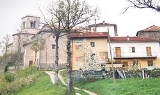
Romonoro is a small hamlet (about 245 inhabitants in Winter, 740 inhabitants during Summer holiday, in the entire frazione
) in the province of Modena
in central Italy
, administratively a frazione
of Frassinoro
. It is about 700 metres (2,296.6 ft) above sea level
.
Romanoro houses a dairy facility which produces Parmigiano-Reggiano cheese. Right below the town flows the Dolo
mountain stream. A dam exists at the top of Fontanaluccia
, that deviates part of the water about 16 km (9.9 mi) downward to the hydroelectric power plant located in the nearby Farneta
.
 First official documents mentioning the village date back to 1204 as Armanorium. In fact the "Armanorium" term can be traced back up to the presence of Arimanni (800 AD), Lombard
soldiers to whom where given estates and lots in strategic territory with both agricultural and defensive purpose.
Once the Lombard Kingdom of northern Italy was conquered by Charlemagne
, the whole Dolo valley was given in administration to medieval Rubbiano settlement; it remained to the latter until 1071, when local ruler Beatrice of Lorena, mother of Matilda of Tuscany
, gave the Dolo valley in administration to the Frassinoro
Hospice, thus creating by then the Frassinoro Benedictine Abbey
.
At the beginning of the 14th century, together with Morsiano
and Fontanaluccia
, it was part of the Muschioso stronghold, administrated by the Lords of Dallo. According to the 1315 census, Cerreto, Panigale and Montale
villages were part of the Romanoro comune. The Dallo were followed by the Montecuccoli family, that hold the Badia land until 1426, when they were replaced by the Estensi of Montefiorino
(a branch of whom was Duke of Modena and Reggio). At the beginning of the 16th century the mountains were ravaged in the course of the war between the House of Este and the Papal States
.
(44°19′22"N 10°32′11"E) has been opened the 14th of November 2009
Construction of a bridge over this landslide had been planned to start in 2006, and it has been finished in November 2009.
Frazione
A frazione , in Italy, is the name given in administrative law to a type of territorial subdivision of a comune; for other administrative divisions, see municipio, circoscrizione, quartiere...
) in the province of Modena
Province of Modena
The Province of Modena is a province in the Emilia-Romagna region of Italy. Its capital is the city of Modena.It has an area of 2,689 km², and a total population of 659,925 . There are 48 comuni in the province, see Comuni of the Province of Modena.At May 31, 2005, the main comuni by population...
in central Italy
Italy
Italy , officially the Italian Republic languages]] under the European Charter for Regional or Minority Languages. In each of these, Italy's official name is as follows:;;;;;;;;), is a unitary parliamentary republic in South-Central Europe. To the north it borders France, Switzerland, Austria and...
, administratively a frazione
Frazione
A frazione , in Italy, is the name given in administrative law to a type of territorial subdivision of a comune; for other administrative divisions, see municipio, circoscrizione, quartiere...
of Frassinoro
Frassinoro
Frassinoro is a comune in the Province of Modena in the Italian region Emilia-Romagna, located about 70 km southwest of Bologna and about 50 km southwest of Modena....
. It is about 700 metres (2,296.6 ft) above sea level
Above mean sea level
The term above mean sea level refers to the elevation or altitude of any object, relative to the average sea level datum. AMSL is used extensively in radio by engineers to determine the coverage area a station will be able to reach...
.
Romanoro houses a dairy facility which produces Parmigiano-Reggiano cheese. Right below the town flows the Dolo
Dolo River
The Dolo mountain stream springs from the Mount Cusna's slopes , in the Reggio-Emilia province, in the Tuscany-Emilia Romagna Apennine Mountains.It is a natural boundary for the province of Reggio Emilia and the province of Modena....
mountain stream. A dam exists at the top of Fontanaluccia
Fontanaluccia
Fontanaluccia is a frazione of the comune of Frassinoro, Emilia-Romagna, central Italy. It is located at an altitude of 853 m.Nearby is the dam on the river Dolo, which provides water for the hydroelectric power plant of Farneta....
, that deviates part of the water about 16 km (9.9 mi) downward to the hydroelectric power plant located in the nearby Farneta
Farneta
Farneta is a town and frazione of the comune of Montefiorino, Italy, located in the Apennines of the province of Modena.Located between the two hamlets of Gusciola and Romanoro Farneta is a town and frazione of the comune of Montefiorino, Italy, located in the Apennines of the province of...
.
History
Lombards
The Lombards , also referred to as Longobards, were a Germanic tribe of Scandinavian origin, who from 568 to 774 ruled a Kingdom in Italy...
soldiers to whom where given estates and lots in strategic territory with both agricultural and defensive purpose.
Once the Lombard Kingdom of northern Italy was conquered by Charlemagne
Charlemagne
Charlemagne was King of the Franks from 768 and Emperor of the Romans from 800 to his death in 814. He expanded the Frankish kingdom into an empire that incorporated much of Western and Central Europe. During his reign, he conquered Italy and was crowned by Pope Leo III on 25 December 800...
, the whole Dolo valley was given in administration to medieval Rubbiano settlement; it remained to the latter until 1071, when local ruler Beatrice of Lorena, mother of Matilda of Tuscany
Matilda of Tuscany
Matilda of Tuscany was an Italian noblewoman, the principal Italian supporter of Pope Gregory VII during the Investiture Controversy. She is one of the few medieval women to be remembered for her military accomplishments...
, gave the Dolo valley in administration to the Frassinoro
Frassinoro
Frassinoro is a comune in the Province of Modena in the Italian region Emilia-Romagna, located about 70 km southwest of Bologna and about 50 km southwest of Modena....
Hospice, thus creating by then the Frassinoro Benedictine Abbey
Abbey of Frassinoro
The Abbey of Frassinoro was one of the many Benedictine monasteries throughout Europe associated with the noblewoman Matilda of Tuscany, who reigned over the Badia lands near Frassinoro...
.
At the beginning of the 14th century, together with Morsiano
Morsiano
Morsiano is a hamlet administratively a frazione of Villa Minozzo in the province of Reggio Emilia. Located in the tuscany-emilia apennines near the Mount Cusna slopes. It is about 720 meters above sea level....
and Fontanaluccia
Fontanaluccia
Fontanaluccia is a frazione of the comune of Frassinoro, Emilia-Romagna, central Italy. It is located at an altitude of 853 m.Nearby is the dam on the river Dolo, which provides water for the hydroelectric power plant of Farneta....
, it was part of the Muschioso stronghold, administrated by the Lords of Dallo. According to the 1315 census, Cerreto, Panigale and Montale
villages were part of the Romanoro comune. The Dallo were followed by the Montecuccoli family, that hold the Badia land until 1426, when they were replaced by the Estensi of Montefiorino
Montefiorino
Montefiorino is a comune in the Province of Modena in the Italian region Emilia-Romagna, located about 60 km southwest of Bologna and about 40 km southwest of Modena....
(a branch of whom was Duke of Modena and Reggio). At the beginning of the 16th century the mountains were ravaged in the course of the war between the House of Este and the Papal States
Papal States
The Papal State, State of the Church, or Pontifical States were among the major historical states of Italy from roughly the 6th century until the Italian peninsula was unified in 1861 by the Kingdom of Piedmont-Sardinia .The Papal States comprised territories under...
.
Roads
A bridge over the Valoria landslideLandslide
A landslide or landslip is a geological phenomenon which includes a wide range of ground movement, such as rockfalls, deep failure of slopes and shallow debris flows, which can occur in offshore, coastal and onshore environments...
(44°19′22"N 10°32′11"E) has been opened the 14th of November 2009
Construction of a bridge over this landslide had been planned to start in 2006, and it has been finished in November 2009.