

Rock and Pillar Range
Encyclopedia
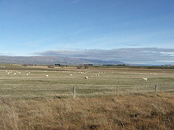
Maniototo
The Maniototo Plain, usually simply known as The Maniototo, is an elevated inland region in Otago, New Zealand. The region roughly surrounds the upper reaches of the Taieri River and the Manuherikia River. It is bounded by the Kakanui Range to the north and the Rock and Pillar Range to the southeast...
, an area of inland Otago
Otago
Otago is a region of New Zealand in the south of the South Island. The region covers an area of approximately making it the country's second largest region. The population of Otago is...
, New Zealand
New Zealand
New Zealand is an island country in the south-western Pacific Ocean comprising two main landmasses and numerous smaller islands. The country is situated some east of Australia across the Tasman Sea, and roughly south of the Pacific island nations of New Caledonia, Fiji, and Tonga...
. They are surrounded by the Taieri River
Taieri River
The Taieri River is the fourth-longest river in New Zealand and is located in Otago in the South Island. Rising in the Lammerlaw ranges, it initially flows north, then east around the Rock and Pillar range before turning southeast, reaching the sea 30 km south of Dunedin.The upper reaches meander...
, which has its source in the range, flowing out across the scroll plain
Scroll plain
A scroll plain occurs where a river meanders across an area with a very low gradient, usually with a fairly continuous discharge. In addition to meanders, scroll plains are also characterised by many oxbow lakes.-New Zealand:...
at Paerau
Paerau
Paerau is a small settlement in inland Otago in New Zealand's South Island. It is located in the upper valley of the Taieri River), at the foot of the Rock and Pillar Range...
, before almost doubling back on itself at Waipiata
Waipiata
Waipiata is an historic place on the Otago Central Rail Trail, in Central Otago, New Zealand.* Waipiata is also the name of many New Zealand coastal vessels, steamers, freighters and steamships. -History:...
and flowing back along the other side through the Strath-Taieri. The town of Middlemarch
Middlemarch, New Zealand
Middlemarch is a small town within the limits of Dunedin city in New Zealand with 300 inhabitants. It lies some 80km to the west of the city centre, at the foot of the Rock and Pillar Range of hills in the broad Strath-Taieri valley, through which flows the middle reaches of the Taieri...
lies close to the Taieri to the east of the range, and Patearoa
Patearoa
Patearoa is a small settlement in inland Otago in New Zealand's South Island. It is located 20 kilometres southwest of Ranfurly, in the Maniototo and was originally known as Sowburn....
lies to the northwest.
The Rock and Pillars are a horst range, caused by movement on two parallel faults uplifting the area in between. Thus, the range is characterised by a very flat top, with steep escarpment
Escarpment
An escarpment is a steep slope or long cliff that occurs from erosion or faulting and separates two relatively level areas of differing elevations.-Description and variants:...
s on either side. The Great Moss Swamp
Great Moss Swamp
The Great Moss Swamp is located in Otago, New Zealand, at 45°33'S, 169°56'E. It lies in the Maniototo, close to the former gold mining route of the Old Dunstan Road, 85 kilometres to the northwest of Dunedin city centre....
lies on the upper surface of the range. There is a persistent and highly unusual cloud formation associated with the range. This strange cloud formation, found only in one or two places in the world, is more or less stationary and is called the Taieri Pet by the local inhabitants. It is formed by high north-westerly winds being forced upward over the Rock & Pillar range. Big Hut, situated near the summit of the range, is available for public use.
The range takes its name from the rock formations that cover parts of it. The highest point in the range is Summit Rock, at 1450 metres (4756 feet), and several lower points include Stonehenge (1380 m) and McPhee's Rock (1013 m).