

Roanoke, VA MSA
Encyclopedia
Virginia
The Commonwealth of Virginia , is a U.S. state on the Atlantic Coast of the Southern United States. Virginia is nicknamed the "Old Dominion" and sometimes the "Mother of Presidents" after the eight U.S. presidents born there...
as defined by the United States
United States
The United States of America is a federal constitutional republic comprising fifty states and a federal district...
Office of Management and Budget (OMB). The Roanoke MSA is sometimes referred to as the Roanoke Valley
Roanoke Valley
The Roanoke Valley in southwest Virginia is an area adjacent to and including the Roanoke River between the Blue Ridge Mountains to the east and the Appalachian Plateau to the west...
, even though the Roanoke MSA occupies a larger area than the Roanoke Valley. It is geographically similar to the area known as the Roanoke Region of Virginia
Roanoke Region of Virginia
The Roanoke Region is the area of the Commonwealth of Virginia surrounding the city of Roanoke. Its usage may refer to the metropolitan statistical area or the Roanoke Valley, but it sometimes includes areas in the Allegheny Mountains and New River Valley which includes Alleghany county, Montgomery...
, but while the latter includes Alleghany County, the former does not. As of the 2000 census
United States Census, 2000
The Twenty-second United States Census, known as Census 2000 and conducted by the Census Bureau, determined the resident population of the United States on April 1, 2000, to be 281,421,906, an increase of 13.2% over the 248,709,873 persons enumerated during the 1990 Census...
, the MSA had a population of 288,309 (though a July 1, 2009 estimate placed the population at 300,399).
Figures through 2000 do not include Franklin County (50,345 est. 2005 population) and Craig County (5,154 est. 2005 population). The Census Bureau has since added them to the Roanoke MSA, which is the fourth largest in Virginia (behind Northern Virginia
Northern Virginia
Northern Virginia consists of several counties and independent cities in the Commonwealth of Virginia, in a widespread region generally radiating southerly and westward from Washington, D.C...
, Hampton Roads
Hampton Roads
Hampton Roads is the name for both a body of water and the Norfolk–Virginia Beach metropolitan area which surrounds it in southeastern Virginia, United States...
, and the Greater Richmond
Richmond-Petersburg
The Greater Richmond Region is a region located in a central part of the state of Virginia in the United States. As of 2010, it had a population of 1,258,251, making it the 43rd largest MSA in the country...
area), and the largest in the western half of the state. Its current rank is 201 among all 363 MSAs. The Roanoke, VA MSA population changed from 288,471 in 2000 to 298,694 in 2008, a 3.54 percent change. The population is projected to be 324,882 in 2020, a 12.62 percent change between 2000 and 2020.
MSA components
Note: Since a state constitutional change in 1871, all cities in VirginiaVirginia
The Commonwealth of Virginia , is a U.S. state on the Atlantic Coast of the Southern United States. Virginia is nicknamed the "Old Dominion" and sometimes the "Mother of Presidents" after the eight U.S. presidents born there...
are independent cities
Independent city
An independent city is a city that does not form part of another general-purpose local government entity. These type of cities should not be confused with city-states , which are fully sovereign cities that are not part of any other sovereign state.-Historical precursors:In the Holy Roman Empire,...
that are not located in any county. The OMB considers these independent cities to be county-equivalents for the purpose of defining MSAs in Virginia.
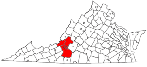
Four counties and two independent cities are included in the Roanoke Metropolitan Statistical Area.
- Counties
- BotetourtBotetourt County, VirginiaAs of the census of 2000, there were 30,496 people, 11,700 households, and 9,114 families residing in the county. The population density was 56 people per square mile . There were 12,571 housing units at an average density of 23 per square mile...
- CraigCraig County, VirginiaAs of the census of 2000, there were 5,091 people, 2,060 households, and 1,507 families residing in the county. The population density was 15 people per square mile . There were 2,554 housing units at an average density of 8 per square mile...
- FranklinFranklin County, VirginiaAs of the census of 2000, there were 47,286 people, 18,963 households, and 13,918 families residing in the county. The population density was 68 people per square mile . There were 22,717 housing units at an average density of 33 per square mile...
- RoanokeRoanoke County, VirginiaRoanoke County is a county located in the U.S. state of the Commonwealth of Virginia. It is part of the Roanoke Metropolitan Statistical Area and located within the Roanoke Region of Virginia. As of the 2000 census, the population was 85,778. As of 2010, the population was 92,376...
- Botetourt
- Independent Cities
- RoanokeRoanoke, VirginiaRoanoke is an independent city in the Mid-Atlantic U.S. state of Virginia and is the tenth-largest city in the Commonwealth. It is located in the Roanoke Valley of the Roanoke Region of Virginia. The population within the city limits was 97,032 as of 2010...
- SalemSalem, VirginiaSalem is an independent city in Virginia, USA, bordered by the city of Roanoke to the east but otherwise adjacent to Roanoke County. It is part of the Roanoke Metropolitan Statistical Area. The population was 24,802 according to 2010 U.S. Census...
- Roanoke
Politics
| Year | GOP Republican Party (United States) The Republican Party is one of the two major contemporary political parties in the United States, along with the Democratic Party. Founded by anti-slavery expansion activists in 1854, it is often called the GOP . The party's platform generally reflects American conservatism in the U.S... |
DEM Democratic Party (United States) The Democratic Party is one of two major contemporary political parties in the United States, along with the Republican Party. The party's socially liberal and progressive platform is largely considered center-left in the U.S. political spectrum. The party has the lengthiest record of continuous... |
Others |
|---|---|---|---|
| 2008 United States presidential election, 2008 The United States presidential election of 2008 was the 56th quadrennial presidential election. It was held on November 4, 2008. Democrat Barack Obama, then the junior United States Senator from Illinois, defeated Republican John McCain, the senior U.S. Senator from Arizona. Obama received 365... |
54.6% 81,633 | 44.2% 66,098 | 1.2% 1,805 |
| 2004 United States presidential election, 2004 The United States presidential election of 2004 was the United States' 55th quadrennial presidential election. It was held on Tuesday, November 2, 2004. Republican Party candidate and incumbent President George W. Bush defeated Democratic Party candidate John Kerry, the then-junior U.S. Senator... |
60.0% 80,991 | 39.2% 52,901 | 0.9% 1,205 |
| 2000 United States presidential election, 2000 The United States presidential election of 2000 was a contest between Republican candidate George W. Bush, then-governor of Texas and son of former president George H. W. Bush , and Democratic candidate Al Gore, then-Vice President.... |
55.8% 68,230 | 41.8% 51,032 | 2.4% 2,929 |
| 1996 United States presidential election, 1996 The United States presidential election of 1996 was a contest between the Democratic national ticket of President Bill Clinton of Arkansas and Vice President Al Gore of Tennessee and the Republican national ticket of former Senator Bob Dole of Kansas for President and former Housing Secretary Jack... |
53.1% 52,684 | 36.2% 35,922 | 10.7% 10,636 |
| 1992 United States presidential election, 1992 The United States presidential election of 1992 had three major candidates: Incumbent Republican President George Bush; Democratic Arkansas Governor Bill Clinton, and independent Texas businessman Ross Perot.... |
45.1% 52,889 | 31.3% 43,360 | 13.6% 15,888 |
| 1988 United States presidential election, 1988 The United States presidential election of 1988 featured no incumbent president, as President Ronald Reagan was unable to seek re-election after serving the maximum two terms allowed by the Twenty-second Amendment. Reagan's Vice President, George H. W. Bush, won the Republican nomination, while the... |
56.0% 57,284 | 43.2% 44,244 | 0.8% 826 |
| 1984 United States presidential election, 1984 The United States presidential election of 1984 was a contest between the incumbent President Ronald Reagan, the Republican candidate, and former Vice President Walter Mondale, the Democratic candidate. Reagan was helped by a strong economic recovery from the deep recession of 1981–1982... |
60.9% 63,591 | 38.5% 40,207 | 0.6% 642 |
| 1980 United States presidential election, 1980 The United States presidential election of 1980 featured a contest between incumbent Democrat Jimmy Carter and his Republican opponent, Ronald Reagan, as well as Republican Congressman John B. Anderson, who ran as an independent... |
49.1% 47,377 | 46.1% 44,405 | 4.7% 4,570 |
| 1976 United States presidential election, 1976 The United States presidential election of 1976 followed the resignation of President Richard Nixon in the wake of the Watergate scandal. It pitted incumbent President Gerald Ford, the Republican candidate, against the relatively unknown former governor of Georgia, Jimmy Carter, the Democratic... |
43.9% 39,942 | 54.7% 49,783 | 1.4% 1,301 |
| 1972 United States presidential election, 1972 The United States presidential election of 1972 was the 47th quadrennial United States presidential election. It was held on November 7, 1972. The Democratic Party's nomination was eventually won by Senator George McGovern, who ran an anti-war campaign against incumbent Republican President Richard... |
70.4% 53,364 | 27.4% 20,777 | 2.2% 1,672 |
| 1968 United States presidential election, 1968 The United States presidential election of 1968 was the 46th quadrennial United States presidential election. Coming four years after Democrat Lyndon B. Johnson won in a historic landslide, it saw Johnson forced out of the race and Republican Richard Nixon elected... |
52.2% 37,977 | 25.1% 18,268 | 22.6% 16,439 |
| 1964 United States presidential election, 1964 The United States presidential election of 1964 was held on November 3, 1964. Incumbent President Lyndon B. Johnson had come to office less than a year earlier following the assassination of his predecessor, John F. Kennedy. Johnson, who had successfully associated himself with Kennedy's... |
48.3% 28,732 | 63.0% 30,713 | 0.1% 44 |
| 1960 United States presidential election, 1960 The United States presidential election of 1960 was the 44th American presidential election, held on November 8, 1960, for the term beginning January 20, 1961, and ending January 20, 1965. The incumbent president, Republican Dwight D. Eisenhower, was not eligible to run again. The Republican Party... |
60.7% 29,010 | 39.0% 18,638 | 0.3% 122 |
Places with 10,000 to 30,000 inhabitants
- Cave SpringCave Spring, VirginiaCave Spring is a census-designated place in Roanoke County, Virginia, United States. The population was 24,922 at the 2010 census. Cave Spring covers much of the area known locally as "Southwest County" which has the most affluent suburbs of Roanoke...
(census-designated placeCensus-designated placeA census-designated place is a concentration of population identified by the United States Census Bureau for statistical purposes. CDPs are delineated for each decennial census as the statistical counterparts of incorporated places such as cities, towns and villages...
) - HollinsHollins, VirginiaHollins is a census-designated place in Botetourt and Roanoke counties in the U.S. state of Virginia. Hollins covers much of the area known locally as "North County". The population was 14,309 at the 2000 census. It is part of the Roanoke Metropolitan Statistical Area...
(census-designated place) - SalemSalem, VirginiaSalem is an independent city in Virginia, USA, bordered by the city of Roanoke to the east but otherwise adjacent to Roanoke County. It is part of the Roanoke Metropolitan Statistical Area. The population was 24,802 according to 2010 U.S. Census...
Places with 1,000 to 10,000 inhabitants
- Blue RidgeBlue Ridge, VirginiaBlue Ridge is a census-designated place in Botetourt County, Virginia, United States. The population was 3,188 at the 2000 census. It is part of the Roanoke Metropolitan Statistical Area.-Geography:...
(census-designated place) - BuchananBuchanan, VirginiaBuchanan is a town in Botetourt County, Virginia, United States. The population was 1,233 at the 2000 census. It is part of the Roanoke Metropolitan Statistical Area.-Geography:Buchanan is located at ....
- CloverdaleCloverdale, VirginiaCloverdale is a census-designated place in Botetourt County, Virginia, United States. The population was 2,986 at the 2000 census. It is part of the Roanoke Metropolitan Statistical Area....
(census-designated place) - DalevilleDaleville, VirginiaDaleville is a census-designated place in Botetourt County, Virginia, United States. The population was 1,454 as of the 2000 census. It is part of the Roanoke Metropolitan Statistical Area...
(census-designated place) - FerrumFerrum, VirginiaFerrum is a census-designated place in Franklin County, Virginia, United States. The population was 1,313 at the 2000 census. Ferrum is home to Ferrum College and its Blue Ridge Folklife Festival...
(census-designated place) - LaymantownLaymantown, VirginiaLaymantown is a census-designated place in Botetourt County, Virginia, United States. The population was 2,034 at the 2000 census. It is part of the Roanoke Metropolitan Statistical Area.-Geography:Laymantown is located at ....
(census-designated place) - North ShoreNorth Shore, VirginiaNorth Shore is a census-designated place in Franklin County, Virginia, United States. The population was 2,112 at the 2000 census. It is part of the Roanoke Metropolitan Statistical Area.-Geography:North Shore is located at ....
(census-designated place) - Rocky MountRocky Mount, VirginiaRocky Mount is the county seat of Franklin County, Virginia, United States. The town is part of the Roanoke Metropolitan Statistical Area, and had a population of 4,066 at the 2000 census. It is located in the Roanoke Region of Virginia-History:...
- VintonVinton, VirginiaVinton is a town in Roanoke County, Virginia, United States. The population was 7,782 at the 2000 census. It hosted teams by three names in the ECHL in a custom built facility known as the LancerLot; after the roof collapsed during the Blizzard of 1993, the franchise moved to the Roanoke Civic...
Places with less than 1,000 inhabitants
- Boones MillBoones Mill, VirginiaBoones Mill is a town in Franklin County, Virginia, United States. The population was 285 at the 2000 census. It is part of the Roanoke Metropolitan Statistical Area.-Geography:Boones Mill is located at ....
- FincastleFincastle, VirginiaFincastle is a town in Botetourt County, Virginia, United States. The population was 353 at the 2010 census. It is the county seat of Botetourt County.Fincastle is part of the Roanoke Metropolitan Statistical Area.-History:...
- New CastleNew Castle, VirginiaNew Castle is the only town in Craig County, Virginia, United States. The population was 153 at the 2010 census...
- PenhookPenhook, VirginiaPenhook is a census-designated place in Franklin County, Virginia, United States. The population was 726 at the 2000 census. It is part of the Roanoke Metropolitan Statistical Area.-Geography:Penhook is located at ....
(census-designated place) - TroutvilleTroutville, VirginiaTroutville is a town in Botetourt County, Virginia, United States. The population was 432 at the 2000 census. It is part of the Roanoke Metropolitan Statistical Area.-History:...
- Union HallUnion Hall, VirginiaUnion Hall is a census-designated place in Franklin County, Virginia, United States. The population was 957 at the 2000 census. It is part of the Roanoke Metropolitan Statistical Area.-Geography:Union Hall is located at ....
(census-designated place) - Westlake CornerWestlake Corner, VirginiaWestlake Corner is a census-designated place in Franklin County, Virginia, United States. The population was 899 at the 2000 census. It is part of the Roanoke Metropolitan Statistical Area.-Geography:Westlake Corner is located at ....
(census-designated place)
Unincorporated places
|
Dillon, Virginia Dillon is an unincorporated community in Botetourt County, Virginia, United States.... Dundee, Virginia Dundee is an unincorporated community in Pittsylvania County, in the U.S. state of Virginia.... Eagle Rock, Virginia Eagle Rock is an unincorporated community in Botetourt County, Virginia, United States, located on the James River between Iron Gate and Buchanan, Virginia.-Geography:Eagle Rock is located at . Its elevation is .-History:... Flatwoods, Virginia Flatwoods is an unincorporated community in Botetourt County, Virginia, United States.... Fork Mountain, Virginia Fork Mountain is an unincorporated community in Botetourt County, Virginia, United States.... Gala, Virginia Gala is an unincorporated community in Botetourt County, Virginia, United States.... Glebe Mills, Virginia Glebe Mills is an unincorporated community in Botetourt County, Virginia, United States.... Glen Wilton, Virginia Glen Wilton is an unincorporated community in Botetourt County, Virginia, United States.... Glenvar, Virginia Glenvar is a census-designated place in western Roanoke County, Virginia, United States. The population as of the 2010 Census was 976. The center of the community lies along U.S. 11/U.S. 460 about one mile west of the Salem city limits. The community is home to Glenvar High School which serves... Greyledge, Virginia Greyledge is an unincorporated community in Botetourt County, Virginia, United States.... Haden, Virginia Haden is an unincorporated community in Botetourt County, Virginia, United States.... Hale's Ford, Virginia Hale's Ford is a small unincorporated community located in the northeastern corner of Franklin County, Virginia about from Roanoke. It is most notable as the location of the Burroughs Farm, the tobacco plantation where the famed... Hanging Rock, Virginia Hanging Rock is an unincorporated community in Roanoke County, Virginia, United States located directly north of Salem. The community is named for a prominent rock outcrop. The intersection of Virginia State Route 311 and Virginia State Route 419 is in Hanging Rock... Harvey, Virginia Harvey is an unincorporated community in Botetourt County, Virginia, United States.... Haymakertown, Virginia Haymakertown is an unincorporated community in Botetourt County, Virginia, United States.... Heatherstone, Virginia Heatherstone is an unincorporated community in Botetourt County, Virginia, United States.... Hipes, Virginia Hipes is an unincorporated community in Botetourt County, Virginia, United States that lies along Virginia State Route 615.... Howell Mills, Virginia Howell Mills is an unincorporated community in Botetourt County, Virginia, United States.... |
Kyles Mills, Virginia Kyles Mills is an unincorporated community in Botetourt County, Virginia, United States.... Lignite, Virginia Lignite is a ghost town in Botetourt County, Virginia, United States. A former lignite coal mining town, it consisted of a company store, churches, and a main street theater. It was abandoned in 1890 after ore demands dropped... Lithia, Virginia Lithia is an unincorporated community in Botetourt County, Virginia, United States.... Lone Star, Virginia Lone Star is an unincorporated community in Botetourt County, Virginia, United States.... Maggie, Virginia Maggie is an unincorporated community in west, central Craig County, Virginia, United States. It lies along State Route 632.... Marshalltown, Virginia Marshalltown is an unincorporated community in east, central Craig County, Virginia, United States. It lies along State Route 615, northeast of New Castle.... Mount Union, Virginia Mount Union is an unincorporated community in Botetourt County, Virginia, United States.... Munford, Virginia Munford is an unincorporated community in Botetourt County, Virginia, United States.... Nace, Virginia Nace is an unincorporated community in Botetourt County, Virginia, United States.... Oldfields, Virginia Oldfields is an unincorporated community in Botetourt County, Virginia, United States.... Oriskany, Virginia Oriskany is an unincorporated community in Botetourt County, Virginia, United States.... Owens, Virginia Owens is a small unincorporated crossroads community at the intersection of Dahlgren Road, Windsor Drive, and Owens Drive in King George County, Virginia, United States. State Routes 206 and 218 meet at this intersection, with 206 going east towards U.S... Paint Bank, Virginia Paint Bank is an unincorporated community in northern Craig County, Virginia, United States. It is located at the intersection of State Route 18 and State Route 311 northwest of the town of New Castle, the county seat.... Parr, Virginia Parr is an unincorporated community in Botetourt County, Virginia, United States.... Peachtree, Virginia Peachtree is an unincorporated community in Botetourt County, Virginia, United States.... Pico, Virginia Pico is an unincorporated community in Botetourt County, Virginia, United States.... |
Rainbow Forest, Virginia Rainbow Forest is an unincorporated community in Botetourt County, Virginia, United States.... Riverside, Virginia Riverside is an unincorporated community in western Roanoke County, Virginia, United States. The community lies along the Roanoke River near Dixie Caverns along U.S. 11/U.S. 460. The area is more commonly referred to as Dixie Caverns instead of Riverside.... Rocky Point, Virginia Rocky Point is an unincorporated community in Botetourt County, Virginia, United States.... Salisbury, Virginia Salisbury is an unincorporated community in Botetourt County, Virginia, United States.... Simmonsville, Virginia Simmonsville is an unincorporated community in southwestern Craig County, Virginia, United States. It lies along State Route 42, southwest of New Castle.... Solitude, Virginia Solitude is an unincorporated community in Botetourt County, Virginia, United States.... Spec, Virginia Spec is an unincorporated community in Botetourt County, Virginia, United States.... Springwood, Virginia Springwood is an unincorporated community in Botetourt County, Virginia, United States.... Starkey, Virginia Starkey is an unincorporated community in southern Roanoke County, Virginia, United States. The community lies south of U.S. 221 near the Blue Ridge Parkway. This is the location of the Starkey School listed on the National Register of Historic Places.... Stepping Stone, Virginia Steeping Stone is an unincorporated community in Botetourt County, Virginia, United States.... Strom, Virginia Strom is an unincorporated community in Botetourt County, Virginia, United States. Although there are no landmarks or signs, Strom is located in the area of what is now Roaring Run Grocery, a convenience store located across the road from Craig Creek. The entrance to the former site of Willow... Surber, Virginia Surber is an unincorporated community in Botetourt County, Virginia, United States.... Trinity, Virginia Trinity is an unincorporated community in Botetourt County, Virginia, United States.... Wabun, Virginia Wabun is an unincorporated community in western Roanoke County, Virginia, United States. The community lies along the Roanoke River and near the base of Poor Mountain.... Webster, Virginia Webster is an unincorporated community in Botetourt County, Virginia, United States.... Wright, Virginia Wright is an unincorporated community in southern Roanoke County, Virginia, United States. The community lies along U.S. 220 near the Franklin County line.... |
Demographics
As of the censusCensus
A census is the procedure of systematically acquiring and recording information about the members of a given population. It is a regularly occurring and official count of a particular population. The term is used mostly in connection with national population and housing censuses; other common...
of 2000, there were 288,309 people, 119,366 households, and 80,009 families residing within the MSA. The racial makeup of the MSA was 84.96% White, 12.21% African American, 0.17% Native American, 1.05% Asian, 0.02% Pacific Islander, 0.47% from other races
Race (United States Census)
Race and ethnicity in the United States Census, as defined by the Federal Office of Management and Budget and the United States Census Bureau, are self-identification data items in which residents choose the race or races with which they most closely identify, and indicate whether or not they are...
, and 1.12% from two or more races. Hispanic or Latino of any race were 1.13% of the population.
The median income for a household in the MSA was $40,251, and the median income for a family was $47,248. Males had a median income of $32,294 versus $23,427 for females. The per capita income
Per capita income
Per capita income or income per person is a measure of mean income within an economic aggregate, such as a country or city. It is calculated by taking a measure of all sources of income in the aggregate and dividing it by the total population...
for the MSA was $20,390.
See also
- List of U.S. Metropolitan Statistical Areas in Virginia
- Virginia census statistical areasVirginia census statistical areasThe United States Census Bureau has defined 2 Combined Statistical Areas , 11 Metropolitan Statistical Areas , and 4 Micropolitan Statistical Areas in the Commonwealth of Virginia. The following table describes these areas with the following information:*The name of the Combined Statistical Area...