

Roadway air dispersion modeling
Encyclopedia
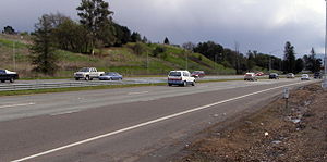
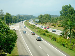
Roadway air dispersion modeling is the study of air pollutant transport from a roadway or other linear emitter. Computer models are required to conduct this analysis, because of the complex variables involved, including vehicle emission
Motor vehicle emissions
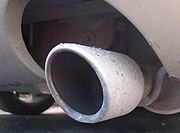
Motor vehicle emissions are composed of the by-products that comes out of the exhaust systems or other emissions such as gasoline evaporation...
s, vehicle speed, meteorology
Meteorology
Meteorology is the interdisciplinary scientific study of the atmosphere. Studies in the field stretch back millennia, though significant progress in meteorology did not occur until the 18th century. The 19th century saw breakthroughs occur after observing networks developed across several countries...
, and terrain
Terrain
Terrain, or land relief, is the vertical and horizontal dimension of land surface. When relief is described underwater, the term bathymetry is used...
geometry. Line source
Line source
A line source is a source of air, noise, water contamination or electromagnetic radiation that emanates from a linear geometry...
dispersion has been studied since at least the 1960s, when the regulatory framework in the United States
United States
The United States of America is a federal constitutional republic comprising fifty states and a federal district...
began requiring quantitative analysis of the air pollution consequences of major roadway and airport projects. By the early 1970s this subset of atmospheric dispersion models were being applied to real world cases of highway planning, even including some controversial court cases.
How the model works
The basic concept of the roadway air dispersion model is to calculate air pollutant levels in the vicinity of a highway or arterial roadway by considering them as line sources. The model takes into account source characteristics such as traffic volume, vehicle speeds, truck mix, and fleet emission controls; in addition, the roadway geometry, surrounding terrain and local meteorology are addressed. For example, many air quality standards require that certain near worst case meteorological conditions be applied.The calculations are sufficiently complex that a computer model is essential to arrive at authoritative results, although workbook type manuals have been developed as screening techniques. In some cases where results must be refereed (such as legal cases), model validation may be needed with field test data in the local setting; this step is not usually warranted, because the best models have been extensively validated over a wide spectrum of input data variables.
The product of the calculations is usually a set of isopleths or mapped contour lines either in plan view or cross sectional
Cross section (geometry)
In geometry, a cross-section is the intersection of a figure in 2-dimensional space with a line, or of a body in 3-dimensional space with a plane, etc...
view. Typically these might be stated as concentrations of carbon monoxide
Carbon monoxide
Carbon monoxide , also called carbonous oxide, is a colorless, odorless, and tasteless gas that is slightly lighter than air. It is highly toxic to humans and animals in higher quantities, although it is also produced in normal animal metabolism in low quantities, and is thought to have some normal...
, total reactive hydrocarbons, oxides of nitrogen, particulate or benzene
Benzene
Benzene is an organic chemical compound. It is composed of 6 carbon atoms in a ring, with 1 hydrogen atom attached to each carbon atom, with the molecular formula C6H6....
. The air quality scientist can run the model successively to study techniques of reducing adverse air pollutant concentrations
Air pollutant concentrations
Air pollutant concentrations, as measured or as calculated by air pollution dispersion modeling, must often be converted or corrected to be expressed as required by the regulations issued by various governmental agencies...
(for example, by redesigning roadway geometry, altering speed controls or limiting certain types of trucks). The model is frequently utilized in an Environmental Impact Statement
Environmental impact statement
An environmental impact statement , under United States environmental law, is a document required by the National Environmental Policy Act for certain actions "significantly affecting the quality of the human environment". An EIS is a tool for decision making...
involving a major new roadway or land use change which will induce new vehicular traffic.
History
The logical building block for this theory was the use of the GaussianGAUSSIAN
Gaussian is a computational chemistry software program initially released in 1970 by John Pople and his research group at Carnegie-Mellon University as Gaussian 70. It has been continuously updated since then...
air pollutant
Air pollution
Air pollution is the introduction of chemicals, particulate matter, or biological materials that cause harm or discomfort to humans or other living organisms, or cause damage to the natural environment or built environment, into the atmosphere....
dispersion equation for point source
Point source (pollution)
A point source of pollution is a single identifiable localized source of air, water, thermal, noise or light pollution. A point source has negligible extent, distinguishing it from other pollution source geometries. The sources are called point sources because in mathematical modeling, they can be...
s
. One of the early point source air pollutant plume
Plume (hydrodynamics)
In hydrodynamics, a plume is a column of one fluid or gas moving through another. Several effects control the motion of the fluid, including momentum, diffusion, and buoyancy...
dispersion equations was derived by Bosanquet and Pearson in 1936. Their equation did not include the effect of ground reflection of the pollutant plume. Sir Graham Sutton derived a point source air pollutant plume dispersion equation in 1947 which included the assumption of Gaussian distribution for the vertical and crosswind
Crosswind
A crosswind is any wind that has a perpendicular component to the line or direction of travel. In aviation, a crosswind is the component of wind that is blowing across the runway making landings and take-offs more difficult than if the wind were blowing straight down the runway...
dispersion of the plume and also addressed the effect of ground reflection of the plume. Further advances were made by G. A. Briggs in model refinement and validation and by D.B. Turner for his user-friendly workbook that included screening calculations which do not require a computer.
In seeing the need to develop a line source model to approach the study of roadway air pollution,
Michael Hogan and Richard Venti developed a closed form solution to integrating the point source equation in a series of publications.
Mathematical model
A mathematical model is a description of a system using mathematical concepts and language. The process of developing a mathematical model is termed mathematical modeling. Mathematical models are used not only in the natural sciences and engineering disciplines A mathematical model is a...
was completed for a line source by 1970, model refinement resulted in a “strip source”, emulating the horizontal extent of the roadway surface. This theory would be the precursor of area source
Area source (pollution)
Area sources are sources of pollution which emit a substance or radiation from a specified area.-Air pollution:For example, area sources of air pollution are air pollutant emission sources which operate within a certain locale. The U.S. Environmental Protection Agency has categorized 70 different...
dispersion models. But their focus was roadway simulation, so they proceeded with the development of a computer model by adding to the team Leda Patmore, a computer programmer in the field of atmospheric physics and satellite trajectory calculations. A working computer model was produced by late 1970; then the model was calibrated with carbon monoxide field measurements targeting from traffic on U.S. Route 101
U.S. Route 101
U.S. Route 101, or U.S. Highway 101, is an important north–south U.S. highway that runs through the states of California, Oregon, and Washington, on the West Coast of the United States...
in Sunnyvale, California
Sunnyvale, California
Sunnyvale is a city in Santa Clara County, California, United States. It is one of the major cities that make up the Silicon Valley located in the San Francisco Bay Area...
.
The ESL model received endorsement from the U.S. Environmental Protection Agency
United States Environmental Protection Agency
The U.S. Environmental Protection Agency is an agency of the federal government of the United States charged with protecting human health and the environment, by writing and enforcing regulations based on laws passed by Congress...
(EPA) in the form of a major grant to validate the model using actual roadway tests of tracer gas sulfur hexafluoride dispersion. That gas was chosen since it does not occur naturally or in vehicular emissions and provides a unique tracer for such dispersion studies. Part of the Environmental Protection Agency’s motives may have been to bring the model into public domain
Public domain
Works are in the public domain if the intellectual property rights have expired, if the intellectual property rights are forfeited, or if they are not covered by intellectual property rights at all...
. After a successful validation through the EPA research, the model was soon put to use in a variety of settings to forecast air pollution levels in the vicinity of roadways. The ESL group applied the model to the U.S. Route 101
U.S. Route 101
U.S. Route 101, or U.S. Highway 101, is an important north–south U.S. highway that runs through the states of California, Oregon, and Washington, on the West Coast of the United States...
bypass project in Cloverdale, California
Cloverdale, California
Cloverdale is a city in Sonoma County, California, United States. The San Francisco and North Pacific Railroad reached Cloverdale in 1872. The Cloverdale Rancheria of Pomo Indians of California is headquartered here...
, the extension of Interstate 66
Interstate 66
Interstate 66 is an Interstate Highway in the eastern United States. As indicated by its even route number, it runs in an east–west direction. Its western terminus is at Middletown, Virginia, at an intersection with Interstate 81; its eastern terminus is in Washington, D.C., at an...
through Arlington, Virginia, the widening of the New Jersey Turnpike
New Jersey Turnpike
The New Jersey Turnpike is a toll road in New Jersey, maintained by the New Jersey Turnpike Authority. According to the International Bridge, Tunnel and Turnpike Association, the Turnpike is the nation's sixth-busiest toll road and is among one of the most heavily traveled highways in the United...
through Raritan
Raritan, New Jersey
Raritan is a Borough in Somerset County, New Jersey, United States. As of the United States 2010 Census, the borough population was 6,881.-Geography:Raritan is located at ....
and East Brunswick, New Jersey, and several transportation projects in Boston
Boston
Boston is the capital of and largest city in Massachusetts, and is one of the oldest cities in the United States. The largest city in New England, Boston is regarded as the unofficial "Capital of New England" for its economic and cultural impact on the entire New England region. The city proper had...
for the Boston Transportation Planning Review.
By the early 1970s at least two other research groups were known to be actively developing some type to roadway air dispersion model: the Environmental Research and Technology group of Lexington, Massachusetts
Lexington, Massachusetts
Lexington is a town in Middlesex County, Massachusetts, United States. The population was 31,399 at the 2010 census. This town is famous for being the site of the first shot of the American Revolution, in the Battle of Lexington on April 19, 1775.- History :...
and Caltrans headquarters in Sacramento, California
Sacramento, California
Sacramento is the capital city of the U.S. state of California and the county seat of Sacramento County. It is located at the confluence of the Sacramento River and the American River in the northern portion of California's expansive Central Valley. With a population of 466,488 at the 2010 census,...
. The Caline model of Caltrans borrowed some of the technology from the ESL Inc. group, since Caltrans funded some of the early model application work in Cloverdale and other locations and was given rights to use parts of their model.
The theory
The resulting solution for an infinite line source is: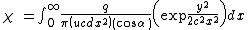
where:
x is the distance from the observer to the roadway
y is the height of the observer
u is the mean wind speed
α is the angle of tilt of the line source relative to the reference frame
c and d are the standard deviation of horizontal and vertical wind directions (measured in radians) respectively.
This equation was integrated into a closed form solution using the error function (erf), and variations in geometry can be performed to include the full infinite line, line segment, elevated line, or arc made from segments. In any case one can calculate three dimensional contours of resulting air pollutant concentrations and use the mathematical model
Mathematical model
A mathematical model is a description of a system using mathematical concepts and language. The process of developing a mathematical model is termed mathematical modeling. Mathematical models are used not only in the natural sciences and engineering disciplines A mathematical model is a...
to study alternative roadway designs, various assumptions of worst case meteorology or varying traffic conditions (for example, variations in truck mix, fleet emission controls, or vehicle speed.
The ESL research group also extended their model by introducing the area source concept of a vertical strip to simulate the mixing zone on the highway produced by vehicle turbulence
Turbulence
In fluid dynamics, turbulence or turbulent flow is a flow regime characterized by chaotic and stochastic property changes. This includes low momentum diffusion, high momentum convection, and rapid variation of pressure and velocity in space and time...
. This model too was validated in 1971 and showed good correlation with field test data.
Example applications of the model
Arlington Coalition on Transportation
The Arlington Coalition on Transportation is a citizens group formed to oppose the construction of Interstate 66 through Arlington, Virginia. The focal activity of ACT was the conduct of a lawsuit filed against the Virginia Department of Transportation in 1971 in district court...
(ACT) was the plaintiff
Plaintiff
A plaintiff , also known as a claimant or complainant, is the term used in some jurisdictions for the party who initiates a lawsuit before a court...
in an action against the Virginia Highway Commission over the extension of Interstate 66
Interstate 66
Interstate 66 is an Interstate Highway in the eastern United States. As indicated by its even route number, it runs in an east–west direction. Its western terminus is at Middletown, Virginia, at an intersection with Interstate 81; its eastern terminus is in Washington, D.C., at an...
through Arlington, Virginia , having filed a suit in the federal district court
United States district court
The United States district courts are the general trial courts of the United States federal court system. Both civil and criminal cases are filed in the district court, which is a court of law, equity, and admiralty. There is a United States bankruptcy court associated with each United States...
. The ESL model was used to produce calculations of air quality in the vicinity of the proposed highway. ACT won this case after a decision by the U.S. Fourth Circuit Court of Appeals. The court paid special attention to the plaintiff's expert calculations and testimony projecting that air quality levels would violate Federal ambient air quality standards as set forth in the Clean Air Act
Clean Air Act
A Clean Air Act is one of a number of pieces of legislation relating to the reduction of airborne contaminants, smog and air pollution in general. The use by governments to enforce clean air standards has contributed to an improvement in human health and longer life spans...
.
A second contentious case took place in East Brunswick, New Jersey where the New Jersey Turnpike Authority
New Jersey Turnpike Authority
The New Jersey Turnpike Authority is a state agency responsible for maintaining the New Jersey Turnpike and the Garden State Parkway...
planned a major widening of the Turnpike. Again the roadway air dispersion model was employed to predict levels of air pollution for residences, schools and parks near the Turnpike. After an initial hearing in Superior Court where the ESL model results were set forth, the judge ordered the Turnpike Authority to negotiate with the plaintiff, Concerned Citizens of East Brunswick and develop air quality mitigation for the adverse effects. The Turnpike Authority hired ERT as its expert, and the two research teams negotiated a settlement to this case using the newly created roadway air dispersion models.
More recent model refinements
The CALINE3 model is a steady-state Gaussian dispersion model designed to determine air pollution concentrations at receptor locations downwind of highways located in relatively uncomplicated terrain. CALINE3 is incorporated into the more elaborate CAL3QHC and CAL3QHCR models. CALINE3 is in widespread use due to its user friendly nature and promotion in governmental circles, but it falls short of analyzing the complexity of cases addressed by the original Hogan-Venti model. CAL3QHC and CAL3QHCR models are available in the FortranFortran
Fortran is a general-purpose, procedural, imperative programming language that is especially suited to numeric computation and scientific computing...
programming language. They have options to model either particulate matter or carbon monoxide
Carbon monoxide
Carbon monoxide , also called carbonous oxide, is a colorless, odorless, and tasteless gas that is slightly lighter than air. It is highly toxic to humans and animals in higher quantities, although it is also produced in normal animal metabolism in low quantities, and is thought to have some normal...
, and include algorithms to simulate queued traffic at signalized intersections http://www.epa.gov/scram001/dispersion_prefrec.htm#cal3qhc.
In addition, several more recent models have been developed that employ non-steady state Lagrangian puff algorithms. The HYROAD dispersion model has been developed through the National Cooperative Highway Research Program's Project 25-06, incorporating ROADWAY-2 model puff and steady-state plume algorithms (Rao et al., 2002).
The TRAQSIM model, developed as part of a Ph.D dissertation with support by the U.S. Department of Transportation's Volpe National Transportation Systems Center's Air Quality Facility is currently under the care of Wyle. The model incorporates dynamic vehicle behavior with a non-steady state Gaussian puff algorithm. Unlike HYROAD, TRAQSIM combines traffic simulation, second-by-second modal emissions, and Gaussian puff dispersion into a fully integrated system (a true simulation) that models individual vehicles as discrete moving sources. TRAQSIM was developed as a next generation model to be the successor to the current CALINE3 and CAL3QHC regulatory models. The next step in the development of TRAQSIM is to incorporate methods to model the dispersion of particulate matter (PM) and hazardous air pollutants (HAPs).
Several models have been developed that handle complex urban meteorology
Meteorology
Meteorology is the interdisciplinary scientific study of the atmosphere. Studies in the field stretch back millennia, though significant progress in meteorology did not occur until the 18th century. The 19th century saw breakthroughs occur after observing networks developed across several countries...
resulting from urban canyons
Urban canyon
An urban canyon is an artefact of an urban environment similar to a natural canyon. It is manifested by streets cutting through dense blocks of structures, especially skyscrapers, which causes a canyon effect...
and highway configurations. Examples include the Turner-Fairbank Highway Research Center's Canyon Plume Box model, now in version 3 (CPB-3), the National Environmental Research Institute of Denmark's Operational Street Pollution Model (OSPM), and the MICRO-CALGRID model, which includes photochemistry, allowing for both primary and secondary species to be modeled, Cornell University's CFD-VIT-RIT, which resolves vehicle-induced turbulence (VIT), road-induced turbulence (RIT) and chemical transformation of air pollutants using turbulence reacting flow models.
Recent applications in legal cases
Recent health literature indicating that residents near major roads face elevated rates of several adverse health outcomes has prompted legal dispute over the responsibility of transportation agencies to use roadway air dispersion models to characterize the impacts of new and expanded roadways, bus terminals, truck stops, and other sources.Recently, the Sierra Club
Sierra Club
The Sierra Club is the oldest, largest, and most influential grassroots environmental organization in the United States. It was founded on May 28, 1892, in San Francisco, California, by the conservationist and preservationist John Muir, who became its first president...
of Nevada sued the Nevada Department of Transportation
Nevada Department of Transportation
The Nevada Department of Transportation is a government agency in the U.S. state of Nevada. NDOT is responsible for maintaining and improving Nevada's highway system, which includes U.S. highways and Interstate highways within the state's boundaries. The department is notable for its...
and the Federal Highway Administration
Federal Highway Administration
The Federal Highway Administration is a division of the United States Department of Transportation that specializes in highway transportation. The agency's major activities are grouped into two "programs," the Federal-aid Highway Program and the Federal Lands Highway Program...
over its failure to assess the impact of the expansion of U.S. Route 95 in Las Vegas
U.S. Route 95 in Nevada
In the U.S. state of Nevada, U.S. Route 95 is a major U.S. highway traversing the state from north to south directly through Las Vegas and providing connections to both Carson City and Reno...
on neighborhood air quality.http://www.usatoday.com/news/nation/2003-03-06-vegas-highway-usat_x.htm The Sierra Club asserted that a supplemental Environmental Impact Statement
Environmental impact statement
An environmental impact statement , under United States environmental law, is a document required by the National Environmental Policy Act for certain actions "significantly affecting the quality of the human environment". An EIS is a tool for decision making...
should be issued to address emissions of hazardous air pollutants and particulate matter from new motor vehicle traffic. The plaintiffs asserted that modeling tools were available, including the Environmental Protection Agency
United States Environmental Protection Agency
The U.S. Environmental Protection Agency is an agency of the federal government of the United States charged with protecting human health and the environment, by writing and enforcing regulations based on laws passed by Congress...
's MOBILE6.2 model, the CALINE3 dispersion model, and other relevant models. The defendants won in the U.S. District Court under Judge Philip Pro, who ruled that the transportation agencies had acted in a manner that was not "arbitrary and capricious," despite the agencies' technical arguments regarding the lack of available modeling tools being contradicted by a number of peer-reviewed studies published in scientific journals (e.g. Korenstein and Piazza, Journal of Environmental Health, 2002). On appeal to the U.S. Ninth Circuit
United States Court of Appeals for the Ninth Circuit
The United States Court of Appeals for the Ninth Circuit is a U.S. federal court with appellate jurisdiction over the district courts in the following districts:* District of Alaska* District of Arizona...
, the Appeals Court stayed new construction on the highway pending the court's final decision. The Sierra Club and the defendants settled out of court, setting up a research program on the air quality impacts of U.S. Route 95 on nearby schools.
A number of other high-profile cases have prompted environmental groups to call for dispersion modeling to be used to assess the air quality impacts of new transportation projects on nearby communities, but to date state transportation agencies and the Federal Highways Administration has claimed that no tools are available, despite models and guidance available through EPA's Support Center for Regulatory Air Models (SCRAM).http://www.epa.gov/scram001
Among the more contentious of cases the Detroit Intermodal Freight Terminal and Detroit River International Crossing
Detroit River International Crossing
The Detroit River International Crossing , alternatively New International Trade Crossing , is a multi-national construction project and committee between Canada and the United States to create a new border crossing over the Detroit River...
(Michigan, USA), and the expansion of Interstate 70 East in Denver
Interstate 70 in Colorado
Interstate 70 is a transcontinental Interstate Highway in the United States, stretching from Cove Fort, Utah to Baltimore, Maryland. In Colorado, the highway traverses an east–west route across the center of the state. In western Colorado, the highway connects the metropolitan areas of Grand...
(Colorado , USA).
In all of these cases, community-based organizations have asserted that modeling tools are available, but transportation planning agencies have asserted that too much uncertainty exists in all of the steps. A major concern for community-based organizations has been transportation agencies' unwillingness to define the level of uncertainty that they are willing to tolerate in air quality analyses, how that compares to the Environmental Protection Agency
United States Environmental Protection Agency
The U.S. Environmental Protection Agency is an agency of the federal government of the United States charged with protecting human health and the environment, by writing and enforcing regulations based on laws passed by Congress...
's guideline on air quality models, which addresses uncertainty and accuracy in model use.http://www.epa.gov/scram001/guidance/guide/appw_05.pdf
See also
- Atmospheric dispersion modelingAtmospheric dispersion modelingAtmospheric dispersion modeling is the mathematical simulation of how air pollutants disperse in the ambient atmosphere. It is performed with computer programs that solve the mathematical equations and algorithms which simulate the pollutant dispersion...
- Bibliography of atmospheric dispersion modeling
- List of atmospheric dispersion models
- Global warmingGlobal warmingGlobal warming refers to the rising average temperature of Earth's atmosphere and oceans and its projected continuation. In the last 100 years, Earth's average surface temperature increased by about with about two thirds of the increase occurring over just the last three decades...
- Peak oilPeak oilPeak oil is the point in time when the maximum rate of global petroleum extraction is reached, after which the rate of production enters terminal decline. This concept is based on the observed production rates of individual oil wells, projected reserves and the combined production rate of a field...