

Rivers of Kent
Encyclopedia
Kent
Kent is a county in southeast England, and is one of the home counties. It borders East Sussex, Surrey and Greater London and has a defined boundary with Essex in the middle of the Thames Estuary. The ceremonial county boundaries of Kent include the shire county of Kent and the unitary borough of...
, England
England
England is a country that is part of the United Kingdom. It shares land borders with Scotland to the north and Wales to the west; the Irish Sea is to the north west, the Celtic Sea to the south west, with the North Sea to the east and the English Channel to the south separating it from continental...
.
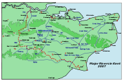
River Medway
This is the main river, whose catchment area covers almost 25% of the county. The detailed map has a diagram of that catchment area, which includes its main tributaries: the rivers Eden, Bourne (or Shode), Teise, Beult, Loose and Len.Tributaries of the River Medway
- The River EdenRiver Eden, KentThe River Eden in West Kent is a tributary of the River Medway. It travels through the Weald of Kent from the border with Surrey, rising from the source in Titsey parish, Surrey, grid reference TQ 420 551, about 350 metres north of Clacket Lane motorway services, and flowing...
- The River Bourne begins its course west of Oldbury HillOldbury hillfortOldbury hillfort is a large Iron Age hill fort near the village of Ightham, Kent, England.It covers the top of a hill that would have provided commanding views over one of the main routes in and out of the Weald and covers an area of 50 ha. A natural spring within the fort would have provided...
on the Greensand RidgeGreensand RidgeThe Greensand Ridge is an extensive, prominent, often heavily wooded, sandstone escarpment and range of hills in south-east England. It runs in a horseshoe shape around the Weald of Surrey, Sussex and Kent. It reaches its highest elevation, , at Leith Hill in Surrey—the second highest point...
in the parish of IghthamIghthamIghtham is a village in Kent, England, located approximately four miles east of Sevenoaks and six miles north of Tonbridge. The parish includes the hamlet of Ivy Hatch....
and enters the Medway upstream of East PeckhamEast PeckhamEast Peckham is a village in Kent, England, made up of nine hamlets and situated about east of Tonbridge on the River Medway. It was the centre for the hop growing industry in Kent and is still home to the Hop Farm which has the world's largest collection of Oast Houses.-History:The Domesday entry...
, near TonbridgeTonbridgeTonbridge is a market town in the English county of Kent, with a population of 30,340 in 2007. It is located on the River Medway, approximately 4 miles north of Tunbridge Wells, 12 miles south west of Maidstone and 29 miles south east of London...
. - The River TeiseRiver TeiseThe River Teise is a tributary of the River Medway in Kent, England. It begins in Dunorlan Park in Tunbridge Wells. and flows eastwards past Bayham Abbey and then through Lamberhurst...
begins in Dunorlan ParkDunorlan ParkDunorlan Park is a park and grounds in Royal Tunbridge Wells, UK.Totalling approximately 78 acres and containing a lake, the grounds were landscaped by Robert Marnock for Henry Reed, the merchant and philanthropist who owned the estate and the now-demolished house that once overlooked...
in Tunbridge WellsRoyal Tunbridge WellsRoyal Tunbridge Wells is a town in west Kent, England, about south-east of central London by road, by rail. The town is close to the border of the county of East Sussex...
and flows eastwards through LamberhurstLamberhurstLamberhurst is a village and civil parish in Kent although the latter parish was at first in both Kent and East Sussex. The line of the county border was adjusted following the Local Government Act 1894, which required that parish boundaries be aligned with counties...
, passing Bayham AbbeyLamberhurstLamberhurst is a village and civil parish in Kent although the latter parish was at first in both Kent and East Sussex. The line of the county border was adjusted following the Local Government Act 1894, which required that parish boundaries be aligned with counties...
. Here the small River Bewl , on which is the reservoir Bewl WaterBewl WaterBewl Water is a reservoir in the valley of the River Bewl , straddling the boundary between Kent and East Sussex. It is about 4 km south of Lamberhurst, Kent, England...
, joins the Teise. The Teise bifurcates 2km SW of MardenMarden, KentMarden is a village about 13 km south of Maidstone and civil parish in the Maidstone District of Kent, England. The parish is located on the flood plain of the River Beult near Maidstone. It is on the B2079 road linking the A229 Maidstone with the A21 at Flimwell. It has its own railway...
, the minor stream flows directly to Twyford Bridge, Yalding, while the major stream joins the River Beult at Hunton, 1.5km above Yalding. - The River BeultRiver BeultThe River Beult is a tributary of the River Medway. It has several sources west of Ashford, including one at Woodchurch. It then flows through Headcorn. At Hunton, above Yalding it is joined by the major stream of the River Teise. Town bridge lies 10¼ miles from Allington, it is the longest...
has its several sources west of AshfordAshford, KentAshford is a town in the borough of Ashford in Kent, England. In 2005 it was voted the fourth best place to live in the United Kingdom. It lies on the Great Stour river, the M20 motorway, and the South Eastern Main Line and High Speed 1 railways. Its agricultural market is one of the most...
, and then flows through HeadcornHeadcornHeadcorn is a village and civil parish in the Maidstone District of Kent, England. The parish is located on the floodplain of the River Beult south east of Maidstone....
and where it is joined by the major stream of the Teise. The river enters the Medway at YaldingYaldingYalding is a village and part of Yalding civil parish in the Maidstone District of Kent, England.The village is situated six miles south-west of Maidstone at a point where the Rivers Teise and Beult join the River Medway....
. - The River Loose is a relatively short river starting near LangleyLangley, KentLangley is a village and civil parish in the Maidstone District of Kent, England. The parish is located on the A274 road leading south from Maidstone to Headcorn .-History:...
south east of MaidstoneMaidstoneMaidstone is the county town of Kent, England, south-east of London. The River Medway runs through the centre of the town linking Maidstone to Rochester and the Thames Estuary. Historically, the river was a source and route for much of the town's trade. Maidstone was the centre of the agricultural...
running west through LooseLoose, KentLoose is a village some south of Maidstone, Kent, situated at the head of the Loose Valley. The village and the Loose Valley form the Loose Valley Conservation Area. The fast flowing River Loose which rises near Langley runs through the centre of the village and once supported a paper making...
and joining the Medway at TovilTovilTovil is a civil parish in the Borough of Maidstone, in Kent in the South East of England.It is a mixture of residential and industrial zoning, with an increase in commercial usage towards the centre of Maidstone, and more arable use on the outskirts....
. - The River Len has its source at a small watershedWater divideA drainage divide, water divide, divide or watershed is the line separating neighbouring drainage basins...
south of LenhamLenhamLenham is a market village in Kent situated on the southern edge of the North Downs, halfway between Maidstone and Ashford. The picturesque square in the village has two public houses , a couple of restaurants, and a tea-room....
. A nearby stream is one of the sources of the Great StourRiver Stour, KentThe River Stour is the river in Kent, England that flows into the English Channel at Pegwell Bay. Above Plucks Gutter, where the Little Stour joins it, the river is normally known as the Great Stour. The upper section of the river, above its confluence with the East Stour at Ashford is sometimes...
. The Len flows in a westerly direction and joins the Medway at MaidstoneMaidstoneMaidstone is the county town of Kent, England, south-east of London. The River Medway runs through the centre of the town linking Maidstone to Rochester and the Thames Estuary. Historically, the river was a source and route for much of the town's trade. Maidstone was the centre of the agricultural...
.
River Stour
The River Stour is also known as the Great Stour, especially above its confluence with the Little Stour at Plucks Gutter. Its catchment area covers the eastern part of Kent.Tributaries of the River Stour
- East Stour - rising near HytheHythe, KentHythe , is a small coastal market town on the edge of Romney Marsh, in the District of Shepway on the south coast of Kent. The word Hythe or Hithe is an Old English word meaning Haven or Landing Place....
to Ashford. - Little StourLittle StourThe Little Stour is one of the tributaries of the River Stour in the English county of Kent. The upper reaches of the river are better known as the Nailbourne, whilst the lower reaches were once known as the Seaton Navigation....
- north of Hythe to join the Great Stour at Plucks Gutter, north west of Canterbury. - River WantsumRiver WantsumThe River Wantsum is a tributary of the River Stour, in Kent, England. Formerly, the River Wantsum and the River Stour together formed the Wantsum Channel, which separated the Isle of Thanet from the mainland of Kent...
- part of the old Wantsum Channel separating the Isle of ThanetIsle of ThanetThe Isle of Thanet lies at the most easterly point of Kent, England. While in the past it was separated from the mainland by the nearly -wide River Wantsum, it is no longer an island ....
from Kent. - Whitewater DykeWhitewater DykeWhitewater Dyke is a tributary of the Great Stour river, joining with the East Stour and then the Great Stour at Pledge’s Mill at the bottom of East Hill in Ashford, Kent, England....
- running from ShadoxhurstShadoxhurstShadoxhurst is civil parish and a village on the Kent Weald, near Ashford in Kent, England located between the North Downs and Romney Marsh in wooded countryside and farmland...
to Ashford - Ruckinge DykeRuckinge DykeRuckinge Dyke is a tributary of the Great Stour, joining with the East Stour and then the Great Stour at Pledge’s Mill at the bottom of East Hill in Ashford, Kent, England....
- from north of HamstreetHamstreetHamstreet is a village in Kent, in South East England.The village is located some 6 miles south of Ashford on the A2070, the main road between Ashford and Hastings...
to Ashford - Aylesford StreamAylesford StreamAylesford Stream is a 5.4 kilometre long tributary of the Great Stour, joining at Pledge’s Mill at the bottom of East Hill in Ashford, Kent, England...
- its source is north of SevingtonSevingtonSevington is a small village and civil parish to the south-east of Ashford, Kent in England, with a population of about 113 in 1872, currently 354....
to WillesboroughWillesboroughWillesborough is a residential suburb on the eastern side of Ashford, Kent, England.-The area:The South Willesborough Dykes area, on the west bank of the East Stour river, is an area of sheep fields drained by dykes. The area is designated as the South Willesborough Dykes Site of Nature...
River Rother
A WealdWeald
The Weald is the name given to an area in South East England situated between the parallel chalk escarpments of the North and the South Downs. It should be regarded as three separate parts: the sandstone "High Weald" in the centre; the clay "Low Weald" periphery; and the Greensand Ridge which...
en river. It is included here since for part of its journey near Bodiam
Bodiam
Bodiam is a small village and civil parish in East Sussex, England, in the valley of the River Rother near to the villages of Sandhurst and Ewhurst Green. It is home to Bodiam Castle, a small range of houses, a pub opposite Bodiam Castle, and a restaurant...
it forms the boundary between Kent
Kent
Kent is a county in southeast England, and is one of the home counties. It borders East Sussex, Surrey and Greater London and has a defined boundary with Essex in the middle of the Thames Estuary. The ceremonial county boundaries of Kent include the shire county of Kent and the unitary borough of...
and East Sussex
East Sussex
East Sussex is a county in South East England. It is bordered by the counties of Kent, Surrey and West Sussex, and to the south by the English Channel.-History:...
.