
Whitewater Dyke
Encyclopedia
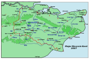
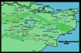
River Stour, Kent
The River Stour is the river in Kent, England that flows into the English Channel at Pegwell Bay. Above Plucks Gutter, where the Little Stour joins it, the river is normally known as the Great Stour. The upper section of the river, above its confluence with the East Stour at Ashford is sometimes...
, joining with the East Stour and then the Great Stour at Pledge’s Mill
Watermill
A watermill is a structure that uses a water wheel or turbine to drive a mechanical process such as flour, lumber or textile production, or metal shaping .- History :...
at the bottom of East Hill in Ashford, Kent
Ashford, Kent
Ashford is a town in the borough of Ashford in Kent, England. In 2005 it was voted the fourth best place to live in the United Kingdom. It lies on the Great Stour river, the M20 motorway, and the South Eastern Main Line and High Speed 1 railways. Its agricultural market is one of the most...
, England
England
England is a country that is part of the United Kingdom. It shares land borders with Scotland to the north and Wales to the west; the Irish Sea is to the north west, the Celtic Sea to the south west, with the North Sea to the east and the English Channel to the south separating it from continental...
.
The stream
Stream
A stream is a body of water with a current, confined within a bed and stream banks. Depending on its locale or certain characteristics, a stream may be referred to as a branch, brook, beck, burn, creek, "crick", gill , kill, lick, rill, river, syke, bayou, rivulet, streamage, wash, run or...
runs from its source near Shadoxhurst
Shadoxhurst
Shadoxhurst is civil parish and a village on the Kent Weald, near Ashford in Kent, England located between the North Downs and Romney Marsh in wooded countryside and farmland...
, 5.6 kilometres, to the East Stour in Willesborough
Willesborough
Willesborough is a residential suburb on the eastern side of Ashford, Kent, England.-The area:The South Willesborough Dykes area, on the west bank of the East Stour river, is an area of sheep fields drained by dykes. The area is designated as the South Willesborough Dykes Site of Nature...
.