
River Penk
Encyclopedia
The River Penk is a small river flowing though Staffordshire
, England
. Its course is mainly within South Staffordshire
, and it drains most of the northern part of that district, together with some adjoining areas of Cannock Chase
, Stafford
, Wolverhampton
, and Shropshire
. It flows into the River Sow
, which is a tributary of the River Trent
, so its waters flow ultimately into the North Sea
via the Humber Estuary.
from the toponym Penkridge
. This was understood to mean "ridge by the Penk"; hence the river was assumed to be the Penk. In reality the settlement name is from Celtic roots: pen crug, signifying the crest of a hill, or a main mound or tumulus. From this was derived the name of a Roman fort in the area, Pennocrucium, from which the present town takes its name. Margaret Gelling
has proposed a precise location for the mound, now destroyed by ploughing, that gave both the town and the river the names.
.
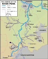
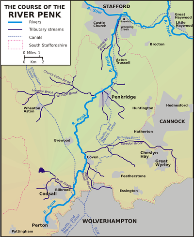
The Penk rises in the centre of the village of Perton
, South Staffordshire
, approximately three miles west-north-west of Wolverhampton
. The Penk itself flows entirely within Staffordshire, skirting around the Wolverhampton suburbs of Tettenhall
and Pendeford
, although it is joined on its right by a number of streams from within Wolverhampton, as well, on the left, the Moat Brook, which drains Oaken, Codsall and Bilbrook. It flows through the village of Coven
and is then joined by a major tributary, the Saredon
Brook, which drains the area around Cheslyn Hay
and Great Wyrley
.
It then flows north to the market town of Penkridge
, where it turns east and is joined by the Whiston Brook - a tributary which drains a substantial area, stretching out into Shropshire. Turning north again, it flows across the plain, past Acton Trussell
and into a marshy area, where numerous drains have been constructed and brooks canalised to contain flooding. Passing on to Baswich
on the outskirts of Stafford
, it joins the River Sow
, which itself soon empties into the River Trent
- a major river which will empty ultimately via the Humber
into the North Sea
.
, Trout
, Perch
, Pike
and, reportedly, Barbel
. The Penk is perhaps at its most beautiful between the villages of Brewood
and Penkridge
. Here the river meanders gently through the picturesque Staffordshire farmland and plays host to a variety of waterfowl and mammals.
The Pendeford Mill Nature Reserve is situated on the Penk to the north of Pendeford, within South Staffordshire but owned by the City of Wolverhampton. A 24-hectare area of lakes, wetland, ancient grass meadow and woodland, it occupies a part of the site of a large former country estate, Pendeford Hall, which possessed an osier bed and watermill, and dated to the 13th century. It was developed by Wolverhampton council after 1976 and is now host to a wide range of wildlife, particularly birds. An environmentally-sensitive area on the edge of a conurbation, it is open to the public only by advance booking or on specific open days.
Staffordshire
Staffordshire is a landlocked county in the West Midlands region of England. For Eurostat purposes, the county is a NUTS 3 region and is one of four counties or unitary districts that comprise the "Shropshire and Staffordshire" NUTS 2 region. Part of the National Forest lies within its borders...
, England
England
England is a country that is part of the United Kingdom. It shares land borders with Scotland to the north and Wales to the west; the Irish Sea is to the north west, the Celtic Sea to the south west, with the North Sea to the east and the English Channel to the south separating it from continental...
. Its course is mainly within South Staffordshire
South Staffordshire
South Staffordshire is a local government district in Staffordshire, England. The district lies to the north and west of Wolverhampton and the West Midlands, bordering Shropshire to the west and Worcestershire to the south...
, and it drains most of the northern part of that district, together with some adjoining areas of Cannock Chase
Cannock Chase (district)
Cannock Chase is a local government district in England. It covers a large part of Cannock Chase forest and the towns of Cannock, Rugeley and Hednesford.There are several parish and town councils in the district:* Rugeley* Hednesford...
, Stafford
Stafford (borough)
Stafford is a local government district with borough status in Staffordshire in England. It is named after and includes the town of Stafford. It also includes the smaller town of Stone and numerous villages....
, Wolverhampton
Wolverhampton
Wolverhampton is a city and metropolitan borough in the West Midlands, England. For Eurostat purposes Walsall and Wolverhampton is a NUTS 3 region and is one of five boroughs or unitary districts that comprise the "West Midlands" NUTS 2 region...
, and Shropshire
Shropshire
Shropshire is a county in the West Midlands region of England. For Eurostat purposes, the county is a NUTS 3 region and is one of four counties or unitary districts that comprise the "Shropshire and Staffordshire" NUTS 2 region. It borders Wales to the west...
. It flows into the River Sow
River Sow
The River Sow is a tributary of the River Trent in Staffordshire, England.The river rises to the south of Newcastle-under-Lyme and flows south to become the major river through Stafford. It also flows near Bishop's Offley and Tixall. At Baswich it is joined by the River Penk, before meeting the...
, which is a tributary of the River Trent
River Trent
The River Trent is one of the major rivers of England. Its source is in Staffordshire on the southern edge of Biddulph Moor. It flows through the Midlands until it joins the River Ouse at Trent Falls to form the Humber Estuary, which empties into the North Sea below Hull and Immingham.The Trent...
, so its waters flow ultimately into the North Sea
North Sea
In the southwest, beyond the Straits of Dover, the North Sea becomes the English Channel connecting to the Atlantic Ocean. In the east, it connects to the Baltic Sea via the Skagerrak and Kattegat, narrow straits that separate Denmark from Norway and Sweden respectively...
via the Humber Estuary.
Etymology
The name "Penk" is actually a back-formationBack-formation
In etymology, back-formation is the process of creating a new lexeme, usually by removing actual or supposed affixes. The resulting neologism is called a back-formation, a term coined by James Murray in 1889...
from the toponym Penkridge
Penkridge
Penkridge is a market town and ancient parish in Staffordshire, England with a population of 7,836 . Many locals refer to it as a village, although it has a long history as an ecclesiastical and commercial centre. Its main distinction in the Middle Ages was as the site of an important collegiate...
. This was understood to mean "ridge by the Penk"; hence the river was assumed to be the Penk. In reality the settlement name is from Celtic roots: pen crug, signifying the crest of a hill, or a main mound or tumulus. From this was derived the name of a Roman fort in the area, Pennocrucium, from which the present town takes its name. Margaret Gelling
Margaret Gelling
Margaret Joy Gelling, OBE was an English toponymist, Fellow of St Hilda's College, Oxford, and member of the Society of Antiquaries of London and the British Academy....
has proposed a precise location for the mound, now destroyed by ploughing, that gave both the town and the river the names.
Course
The general course of the Penk is a descent from the mid-Severn sandstone section of the Midlands Plateau to the Cheshire-Shropshire-Staffordshire plain. Along much of its length, the Penk is shadowed to within a few miles by the Staffordshire and Worcestershire CanalStaffordshire and Worcestershire Canal
The Staffordshire and Worcestershire Canal is a narrow navigable canal in the English Midlands, passing through the counties of Staffordshire and Worcestershire....
.
The Penk rises in the centre of the village of Perton
Perton
Perton is a large village and civil parish located in Staffordshire, England. It lies to the south of Codsall, and to the west of the city of Wolverhampton.-Perton:...
, South Staffordshire
South Staffordshire
South Staffordshire is a local government district in Staffordshire, England. The district lies to the north and west of Wolverhampton and the West Midlands, bordering Shropshire to the west and Worcestershire to the south...
, approximately three miles west-north-west of Wolverhampton
Wolverhampton
Wolverhampton is a city and metropolitan borough in the West Midlands, England. For Eurostat purposes Walsall and Wolverhampton is a NUTS 3 region and is one of five boroughs or unitary districts that comprise the "West Midlands" NUTS 2 region...
. The Penk itself flows entirely within Staffordshire, skirting around the Wolverhampton suburbs of Tettenhall
Tettenhall
Tettenhall is a historic part of the city of Wolverhampton, England. The name Tettenhall is probably derived from Teotta's Halh, Teotta being a person's name and Halh being a sheltered position...
and Pendeford
Pendeford
Pendeford is a suburb of Wolverhampton, West Midlands, England. It is situated NNW of the city centre, adjacent to the border with Staffordshire, within the Oxley ward of Wolverhampton City Council.- Name and origins :...
, although it is joined on its right by a number of streams from within Wolverhampton, as well, on the left, the Moat Brook, which drains Oaken, Codsall and Bilbrook. It flows through the village of Coven
Coven, Staffordshire
Coven is a small village in the district of South Staffordshire, England, near to the border with Wolverhampton. Together with Brewood it forms part of the parish of Brewood & Coven.-Etymology:...
and is then joined by a major tributary, the Saredon
Saredon
Saredon is a civil parish in South Staffordshire district, Staffordshire, England, situated to the north east of Wolverhampton, West Midlands, and to the south west of Cannock....
Brook, which drains the area around Cheslyn Hay
Cheslyn Hay
Cheslyn Hay is a former mining village in south Staffordshire, between Cannock and Walsall.Station Street is the main street with some small shops.A major employer in the village is B.S. Eaton Ltd, a manufacturer of concrete products...
and Great Wyrley
Great Wyrley
Great Wyrley is a parish and town in South Staffordshire, England, with a population of 11,236 at the 2001 census.-Etymology:The word "Wyrley" derives from two Old English words: wir and leah. Wir meant "bog myrtle," and leah meant "woodland clearing," suggesting that Great Wyrley was, at genesis,...
.
It then flows north to the market town of Penkridge
Penkridge
Penkridge is a market town and ancient parish in Staffordshire, England with a population of 7,836 . Many locals refer to it as a village, although it has a long history as an ecclesiastical and commercial centre. Its main distinction in the Middle Ages was as the site of an important collegiate...
, where it turns east and is joined by the Whiston Brook - a tributary which drains a substantial area, stretching out into Shropshire. Turning north again, it flows across the plain, past Acton Trussell
Acton Trussell
Acton Trussell is a village in the English county of Staffordshire. It is known as Actone in the Domesday Book. Located around 4 miles southeast of Stafford, it is an affluent village, with many large homes but few local amenities...
and into a marshy area, where numerous drains have been constructed and brooks canalised to contain flooding. Passing on to Baswich
Baswich
Baswich is an estate in the south eastern side of Stafford in the parish of Berkswich. It is situated next to Weeping Cross but should not be confused with Weeping Cross....
on the outskirts of Stafford
Stafford
Stafford is the county town of Staffordshire, in the West Midlands region of England. It lies approximately north of Wolverhampton and south of Stoke-on-Trent, adjacent to the M6 motorway Junction 13 to Junction 14...
, it joins the River Sow
River Sow
The River Sow is a tributary of the River Trent in Staffordshire, England.The river rises to the south of Newcastle-under-Lyme and flows south to become the major river through Stafford. It also flows near Bishop's Offley and Tixall. At Baswich it is joined by the River Penk, before meeting the...
, which itself soon empties into the River Trent
River Trent
The River Trent is one of the major rivers of England. Its source is in Staffordshire on the southern edge of Biddulph Moor. It flows through the Midlands until it joins the River Ouse at Trent Falls to form the Humber Estuary, which empties into the North Sea below Hull and Immingham.The Trent...
- a major river which will empty ultimately via the Humber
Humber
The Humber is a large tidal estuary on the east coast of Northern England. It is formed at Trent Falls, Faxfleet, by the confluence of the tidal River Ouse and the tidal River Trent. From here to the North Sea, it forms part of the boundary between the East Riding of Yorkshire on the north bank...
into the North Sea
North Sea
In the southwest, beyond the Straits of Dover, the North Sea becomes the English Channel connecting to the Atlantic Ocean. In the east, it connects to the Baltic Sea via the Skagerrak and Kattegat, narrow straits that separate Denmark from Norway and Sweden respectively...
.
Wildlife
The river contains many species of fish including ChubEuropean chub
The European chub , sometimes called the round chub, fat chub, chevin, pollard or simply "the" chub, is a freshwater fish of the family Cyprinidae...
, Trout
Brown trout
The brown trout and the sea trout are fish of the same species....
, Perch
European perch
The European perch, Perca fluviatilis, is a predatory species of perch found in Europe and Asia. In some areas it is known as the redfin perch or English perch, and it is often known simply as perch. The species is a popular quarry for anglers and has been widely introduced beyond its native area,...
, Pike
Northern Pike
The northern pike , is a species of carnivorous fish of the genus Esox...
and, reportedly, Barbel
Barbel (fish species)
Barbels are group of small carp-like freshwater fish, almost all of the genus Barbus. They are usually found in gravel and rocky-bottomed slow-flowing waters with high dissolved oxygen content. A typical adult barbel will range from 25 to 100 cm in length and weigh anywhere between 200 g...
. The Penk is perhaps at its most beautiful between the villages of Brewood
Brewood
Brewood refers both to a settlement, which was once a town but is now a village, in South Staffordshire, England, and to the civil parish of which it is the centre. Located around , Brewood village lies near the River Penk, eight miles north of Wolverhampton city centre and eleven miles south of...
and Penkridge
Penkridge
Penkridge is a market town and ancient parish in Staffordshire, England with a population of 7,836 . Many locals refer to it as a village, although it has a long history as an ecclesiastical and commercial centre. Its main distinction in the Middle Ages was as the site of an important collegiate...
. Here the river meanders gently through the picturesque Staffordshire farmland and plays host to a variety of waterfowl and mammals.
The Pendeford Mill Nature Reserve is situated on the Penk to the north of Pendeford, within South Staffordshire but owned by the City of Wolverhampton. A 24-hectare area of lakes, wetland, ancient grass meadow and woodland, it occupies a part of the site of a large former country estate, Pendeford Hall, which possessed an osier bed and watermill, and dated to the 13th century. It was developed by Wolverhampton council after 1976 and is now host to a wide range of wildlife, particularly birds. An environmentally-sensitive area on the edge of a conurbation, it is open to the public only by advance booking or on specific open days.
Tributaries
The main tributaries of the Penk, travelling south from its confluence with the Sow, are:- the Deepmoor Drain, a canalised brook which collects the water from a network of brooks and drains to the east of the lower Penk, and runs parallel to it for several kilometres, before emptying into it just before its confluence with the Sow.
- the Rickerscote Drain, which performs a similar function in the marshy areas to the west of the Penk, running roughly parallel to it, and channelling the waters of the Rising Brook, the Silkmore and the Pen Pleck Drain into the river.
- the Pothooks Brook, a small river that originates to the north-west of Penkridge.
- the Whiston Brook, which joins the Penk just above Penkridge, and channels into it the waters of the Longnor, Church Eaton and Wheaton Aston Brooks, draining an area that extends into Shropshire in the west.
- the Saredon Brook, which drains a substantial area to the east, around Cheslyn Hay and Great Wyrley, and joins the Penk north of Coven.
- the Watershead Brook, which joins the Penk just south of Coven, and drains the FordhousesFordhousesFordhouses is a suburb of Wolverhampton, West Midlands, England. It is situated to the north of the city centre, adjacent to the border with Staffordshire, within the Bushbury North ward of Wolverhampton City Council...
and BushburyBushburyBushbury is a suburb of Wolverhampton, West Midlands, England. It lies two miles north-east of Wolverhampton city centre, divided between the Bushbury North and Bushbury South and Low Hill wards.- Place name and history :...
areas of Wolverhampton. - the Moat Brook, which channels water from numerous smaller brooks and drains around OakenOakenOaken is a small village in Staffordshire, England. The first mention of the Oaken place-name, was in 1086 when it was listed in the Domesday book as Ache. Its origin appears to be from the Old English, ācum - the oaks....
, CodsallCodsallCodsall is a large village in the South Staffordshire district of Staffordshire, England. It is situated north west of the city of Wolverhampton.-History:...
and Bilbrook, and joins the Penk by the PendefordPendefordPendeford is a suburb of Wolverhampton, West Midlands, England. It is situated NNW of the city centre, adjacent to the border with Staffordshire, within the Oxley ward of Wolverhampton City Council.- Name and origins :...
Mill Nature Reserve.