

River Little Ouse
Encyclopedia
The Little Ouse is a river in the east of England, a tributary
of the River Great Ouse
. For much of its length it defines the boundary between Norfolk
and Suffolk
.
It rises east of Thelnetham
, very close to the source of the River Waveney
- which flows eastwards while the Little Ouse flows west. The village with the curious name of Blo' Norton
owes this name to the river - it was earlier known as Norton Bell-'eau, from being situated near this 'fair stream'. The course continues through Rushford
, Thetford, Brandon
, and Hockwold; it joins the Great Ouse north of Littleport in Cambridgeshire
. The total length is about 37 miles (59.5 km).
The river is currently navigable from the Great Ouse to a point 2 miles (3.2 km) above Brandon.
in which they flow; the Little Ouse westwards and the Waveney, eastwards. It has a broad, fen
ny bottom, lies at an altitude of up to 85 feet (25.9 m) and both rivers rise in the fen alongside the B1113 road, between South Lopham and Redgrave. . The explanation of this oddity is that the valley was formed, not by these rivers but by water spilling from Lake Fenland. This was a periglacial
lake of the Devensian glacial, fifteen or twenty thousand years ago. The ice sheet
closed the natural drainage from the Vale of Pickering
, the Humber
and The Wash
so that a lake of a complex shape formed in the Vale of Pickering, the Yorkshire Ouse
valley, the lower Trent
valley and the Fenland
basin
. This valley was its spillway
into the southern North Sea
basin, thence to the English Channel
basin, which at the time, contained no sea
.
The downstream end of the Little Ouse has changed much over the centuries. In the Fens and Norfolk Marshland, it was quite possible for the course of a river to change as the result of a flooding episode so it is not surprising to find that the Great Ouse used to enter The Wash by way of the Old Croft River, the Wellstream and Wisbech
(the Ouse beach). The modern lower Great Ouse was then the lower part of the Little Ouse. On this occasion, the change was artificial. The 17th century drainers under Cornelius Vermuyden
dug the Old Bedford River
between the Great Ouse at Earith
and what had hitherto been the Little Ouse at Denver
. A link was made for the Great Ouse between Littleport 1 and the Little Ouse at Brandon Creek and both the drainage and the navigation
were directed towards King's Lynn
rather than Wisbech.
has designated the section from Thetford to Brandon, where it flows through the afforested
Breckland
, as a Flood Warning Area.
The lower part of the river crosses over the Cut-off Channel in a concrete aqueduct. The Channel is a 25 miles (40.2 km) drain which runs from Barton Mills to Denver along the south-eastern edge of the Fens, and was constructed in the 1950s and 1960s. During times of flood it carries the head waters of the River Lark
, the River Wissey
and the Little Ouse to Denver Sluice. On its south side are two sluices, so that flood water from the upper river can be diverted into the cut-off channel and the section between there and the Great Ouse isolated. The flood banks on this lower section are up to half a mile wide so that the meandering river will form a large lake.
Nearer the mouth of the river, the Brandon Engine was the main outlet for the drainage of the northern half of Burnt Fen
from 1830 until 1958. The original steam engine was replaced in 1892, by a new engine that could pump 75 tons per minute. That engine was replaced by a 250 horse power oil engine in late 1925, supplied by Blackstone and Company, which drove a 42 inches (106.7 cm) Gwynne rotary pump. The pump could discharge 150 tons per minute against a head of 18 feet (5.5 m), and lasted for 30 years. When a replacement was considered in the 1950s, the Commissioners of the Burnt Fen were faced with the problem that the White House Drain which supplied it had become bigger and more unstable as the ground surface had shrunk, and the engine sat at the top of a hill, rather than at the lowest point on the northern Fen. Consequently, a new electric pumping station was constructed at Whitehall on the River Great Ouse
, the flow in the drain reversed, and the pumping station decommissioned.
to Santon Downham bridge. There are references to its use by boats carrying goods to Brandon as early as the 13th century, and barges are known to have reached Thetford
, some 6 miles (9.7 km) beyond Santon Downham when the river was tidal. Stone from Barnack, used in the construction of Thetford Priory in the 12th century, was almost certainly moved along the river, and improvements to the channel were authorised by the Commissioners of Sewers as early as 1575. Further documentary evidence confirms that it was navigable as far as Thetford in 1664.
However, water levels dropped when Denver Sluice was built on the River Great Ouse. An Act of Parliament
authorised the Corporation of Thetford to make improvements to the river in 1670, but they were unable to carry out the work, and so the Rt Hon Henry, Earl of Arlington made the improvements, and was assigned the tolls as a result. A series of staunches were built, to hold back the water and raise the levels, but they were too far apart to be effective. The rights of the navigation were given to Thetford Corporation by Henry's daughter Isabella in 1696, and the Corporation had to build a new staunch near Thetford in 1742, in order to maintain water levels in the town.
By 1750, disputes were arising, since all the original Commissioners were dead, and they had failed to appoint replacements. A new Act of Parliament
was sought and obtained in 1751, which appointed new Commissioners. Immediately, Thetford Corporation made improvements to the river, constructing staunches at Thetford, Thetford Middle, Turfpool, Croxton, Santon, Brandon and Sheepwash. An eighth staunch was built later at Crosswater, where Lakenheath Lode joins the river. A further Act was obtained in 1789, which regularised the collection of tolls on the whole river by Thetford Corporation. They rebuilt the seven staunches between 1827 and 1835, and the £955 of income received from the navigation in 1833 accounted for over 90 per cent of the total income of the Corporation.
The 1770s saw a grand plan to build a canal from the Little Ouse at Thetford to the River Stort
at Bishops Stortford. With a spur to Cambridge
, this would have enabled goods to reach London
by canal from much of East Anglia. Although the capital cost could not be justified, it was not until the 1850s and the advent of the railways that the scheme was finally abandoned.
Tolls reached a record £1,728 in 1845, when over 15,000 tonnes of coal were carried, but the arrival of the railways, in the form of a line from Norwich to Brandon, and an extension of the Eastern Counties Railway
from Newport to Brandon, both opened on the same day in 1845, started the rapid decline of the navigation. Tolls had fallen to £439 by 1849. The tolls were leased to private individuals from 1850, but an attempt to transfer £320 to the Council finance committee from the navigation in 1859 resulted in nearly a year of legal wrangling, and ultimately the money was repaid in 1860. The state of the navigation declined steadily, although there was still commercial traffic, and a 25 feet (7.6 m) paddle steamer ran trips to Cambridge and around the local waterways in the 1880s.
 Repairs were again necessary in the 1890s, but with no funds available, the navigation committee asked Fisons, who ran a 50 feet (15.2 m) screw tug called Speedwell to tow lighters to King's Lynn, for an advance on their tolls to fund the work. This arrangement continued, and kept the navigation open for some years. When Henry de Salis visited it in 1904, he reported that most of the staunches were out of order, and that it was in poor condition. The Bedford Level Commissioners kept the weed removed from the lower section, and the South Level Commissioners maintained Crosswater Staunch, but commercial traffic had ceased by the start of the First World War. Responsibility for the river passed to the Great Ouse Catchment Board with the passing of the Land Drainage Act of 1930, and they removed the staunches, replacing those at Thetford and at Brandon with sluices. Responsibility changed again with the formation of the Environment Agency
in 1995.
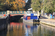
The navigable river is mainly on the same level, with a single lock, which was opened in 1995, at Brandon just a short distance from Brandon bridge. The lock is 13 feet (4 m) wide but only 39 feet (11.9 m) long, and so is not suitable for many narrow boats, although boats up to 79 feet (24.1 m) long can be turned just below the lock, which is less than 0.5 mile (0.80467 km) from Brandon village.
There is a campaign to re-open the river for navigation to Thetford, and the Environment Agency commissioned consultants in 2003 to look at the feasibility of such a project. The report suggested that four locks would be required on this section. The head of navigation was effectively extended in 2008 when the 2.5 miles (4 km) section from Brandon Bridge to Santon Downham was made more accessible to boaters by the construction of moorings just below Santon Downham bridge, which are now managed by the Great Ouse Boating Association. Beyond the bridge the river is only accessible to canoes and dingies, due to the presence of rocks on the river bed.
, whose headquarters are in the adjacent Nunnery buildings.
Tributary
A tributary or affluent is a stream or river that flows into a main stem river or a lake. A tributary does not flow directly into a sea or ocean...
of the River Great Ouse
River Great Ouse
The Great Ouse is a river in the east of England. At long, it is the fourth-longest river in the United Kingdom. The river has been important for navigation, and for draining the low-lying region through which it flows. Its course has been modified several times, with the first recorded being in...
. For much of its length it defines the boundary between Norfolk
Norfolk
Norfolk is a low-lying county in the East of England. It has borders with Lincolnshire to the west, Cambridgeshire to the west and southwest and Suffolk to the south. Its northern and eastern boundaries are the North Sea coast and to the north-west the county is bordered by The Wash. The county...
and Suffolk
Suffolk
Suffolk is a non-metropolitan county of historic origin in East Anglia, England. It has borders with Norfolk to the north, Cambridgeshire to the west and Essex to the south. The North Sea lies to the east...
.
It rises east of Thelnetham
Thelnetham
Thelnetham is a village and civil parish in the St Edmundsbury district of Suffolk in eastern England. Located on the southern bank of the River Little Ouse , six miles west of Diss, in 2005 its population was 230....
, very close to the source of the River Waveney
River Waveney
The Waveney is a river which forms the border between Suffolk and Norfolk, England, for much of its length within The Broads.-Course:The source of the River Waveney is a ditch on the east side of the B1113 road between the villages of Redgrave, Suffolk and South Lopham, Norfolk...
- which flows eastwards while the Little Ouse flows west. The village with the curious name of Blo' Norton
Blo' Norton
Blo' Norton is a village and civil parish in the Breckland district of Norfolk, England, on the River Little Ouse, not far from Diss. The parish had a population of 270 in approximately 100 households, according to the 2001 census....
owes this name to the river - it was earlier known as Norton Bell-'eau, from being situated near this 'fair stream'. The course continues through Rushford
Rushford, Norfolk
Rushford is a small village in the English county of Norfolk. It is situated on the north bank of the River Little Ouse, east of the town of Thetford and south of the main A1066 road. The river forms the boundary between Norfolk and Suffolk and, until 1894, Rushford was in both counties...
, Thetford, Brandon
Brandon, Suffolk
Brandon is a small town and civil parish in the English county of Suffolk. It is in the Forest Heath local government district.Brandon is located in the Breckland area on the border of Suffolk with the adjoining county of Norfolk...
, and Hockwold; it joins the Great Ouse north of Littleport in Cambridgeshire
Cambridgeshire
Cambridgeshire is a county in England, bordering Lincolnshire to the north, Norfolk to the northeast, Suffolk to the east, Essex and Hertfordshire to the south, and Bedfordshire and Northamptonshire to the west...
. The total length is about 37 miles (59.5 km).
The river is currently navigable from the Great Ouse to a point 2 miles (3.2 km) above Brandon.
Its origin
The most distinctive feature of the headwaters of the Little Ouse and the Waveney is the valleyValley
In geology, a valley or dale is a depression with predominant extent in one direction. A very deep river valley may be called a canyon or gorge.The terms U-shaped and V-shaped are descriptive terms of geography to characterize the form of valleys...
in which they flow; the Little Ouse westwards and the Waveney, eastwards. It has a broad, fen
Fen
A fen is a type of wetland fed by mineral-rich surface water or groundwater. Fens are characterised by their water chemistry, which is neutral or alkaline, with relatively high dissolved mineral levels but few other plant nutrients...
ny bottom, lies at an altitude of up to 85 feet (25.9 m) and both rivers rise in the fen alongside the B1113 road, between South Lopham and Redgrave. . The explanation of this oddity is that the valley was formed, not by these rivers but by water spilling from Lake Fenland. This was a periglacial
Periglacial
Periglacial is an adjective originally referring to places in the edges of glacial areas, but it has later been widely used in geomorphology to describe any place where geomorphic processes related to freezing of water occur...
lake of the Devensian glacial, fifteen or twenty thousand years ago. The ice sheet
Ice sheet
An ice sheet is a mass of glacier ice that covers surrounding terrain and is greater than 50,000 km² , thus also known as continental glacier...
closed the natural drainage from the Vale of Pickering
Pickering, North Yorkshire
Pickering is an ancient market town and civil parish in the Ryedale district of the county of North Yorkshire, England, on the border of the North York Moors National Park. It sits at the foot of the Moors, overlooking the Vale of Pickering to the south...
, the Humber
Humber
The Humber is a large tidal estuary on the east coast of Northern England. It is formed at Trent Falls, Faxfleet, by the confluence of the tidal River Ouse and the tidal River Trent. From here to the North Sea, it forms part of the boundary between the East Riding of Yorkshire on the north bank...
and The Wash
The Wash
The Wash is the square-mouthed bay and estuary on the northwest margin of East Anglia on the east coast of England, where Norfolk meets Lincolnshire. It is among the largest estuaries in the United Kingdom...
so that a lake of a complex shape formed in the Vale of Pickering, the Yorkshire Ouse
River Ouse, Yorkshire
The River Ouse is a river in North Yorkshire, England. The river is formed from the River Ure at Cuddy Shaw Reach near Linton-on-Ouse, about 6 miles downstream of the confluence of the River Swale with the River Ure...
valley, the lower Trent
River Trent
The River Trent is one of the major rivers of England. Its source is in Staffordshire on the southern edge of Biddulph Moor. It flows through the Midlands until it joins the River Ouse at Trent Falls to form the Humber Estuary, which empties into the North Sea below Hull and Immingham.The Trent...
valley and the Fenland
The Fens
The Fens, also known as the , are a naturally marshy region in eastern England. Most of the fens were drained several centuries ago, resulting in a flat, damp, low-lying agricultural region....
basin
Drainage basin
A drainage basin is an extent or an area of land where surface water from rain and melting snow or ice converges to a single point, usually the exit of the basin, where the waters join another waterbody, such as a river, lake, reservoir, estuary, wetland, sea, or ocean...
. This valley was its spillway
Spillway
A spillway is a structure used to provide the controlled release of flows from a dam or levee into a downstream area, typically being the river that was dammed. In the UK they may be known as overflow channels. Spillways release floods so that the water does not overtop and damage or even destroy...
into the southern North Sea
North Sea
In the southwest, beyond the Straits of Dover, the North Sea becomes the English Channel connecting to the Atlantic Ocean. In the east, it connects to the Baltic Sea via the Skagerrak and Kattegat, narrow straits that separate Denmark from Norway and Sweden respectively...
basin, thence to the English Channel
English Channel
The English Channel , often referred to simply as the Channel, is an arm of the Atlantic Ocean that separates southern England from northern France, and joins the North Sea to the Atlantic. It is about long and varies in width from at its widest to in the Strait of Dover...
basin, which at the time, contained no sea
Sea
A sea generally refers to a large body of salt water, but the term is used in other contexts as well. Most commonly, it means a large expanse of saline water connected with an ocean, and is commonly used as a synonym for ocean...
.
The downstream end of the Little Ouse has changed much over the centuries. In the Fens and Norfolk Marshland, it was quite possible for the course of a river to change as the result of a flooding episode so it is not surprising to find that the Great Ouse used to enter The Wash by way of the Old Croft River, the Wellstream and Wisbech
Wisbech
Wisbech is a market town, inland port and civil parish with a population of 20,200 in the Fens of Cambridgeshire. The tidal River Nene runs through the centre of the town and is spanned by two bridges...
(the Ouse beach). The modern lower Great Ouse was then the lower part of the Little Ouse. On this occasion, the change was artificial. The 17th century drainers under Cornelius Vermuyden
Cornelius Vermuyden
Sir Cornelius Wasterdyk Vermuyden was a Dutch engineer who introduced Dutch reclamation methods to Britain, and made the first important attempts to drain The Fens of East Anglia.-Life:...
dug the Old Bedford River
Old Bedford River
The Old Bedford River is an artificial, partial diversion of the waters of the River Great Ouse in the Fens of Cambridgeshire, England. It was named after the fourth Earl of Bedford who contracted with the local Commission of Sewers to drain the Great Level of the Fens beginning in 1630.The idea of...
between the Great Ouse at Earith
Earith
Earith is a village in the Fens of Cambridgeshire, England, south of Chatteris and east of Huntingdon. At Earith, two artificial diversion channels of the River Great Ouse, the Old Bedford River and the New Bedford River, leave the river on a course to Denver Sluice near Downham Market, where they...
and what had hitherto been the Little Ouse at Denver
Denver, Norfolk
Denver is a village and civil parish in the English county of Norfolk. It is located on the River Great Ouse, 1 mile south of the small town of Downham Market, 14 miles south of the larger town of King's Lynn, and 37 miles west of the city of Norwich.The civil parish has an area of...
. A link was made for the Great Ouse between Littleport 1 and the Little Ouse at Brandon Creek and both the drainage and the navigation
were directed towards King's Lynn
King's Lynn
King's Lynn is a sea port and market town in the ceremonial county of Norfolk in the East of England. It is situated north of London and west of Norwich. The population of the town is 42,800....
rather than Wisbech.
Flood precautions
The Environment AgencyEnvironment Agency
The Environment Agency is a British non-departmental public body of the Department for Environment, Food and Rural Affairs and an Assembly Government Sponsored Body of the Welsh Assembly Government that serves England and Wales.-Purpose:...
has designated the section from Thetford to Brandon, where it flows through the afforested
Thetford Forest
Thetford Forest is the largest lowland pine forest in Britain, Thetford Forest Park is located in a region straddling the north of Suffolk and the south of Norfolk in England...
Breckland
Breckland
The Breckland as a landscape region is an unusual natural habitat of England. It comprises the gorse-covered sandy heath that exists in the north of the county of Suffolk and the south of Norfolk. An area of considerable interest for its unusual flora and fauna, it lies to the south east of another...
, as a Flood Warning Area.
The lower part of the river crosses over the Cut-off Channel in a concrete aqueduct. The Channel is a 25 miles (40.2 km) drain which runs from Barton Mills to Denver along the south-eastern edge of the Fens, and was constructed in the 1950s and 1960s. During times of flood it carries the head waters of the River Lark
River Lark
The River Lark is a river in England, which crosses the border between Suffolk and Cambridgeshire. It is a tributary of the River Great Ouse, and was extended when that river was re-routed as part of drainage improvements. It is thought to have been used for navigation since Roman times, and...
, the River Wissey
River Wissey
The River Wissey is a river in Norfolk, eastern England. It rises near Bradenham, and flows for nearly to join the River Great Ouse at Fordham...
and the Little Ouse to Denver Sluice. On its south side are two sluices, so that flood water from the upper river can be diverted into the cut-off channel and the section between there and the Great Ouse isolated. The flood banks on this lower section are up to half a mile wide so that the meandering river will form a large lake.
Nearer the mouth of the river, the Brandon Engine was the main outlet for the drainage of the northern half of Burnt Fen
Burnt Fen
Burnt Fen is an area of low-lying land crossed by the A1101 road between Littleport in Cambridgeshire and Mildenhall in Suffolk, England. It is surrounded on three sides by rivers, and consists of prime agricultural land, with sparse settlement...
from 1830 until 1958. The original steam engine was replaced in 1892, by a new engine that could pump 75 tons per minute. That engine was replaced by a 250 horse power oil engine in late 1925, supplied by Blackstone and Company, which drove a 42 inches (106.7 cm) Gwynne rotary pump. The pump could discharge 150 tons per minute against a head of 18 feet (5.5 m), and lasted for 30 years. When a replacement was considered in the 1950s, the Commissioners of the Burnt Fen were faced with the problem that the White House Drain which supplied it had become bigger and more unstable as the ground surface had shrunk, and the engine sat at the top of a hill, rather than at the lowest point on the northern Fen. Consequently, a new electric pumping station was constructed at Whitehall on the River Great Ouse
River Great Ouse
The Great Ouse is a river in the east of England. At long, it is the fourth-longest river in the United Kingdom. The river has been important for navigation, and for draining the low-lying region through which it flows. Its course has been modified several times, with the first recorded being in...
, the flow in the drain reversed, and the pumping station decommissioned.
Navigation
The river is currently navigable for 16.6 miles (26.7 km) from its junction with the River Great OuseRiver Great Ouse
The Great Ouse is a river in the east of England. At long, it is the fourth-longest river in the United Kingdom. The river has been important for navigation, and for draining the low-lying region through which it flows. Its course has been modified several times, with the first recorded being in...
to Santon Downham bridge. There are references to its use by boats carrying goods to Brandon as early as the 13th century, and barges are known to have reached Thetford
Thetford
Thetford is a market town and civil parish in the Breckland district of Norfolk, England. It is on the A11 road between Norwich and London, just south of Thetford Forest. The civil parish, covering an area of , has a population of 21,588.-History:...
, some 6 miles (9.7 km) beyond Santon Downham when the river was tidal. Stone from Barnack, used in the construction of Thetford Priory in the 12th century, was almost certainly moved along the river, and improvements to the channel were authorised by the Commissioners of Sewers as early as 1575. Further documentary evidence confirms that it was navigable as far as Thetford in 1664.
However, water levels dropped when Denver Sluice was built on the River Great Ouse. An Act of Parliament
Act of Parliament
An Act of Parliament is a statute enacted as primary legislation by a national or sub-national parliament. In the Republic of Ireland the term Act of the Oireachtas is used, and in the United States the term Act of Congress is used.In Commonwealth countries, the term is used both in a narrow...
authorised the Corporation of Thetford to make improvements to the river in 1670, but they were unable to carry out the work, and so the Rt Hon Henry, Earl of Arlington made the improvements, and was assigned the tolls as a result. A series of staunches were built, to hold back the water and raise the levels, but they were too far apart to be effective. The rights of the navigation were given to Thetford Corporation by Henry's daughter Isabella in 1696, and the Corporation had to build a new staunch near Thetford in 1742, in order to maintain water levels in the town.
By 1750, disputes were arising, since all the original Commissioners were dead, and they had failed to appoint replacements. A new Act of Parliament
Act of Parliament
An Act of Parliament is a statute enacted as primary legislation by a national or sub-national parliament. In the Republic of Ireland the term Act of the Oireachtas is used, and in the United States the term Act of Congress is used.In Commonwealth countries, the term is used both in a narrow...
was sought and obtained in 1751, which appointed new Commissioners. Immediately, Thetford Corporation made improvements to the river, constructing staunches at Thetford, Thetford Middle, Turfpool, Croxton, Santon, Brandon and Sheepwash. An eighth staunch was built later at Crosswater, where Lakenheath Lode joins the river. A further Act was obtained in 1789, which regularised the collection of tolls on the whole river by Thetford Corporation. They rebuilt the seven staunches between 1827 and 1835, and the £955 of income received from the navigation in 1833 accounted for over 90 per cent of the total income of the Corporation.
The 1770s saw a grand plan to build a canal from the Little Ouse at Thetford to the River Stort
River Stort
River Stort is a tributary of the River Lea which it joins at Hoddesdon, Hertfordshire at Feildes Weir-Overview:River Stort takes its name from Bishop's Stortford, a town through which it flows. It was given the name in the 16th century....
at Bishops Stortford. With a spur to Cambridge
Cambridge
The city of Cambridge is a university town and the administrative centre of the county of Cambridgeshire, England. It lies in East Anglia about north of London. Cambridge is at the heart of the high-technology centre known as Silicon Fen – a play on Silicon Valley and the fens surrounding the...
, this would have enabled goods to reach London
London
London is the capital city of :England and the :United Kingdom, the largest metropolitan area in the United Kingdom, and the largest urban zone in the European Union by most measures. Located on the River Thames, London has been a major settlement for two millennia, its history going back to its...
by canal from much of East Anglia. Although the capital cost could not be justified, it was not until the 1850s and the advent of the railways that the scheme was finally abandoned.
Tolls reached a record £1,728 in 1845, when over 15,000 tonnes of coal were carried, but the arrival of the railways, in the form of a line from Norwich to Brandon, and an extension of the Eastern Counties Railway
Eastern Counties Railway
The Eastern Counties Railway was an early English railway company incorporated in 1836. It was intended to link London with Ipswich via Colchester, and then on to Norwich and Yarmouth. Construction began in late March 1837 on the first nine miles, at the London end of the line.Construction was...
from Newport to Brandon, both opened on the same day in 1845, started the rapid decline of the navigation. Tolls had fallen to £439 by 1849. The tolls were leased to private individuals from 1850, but an attempt to transfer £320 to the Council finance committee from the navigation in 1859 resulted in nearly a year of legal wrangling, and ultimately the money was repaid in 1860. The state of the navigation declined steadily, although there was still commercial traffic, and a 25 feet (7.6 m) paddle steamer ran trips to Cambridge and around the local waterways in the 1880s.
Environment Agency
The Environment Agency is a British non-departmental public body of the Department for Environment, Food and Rural Affairs and an Assembly Government Sponsored Body of the Welsh Assembly Government that serves England and Wales.-Purpose:...
in 1995.
The navigable river is mainly on the same level, with a single lock, which was opened in 1995, at Brandon just a short distance from Brandon bridge. The lock is 13 feet (4 m) wide but only 39 feet (11.9 m) long, and so is not suitable for many narrow boats, although boats up to 79 feet (24.1 m) long can be turned just below the lock, which is less than 0.5 mile (0.80467 km) from Brandon village.
There is a campaign to re-open the river for navigation to Thetford, and the Environment Agency commissioned consultants in 2003 to look at the feasibility of such a project. The report suggested that four locks would be required on this section. The head of navigation was effectively extended in 2008 when the 2.5 miles (4 km) section from Brandon Bridge to Santon Downham was made more accessible to boaters by the construction of moorings just below Santon Downham bridge, which are now managed by the Great Ouse Boating Association. Beyond the bridge the river is only accessible to canoes and dingies, due to the presence of rocks on the river bed.
Points of interest
Immediately upstream of Nuns Bridges, Thetford, the river was widened to form Thetford swimming pool, which remained in use until the 1970's when an indoor pool was built. The steps and rail of the pool are still visible. Immediately upstream of the swimming pool, the river runs through Nunnery Lakes Reserve, a bird reserve owned and operated by the British Trust for OrnithologyBritish Trust for Ornithology
The British Trust for Ornithology is an organisation founded in 1932 for the study of birds in the British Isles.-Activities:The BTO carries out research into the lives of birds, chiefly by conducting population and breeding surveys and by bird ringing, largely carried out by a large number of...
, whose headquarters are in the adjacent Nunnery buildings.
Footnote
- Note 1: The old, winding course of the Great Ouse was from the bottom of the map, along the green-dotted footpath, just south of the roundabout, along the Holmes River, westwards through the northern fringe of Littleport and northwards between the two brown 0 metre contour lines, until it passed out of the top of the map.
See also
- Rivers of the United Kingdom
- Little Ouse Headwaters ProjectLittle Ouse Headwaters ProjectThe Little Ouse Headwaters Project was set up in 2002 by local residents to promote conservation and enjoyment of the fenland habitats bordering the upper reaches of the River Little Ouse, which lies on the Norfolk-Suffolk border...