

River Lark
Encyclopedia
The River Lark is a river
in England, which crosses the border between Suffolk
and Cambridgeshire
. It is a tributary
of the River Great Ouse
, and was extended when that river was re-routed as part of drainage improvements. It is thought to have been used for navigation since Roman times, and improvements were made in 1638 and in the early 1700s, when locks and staunches were built. The upper terminus was on the northern edge of Bury St Edmunds, but a new dock was opened near the railway station after the Eastern Union Railway
opened its line in 1846.
The navigation was officially abandoned in 1888, but despite this, commercial use of the river continued until 1928. Following acquisition by the Great Ouse Catchment Board, locks at Barton Mills and Icklingham were rebuilt in the 1960s, but were isolated when the A11 road bridge was lowered soon afterwards. It now has one operational lock at Isleham, and can be navigated to Jude's Ferry.
, to the south of Bury St Edmunds in Suffolk, it flows through Bury, Mildenhall
and Prickwillow
, and joins the Great Ouse south of Littleport in Cambridgeshire. It is about 31 miles (49.9 km) long, of which 10.1 miles (16.3 km) is navigable.
The upper river is an important focus for prehistoric activity, particularly relating to the Neolithic enclosure at Fornham All Saints. Culford School
is situated on the north bank at West Stow, and the river plays an important part in school life, being used for activities such as punting and rowing
.
Just above Barton Mills, a side weir connects the river to the start of the Cut-off Channel, a 25-mile (40 km) drain running from there to Denver along the south-eastern edge of the Fens, which was constructed in the 1950s and 1960s. During times of flood it carries the head waters of the River Lark, the River Wissey
and the Little Ouse
to Denver Sluice on the River Great Ouse.
Below Barton Mills, the mill stream at Mildenhall marks the start of a footpath which follows the north bank of the river to Isleham, after which there are footpaths and drove roads on both sides of the river to its junction with the Great Ouse. There is a weir at King's Staunch, after which comes Jude's Ferry, the current head of navigation, where boats at least 60 feet (18.3 m) in length can be turned. A magnificent hoard of late Roman silver was discovered at nearby Thistley Green in 1942, and the 34 pieces
, which included bowls, spoons, dishes and goblets, were declared to be Treasure trove
and are now in the British Museum
.
The stretch from Jude's Ferry to Isleham includes several pill-boxes
, which were constructed during World War II
to defend against invasion. Above the start of the lock cut is a memorial to the famous Baptist preacher Charles Spurgeon
, who was baptised
in the river on 3 May 1850. The site, where a chain ferry once crossed the river, and another near the weir were used for public baptisms until 1970. Isleham itself has three pubs, all dating from the 17th century, some shops and a large marina. There was an outbreak of cholera here in the 1850s, when over 500 people were "living in hollows" as a result of poverty which affected many fenland villages. In medieval times, Isleham was an important port with three quays. Remains of a Roman villa and over 6,000 Bronze-Age artefacts, which are now in the Moyse's Hall Museum at Bury St Edmunds, indicate that it has been a centre of occupation since antiquity.
From Isleham to Prickwillow, the river flows for almost 4 miles (6.4 km) in an artificial cut, thought to have been constructed by the Romans, and joined the River Great Ouse at Prickwillow until 1830. The Great Ouse was then diverted, and its old course occupied by the Lark. There are a number of pumping stations on the banks of this section, including the Lark Engine, which has been the main outlet for the drainage of the southern part of Burnt Fen
since 1842. Many of the surrounding ditches once flowed into the river by gravity, but the draining of the fens has resulted in the land surface dropping, and the water must now be raised by up to 16 feet (4.9 m) from the ditches to the river. At Mile End, two pumping stations sit one above the other, indicating the progressive sinking of the land. Prickwillow is home to the Museum of Fen Pumping Engines, itself once a working pumping station, and now holding several engines which were used in the draining of the Fens.
Prickwillow vicarage also demonstrates the shrinking of the land. Its ground floor rooms were originally the cellars, and the two steps leading to the front door have been replaced by nine. Below Prickwillow, the river is crossed by the Ely to Norwich railway line. The final 0.9 miles (1.4 km) of the river's course are quite straight, as the river flows through another artificial channel. At its junction with the Great Ouse, the channel is crossed by a road which was formerly the A10, which ran along the banks of the Great Ouse at this point on its route from Ely to Littleport, but this section has been bypassed by a new alignment of the road further to the west.
, from whom boat owners must obtain a licence in order to use the waterway. The Agency have designated the sections from Sicklesmere
to Bury St Edmunds, and from Fornham St Martin
to Isleham
as Flood Warning Areas.
, a building material quarried from pits near Isleham, and stone for the building of Bury St Edmunds Abbey was carried to the site along the river. The first records of plans to improve the river for navigation date from 1635, when Henry Lambe sought to make it navigable from the Ouse to Bury St Edmunds. Although his plans were approved by a commission, there was local opposition, and it was December 1637 before he was granted a licence from the King to complete the work. By 1700, the upper reaches were again in disrepair, and Henry Ashley obtained powers to improve the river from Worlington to below Mildenhall Mill, and to make it navigable from there to East Gate bridge in Bury St Edmunds. In addition to a schedule of tolls for the carriage of commodities, special provision was made so that some coal could be carried without incurring tolls, to assist the poor of Bury St Edmunds, and "gentlemen and persons of quality" did not have to pay for the use of the river by pleasure boats.
Ashley built 14 staunches and 11 sluices, the latter almost certainly referring to pound locks
. In 1716, tolls amounted to £475, although the work was unfinished, and Ashley estimated that a further £800 was required to complete it. Disputes with millers were recorded in 1720 and 1722, and ownership of the navigation was disputed on Ashley's death. The Master of the Rolls
gave it to Joshua and Joanna Palmer in 1742, but receipts were meagre, at around £267 per year, and the maintenance carried out was barely sufficient. Ownership had passed to their son, Ashley Palmer, by 1781, when the navigation made a profit of £274. In 1790, there were plans for a 31 miles (49.9 km) link from Bury St Edmunds to the River Orwell
at Mistley, which John Rennie surveyed, but it involved heavy engineering work, including a 2420 yards (2,212.8 m) tunnel, and the estimated cost of £75,000 could not be raised. Palmer died in 1792, and the river was managed by Susanna Palmer, his widow.
 The costs of maintenance were high, for in 1807 tolls of £1,348 were received, but profits were less than one third of that amount. Recognising that a large investment was needed to keep the river profitable, an attempt was made in 1817 to sell it to the Duke of Norfolk for £12,000, but this came to nothing. The original Commissioners appointed under the Act obtained in 1700 had failed to appoint any more Commissioners, and so new Commissioners were authorised by an Act of Parliament
obtained in 1817, with powers to raise the tolls to pay for the maintenance of the navigation. Little work was done, although a new lock and staunch were built at Isleham under provisions of the Eau Brink Act of 1821. The South Level Commissioners, who had been formed by an Act of Parliament obtained in 1827, took over control of the lower river, and re-routed it to join the new course of the Great Ouse which had been diverted into a cut to the west of its original route. Trade on the upper river was increasingly difficult, as a result of obstructions and shoals in the channel. The lighters used on the river often had to be partially unloaded at Prickwillow, to allow them to navigate the shallower sections.
Control of the river above Isleham was inherited by Sir Thomas Cullum when Susanna Palmer died. He rebuilt most of the locks and staunches in the 1830s, resulting in increased trade in coal and general merchandise which originated from Kings Lynn, but success was short lived, as the Eastern Union Railway
opened a line from Ipswich
to Bury St Edmunds in 1846, and decline was immediate. In the 1850s, with the Fornham to Bury section impassible, the Bury St Edmunds Navigation Company proposed a scheme to reopen the river to Bury railway station. Their prospectus stated that the Eastern Union Railway had been managing the river for seven years, but little changed, as they failed to raise a working capital of £20,000, and by the 1860s, the route above Mildenhall was ruined.
Abandonment of the river as a navigation was authorised by the Railway and Canal Traffic Act of 1888. The River Arun
in West Sussex
was the only other river abandoned by this Act. Despite this, the Eastern Counties Navigation and Transport Co Ltd bought the river from Lee Brook to Bury St Edmunds in 1890, made Tuddenham Mill Stream navigable, repaired locks and staunches on the main river, and re-opened it in September 1894. The company was bankrupt by December, and the Icklingham to Bury St Edmunds section closed again. Some trading continued on the lower reaches, but commercial carrying ceased after 1928. Ownership of the river passed to the Great Ouse Catchment Board with the passing of the Land Drainage Act of 1930. They rebuilt Barton Mills and Icklingham locks in the 1960s, but the bridge carrying the A11 road at Barton Mills was lowered soon afterwards, and the present head of navigation is at Jude's Ferry.
There is a second, much shorter, River Lark also in Suffolk which flows into the River Deben
at Martlesham
.
River
A river is a natural watercourse, usually freshwater, flowing towards an ocean, a lake, a sea, or another river. In a few cases, a river simply flows into the ground or dries up completely before reaching another body of water. Small rivers may also be called by several other names, including...
in England, which crosses the border between Suffolk
Suffolk
Suffolk is a non-metropolitan county of historic origin in East Anglia, England. It has borders with Norfolk to the north, Cambridgeshire to the west and Essex to the south. The North Sea lies to the east...
and Cambridgeshire
Cambridgeshire
Cambridgeshire is a county in England, bordering Lincolnshire to the north, Norfolk to the northeast, Suffolk to the east, Essex and Hertfordshire to the south, and Bedfordshire and Northamptonshire to the west...
. It is a tributary
Tributary
A tributary or affluent is a stream or river that flows into a main stem river or a lake. A tributary does not flow directly into a sea or ocean...
of the River Great Ouse
River Great Ouse
The Great Ouse is a river in the east of England. At long, it is the fourth-longest river in the United Kingdom. The river has been important for navigation, and for draining the low-lying region through which it flows. Its course has been modified several times, with the first recorded being in...
, and was extended when that river was re-routed as part of drainage improvements. It is thought to have been used for navigation since Roman times, and improvements were made in 1638 and in the early 1700s, when locks and staunches were built. The upper terminus was on the northern edge of Bury St Edmunds, but a new dock was opened near the railway station after the Eastern Union Railway
Eastern Union Railway
The Eastern Union Railway was an early English railway, initially sanctioned by Act of Parliament on 19 July 1844, with authorised capital of £200,000 to build from Ipswich to Colchester. Further Acts of 21 July 1845 and 26 June 1846 authorised further increases in capital of £50,000 and £20,000...
opened its line in 1846.
The navigation was officially abandoned in 1888, but despite this, commercial use of the river continued until 1928. Following acquisition by the Great Ouse Catchment Board, locks at Barton Mills and Icklingham were rebuilt in the 1960s, but were isolated when the A11 road bridge was lowered soon afterwards. It now has one operational lock at Isleham, and can be navigated to Jude's Ferry.
Course
Rising at Bradfield CombustBradfield Combust
Bradfield Combust is a village in Suffolk, England. According to Eilert Ekwall the meaning of the village name of "Bradfield" is "the wide fold" . "Combust" is derived from "Combusta" Latin fem. = burnt or burned; medieval syn...
, to the south of Bury St Edmunds in Suffolk, it flows through Bury, Mildenhall
Mildenhall, Suffolk
Mildenhall is a small market town and civil parish in Suffolk, England. It is run by Forest Heath District Council and has a population of 9,906 people. The town is near the A11 and is located north-west of county town, Ipswich. The large Royal Air Force base, RAF Mildenhall as well as RAF...
and Prickwillow
Prickwillow
Originally a small hamlet on the banks of the River Great Ouse, but now on the banks of the River Lark since re-organisation of the river system, the village of Prickwillow has an estimated mid-2005 population of 440...
, and joins the Great Ouse south of Littleport in Cambridgeshire. It is about 31 miles (49.9 km) long, of which 10.1 miles (16.3 km) is navigable.
The upper river is an important focus for prehistoric activity, particularly relating to the Neolithic enclosure at Fornham All Saints. Culford School
Culford School
Culford School is a coeducational HMC and IAPS public school for pupils age 3–18. Founded in 1881, it is situated in Culford, four miles north of Bury St Edmunds in Suffolk, England.-History:...
is situated on the north bank at West Stow, and the river plays an important part in school life, being used for activities such as punting and rowing
Watercraft rowing
Watercraft rowing is the act of propelling a boat using the motion of oars in the water. The difference between paddling and rowing is that with rowing the oars have a mechanical connection with the boat whereas with paddling the paddles are hand-held with no mechanical connection.This article...
.
Just above Barton Mills, a side weir connects the river to the start of the Cut-off Channel, a 25-mile (40 km) drain running from there to Denver along the south-eastern edge of the Fens, which was constructed in the 1950s and 1960s. During times of flood it carries the head waters of the River Lark, the River Wissey
River Wissey
The River Wissey is a river in Norfolk, eastern England. It rises near Bradenham, and flows for nearly to join the River Great Ouse at Fordham...
and the Little Ouse
River Little Ouse
The Little Ouse is a river in the east of England, a tributary of the River Great Ouse. For much of its length it defines the boundary between Norfolk and Suffolk....
to Denver Sluice on the River Great Ouse.
Below Barton Mills, the mill stream at Mildenhall marks the start of a footpath which follows the north bank of the river to Isleham, after which there are footpaths and drove roads on both sides of the river to its junction with the Great Ouse. There is a weir at King's Staunch, after which comes Jude's Ferry, the current head of navigation, where boats at least 60 feet (18.3 m) in length can be turned. A magnificent hoard of late Roman silver was discovered at nearby Thistley Green in 1942, and the 34 pieces
Mildenhall Treasure
The West Row Treasure is a major hoard of highly decorated Roman silver tableware from the fourth-century AD, found at West Row, near Mildenhall in the English county of Suffolk...
, which included bowls, spoons, dishes and goblets, were declared to be Treasure trove
Treasure trove
A treasure trove may broadly be defined as an amount of money or coin, gold, silver, plate, or bullion found hidden underground or in places such as cellars or attics, where the treasure seems old enough for it to be presumed that the true owner is dead and the heirs undiscoverable...
and are now in the British Museum
British Museum
The British Museum is a museum of human history and culture in London. Its collections, which number more than seven million objects, are amongst the largest and most comprehensive in the world and originate from all continents, illustrating and documenting the story of human culture from its...
.
The stretch from Jude's Ferry to Isleham includes several pill-boxes
British hardened field defences of World War II
British hardened field defences of World War II were small fortified structures constructed as a part of British anti-invasion preparations. They were popularly known as pillboxes by reference to their shape.-Design and development:...
, which were constructed during World War II
World War II
World War II, or the Second World War , was a global conflict lasting from 1939 to 1945, involving most of the world's nations—including all of the great powers—eventually forming two opposing military alliances: the Allies and the Axis...
to defend against invasion. Above the start of the lock cut is a memorial to the famous Baptist preacher Charles Spurgeon
Charles Spurgeon
Charles Haddon Spurgeon was a large British Particular Baptist preacher who remains highly influential among Christians of different denominations, among whom he is still known as the "Prince of Preachers"...
, who was baptised
Baptism
In Christianity, baptism is for the majority the rite of admission , almost invariably with the use of water, into the Christian Church generally and also membership of a particular church tradition...
in the river on 3 May 1850. The site, where a chain ferry once crossed the river, and another near the weir were used for public baptisms until 1970. Isleham itself has three pubs, all dating from the 17th century, some shops and a large marina. There was an outbreak of cholera here in the 1850s, when over 500 people were "living in hollows" as a result of poverty which affected many fenland villages. In medieval times, Isleham was an important port with three quays. Remains of a Roman villa and over 6,000 Bronze-Age artefacts, which are now in the Moyse's Hall Museum at Bury St Edmunds, indicate that it has been a centre of occupation since antiquity.
From Isleham to Prickwillow, the river flows for almost 4 miles (6.4 km) in an artificial cut, thought to have been constructed by the Romans, and joined the River Great Ouse at Prickwillow until 1830. The Great Ouse was then diverted, and its old course occupied by the Lark. There are a number of pumping stations on the banks of this section, including the Lark Engine, which has been the main outlet for the drainage of the southern part of Burnt Fen
Burnt Fen
Burnt Fen is an area of low-lying land crossed by the A1101 road between Littleport in Cambridgeshire and Mildenhall in Suffolk, England. It is surrounded on three sides by rivers, and consists of prime agricultural land, with sparse settlement...
since 1842. Many of the surrounding ditches once flowed into the river by gravity, but the draining of the fens has resulted in the land surface dropping, and the water must now be raised by up to 16 feet (4.9 m) from the ditches to the river. At Mile End, two pumping stations sit one above the other, indicating the progressive sinking of the land. Prickwillow is home to the Museum of Fen Pumping Engines, itself once a working pumping station, and now holding several engines which were used in the draining of the Fens.
Prickwillow vicarage also demonstrates the shrinking of the land. Its ground floor rooms were originally the cellars, and the two steps leading to the front door have been replaced by nine. Below Prickwillow, the river is crossed by the Ely to Norwich railway line. The final 0.9 miles (1.4 km) of the river's course are quite straight, as the river flows through another artificial channel. At its junction with the Great Ouse, the channel is crossed by a road which was formerly the A10, which ran along the banks of the Great Ouse at this point on its route from Ely to Littleport, but this section has been bypassed by a new alignment of the road further to the west.
Management
The river is managed and maintained by the Environment AgencyEnvironment Agency
The Environment Agency is a British non-departmental public body of the Department for Environment, Food and Rural Affairs and an Assembly Government Sponsored Body of the Welsh Assembly Government that serves England and Wales.-Purpose:...
, from whom boat owners must obtain a licence in order to use the waterway. The Agency have designated the sections from Sicklesmere
Sicklesmere
Sicklesmere is a village in Suffolk, England. Located on the A134 around a mile south of Bury St Edmunds, the village is divided between the civil parishes of Little and Great Whelnetham.-History:...
to Bury St Edmunds, and from Fornham St Martin
Fornham St Martin
Fornham St Martin is a village and civil parish in the St Edmundsbury district of Suffolk in eastern England. Located on the northern outskirts of Bury St Edmunds off east and west from the A134, in 2005 its population was 1300...
to Isleham
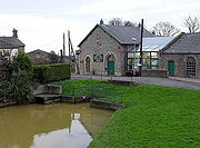
Isleham
Isleham is a small village and civil parish in the English county of Cambridgeshire. It is part of the Fens.-Geography:Isleham is located in the Fens of south-east Cambridgeshire. The western parish boundary is formed by the Crooked Ditch, the eastern boundary largely by the Lea Brook and the north...
as Flood Warning Areas.
Navigation
The Lark is thought to have been used by the Romans for the carriage of clunchClunch
Clunch is a term for traditional building material used mainly in eastern England and Normandy. It is a term which encompasses a wide variety of materials, often locally variable....
, a building material quarried from pits near Isleham, and stone for the building of Bury St Edmunds Abbey was carried to the site along the river. The first records of plans to improve the river for navigation date from 1635, when Henry Lambe sought to make it navigable from the Ouse to Bury St Edmunds. Although his plans were approved by a commission, there was local opposition, and it was December 1637 before he was granted a licence from the King to complete the work. By 1700, the upper reaches were again in disrepair, and Henry Ashley obtained powers to improve the river from Worlington to below Mildenhall Mill, and to make it navigable from there to East Gate bridge in Bury St Edmunds. In addition to a schedule of tolls for the carriage of commodities, special provision was made so that some coal could be carried without incurring tolls, to assist the poor of Bury St Edmunds, and "gentlemen and persons of quality" did not have to pay for the use of the river by pleasure boats.
Ashley built 14 staunches and 11 sluices, the latter almost certainly referring to pound locks
Lock (water transport)
A lock is a device for raising and lowering boats between stretches of water of different levels on river and canal waterways. The distinguishing feature of a lock is a fixed chamber in which the water level can be varied; whereas in a caisson lock, a boat lift, or on a canal inclined plane, it is...
. In 1716, tolls amounted to £475, although the work was unfinished, and Ashley estimated that a further £800 was required to complete it. Disputes with millers were recorded in 1720 and 1722, and ownership of the navigation was disputed on Ashley's death. The Master of the Rolls
Master of the Rolls
The Keeper or Master of the Rolls and Records of the Chancery of England, known as the Master of the Rolls, is the second most senior judge in England and Wales, after the Lord Chief Justice. The Master of the Rolls is the presiding officer of the Civil Division of the Court of Appeal...
gave it to Joshua and Joanna Palmer in 1742, but receipts were meagre, at around £267 per year, and the maintenance carried out was barely sufficient. Ownership had passed to their son, Ashley Palmer, by 1781, when the navigation made a profit of £274. In 1790, there were plans for a 31 miles (49.9 km) link from Bury St Edmunds to the River Orwell
River Orwell
The River Orwell flows through the county of Suffolk in England. Its source river, above the tidal limit at Stoke Bridge, is known as the River Gipping. It broadens into an estuary at Ipswich where the Ipswich dock has operated since the 7th century and then flows into the North Sea at Felixstowe...
at Mistley, which John Rennie surveyed, but it involved heavy engineering work, including a 2420 yards (2,212.8 m) tunnel, and the estimated cost of £75,000 could not be raised. Palmer died in 1792, and the river was managed by Susanna Palmer, his widow.
Act of Parliament
An Act of Parliament is a statute enacted as primary legislation by a national or sub-national parliament. In the Republic of Ireland the term Act of the Oireachtas is used, and in the United States the term Act of Congress is used.In Commonwealth countries, the term is used both in a narrow...
obtained in 1817, with powers to raise the tolls to pay for the maintenance of the navigation. Little work was done, although a new lock and staunch were built at Isleham under provisions of the Eau Brink Act of 1821. The South Level Commissioners, who had been formed by an Act of Parliament obtained in 1827, took over control of the lower river, and re-routed it to join the new course of the Great Ouse which had been diverted into a cut to the west of its original route. Trade on the upper river was increasingly difficult, as a result of obstructions and shoals in the channel. The lighters used on the river often had to be partially unloaded at Prickwillow, to allow them to navigate the shallower sections.
Control of the river above Isleham was inherited by Sir Thomas Cullum when Susanna Palmer died. He rebuilt most of the locks and staunches in the 1830s, resulting in increased trade in coal and general merchandise which originated from Kings Lynn, but success was short lived, as the Eastern Union Railway
Eastern Union Railway
The Eastern Union Railway was an early English railway, initially sanctioned by Act of Parliament on 19 July 1844, with authorised capital of £200,000 to build from Ipswich to Colchester. Further Acts of 21 July 1845 and 26 June 1846 authorised further increases in capital of £50,000 and £20,000...
opened a line from Ipswich
Ipswich
Ipswich is a large town and a non-metropolitan district. It is the county town of Suffolk, England. Ipswich is located on the estuary of the River Orwell...
to Bury St Edmunds in 1846, and decline was immediate. In the 1850s, with the Fornham to Bury section impassible, the Bury St Edmunds Navigation Company proposed a scheme to reopen the river to Bury railway station. Their prospectus stated that the Eastern Union Railway had been managing the river for seven years, but little changed, as they failed to raise a working capital of £20,000, and by the 1860s, the route above Mildenhall was ruined.
Abandonment of the river as a navigation was authorised by the Railway and Canal Traffic Act of 1888. The River Arun
River Arun
The Arun is a river in the English county of West Sussex. Its source is a series of small streams in the St Leonard's Forest area, to the east of Horsham...
in West Sussex
West Sussex
West Sussex is a county in the south of England, bordering onto East Sussex , Hampshire and Surrey. The county of Sussex has been divided into East and West since the 12th century, and obtained separate county councils in 1888, but it remained a single ceremonial county until 1974 and the coming...
was the only other river abandoned by this Act. Despite this, the Eastern Counties Navigation and Transport Co Ltd bought the river from Lee Brook to Bury St Edmunds in 1890, made Tuddenham Mill Stream navigable, repaired locks and staunches on the main river, and re-opened it in September 1894. The company was bankrupt by December, and the Icklingham to Bury St Edmunds section closed again. Some trading continued on the lower reaches, but commercial carrying ceased after 1928. Ownership of the river passed to the Great Ouse Catchment Board with the passing of the Land Drainage Act of 1930. They rebuilt Barton Mills and Icklingham locks in the 1960s, but the bridge carrying the A11 road at Barton Mills was lowered soon afterwards, and the present head of navigation is at Jude's Ferry.
Points of interest
----There is a second, much shorter, River Lark also in Suffolk which flows into the River Deben
River Deben
The River Deben is a river in Suffolk rising in Debenham -to be precise it has two main sources but the others are mostly fields runoff then , passes through Woodbridge, turning into a tidal estuary before entering the North Sea at Felixstowe Ferry...
at Martlesham
Martlesham
Martlesham is a village in Suffolk, England about two miles South-West of Woodbridge and East of Ipswich. It is often referred to as "old Martlesham" by locals in order to distinguish this old village from the much more recent Martlesham Heath development to the south although both form a...
.
See also
- Rivers of the United Kingdom