

Rio Grande Project
Encyclopedia
United States Bureau of Reclamation
The United States Bureau of Reclamation , and formerly the United States Reclamation Service , is an agency under the U.S...
irrigation
Irrigation
Irrigation may be defined as the science of artificial application of water to the land or soil. It is used to assist in the growing of agricultural crops, maintenance of landscapes, and revegetation of disturbed soils in dry areas and during periods of inadequate rainfall...
, hydroelectricity
Hydroelectricity
Hydroelectricity is the term referring to electricity generated by hydropower; the production of electrical power through the use of the gravitational force of falling or flowing water. It is the most widely used form of renewable energy...
, flood control
Flood control
In communications, flood control is a feature of many communication protocols designed to prevent overwhelming of a destination receiver. Such controls can be implemented either in software or in hardware, and will often request that the message be resent after the receiver has finished...
, and water diversion
Interbasin transfer
Interbasin transfer or transbasin diversion are terms used to describe man-made conveyance schemes which move water from one river basin where it is available, to another basin where water is less available or could be utilized better for human development...
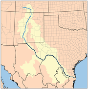
project, begun in 1905, that taps the Rio Grande
Rio Grande
The Rio Grande is a river that flows from southwestern Colorado in the United States to the Gulf of Mexico. Along the way it forms part of the Mexico – United States border. Its length varies as its course changes...
in the states of New Mexico
New Mexico
New Mexico is a state located in the southwest and western regions of the United States. New Mexico is also usually considered one of the Mountain States. With a population density of 16 per square mile, New Mexico is the sixth-most sparsely inhabited U.S...
and Texas, in the United States. 175000 acres (708.2 km²) of irrigated land, in a strip of land along the river no more than 4.5 miles (7.2 km) wide, are covered by the project, while 18000 acres (72.8 km²) are supplied by excess drainage water. Approximately 60 percent of this land is in New Mexico, while the rest is in Texas. Some water is also supplied to Mexico
Mexico
The United Mexican States , commonly known as Mexico , is a federal constitutional republic in North America. It is bordered on the north by the United States; on the south and west by the Pacific Ocean; on the southeast by Guatemala, Belize, and the Caribbean Sea; and on the east by the Gulf of...
, to irrigate some 25,000 more acres. Other than irrigation, a hydroelectric power plant at Elephant Butte Dam
Elephant Butte Dam
Elephant Butte Dam or Elephant Butte Dike is a concrete gravity dam on the Rio Grande near Truth or Consequences, New Mexico. The river was dammed here, impounding the Elephant Butte Reservoir for recreation and agriculture, lessening the downstream flow from a Rio Bravo to a stream a foot deep.The...
supplies electricity to cities in the area.
Diversion dam
A diversion dam is the term for a dam that diverts all or a portion of the flow of a river from its natural course. Diversion dams do not generally impound water in a reservoir...
s, 596 miles (959.2 km) of canal
Canal
Canals are man-made channels for water. There are two types of canal:#Waterways: navigable transportation canals used for carrying ships and boats shipping goods and conveying people, further subdivided into two kinds:...
s and their branches, a hydroelectric generating facility, and over 460 miles (740.3 km) of drainage channels and pipes.
History
Indigenous peoples of the Americas
The indigenous peoples of the Americas are the pre-Columbian inhabitants of North and South America, their descendants and other ethnic groups who are identified with those peoples. Indigenous peoples are known in Canada as Aboriginal peoples, and in the United States as Native Americans...
s, for hundreds or perhaps thousands of years. These native people, most notably Pueblo Indians, used simple irrigation systems that were noted by the Spanish in the 16th century, while conducting expeditions from Mexico
Mexico
The United Mexican States , commonly known as Mexico , is a federal constitutional republic in North America. It is bordered on the north by the United States; on the south and west by the Pacific Ocean; on the southeast by Guatemala, Belize, and the Caribbean Sea; and on the east by the Gulf of...
to North America. In the mid-19th century, irrigation development of the Rio Grande watershed became more intense. A variety of dikes
Levee
A levee, levée, dike , embankment, floodbank or stopbank is an elongated naturally occurring ridge or artificially constructed fill or wall, which regulates water levels...
, dams, canal
Canal
Canals are man-made channels for water. There are two types of canal:#Waterways: navigable transportation canals used for carrying ships and boats shipping goods and conveying people, further subdivided into two kinds:...
s, and other irrigation structures were constructed along the Rio Grande. Every time a flood occurred, the river would take out some of these primitive structures, and a large, coordinated project was needed to build a series of stronger, higher-capacity structures to replace them. However, investigations to begin this project did not begin until over a half-century later.
Colorado River
The Colorado River , is a river in the Southwestern United States and northwestern Mexico, approximately long, draining a part of the arid regions on the western slope of the Rocky Mountains. The watershed of the Colorado River covers in parts of seven U.S. states and two Mexican states...
to the west. This drastic diversion began in the 1890s, when the Rio Grande in Colorado, upstream of New Mexico and Texas, was diverted for the same purposes as the present-day Rio Grande Project. The river's flow near El Paso, Texas
El Paso, Texas
El Paso, is a city in and the county seat of El Paso County, Texas, United States, and lies in far West Texas. In the 2010 census, the city had a population of 649,121. It is the sixth largest city in Texas and the 19th largest city in the United States...
, was reduced to a trickle, sometimes with no flow at all, in the summer months. A dam (currently Elephant Butte Dam
Elephant Butte Dam
Elephant Butte Dam or Elephant Butte Dike is a concrete gravity dam on the Rio Grande near Truth or Consequences, New Mexico. The river was dammed here, impounding the Elephant Butte Reservoir for recreation and agriculture, lessening the downstream flow from a Rio Bravo to a stream a foot deep.The...
, formerly "Engle Dam") was proposed at a site called Elephant Butte to resolve these problems. Following that proposal, the Rio Grande Project was proposed in 1902 after the Newlands Reclamation Act
Newlands Reclamation Act
The Reclamation Act of 1902 is a United States federal law that funded irrigation projects for the arid lands of 20 states in the American West....
, surveyed in 1903, studied for achievability in 1904, and finally incepted in 1905.
Canal
Canals are man-made channels for water. There are two types of canal:#Waterways: navigable transportation canals used for carrying ships and boats shipping goods and conveying people, further subdivided into two kinds:...
, begun in 1906. The dam and canal were finished in 1908. Elephant Butte Dam
Elephant Butte Dam
Elephant Butte Dam or Elephant Butte Dike is a concrete gravity dam on the Rio Grande near Truth or Consequences, New Mexico. The river was dammed here, impounding the Elephant Butte Reservoir for recreation and agriculture, lessening the downstream flow from a Rio Bravo to a stream a foot deep.The...
, the largest dam on the Rio Grande, was the next one to be built. The dam was authorized by the United States Congress
United States Congress
The United States Congress is the bicameral legislature of the federal government of the United States, consisting of the Senate and the House of Representatives. The Congress meets in the United States Capitol in Washington, D.C....
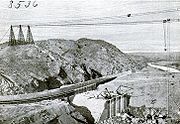
on February 15, 1905. The dam construction began in 1908, when groundworks were laid. Conflicts over reservoir land slowed the project, but the dam was begun again in 1912. Storage operation of the dam preceded completion; this operation began in January 1915 while the dam was only completed in 1916. The Franklin Canal was an existing 1890 canal purchased by the Bureau of Reclamation in 1912; and capacity was added from 1914 to 1915. The Mesilla Diversion Dam, Percha Diversion Dam, East Side Canal, West Side Canal, Rincon Valley Canal, and a Leasburg Canal enlargement were built in the period between 1914 and 1919.
Groundwater
Groundwater is water located beneath the ground surface in soil pore spaces and in the fractures of rock formations. A unit of rock or an unconsolidated deposit is called an aquifer when it can yield a usable quantity of water. The depth at which soil pore spaces or fractures and voids in rock...
, which caused a major leakage of water in the area. As a response, in 1916, the extensive 465 miles (748.3 km) drainage system of the Rio Grande Project was begun, though contracts for the construction of these drainage systems, as well as distribution canals ("laterals") were not awarded until the period from 1917 to 1918. From this period on until 1929, the entire irrigation system was overhauled. This involved repairing, rebuilding and extending old canals; and construction of new laterals. The work is still in progress, as development in the region continues to grow.
The last major components of the project were constructed from the 1930s to the early 1950s. The Caballo Dam was a flood control
Flood control
In communications, flood control is a feature of many communication protocols designed to prevent overwhelming of a destination receiver. Such controls can be implemented either in software or in hardware, and will often request that the message be resent after the receiver has finished...
and storage dam began in 1936. The dam was finished in 1938. The Caballo Dam was built to provide flood protection for the projects downstream, as well as to store power generation waters for dry season irrigation. This added benefit warranted the construction of the Elephant Butte Powerplant upstream. The power plant was constructed from 1938 to 1940. The construction of the power transmission lines leading from the power plant to surrounding areas were begun in 1940, and were finally completed by 1952.
Elephant Butte Dam
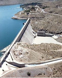
The Elephant Butte Dam (also referred to as Elephant Butte Dike) is the largest dam of the project, built from 1908 to 1915. It is a concrete gravity dam, 25 miles (40.2 km) upstream of the Caballo Dam. The dam is 193 feet (58.8 m) above the river on the downstream side, 301 feet (91.7 m) high from its foundations, and 4414 feet (1,345.4 m) long. At the base, the dam is 228 feet (69.5 m) thick, while at the crest, it tapers to about 18 feet (5.5 m) thick. Notably, there are a series of small spring
Spring (hydrosphere)
A spring—also known as a rising or resurgence—is a component of the hydrosphere. Specifically, it is any natural situation where water flows to the surface of the earth from underground...
s below the dam's foundation.
The volume of concrete used in the dam is some 629,500 cubic yards. The storage capacity of the Elephant Butte Reservoir is 2109423 acre.ft. The outlet works
Outlet works
A set of outlet works is a device used to release and regulate water flow from a dam. Such devices usually consist of one or more pipes or tunnels through the embankment of the dam, directing water usually under high pressure to the river downstream...
of the dam can release 10800 ft3 per second, while the adjacent spillway
Spillway
A spillway is a structure used to provide the controlled release of flows from a dam or levee into a downstream area, typically being the river that was dammed. In the UK they may be known as overflow channels. Spillways release floods so that the water does not overtop and damage or even destroy...
can release 34750 ft3 per second.
The drainage basin of the Rio Grande upstream of the dam is 28900 square miles (74,850.7 km²). The dam's power plant generates 27,945 kilowatts of electricity.
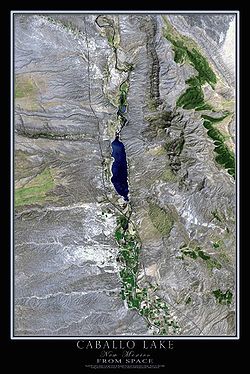
Caballo Dam
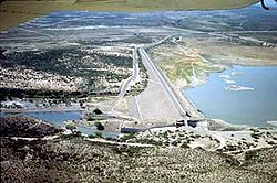
The Caballo Dam is the second major dam of the Rio Grande Project, downstream of the larger Elephant Butte Dam. Built from 1936 to 1948, the dam is 78 feet (23.8 m) high above the riverbed downstream, 96 feet (29.3 m) high from its foundations, and 4558 feet (1,389.3 m) long. It forms the Caballo Reservoir.
The outlet works can release 5000 ft3 cubic feet per second, while the spillway can accommodate 33200 ft3 per second.
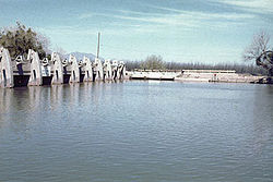
Percha Diversion Dam and Rincon Valley Main Canal
Percha Diversion Dam is a diversion damDiversion dam
A diversion dam is the term for a dam that diverts all or a portion of the flow of a river from its natural course. Diversion dams do not generally impound water in a reservoir...
downstream and 1 miles (1.6 km) west of the Caballo Dam. It is an earthfill design, 19 feet (5.8 m) high above the riverbed, 29 feet (8.8 m) above its foundations, and 2489 feet (758.6 m) long.
The dam's central section is concrete and flanked by earthen wing dikes. The Percha Diversion Dam diverts water into the Rincon Valley Main Canal, which irrigates 16260 acres (25.4 sq mi) of land in the Rincon Valley. The canal is 28.1 miles (45.2 km) long, and carries 350 ft3 per second of water.
Leasburg Diversion Dam and Canal, Pichacho North and South Dams
Weir
A weir is a small overflow dam used to alter the flow characteristics of a river or stream. In most cases weirs take the form of a barrier across the river that causes water to pool behind the structure , but allows water to flow over the top...
about 600 feet (182.9 m) long, and has a capacity of 17000 ft3 per second.
The dam diverts water into the Leasburg Canal, which leads 13.7 miles (22 km) into 31600 acres (127.9 km²) of land in the upper Mesilla Valley. The canal has a capacity of 625 ft3 per second.
Pichacho North and Pichacho South dams impound North Pichacho Arroyo and South Pichacho Arroyo, respectively, to provide flood control for the Leasburg Canal. Both arroyos are ephemeral
Ephemeral
Ephemeral things are transitory, existing only briefly. Typically the term is used to describe objects found in nature, although it can describe a wide range of things....
, and so the dams operate only during storm events. The dams were both built in the 1950s.
- Pichacho North is an earthfill dam 38 feet (11.6 m) high above the streambed, 41 feet (12.5 m) high above foundations, and 1610 feet (490.7 m) long. It has an uncontrolled crest spillway that is 200 feet (61 m) long. North Pichacho Arroyo above the dam has a drainage area of 11 square miles (28.5 km²).
- Pichacho South is a smaller earthfill dam that stands 26 feet (7.9 m) high above the arroyo and 30 feet (9.1 m) from foundation to crest. The dam is 3945 feet (1,202.4 m) long. Its spillway is of similar design to that of North Pichacho, and is 100 feet (30.5 m) long. South Pichacho Arroyo above that dam has a drainage basin of about 6 square miles (15.5 km²).
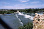
Mesilla Diversion Dam and Canals
American Diversion Dam and Canal, Franklin Canal
The American Diversion Dam is a gated dam between earthfill dikesEmbankment dam
An embankment dam is a massive artificial water barrier. It is typically created by the emplacement and compaction of a complex semi-plastic mound of various compositions of soil, sand, clay and/or rock. It has a semi-permanent waterproof natural covering for its surface, and a dense, waterproof...
on either side, about 2 miles (3.2 km) northwest of El Paso, Texas
El Paso, Texas
El Paso, is a city in and the county seat of El Paso County, Texas, United States, and lies in far West Texas. In the 2010 census, the city had a population of 649,121. It is the sixth largest city in Texas and the 19th largest city in the United States...
, and just upstream from the Mexico – United States border. It is 5 feet (1.5 m) high above the riverbed, and 18 feet (5.5 m) from crest to foundation. The dam spills water over a broad-crested weir in the center that is 286 feet (87.2 m) long. Its spillway can carry 12000 ft3 of water per second during flood events. The dam diverts 1200 ft3 per second of the river's flow into the American Canal, which carries water 2.1 miles (3.4 km) to the beginning of the Franklin Canal. The Franklin Canal is 28.4 miles (45.7 km) long, carrying water into the El Paso Valley. The water it carries irrigates about 17000 acres (68.8 km²) of land.
Riverside Diversion Dam and Canal, Tornillo Canal
Riverside Diversion Dam is the final diversion dam on the Rio Grande for the Rio Grande Project. The dam is 8 feet (2.4 m) above the streambed, 17.5 feet (5.3 m) above its foundations, and 267 feet (81.4 m) long. Its spillway consists of 6 radial gates 16 feet (4.9 m) by 8.17 feet (2.5 m) in size, and an uncontrolled overflow weir serves as an emergency spillway. The Riverside Canal carries water 17.2 miles (27.7 km) to the El Paso Valley. It has a capacity of 900 ft3 per second. The Tornillo Canal branches 12 miles (19.3 km) off the Riverside Canal, carrying about 325 ft3 per second. Excess waters from the canals are diverted to the Hudspeth County area.Positive impacts
Pecan
The pecan , Carya illinoinensis, is a species of hickory, native to south-central North America, in Mexico from Coahuila south to Jalisco and Veracruz, in the United States from southern Iowa, Illinois, Missouri, and Indiana east to western Kentucky, southwestern Ohio, North Carolina, South...
s, alfalfa
Alfalfa
Alfalfa is a flowering plant in the pea family Fabaceae cultivated as an important forage crop in the US, Canada, Argentina, France, Australia, the Middle East, South Africa, and many other countries. It is known as lucerne in the UK, France, Australia, South Africa and New Zealand, and known as...
, cotton, and many types of vegetables. The project also includes a solitary hydroelectric power plant
Hydroelectricity
Hydroelectricity is the term referring to electricity generated by hydropower; the production of electrical power through the use of the gravitational force of falling or flowing water. It is the most widely used form of renewable energy...
, the 27,945-kilowatt Elephant Butte Powerplant. Power generated at the power plant is distributed through an electrical grid totaling 490 miles (788.6 km) of 115-kilovolt
Volt
The volt is the SI derived unit for electric potential, electric potential difference, and electromotive force. The volt is named in honor of the Italian physicist Alessandro Volta , who invented the voltaic pile, possibly the first chemical battery.- Definition :A single volt is defined as the...
transmission lines
Electric power transmission
Electric-power transmission is the bulk transfer of electrical energy, from generating power plants to Electrical substations located near demand centers...
and 11 substations
Electrical substation
A substation is a part of an electrical generation, transmission, and distribution system. Substations transform voltage from high to low, or the reverse, or perform any of several other important functions...
. This power system was built by the Rio Grande Project, and remained under its ownership until 1977, when it was sold to a private company.
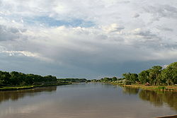
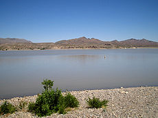
The two main reservoirs formed by the Rio Grande Project are Caballo and Elephant Butte reservoirs, both of which are popular targets for recreational activities. Elephant Butte Reservoir, with an area of 36897 acres (149.3 km²), is popular for swimming, boating, and fishing. Cabins, fishing tackle, and boat rental services are available at the reservoir. Downstream Caballo Reservoir, with an area of 11500 acres (46.5 km²), is also a popular site for picnicking, fishing and boating.
Negative impacts
Colorado
Colorado is a U.S. state that encompasses much of the Rocky Mountains as well as the northeastern portion of the Colorado Plateau and the western edge of the Great Plains...
alone. In 1896, it was affirmed by the United States Geological Survey
United States Geological Survey
The United States Geological Survey is a scientific agency of the United States government. The scientists of the USGS study the landscape of the United States, its natural resources, and the natural hazards that threaten it. The organization has four major science disciplines, concerning biology,...
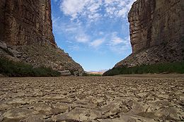
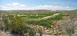
(USGS) that the river's flow was decreasing by 200000 acre.ft annually. The river has run dry several times since the 1950s, even as far upstream as Big Bend National Park
Big Bend National Park
Big Bend National Park is a national park located in the U.S. state of Texas. Big Bend has national significance as the largest protected area of Chihuahuan Desert topography and ecology in the United States, which includes more than 1,200 species of plants, more than 450 species of birds, 56...
. At El Paso, Texas
El Paso, Texas
El Paso, is a city in and the county seat of El Paso County, Texas, United States, and lies in far West Texas. In the 2010 census, the city had a population of 649,121. It is the sixth largest city in Texas and the 19th largest city in the United States...
, the river is non-existent for much of the year. Tributaries of the river, both on the Mexican and American sides, have been diverted heavily for irrigation. The Rio Grande is said to be "one of the most stressed river basins in the world". In 2001, the river failed to reach the Gulf of Mexico
Gulf of Mexico
The Gulf of Mexico is a partially landlocked ocean basin largely surrounded by the North American continent and the island of Cuba. It is bounded on the northeast, north and northwest by the Gulf Coast of the United States, on the southwest and south by Mexico, and on the southeast by Cuba. In...
but instead ended 500 feet (152.4 m) from the shore behind a sandbar
Shoal
Shoal, shoals or shoaling may mean:* Shoal, a sandbank or reef creating shallow water, especially where it forms a hazard to shipping* Shoal draught , of a boat with shallow draught which can pass over some shoals: see Draft...
, "not with a roar but with a whimper in the sand".
Illegal immigration to the United States
An illegal immigrant in the United States is an alien who has entered the United States without government permission or stayed beyond the termination date of a visa....
once had to swim across the river at the border. With the river so low, at several places immigrants need only to walk across. Other than the extensive diversions, scientists are also naming exotic introduced, fast-growing plants, such as water hyacinth
Eichhornia crassipes
Eichhornia crassipes, commonly known as Common Water Hyacinth, is an aquatic plant native to the Amazon basin, and is often considered a highly problematic invasive species outside its native range.-Ecology:...
and hydrilla
Hydrilla
Hydrilla is an aquatic plant genus, usually treated as containing just one species, Hydrilla verticillata, though some botanists divide it into several species. Synonyms include H. asiatica, H. japonica, H. lithuanica, and H. ovalifolica...
, as the culprit of the reduced flows. The weeds feed on the remaining water in the river and encroach rapidly, sucking water out of the Rio Grande. The United States government has recently attempted to slow or stop the progress of these weeds by introducing
Biological pest control
Biological control of pests in agriculture is a method of controlling pests that relies on predation, parasitism, herbivory, or other natural mechanisms...
insects and fish that feed on the invasive plants.