
Ridgeley, West Virginia
Encyclopedia
Ridgeley is a town in Mineral County
, West Virginia
, United States
, and part of the Cumberland Metropolitan Statistical Area. The population was 762 at the 2000 census but has fallen to 575 with the 2010 census.
Ridgeley was initially known as St. Clairsville, Named for Sir John St Clair, Lt Colonel and Quartermaster General for British General Edward Braddock
. St Clair accompanied Braddock on his ill-fated march on Fort Duquesne
and his disastrous defeat on July 9, 1755. It was incorporated
as Ridgeley on November 28, 1914, named for the former owners of the land upon which the town was built.
.
According to the United States Census Bureau
, the town has a total area of 0.3 square miles (0.8 km²), of which 0.3 square mile (0.7 km²) is land and 0.04 square mile (0.1 km²) (6.90%) is water.
of the Old Port Formation
is located in the town. The Ridgeley is primarily a sandstone
, and is quarried locally. The rock is often called "Oriskany Sandstone" in West Virginia and Maryland, but that name is no longer applied to this mid-Appalachian
formation.
of 2010, there were 675 people, 323 households, and 202 families residing in the town. The population density
was 2,809.5 inhabitants per square mile (1,089.7/km²). There were 379 housing units at an average density of 1,397.4 per square mile (542.0/km²). The racial makeup of the town was 99.08% White, 0.52% African American, 0.13% Native American, and 0.26% from two or more races. Hispanic or Latino of any race were 2.49% of the population.
There were 323 households out of which 29.7% had children under the age of 18 living with them, 44.0% were married couples
living together, 15.5% had a female householder with no husband present, and 37.2% were non-families. 34.1% of all households were made up of individuals and 18.9% had someone living alone who was 65 years of age or older. The average household size was 2.36 and the average family size was 3.03.
In the town the population was spread out with 26.9% under the age of 18, 7.7% from 18 to 24, 25.3% from 25 to 44, 21.4% from 45 to 64, and 18.6% who were 65 years of age or older. The median age was 36 years. For every 100 females there were 87.2 males. For every 100 females age 18 and over, there were 87.5 males.
The median income for a household in the town was $26,016, and the median income for a family was $36,042. Males had a median income of $29,250 versus $20,227 for females. The per capita income
for the town was $14,199. About 13.3% of families and 16.3% of the population were below the poverty line, including 18.0% of those under age 18 and 17.7% of those age 65 or over.
is located near Short Gap, West Virginia
and contains the grades 9-12. Keyser High School
, located in Keyser, West Virginia
, about 21 miles away from Ridgeley, is also in the Mineral County School District.
to George Mason
in 1749. In 1750, the first frontier fort, Fort Ohio
, was built at Ridgeley. It was, at the time, the westernmost outpost of colonial civilization and was most commonly referred to as the "New Store" settlement at the time. The New Store was primarily a trading post created by the Ohio Company
which included prominent members including George Mason and Lawrence Washington. There is evidence that Joseph Chapline, the founder of Sharpsburg, Maryland
, who also was in charge of the construction of Fort Cumberland
, organized the construction of the New Store settlement . The settlement was used for various purposes from 1750-1763. Early Ohio Company residents who worked at the settlement (and who explored the surrounding countryside) included Hugh Parker and Christopher Gist.
In May 1754, George Washington
led a company of troops to meet Joshua Fry
at the storehouses at Fort Ohio. Fry was a colonel and commander in the Virginia Militia
. He was to take command of the forces sent to the frontier. Fry was thrown from his horse, died, and was probably buried in early Ridgeley , as Fort Cumberland had not yet been built. Washington then took command of the troops, his first military command. Washington staged an attack from Fort Ohio against a French
detachment of 40 men that resulted in the death of French diplomat Ensign Joseph Coulon de Jumonville
. This action is considered the first shot fired in the French and Indian War
.
In Spring 1755, Washington returned to the area to prepare for General Edward Braddock
's attack on Fort Duquesne
(commonly referred to as Braddock's March). Fort Cumberland was under construction at the time, and was used as the center of planning for the attack, while Fort Ohio was commandeered and used as well. Both a young Daniel Boone
(age 21) and Daniel Morgan
(age 20) worked in the area to plan and carry out the ill-fated assault.
When Fort Cumberland was all but abandoned in 1763, the Ohio Company reclaimed the land and put it up for sale. Eventually, the land was conveyed to James McCubbin Lingan
in 1785, then to Captain George Calmes in 1803. Calmes built a mansion on the property. The land and home passed down through George Calmes' family through most of the 1800s. Late in that century, portions of the town began to be subdivided for housing and business use. In 1905, a group leased the Calmes Mansion and created the Potomac Club, which operated in Ridgeley as an important tennis and boating club until 1919.
In 1887, the West Virginia Central and Pittsburg Railway
built yards
and tracks in Ridgeley. In 1904, the West Virginia Central became the Western Maryland Railroad. The town developed as a blue collar
community, many of whose residents worked for the railroad. For most of its history, it had been called alternately "St. Clairsville" or "Sinclairsville," but upon incorporation in 1914, it was renamed Ridgeley after Charles Ridgeley (1822–1897) a prominent early resident and businessman.
The town grew throughout the early part of the 20th century to be a vibrant blue-collar community of schools, churches and businesses. Serious flood
ing from the Potomac River
was a challenge to the town until the Army Corps of Engineers completed a major flood control
project in the 1950s. During the 1970s and 1980s, as the Mineral County school system consolidated schools in the area, all the town's schools were closed, challenging Ridgeley's cohesiveness as a community.7
In recent years, Ridgeley has been plagued by a series of difficulties that have raised questions on the town's overall quality of life. As of 2008, the town has no grocery stores or banks (though it does have a convenience store). It does, however, have 16 active alcoholic beverage licenses, an average of one for every 47.6 residents.
In 2007, Ridgeley hit the news when the town's mayor, Mitchell Reeves, was indicted on a number of charges and was able to call from jail and fire the Police Chief and police clerk, who had participated in the investigation. Both were found to be fired without cause and were rehired when a new mayor and council took office. The town's police chief, Michael Miller, has since been fired again, and was rehired again after a citizen's action committee insisted that Miller was only following the directions of the police commissioner as he carried out his duties. In West Virginia, the Police Commissioner in towns of this size is the mayor.
The number of weekend incidents in Ridgeley has continued to rise despite a higher-than-state-average police force for its population. The West Virginia average is 1.92 officers per 1,000 residents. The current ratio of officers to residents in Ridgeley is 4.44. 9 Despite this high number of officers, the crime rate has continued to rise. On September 4, 2011 a physical altercation at the "My Place" bar in downtown Ridgeley spilled over into the community, resulting in the deaths of two out-of-town visitors. The incident was investigated by the Ridgeley Police, the Mineral County Police, Cumberland City Police
, and the C3I unit from Allegany County, Maryland
, all working in collaboration .
Finance - Thomas Hedrick
Parks/Rec - Mark Jones
Water/Sewer - Robert Shipley
Housing/Ordinances - Lynn Carr
Streets/Sidewalks - Don McFarland
Mineral County, West Virginia
Mineral County is a county located in the U.S. state of West Virginia. It is part of the Cumberland, MD-WV Metropolitan Statistical Area. As of 2010, the population was 28,212. Its county seat is Keyser.-Ancient history:...
, West Virginia
West Virginia
West Virginia is a state in the Appalachian and Southeastern regions of the United States, bordered by Virginia to the southeast, Kentucky to the southwest, Ohio to the northwest, Pennsylvania to the northeast and Maryland to the east...
, United States
United States
The United States of America is a federal constitutional republic comprising fifty states and a federal district...
, and part of the Cumberland Metropolitan Statistical Area. The population was 762 at the 2000 census but has fallen to 575 with the 2010 census.
Ridgeley was initially known as St. Clairsville, Named for Sir John St Clair, Lt Colonel and Quartermaster General for British General Edward Braddock
Edward Braddock
General Edward Braddock was a British soldier and commander-in-chief for the 13 colonies during the actions at the start of the French and Indian War...
. St Clair accompanied Braddock on his ill-fated march on Fort Duquesne
Fort Duquesne
Fort Duquesne was a fort established by the French in 1754, at the junction of the Allegheny and Monongahela rivers in what is now downtown Pittsburgh in the state of Pennsylvania....
and his disastrous defeat on July 9, 1755. It was incorporated
Municipal corporation
A municipal corporation is the legal term for a local governing body, including cities, counties, towns, townships, charter townships, villages, and boroughs. Municipal incorporation occurs when such municipalities become self-governing entities under the laws of the state or province in which...
as Ridgeley on November 28, 1914, named for the former owners of the land upon which the town was built.
Geography
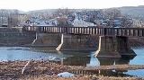
Ridgeley is located at 39°38′35"N 78°46′9"W (39.643187, -78.769189), along the North Branch of the Potomac River, opposite Cumberland, MarylandCumberland, Maryland
Cumberland is a city in the far western, Appalachian portion of Maryland, United States. It is the county seat of Allegany County, and the primary city of the Cumberland, MD-WV Metropolitan Statistical Area. At the 2010 census, the city had a population of 20,859, and the metropolitan area had a...
.
According to the United States Census Bureau
United States Census Bureau
The United States Census Bureau is the government agency that is responsible for the United States Census. It also gathers other national demographic and economic data...
, the town has a total area of 0.3 square miles (0.8 km²), of which 0.3 square mile (0.7 km²) is land and 0.04 square mile (0.1 km²) (6.90%) is water.
Geology
The type locality of the Ridgeley MemberRidgeley sandstone
The Ridgeley sandstone is a sandstone or quartzite of Devonian age found in the Appalachian Mountains of Pennsylvania, Maryland, West Virginia, and Virginia, USA. The Ridgeley is fine-grained, siliceous, calcareous in its lower strata, sometimes fossiliferous, and sometimes locally pebbly or...
of the Old Port Formation
Old Port Formation
The Devonian Old Port Formation is a mapped bedrock unit in Pennsylvania, Maryland, and West Virginia. Members of the unit are also mapped in New Jersey and Virginia as parts of other formations or groups.-Description:...
is located in the town. The Ridgeley is primarily a sandstone
Sandstone
Sandstone is a sedimentary rock composed mainly of sand-sized minerals or rock grains.Most sandstone is composed of quartz and/or feldspar because these are the most common minerals in the Earth's crust. Like sand, sandstone may be any colour, but the most common colours are tan, brown, yellow,...
, and is quarried locally. The rock is often called "Oriskany Sandstone" in West Virginia and Maryland, but that name is no longer applied to this mid-Appalachian
Appalachian Mountains
The Appalachian Mountains #Whether the stressed vowel is or ,#Whether the "ch" is pronounced as a fricative or an affricate , and#Whether the final vowel is the monophthong or the diphthong .), often called the Appalachians, are a system of mountains in eastern North America. The Appalachians...
formation.
Demographics
As of the censusCensus
A census is the procedure of systematically acquiring and recording information about the members of a given population. It is a regularly occurring and official count of a particular population. The term is used mostly in connection with national population and housing censuses; other common...
of 2010, there were 675 people, 323 households, and 202 families residing in the town. The population density
Population density
Population density is a measurement of population per unit area or unit volume. It is frequently applied to living organisms, and particularly to humans...
was 2,809.5 inhabitants per square mile (1,089.7/km²). There were 379 housing units at an average density of 1,397.4 per square mile (542.0/km²). The racial makeup of the town was 99.08% White, 0.52% African American, 0.13% Native American, and 0.26% from two or more races. Hispanic or Latino of any race were 2.49% of the population.
There were 323 households out of which 29.7% had children under the age of 18 living with them, 44.0% were married couples
Marriage
Marriage is a social union or legal contract between people that creates kinship. It is an institution in which interpersonal relationships, usually intimate and sexual, are acknowledged in a variety of ways, depending on the culture or subculture in which it is found...
living together, 15.5% had a female householder with no husband present, and 37.2% were non-families. 34.1% of all households were made up of individuals and 18.9% had someone living alone who was 65 years of age or older. The average household size was 2.36 and the average family size was 3.03.
In the town the population was spread out with 26.9% under the age of 18, 7.7% from 18 to 24, 25.3% from 25 to 44, 21.4% from 45 to 64, and 18.6% who were 65 years of age or older. The median age was 36 years. For every 100 females there were 87.2 males. For every 100 females age 18 and over, there were 87.5 males.
The median income for a household in the town was $26,016, and the median income for a family was $36,042. Males had a median income of $29,250 versus $20,227 for females. The per capita income
Per capita income
Per capita income or income per person is a measure of mean income within an economic aggregate, such as a country or city. It is calculated by taking a measure of all sources of income in the aggregate and dividing it by the total population...
for the town was $14,199. About 13.3% of families and 16.3% of the population were below the poverty line, including 18.0% of those under age 18 and 17.7% of those age 65 or over.
Education
Ridgeley is within the Mineral County School District. Frankfort High SchoolFrankfort High School (West Virginia)
Frankfort High School is a high school in Short Gap, West Virginia that houses over 600 students from Ridgeley, Short Gap, Ft. Ashby, Wiley Ford, and Carpendale...
is located near Short Gap, West Virginia
Short Gap, West Virginia
Short Gap is an unincorporated community in Mineral County, West Virginia located at the intersection of West Virginia Route 956 and West Virginia Route 28. The community is home to Frankfort High School, as well as Frankfort Middle School, which serve the northern part of Mineral County including...
and contains the grades 9-12. Keyser High School
Keyser High School
Keyser High School is a high school located south of Keyser, West Virginia with an enrollment of more than 800 students from southern Mineral County, WV. The school's fight song is sung to the tune of Anchors Aweigh.-History:...
, located in Keyser, West Virginia
Keyser, West Virginia
Keyser is a city in and the county seat of Mineral County, West Virginia, United States. It is part of the Cumberland, MD-WV Metropolitan Statistical Area. The population was 5,303 at the 2000 census.- History :...
, about 21 miles away from Ridgeley, is also in the Mineral County School District.
History
The land on which the town is built was originally conveyed from Thomas Lord FairfaxThomas Fairfax, 6th Lord Fairfax of Cameron
Thomas Fairfax, 6th Lord Fairfax of Cameron was the son of Thomas Fairfax, 5th Lord Fairfax of Cameron and of Catherine, daughter of Thomas Culpeper, 2nd Baron Culpeper of Thoresway....
to George Mason
George Mason
George Mason IV was an American Patriot, statesman and a delegate from Virginia to the U.S. Constitutional Convention...
in 1749. In 1750, the first frontier fort, Fort Ohio
Fort Ohio
Fort Ohio Fort Ohio Fort Ohio (also known as the "New Store" was a stockade fort erected by Job Pearsall in 1749 on the present site of Ridgeley, West Virginia. The building was of log construction, long and wide, with two stories...
, was built at Ridgeley. It was, at the time, the westernmost outpost of colonial civilization and was most commonly referred to as the "New Store" settlement at the time. The New Store was primarily a trading post created by the Ohio Company
Ohio Company
The Ohio Company, formally known as the Ohio Company of Virginia, was a land speculation company organized for the settlement by Virginians of the Ohio Country and to trade with the Indians there...
which included prominent members including George Mason and Lawrence Washington. There is evidence that Joseph Chapline, the founder of Sharpsburg, Maryland
Sharpsburg, Maryland
Sharpsburg is a town in Washington County, Maryland, United States, approximately south of Hagerstown. The population was 691 at the 2000 census....
, who also was in charge of the construction of Fort Cumberland
Fort Cumberland (Maryland)
thumb|380px|Fort Cumberland, 1755 Fort Cumberland was an 18th century frontier fort at the current site of Cumberland, Maryland, USA...
, organized the construction of the New Store settlement . The settlement was used for various purposes from 1750-1763. Early Ohio Company residents who worked at the settlement (and who explored the surrounding countryside) included Hugh Parker and Christopher Gist.
In May 1754, George Washington
George Washington
George Washington was the dominant military and political leader of the new United States of America from 1775 to 1799. He led the American victory over Great Britain in the American Revolutionary War as commander-in-chief of the Continental Army from 1775 to 1783, and presided over the writing of...
led a company of troops to meet Joshua Fry
Joshua Fry
Colonel Joshua Fry was a surveyor, adventurer, mapmaker, soldier, and member of the House of Burgesses, the legislature of the colony of Virginia...
at the storehouses at Fort Ohio. Fry was a colonel and commander in the Virginia Militia
Virginia Militia
The Virginia militia is an armed force composed of all citizens of the Commonwealth of Virginia capable of bearing arms. The Virginia militia was established in 1607 as part of the British militia system. Militia service in Virginia was compulsory for all free males...
. He was to take command of the forces sent to the frontier. Fry was thrown from his horse, died, and was probably buried in early Ridgeley , as Fort Cumberland had not yet been built. Washington then took command of the troops, his first military command. Washington staged an attack from Fort Ohio against a French
France
The French Republic , The French Republic , The French Republic , (commonly known as France , is a unitary semi-presidential republic in Western Europe with several overseas territories and islands located on other continents and in the Indian, Pacific, and Atlantic oceans. Metropolitan France...
detachment of 40 men that resulted in the death of French diplomat Ensign Joseph Coulon de Jumonville
Joseph Coulon de Jumonville
Joseph Coulon de Villiers, Sieur de Jumonville was a French Canadian military officer. His defeat and killing at the Battle of Jumonville Glen by forces led by George Washington was one of the sparks igniting the Seven Years' War.- Early life :Jumonville was born in the seigneury of Verchères, New...
. This action is considered the first shot fired in the French and Indian War
French and Indian War
The French and Indian War is the common American name for the war between Great Britain and France in North America from 1754 to 1763. In 1756, the war erupted into the world-wide conflict known as the Seven Years' War and thus came to be regarded as the North American theater of that war...
.
In Spring 1755, Washington returned to the area to prepare for General Edward Braddock
Edward Braddock
General Edward Braddock was a British soldier and commander-in-chief for the 13 colonies during the actions at the start of the French and Indian War...
's attack on Fort Duquesne
Fort Duquesne
Fort Duquesne was a fort established by the French in 1754, at the junction of the Allegheny and Monongahela rivers in what is now downtown Pittsburgh in the state of Pennsylvania....
(commonly referred to as Braddock's March). Fort Cumberland was under construction at the time, and was used as the center of planning for the attack, while Fort Ohio was commandeered and used as well. Both a young Daniel Boone
Daniel Boone
Daniel Boone was an American pioneer, explorer, and frontiersman whose frontier exploits mad']'e him one of the first folk heroes of the United States. Boone is most famous for his exploration and settlement of what is now the Commonwealth of Kentucky, which was then beyond the western borders of...
(age 21) and Daniel Morgan
Daniel Morgan
Daniel Morgan was an American pioneer, soldier, and United States Representative from Virginia. One of the most gifted battlefield tacticians of the American Revolutionary War, he later commanded troops during the suppression of the Whiskey Rebellion.-Early years:Most authorities believe that...
(age 20) worked in the area to plan and carry out the ill-fated assault.
When Fort Cumberland was all but abandoned in 1763, the Ohio Company reclaimed the land and put it up for sale. Eventually, the land was conveyed to James McCubbin Lingan
James Lingan
-External links:*-Baltimore Riot of 1812:**...
in 1785, then to Captain George Calmes in 1803. Calmes built a mansion on the property. The land and home passed down through George Calmes' family through most of the 1800s. Late in that century, portions of the town began to be subdivided for housing and business use. In 1905, a group leased the Calmes Mansion and created the Potomac Club, which operated in Ridgeley as an important tennis and boating club until 1919.
In 1887, the West Virginia Central and Pittsburg Railway
West Virginia Central and Pittsburg Railway
The West Virginia Central and Pittsburg Railway was a railroad in West Virginia and Maryland operating in the late 19th and early 20th centuries. It had main lines radiating from Elkins, West Virginia in four principal directions: north to Cumberland, Maryland; west to Belington, WV; south to...
built yards
Rail yard
A rail yard, or railroad yard, is a complex series of railroad tracks for storing, sorting, or loading/unloading, railroad cars and/or locomotives. Railroad yards have many tracks in parallel for keeping rolling stock stored off the mainline, so that they do not obstruct the flow of traffic....
and tracks in Ridgeley. In 1904, the West Virginia Central became the Western Maryland Railroad. The town developed as a blue collar
Blue collar
Blue collar can refer to:*Blue-collar worker, a traditional designation of the working class*Blue-collar crime, the types of crimes typically associated with the working class*A census designation...
community, many of whose residents worked for the railroad. For most of its history, it had been called alternately "St. Clairsville" or "Sinclairsville," but upon incorporation in 1914, it was renamed Ridgeley after Charles Ridgeley (1822–1897) a prominent early resident and businessman.
The town grew throughout the early part of the 20th century to be a vibrant blue-collar community of schools, churches and businesses. Serious flood
Flood
A flood is an overflow of an expanse of water that submerges land. The EU Floods directive defines a flood as a temporary covering by water of land not normally covered by water...
ing from the Potomac River
Potomac River
The Potomac River flows into the Chesapeake Bay, located along the mid-Atlantic coast of the United States. The river is approximately long, with a drainage area of about 14,700 square miles...
was a challenge to the town until the Army Corps of Engineers completed a major flood control
Flood control
In communications, flood control is a feature of many communication protocols designed to prevent overwhelming of a destination receiver. Such controls can be implemented either in software or in hardware, and will often request that the message be resent after the receiver has finished...
project in the 1950s. During the 1970s and 1980s, as the Mineral County school system consolidated schools in the area, all the town's schools were closed, challenging Ridgeley's cohesiveness as a community.7
In recent years, Ridgeley has been plagued by a series of difficulties that have raised questions on the town's overall quality of life. As of 2008, the town has no grocery stores or banks (though it does have a convenience store). It does, however, have 16 active alcoholic beverage licenses, an average of one for every 47.6 residents.
In 2007, Ridgeley hit the news when the town's mayor, Mitchell Reeves, was indicted on a number of charges and was able to call from jail and fire the Police Chief and police clerk, who had participated in the investigation. Both were found to be fired without cause and were rehired when a new mayor and council took office. The town's police chief, Michael Miller, has since been fired again, and was rehired again after a citizen's action committee insisted that Miller was only following the directions of the police commissioner as he carried out his duties. In West Virginia, the Police Commissioner in towns of this size is the mayor.
The number of weekend incidents in Ridgeley has continued to rise despite a higher-than-state-average police force for its population. The West Virginia average is 1.92 officers per 1,000 residents. The current ratio of officers to residents in Ridgeley is 4.44. 9 Despite this high number of officers, the crime rate has continued to rise. On September 4, 2011 a physical altercation at the "My Place" bar in downtown Ridgeley spilled over into the community, resulting in the deaths of two out-of-town visitors. The incident was investigated by the Ridgeley Police, the Mineral County Police, Cumberland City Police
Cumberland, Maryland
Cumberland is a city in the far western, Appalachian portion of Maryland, United States. It is the county seat of Allegany County, and the primary city of the Cumberland, MD-WV Metropolitan Statistical Area. At the 2010 census, the city had a population of 20,859, and the metropolitan area had a...
, and the C3I unit from Allegany County, Maryland
Allegany County, Maryland
Allegany County is a county located in the northwestern part of the US state of Maryland. It is part of the Cumberland, MD-WV Metropolitan Statistical Area. As of 2010, the population was 75,087. Its county seat is Cumberland...
, all working in collaboration .
Current Mayor and Town Council
Mayor - James TwiggFinance - Thomas Hedrick
Parks/Rec - Mark Jones
Water/Sewer - Robert Shipley
Housing/Ordinances - Lynn Carr
Streets/Sidewalks - Don McFarland
Sources
- Clites, Gary, Ridgeley and Carpendale, West Virginia From 1750: A History, Knobley Mountain Press, ISBN 978-1-4357-2044-2, 2008