

Rhode Island Route 403
Encyclopedia
Route 403, also known as the Quonset Freeway, is a numbered state highway
located in Washington County
and Kent County, Rhode Island
, United States
. The route is a nominally east–west limited-access
freeway for its entire length. A spur
of Rhode Island Route 4, Route 403 serves Davisville
and the Quonset Business Park, providing freeway access to Interstate 95
and the northern Providence metropolitan area
from the industrial zone. The western terminus of the freeway is at a trumpet interchange with Route 4 in East Greenwich
. The route has three unnumbered interchanges along its 4.5 miles (7.2 km) length, including a junction with U.S. Route 1 in North Kingstown
, before terminating at an at-grade intersection
with Roger Williams Way and Commerce Park Road in Quonset
. Route 403 is the highest numbered route
in Rhode Island.
Prior to 2006, Route 403 was a narrow, two-lane road through Davisville. The western terminus of the route was at an interchange with Route 4 and Rhode Island Route 402 in East Greenwich, and the eastern terminus was at U.S. Route 1 in North Kingstown. In order to accommodate increasingly heavy commercial and commuter traffic to and from the Quonset Business Park, the Rhode Island Department of Transportation
constructed the Quonset Freeway as an upgraded Route 403. The relocation of the route began in 2000 and was constructed in two phases; Phase 1, a freeway from Quonset to Davisville, opened in June 2006. Phase 2 of the relocation project, which connected the freeway with Route 4, was completed one year ahead of schedule in December 2008.
 Prior to 2006, Route 403 was a narrow, two-lane road running for 2.4 miles (3.9 km) through Davisville, Rhode Island
. The road, a spur route
of Route 4, connected to Rhode Island Route 402 and Route 4 at its western terminus, and was accessible only from Route 4 southbound. Its eastern terminus was at a grade-separated interchange with U.S. 1
. The nominally east–west route followed a northwestern–southeastern route for most of its length. Route 403 was signed on two local roads, Davisville Road and Devil's Foot Road, in the towns of East Greenwich
and North Kingstown
.
Route 403's original western terminus was at a complex interchange with Routes 4 and 402 in East Greenwich. Both Routes 402 and 403 were accessible from Exit 7 on Route 4 southbound; there was no access to either route from the northbound lanes of Route 4. After the Exit 7 ramp, Route 403 eastbound crossed over Route 4 and began to head in southeastern direction along Davisville Road. Shortly after its western terminus, Route 403 crossed the Hunt River
into Washington County
and Davisville
, a village in the town of North Kingstown. After intersecting Old Baptist Road, a local route that connects to Route 102, Route 403 began to follow Devil's Foot Road, continuing on its southeastern trajectory. The route crossed Amtrak
's Northeast Corridor
rail line before turning to head in an almost due east direction, entering the Quonset Business Park. Shortly after passing Devil's Foot Rock, a petrosomatoglyph
attributed to the Devil
in colonial times, Route 403 passed under U.S. Route 1
(Post Road) and intersected two US 1 access ramps, Davisville Road, and Quonset Road; the latter two roads headed into the business park toward Quonset State Airport
and the Quonset container port. Although the mainline of the road continued eastbound as Quonset Road (now Roger Williams Way), Route 403 officially terminated at the intersection with the US 1 access ramps.
Since the completion of the Quonset Freeway in 2008 and the full relocation of Route 403, the old route on Davisville Road and Devil's Foot Road has been unnumbered. Some portions of the road are signed "To RI 403," but there is no indication that RIDOT plans to designate the old route as Rhode Island Route 403A. Route 403's previous alignment was largely unchanged during the construction of the Quonset Freeway; only the interchanges with Routes 4 and 402 in East Greenwich and with US 1 in North Kingstown were altered significantly.
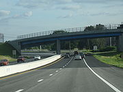
 The Quonset Freeway begins in East Greenwich at Exit 7 of Route 4; southbound, the exit is numbered 7B, as Exit 7A serves Route 402. Unlike Route 402, which is accessible only via Route 4 southbound, Route 403 is accessible from the northbound lanes of Route 4 via the newly constructed Exit 7. Like the original Route 403, the nominally east–west freeway follows a northeastern–southwestern route for much of its length. Shortly after beginning at Route 4, Route 403 crosses over Route 402 and the Hunt River
on a single-span bridge, entering the town of North Kingstown. The relocation of Route 403 removed access to Route 402; the freeway now travels over Frenchtown Road without an interchange. While there is no direct link between the two routes, motorists traveling westbound on Route 403 can take the exit for Route 4 south and then access Route 402 from Exit 7A off Route 4.
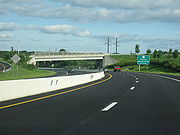
Route 403 continues in a southeastern direction before crossing over Amtrak's Northeast Corridor rail line. The freeway begins to closely parallel the railroad before crossing under Devil's Foot Road, the original Route 403, and entering the village of Davisville. Shortly after the overpass, Route 403 turns to head almost due east. The freeway has its first interchange with West Davisville Road; the exit is accessible only from eastbound Route 403, and serves the villages of Davisville
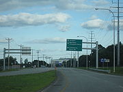
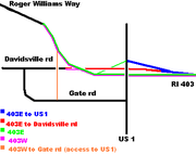
and Quidnessett. Closely paralleling Devil's Foot Road, Route 403 continues eastward before interchanging with U.S. Route 1 (Post Road) and Davisville Road; the two roads are served via a single exit. Westbound Route 403 has no direct interchange with either US 1 or Davisville Road; the route's first westbound exit in Quonset is signed as "To US 1," and connects to Post Road via Gate Road, a commercial outlet in Quonset.
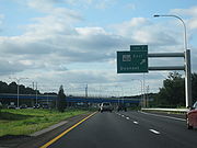
Shortly after the interchange with US 1, Route 403 begins to head in a southwestern direction. After 4.5 miles (7.2 km) miles, Route 403 terminates at a traffic signal with Commerce Park Road, a commercial route that heads north into the business park. The mainline of Route 403 continues eastward as Roger Williams Way (formerly Quonset Road), a four-lane, undivided road that leads to Quonset State Airport
.
 The original Route 403 that existed prior to 2006 was numbered in 1973 as a spur route
of the newly constructed Route 4. The two-lane, undivided state highway was the main access road to Davisville and Quonset Point from Route 4. Quonset was home to Naval Air Station Quonset Point
, a major U.S. naval base, until 1974. After the closure of the base, the Quonset Point region of North Kingstown was converted into an industrial zone and commercial district by the state of Rhode Island; a container port and the Quonset State Airport
were also opened for commercial use.
By the 1980s, more than 12,000 cars were using Route 403 daily to access the business park; the Rhode Island Department of Transportation
(RIDOT) estimated that this vehicle volume would exceed 25,000 by 2005. This high vehicle capacity would be dangerous because of Route 403's sharp curves and low speed limit in Davisville. The narrow route through a densely populated region was particularly unsuitable for the high volume of commercial trucks that used it to access Route 4 from the Quonset Business Park and container port. RIDOT began studies on improving the route in 1987, exploring both the widening of the existing route to a four-lane, undivided highway and the construction of a freeway as options. The proposal to widen the existing road was ultimately dropped, as it would less effective at relieving congestion in the region and would require significant demolition of existing structures in Davisville. A freeway alternative to be constructed north of the existing route with more direct access to Route 4 and an eastward expansion beyond US 1 into the Quonset Business Park was selected instead.
 Construction of "Phase 1" of the four-lane, limited-access Quonset Freeway began in 2000 with excavation of the route and right-of-way acquisition; the project required the demolition of 13 structures, five commercial and eight residential. Phase 1 included an extension of the highway into the Quonset Business Park and the construction of several overpasses in Quonset, an exit ramp to Gate Road, a full interchange with U.S. Route 1 in North Kingstown, and a partial diamond interchange
with West Davisville Road in Davisville. During Phase 1's construction, traffic was maintained on the existing Route 403 (Devil's Foot Road); the only major alteration to the route was the setting of a new eastern terminus of the road at US 1, as the previous terminus was demolished to allow for the construction of the freeway. Phase 1 cost $70 million to complete and was opened to traffic on June 22, 2006. The new freeway was posted with a speed limit
of 45 miles per hour (72.4 km/h).
From 2006 until 2008, while Phase 2 of the relocated Route 403 was constructed, traffic on the newly completed freeway from Quonset to Davisville was rediected onto Davisville Road (the original route alignment), which continued on to the existing terminus at Routes 4 and 402. Traffic was diverted onto the original route alignment after the West Davisville Road interchange, passing over the Amtrak rail tracks via the existing Devil's Foot Road overpass bridge.
 Construction of the $100 million-Phase 2 of the Quonset Freeway began in 2004 and continued until 2008. The project included the construction of new bridges over the Northeast Corridor rail line, Route 402, and Route 4. The existing Route 403 bridge over Route 4 was also demolished as a part of Phase 2. The freeway and ramps from Route 403 west to Route 4 north and from Route 4 south to Route 403 east opened on October 23, 2008. The route was posted with a speed limit of 50 miles per hour (80.5 km/h). The final portion of Phase 2, ramps from Route 403 west to Route 4 south and from Route 4 north to Route 403 east, opened in December 2008. As part of the construction of a trumpet interchange with Route 4 in East Greenwich, a new northbound Exit 7 on Route 4 was completed; the original Route 403 was accessible only from Route 4 southbound. All major construction on the freeway was completed in December 2008, one year ahead of schedule; minor projects continued on the relocated route until early 2009.
State highway
State highway, state road or state route can refer to one of three related concepts, two of them related to a state or provincial government in a country that is divided into states or provinces :#A...
located in Washington County
Washington County, Rhode Island
Washington County, commonly known colloquially as South County, is a county located in the southwestern part of the U.S. state of Rhode Island. Washington County borders Kent County to the north, New London County in Connecticut to the west, Suffolk County in New York to the southwest, the Atlantic...
and Kent County, Rhode Island
Kent County, Rhode Island
-Demographics:As of the census of 2000, there were 167,090 people, 67,320 households, and 44,969 families residing in the county. The population density was 982 people per square mile . There were 70,365 housing units at an average density of 414 per square mile...
, United States
United States
The United States of America is a federal constitutional republic comprising fifty states and a federal district...
. The route is a nominally east–west limited-access
Limited-access road
A limited-access road known by various terms worldwide, including limited-access highway, dual-carriageway and expressway, is a highway or arterial road for high-speed traffic which has many or most characteristics of a controlled-access highway , including limited or no access to adjacent...
freeway for its entire length. A spur
Spur route
A spur route is a short road forming a branch from a longer, more important route . A bypass or beltway is never considered a true spur route as it typically reconnects with the major road...
of Rhode Island Route 4, Route 403 serves Davisville
Davisville, Rhode Island
Davisville, Rhode Island was the former home of the U.S. Navy SeaBees. It was located at Quonset Point on Narragansett Bay, an area now included in the town of North Kingstown. The Navy acquired the property in 1939 and built Naval Air Station Quonset Point...
and the Quonset Business Park, providing freeway access to Interstate 95
Interstate 95 in Rhode Island
Interstate 95, the main north–south Interstate Highway on the east coast of the United States, runs generally southwest-northeast through the U.S. state of Rhode Island. It runs from the border with Connecticut near Westerly through Warwick and Providence and to the Massachusetts state line...
and the northern Providence metropolitan area
Providence metropolitan area
The Providence metropolitan area is a region covering six counties in two states, and is the 37th largest metropolitan area in the United States. Anchored by the city of Providence, Rhode Island, it has an estimated population of 1,622,520, exceeding that of Rhode Island by slightly over 60%. The...
from the industrial zone. The western terminus of the freeway is at a trumpet interchange with Route 4 in East Greenwich
East Greenwich, Rhode Island
East Greenwich is a town in and the county seat of Kent County, Rhode Island, United States. The population was 13,146 at the 2010 census. East Greenwich is the wealthiest municipality within the state of Rhode Island....
. The route has three unnumbered interchanges along its 4.5 miles (7.2 km) length, including a junction with U.S. Route 1 in North Kingstown
North Kingstown, Rhode Island
North Kingstown is a town in Washington County, Rhode Island, United States. The population was 26,486 at the 2010 census. The famous American portraitist Gilbert Stuart was born in the village of Saunderstown, located in the southern region of North Kingstown....
, before terminating at an at-grade intersection
At-grade intersection
An at-grade intersection is a junction at which two or more transport axes cross at the same level .-Traffic management:With areas of high or fast traffic, an at-grade intersection normally requires a traffic control device such as a stop sign, traffic light or railway signal to manage conflicting...
with Roger Williams Way and Commerce Park Road in Quonset
Quonset Point
Quonset Point, also known simply as Quonset, is a small peninsula in Narragansett Bay in the U.S. state of Rhode Island. It is contained entirely within the town of North Kingstown. "Quonset" is a Native American word likely meaning "small long place".Quonset Point was the location of Naval Air...
. Route 403 is the highest numbered route
Numbered routes in Rhode Island
The U.S. state of Rhode Island has 70 numbered routes, coordinated and signed by the Rhode Island Department of Transportation . Most of these are partly or fully state highways, roads owned and maintained by RIDOT...
in Rhode Island.
Prior to 2006, Route 403 was a narrow, two-lane road through Davisville. The western terminus of the route was at an interchange with Route 4 and Rhode Island Route 402 in East Greenwich, and the eastern terminus was at U.S. Route 1 in North Kingstown. In order to accommodate increasingly heavy commercial and commuter traffic to and from the Quonset Business Park, the Rhode Island Department of Transportation
Rhode Island Department of Transportation
The Rhode Island Department of Transportation is a Rhode Island state government agency charged with construction, maintenance and inspection of a wide range of transportation infrastructure. These include 1,102 miles of state roads and highways, 772 bridges, and 777 traffic signals...
constructed the Quonset Freeway as an upgraded Route 403. The relocation of the route began in 2000 and was constructed in two phases; Phase 1, a freeway from Quonset to Davisville, opened in June 2006. Phase 2 of the relocation project, which connected the freeway with Route 4, was completed one year ahead of schedule in December 2008.
Original Route 403
Davisville, Rhode Island
Davisville, Rhode Island was the former home of the U.S. Navy SeaBees. It was located at Quonset Point on Narragansett Bay, an area now included in the town of North Kingstown. The Navy acquired the property in 1939 and built Naval Air Station Quonset Point...
. The road, a spur route
Spur route
A spur route is a short road forming a branch from a longer, more important route . A bypass or beltway is never considered a true spur route as it typically reconnects with the major road...
of Route 4, connected to Rhode Island Route 402 and Route 4 at its western terminus, and was accessible only from Route 4 southbound. Its eastern terminus was at a grade-separated interchange with U.S. 1
U.S. Route 1 in Rhode Island
In the U.S. state of Rhode Island, U.S. Route 1 is a major north–south state highway through Providence. Staying close to the Atlantic Ocean and Narragansett Bay, it is a longer route than Interstate 95, and many portions are a four-lane divided highway....
. The nominally east–west route followed a northwestern–southeastern route for most of its length. Route 403 was signed on two local roads, Davisville Road and Devil's Foot Road, in the towns of East Greenwich
East Greenwich, Rhode Island
East Greenwich is a town in and the county seat of Kent County, Rhode Island, United States. The population was 13,146 at the 2010 census. East Greenwich is the wealthiest municipality within the state of Rhode Island....
and North Kingstown
North Kingstown, Rhode Island
North Kingstown is a town in Washington County, Rhode Island, United States. The population was 26,486 at the 2010 census. The famous American portraitist Gilbert Stuart was born in the village of Saunderstown, located in the southern region of North Kingstown....
.
Route 403's original western terminus was at a complex interchange with Routes 4 and 402 in East Greenwich. Both Routes 402 and 403 were accessible from Exit 7 on Route 4 southbound; there was no access to either route from the northbound lanes of Route 4. After the Exit 7 ramp, Route 403 eastbound crossed over Route 4 and began to head in southeastern direction along Davisville Road. Shortly after its western terminus, Route 403 crossed the Hunt River
Hunt River (Rhode Island)
The Hunt River is a river in the U.S. state of Rhode Island. It flows approximately 11 km . There is a small stone dam just upstream from the Davisville Road bridge that powered a woolen mill active in the period 1811-1924.-Course:...
into Washington County
Washington County, Rhode Island
Washington County, commonly known colloquially as South County, is a county located in the southwestern part of the U.S. state of Rhode Island. Washington County borders Kent County to the north, New London County in Connecticut to the west, Suffolk County in New York to the southwest, the Atlantic...
and Davisville
Davisville, Rhode Island
Davisville, Rhode Island was the former home of the U.S. Navy SeaBees. It was located at Quonset Point on Narragansett Bay, an area now included in the town of North Kingstown. The Navy acquired the property in 1939 and built Naval Air Station Quonset Point...
, a village in the town of North Kingstown. After intersecting Old Baptist Road, a local route that connects to Route 102, Route 403 began to follow Devil's Foot Road, continuing on its southeastern trajectory. The route crossed Amtrak
Amtrak
The National Railroad Passenger Corporation, doing business as Amtrak , is a government-owned corporation that was organized on May 1, 1971, to provide intercity passenger train service in the United States. "Amtrak" is a portmanteau of the words "America" and "track". It is headquartered at Union...
's Northeast Corridor
Northeast Corridor
The Northeast Corridor is a fully electrified railway line owned primarily by Amtrak serving the Northeast megalopolis of the United States from Boston in the north, via New York to Washington, D.C. in the south, with branches serving other cities...
rail line before turning to head in an almost due east direction, entering the Quonset Business Park. Shortly after passing Devil's Foot Rock, a petrosomatoglyph
Petrosomatoglyph
A petrosomatoglyph is an image of parts of a human or animal body incised in rock. Many were created by Celtic peoples, such as the Picts, Scots, Irish, Cornish, Cumbrians, Bretons and Welsh. These representations date from the Early Middle Ages; others of uncertain purpose date back to megalithic...
attributed to the Devil
Devil
The Devil is believed in many religions and cultures to be a powerful, supernatural entity that is the personification of evil and the enemy of God and humankind. The nature of the role varies greatly...
in colonial times, Route 403 passed under U.S. Route 1
U.S. Route 1 in Rhode Island
In the U.S. state of Rhode Island, U.S. Route 1 is a major north–south state highway through Providence. Staying close to the Atlantic Ocean and Narragansett Bay, it is a longer route than Interstate 95, and many portions are a four-lane divided highway....
(Post Road) and intersected two US 1 access ramps, Davisville Road, and Quonset Road; the latter two roads headed into the business park toward Quonset State Airport
Quonset State Airport
Quonset State Airport is a joint civil-military public airport located on Quonset Point, in northeastern North Kingstown, Rhode Island, adjacent to Narragansett Bay...
and the Quonset container port. Although the mainline of the road continued eastbound as Quonset Road (now Roger Williams Way), Route 403 officially terminated at the intersection with the US 1 access ramps.
Since the completion of the Quonset Freeway in 2008 and the full relocation of Route 403, the old route on Davisville Road and Devil's Foot Road has been unnumbered. Some portions of the road are signed "To RI 403," but there is no indication that RIDOT plans to designate the old route as Rhode Island Route 403A. Route 403's previous alignment was largely unchanged during the construction of the Quonset Freeway; only the interchanges with Routes 4 and 402 in East Greenwich and with US 1 in North Kingstown were altered significantly.
Quonset Freeway
Hunt River (Rhode Island)
The Hunt River is a river in the U.S. state of Rhode Island. It flows approximately 11 km . There is a small stone dam just upstream from the Davisville Road bridge that powered a woolen mill active in the period 1811-1924.-Course:...
on a single-span bridge, entering the town of North Kingstown. The relocation of Route 403 removed access to Route 402; the freeway now travels over Frenchtown Road without an interchange. While there is no direct link between the two routes, motorists traveling westbound on Route 403 can take the exit for Route 4 south and then access Route 402 from Exit 7A off Route 4.
Route 403 continues in a southeastern direction before crossing over Amtrak's Northeast Corridor rail line. The freeway begins to closely parallel the railroad before crossing under Devil's Foot Road, the original Route 403, and entering the village of Davisville. Shortly after the overpass, Route 403 turns to head almost due east. The freeway has its first interchange with West Davisville Road; the exit is accessible only from eastbound Route 403, and serves the villages of Davisville
Davisville, Rhode Island
Davisville, Rhode Island was the former home of the U.S. Navy SeaBees. It was located at Quonset Point on Narragansett Bay, an area now included in the town of North Kingstown. The Navy acquired the property in 1939 and built Naval Air Station Quonset Point...
and Quidnessett. Closely paralleling Devil's Foot Road, Route 403 continues eastward before interchanging with U.S. Route 1 (Post Road) and Davisville Road; the two roads are served via a single exit. Westbound Route 403 has no direct interchange with either US 1 or Davisville Road; the route's first westbound exit in Quonset is signed as "To US 1," and connects to Post Road via Gate Road, a commercial outlet in Quonset.
Shortly after the interchange with US 1, Route 403 begins to head in a southwestern direction. After 4.5 miles (7.2 km) miles, Route 403 terminates at a traffic signal with Commerce Park Road, a commercial route that heads north into the business park. The mainline of Route 403 continues eastward as Roger Williams Way (formerly Quonset Road), a four-lane, undivided road that leads to Quonset State Airport
Quonset State Airport
Quonset State Airport is a joint civil-military public airport located on Quonset Point, in northeastern North Kingstown, Rhode Island, adjacent to Narragansett Bay...
.
History
Spur route
A spur route is a short road forming a branch from a longer, more important route . A bypass or beltway is never considered a true spur route as it typically reconnects with the major road...
of the newly constructed Route 4. The two-lane, undivided state highway was the main access road to Davisville and Quonset Point from Route 4. Quonset was home to Naval Air Station Quonset Point
Naval Air Station Quonset Point
Naval Air Station Quonset Point was a United States Naval Base in Quonset Point, Rhode Island that was deactivated in 1974. Next to NAS Quonset Point was Camp Endicott at Davisville, home of the Naval Construction Battalions known as the Seabees. Quonset Point also gave its name to the Quonset hut,...
, a major U.S. naval base, until 1974. After the closure of the base, the Quonset Point region of North Kingstown was converted into an industrial zone and commercial district by the state of Rhode Island; a container port and the Quonset State Airport
Quonset State Airport
Quonset State Airport is a joint civil-military public airport located on Quonset Point, in northeastern North Kingstown, Rhode Island, adjacent to Narragansett Bay...
were also opened for commercial use.
By the 1980s, more than 12,000 cars were using Route 403 daily to access the business park; the Rhode Island Department of Transportation
Rhode Island Department of Transportation
The Rhode Island Department of Transportation is a Rhode Island state government agency charged with construction, maintenance and inspection of a wide range of transportation infrastructure. These include 1,102 miles of state roads and highways, 772 bridges, and 777 traffic signals...
(RIDOT) estimated that this vehicle volume would exceed 25,000 by 2005. This high vehicle capacity would be dangerous because of Route 403's sharp curves and low speed limit in Davisville. The narrow route through a densely populated region was particularly unsuitable for the high volume of commercial trucks that used it to access Route 4 from the Quonset Business Park and container port. RIDOT began studies on improving the route in 1987, exploring both the widening of the existing route to a four-lane, undivided highway and the construction of a freeway as options. The proposal to widen the existing road was ultimately dropped, as it would less effective at relieving congestion in the region and would require significant demolition of existing structures in Davisville. A freeway alternative to be constructed north of the existing route with more direct access to Route 4 and an eastward expansion beyond US 1 into the Quonset Business Park was selected instead.
Construction of the Quonset Freeway
Diamond interchange
A diamond interchange is a common type of road junction, used where a freeway crosses a minor road. The freeway itself is grade-separated from the minor road, one crossing the other over a bridge...
with West Davisville Road in Davisville. During Phase 1's construction, traffic was maintained on the existing Route 403 (Devil's Foot Road); the only major alteration to the route was the setting of a new eastern terminus of the road at US 1, as the previous terminus was demolished to allow for the construction of the freeway. Phase 1 cost $70 million to complete and was opened to traffic on June 22, 2006. The new freeway was posted with a speed limit
Speed limit
Road speed limits are used in most countries to regulate the speed of road vehicles. Speed limits may define maximum , minimum or no speed limit and are normally indicated using a traffic sign...
of 45 miles per hour (72.4 km/h).
From 2006 until 2008, while Phase 2 of the relocated Route 403 was constructed, traffic on the newly completed freeway from Quonset to Davisville was rediected onto Davisville Road (the original route alignment), which continued on to the existing terminus at Routes 4 and 402. Traffic was diverted onto the original route alignment after the West Davisville Road interchange, passing over the Amtrak rail tracks via the existing Devil's Foot Road overpass bridge.
Exit list
All exits along the length of Route 403 are unnumbered.| County | Location | Mile | Destinations | Notes | |
|---|---|---|---|---|---|
| Kent Kent County, Rhode Island -Demographics:As of the census of 2000, there were 167,090 people, 67,320 households, and 44,969 families residing in the county. The population density was 982 people per square mile . There were 70,365 housing units at an average density of 414 per square mile... |
East Greenwich East Greenwich, Rhode Island East Greenwich is a town in and the county seat of Kent County, Rhode Island, United States. The population was 13,146 at the 2010 census. East Greenwich is the wealthiest municipality within the state of Rhode Island.... |
Route 403 begins at Route 4 | |||
| 0.0 | , Frenchtown Road | Westbound exit and eastbound entrance; access to Route 402 via Exit 7A off Route 4 | |||
| 0.8 | Westbound exit and eastbound entrance | ||||
| Hunt River Hunt River (Rhode Island) The Hunt River is a river in the U.S. state of Rhode Island. It flows approximately 11 km . There is a small stone dam just upstream from the Davisville Road bridge that powered a woolen mill active in the period 1811-1924.-Course:... crossing |
|||||
| Washington Washington County, Rhode Island Washington County, commonly known colloquially as South County, is a county located in the southwestern part of the U.S. state of Rhode Island. Washington County borders Kent County to the north, New London County in Connecticut to the west, Suffolk County in New York to the southwest, the Atlantic... |
North Kingstown North Kingstown, Rhode Island North Kingstown is a town in Washington County, Rhode Island, United States. The population was 26,486 at the 2010 census. The famous American portraitist Gilbert Stuart was born in the village of Saunderstown, located in the southern region of North Kingstown.... |
||||
| 2.3 | West Davisville Road, Davisville Davisville, Rhode Island Davisville, Rhode Island was the former home of the U.S. Navy SeaBees. It was located at Quonset Point on Narragansett Bay, an area now included in the town of North Kingstown. The Navy acquired the property in 1939 and built Naval Air Station Quonset Point... |
Eastbound exit and westbound entrance | |||
| 3.1 | – Davisville Road, Wickford Wickford, Rhode Island Wickford is a small village in the town of North Kingstown, Rhode Island, United States, which is named after Wickford in Essex, England. Wickford is located on the west side of Narragansett Bay, just about a 20 minute drive across two bridges from Newport, Rhode Island... |
Eastbound exit | |||
| 4.0 | – Post Road, Wickford Wickford, Rhode Island Wickford is a small village in the town of North Kingstown, Rhode Island, United States, which is named after Wickford in Essex, England. Wickford is located on the west side of Narragansett Bay, just about a 20 minute drive across two bridges from Newport, Rhode Island... |
Westbound exit only; no entrance | |||
| 4.5 | Commerce Park Way, Roger Williams Way | At-grade intersection At-grade intersection An at-grade intersection is a junction at which two or more transport axes cross at the same level .-Traffic management:With areas of high or fast traffic, an at-grade intersection normally requires a traffic control device such as a stop sign, traffic light or railway signal to manage conflicting... ; mainline continues eastbound as Roger Williams Way |
|||
| Route 403 ends at Commerce Park Road / Roger Williams Way | |||||