

Reepham, Norfolk
Encyclopedia
Reepham is a small market town
in the English
county
of Norfolk
, England, situated on the B1145 road
between the Bure
and Wensum
valleys. The town is 12 miles (19.3 km) north west of Norwich
. As of the 2001 census the civil parish
had a population of 2,455 residents in 970 households and covers an area of 1909 hectares (4,717.2 acre).
of 1086 and is listed as Refham meaning the bailiff's
or reeve's
manor from the Old English gerafa (bailiff) and ham (homestead). Reepham has had market town
status since 1277; a sign to mark this has recently been erected. The town has undergone significant development throughout its life, with the housing
in the area showing a mix of vintages, styles and purposes.
so have not significantly expanded the perimeter of the town.
The town has both a secondary school Reepham High School
, which achieved the highest grade—Outstanding—in every category in its 2008 Ofsted
inspection, and a primary school (containing over 300 pupils).
The Reepham Society is a registered charity, set up to stimulate public interest in Reepham, Hackford, Kerdiston, Salle, and Whitwell
in 1976.
to do so. Reepham's church of St. Mary is joined by its choir vestry to St. Michael’s and the third church belonged to Hackford. However, this third church burned down in 1543 and now only a fragment of the tower wall remains on the left of the path as you go towards the market place.
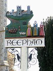 The town sign was designed by the local high school and installed in 1992. It depicts three of each of the following elements: churches, villagers, farm labourers, sheep, lambs and "sisters" and refers to a myth that three sisters were each responsible for building a church. In fact, the three churches were built over several lifetimes.
was on the M&GNs, Norwich City station
to Melton Constable station
branch line. Reepham station
was situated on the GEN
s, Wroxham station to County School station
line. In 1960, the tracks were joined by the construction of the Themelthorpe Curve
. The work was carried out by British Rail
to facilitate the movement of concrete products from Lenwade
. Today, the railway trackbed form the Marriott's Way
long distance footpath. Both former stations are notable stops on the footpath.
Sanders and Eastons Coaches provide bus services to and from the town.
Market town
Market town or market right is a legal term, originating in the medieval period, for a European settlement that has the right to host markets, distinguishing it from a village and city...
in the English
England
England is a country that is part of the United Kingdom. It shares land borders with Scotland to the north and Wales to the west; the Irish Sea is to the north west, the Celtic Sea to the south west, with the North Sea to the east and the English Channel to the south separating it from continental...
county
Counties of the United Kingdom
The counties of the United Kingdom are subnational divisions of the United Kingdom, used for the purposes of administrative, geographical and political demarcation. By the Middle Ages counties had become established as a unit of local government, at least in England. By the early 17th century all...
of Norfolk
Norfolk
Norfolk is a low-lying county in the East of England. It has borders with Lincolnshire to the west, Cambridgeshire to the west and southwest and Suffolk to the south. Its northern and eastern boundaries are the North Sea coast and to the north-west the county is bordered by The Wash. The county...
, England, situated on the B1145 road
B1145 road
The B1145 runs for about through the county of Norfolk, England, between King’s Lynn and Mundesley. The road is an alternative route to the A47 between Kings Lynn and Norwich by way of the A1067 from Bawdeswell onwards.-History:...
between the Bure
River Bure
The River Bure is a river in the county of Norfolk, England, most of it in The Broads. The Bure rises near Melton Constable, upstream of Aylsham, which was the original head of navigation. Nowadays, the head of navigation is downstream at Coltishall Bridge...
and Wensum
River Wensum
The River Wensum is a chalk fed river in Norfolk, England and a tributary of the River Yare despite being the larger of the two rivers. The complete river is a designated Site of Special Scientific Interest and Special Area of Conservation ....
valleys. The town is 12 miles (19.3 km) north west of Norwich
Norwich
Norwich is a city in England. It is the regional administrative centre and county town of Norfolk. During the 11th century, Norwich was the largest city in England after London, and one of the most important places in the kingdom...
. As of the 2001 census the civil parish
Civil parish
In England, a civil parish is a territorial designation and, where they are found, the lowest tier of local government below districts and counties...
had a population of 2,455 residents in 970 households and covers an area of 1909 hectares (4,717.2 acre).
History
The town is mentioned in the Domesday BookDomesday Book
Domesday Book , now held at The National Archives, Kew, Richmond upon Thames in South West London, is the record of the great survey of much of England and parts of Wales completed in 1086...
of 1086 and is listed as Refham meaning the bailiff's
Bailiff
A bailiff is a governor or custodian ; a legal officer to whom some degree of authority, care or jurisdiction is committed...
or reeve's
Reeve (England)
Originally in Anglo-Saxon England the reeve was a senior official with local responsibilities under the Crown e.g. as the chief magistrate of a town or district...
manor from the Old English gerafa (bailiff) and ham (homestead). Reepham has had market town
Market town
Market town or market right is a legal term, originating in the medieval period, for a European settlement that has the right to host markets, distinguishing it from a village and city...
status since 1277; a sign to mark this has recently been erected. The town has undergone significant development throughout its life, with the housing
House
A house is a building or structure that has the ability to be occupied for dwelling by human beings or other creatures. The term house includes many kinds of different dwellings ranging from rudimentary huts of nomadic tribes to free standing individual structures...
in the area showing a mix of vintages, styles and purposes.
The town today
Recent housing developments have mostly been on brownfield landBrownfield land
Brownfield sites are abandoned or underused industrial and commercial facilities available for re-use. Expansion or redevelopment of such a facility may be complicated by real or perceived environmental contaminations. Cf. Waste...
so have not significantly expanded the perimeter of the town.
The town has both a secondary school Reepham High School
Reepham High School
Reepham High School and College is located in Reepham, a small market town in the English county of Norfolk. It is a specialist Science, Applied Learning and Mathematics & Computing centre and has around 1100 pupils on roll. The majority of the students live in outlying villages. Prior to September...
, which achieved the highest grade—Outstanding—in every category in its 2008 Ofsted
Ofsted
The Office for Standards in Education, Children's Services and Skills is the non-ministerial government department of Her Majesty's Chief Inspector of Schools In England ....
inspection, and a primary school (containing over 300 pupils).
The Reepham Society is a registered charity, set up to stimulate public interest in Reepham, Hackford, Kerdiston, Salle, and Whitwell
Whitwell
Whitwell can be a place name in the UK:*Whitwell House, County Durham*Whitwell, Derbyshire*Whitwell Common, Derbyshire*Whitwell, Hertfordshire*Whitwell, Isle of Wight*Whitwell & Reepham railway station, Norfolk*Whitwell, North Yorkshire...
in 1976.
The twin churches
Reepham has three churches on the same site and is one of only two places in EuropeEurope
Europe is, by convention, one of the world's seven continents. Comprising the westernmost peninsula of Eurasia, Europe is generally 'divided' from Asia to its east by the watershed divides of the Ural and Caucasus Mountains, the Ural River, the Caspian and Black Seas, and the waterways connecting...
to do so. Reepham's church of St. Mary is joined by its choir vestry to St. Michael’s and the third church belonged to Hackford. However, this third church burned down in 1543 and now only a fragment of the tower wall remains on the left of the path as you go towards the market place.
The town sign
Railway history
By 1882, the town had two stations, located on different tracks and each managed by a separate railway company.Whitwell stationWhitwell railway station, Norfolk
Whitwell and Reepham railway Station, also known as Whitwell station, is a former station situated in Norfolk, England. The station closed in 1959 and is presently a notable stop on the Marriott's Way long-distance footpath...
was on the M&GNs, Norwich City station
Norwich City railway station
Norwich City railway station was located in Norwich, England and is now closed.-History:The station was opened in 1882 by the Lynn and Fakenham Railway, and later became the southern terminus of the Midland and Great Northern Joint Railway line from Melton Constable...
to Melton Constable station
Melton Constable railway station
Melton Constable was a railway station on the Midland and Great Northern Railway which served the North Norfolk village of Melton Constable from 1882 to 1964...
branch line. Reepham station
Reepham railway station
Reepham was a railway station in Reepham, Norfolk. It was opened in 1882 and closed to passengers in 1952 and finally shut to goods services in 1981...
was situated on the GEN
Great Eastern Railway
The Great Eastern Railway was a pre-grouping British railway company, whose main line linked London Liverpool Street to Norwich and which had other lines through East Anglia...
s, Wroxham station to County School station
County School railway station
County School is a railway station approximately one mile north of the village of North Elmham in the English county of Norfolk. The station is part of a line being gradually restored by the Mid-Norfolk Railway from East Dereham to Fakenham.-History:...
line. In 1960, the tracks were joined by the construction of the Themelthorpe Curve
Themelthorpe
Themelthorpe is a civil parish in the English county of Norfolk, north west of Reepham.It covers an area of and had a population of 65 in 27 households as of the 2001 census.For the purposes of local government, it falls within the district of Broadland....
. The work was carried out by British Rail
British Rail
British Railways , which from 1965 traded as British Rail, was the operator of most of the rail transport in Great Britain between 1948 and 1997. It was formed from the nationalisation of the "Big Four" British railway companies and lasted until the gradual privatisation of British Rail, in stages...
to facilitate the movement of concrete products from Lenwade
Lenwade
Lenwade is a hamlet in the civil parish of Great Witchingham, Norfolk. Located in the Wensum Valley and adjacent to the A1067 road and being south-east of Fakenham and some north-west of Norwich.- Etymology:...
. Today, the railway trackbed form the Marriott's Way
Marriott's Way
The Marriott's Way is a long distance footpath and bridleway which forms part of the National Cycle Network and is open to walkers, cyclists and horse riders between Hellesdon and Aylsham, Norfolk, England...
long distance footpath. Both former stations are notable stops on the footpath.
Public transport
BusSanders and Eastons Coaches provide bus services to and from the town.
Notable residents
- George Goodwin KilburneGeorge Goodwin KilburneGeorge Goodwin Kilburne, R.I., R.O.I, R.M.S, was an English genre painter specialising in accurately drawn interiors with figures...
(1839 – 1924), artist - Keith Simpson, Conservative MP for Mid Norfolk