
RazakSAT
Encyclopedia
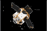
RazakSAT is a Malaysian satellite
carrying a high-resolution camera. It was launched into low Earth orbit
by a Falcon 1
rocket on July 14, 2009. It was placed into a near-equatorial orbit that presents many imaging opportunities for the equatorial region.It weighs over three times a much as TiungSAT-1 and carries a high resolution Earth observation camera. Developed in conjunction with Satrec Initiative, the satellite's low inclination orbit (9 degrees) brought it over Malaysia a dozen or more times per day. This was intended to provide greatly increased coverage of Malaysia, compared to most other Earth observation satellites. An audit report released in October 2011 revealed that the satellite had failed after only 1 year of operation .
satellite after TiungSAT-1.
Originally called MACSAT, RazakSAT's payload is mainly electro-optical, carrying a Medium-sized Aperture Camera (MAC) which is a pushbroom camera with five linear detectors (one panchromatic
, four multi-spectral
) weighing approximately 50 kg. The entire satellite weighs at about 180 kg.
launched RazakSAT at 03:35 UTC on July 14, 2009 using a Falcon 1
rocket. This was the fifth flight of a Falcon 1, and like the previous flights lift-off was from Omelek Island
in the Kwajalein Atoll. At 05:25 UTC Elon Musk
, founder and CEO of SpaceX, told a reporter the launch had been a success. "We nailed the orbit to well within target parameters...pretty much a bullseye." Musk said.
This was especially important because Malaysia is usually covered by the equatorial cloud bands. Normal sun-synchronous optical satellites, which may re-visit an area only once every 7 days, will almost never be able to see the ground during their pass. As a result, much optical satellite imagery of Malaysia have more than 50% cloud cover within the image's footprint.
Razaksat, on the other hand, revisited some parts of Malaysian territory every 90 minutes, potentially maximising its ability to exploit gaps in the clouds.
RazakSAT, equipped with a high resolution Medium-Sized Aperture Camera (MAC), achieved the intended Near-Equatorial Low Earth Orbit (NEqO) at 685 km altitude and a 9 degree inclination. It was expected to provide high resolution images of Malaysia that can be applied to land management, resource development and forestry.
Be that as it may, the NEqO orbit does have 3 distinct disadvantages. Analysis through the commercially available Satellite Tool Kit
(STK) software had shown that the orbit revisit over Malaysia was found to have a maximum peak of 2-4 overpasses per day during daylight hours (from 8 am to 6:30 pm) to a period of 6 consecutive days without any usable daylight overpasses. The second disadvantage is that most imagery acquired through the NEqO orbit are not usable through a remote sensing perspective as the NEqO orbit is not a sun-synchronous orbit, a vital criteria for monitoring and analysis work. Thirdly, it was found that the NEqO orbit exposes the satellite to the South Atlantic Anomaly
(SAA) phenomenon on every orbit it takes around the earth unlike the polar orbit
, near-polar or sun-synchronous orbits, thereby further increasing the risk of radiation damage to the satellite.
Originally slated for commercial purposes in 2009,
the aim of the RazakSAT project was then changed into a Research & Development (R&D) Project in 2010 .
During its operations after its launch in 2009, it was discovered that the RazakSAT satellite could not achieve its targeted pointing accuracy of within 1km of its intended target . The Malaysian English newspaper The Star, quoting from the Malaysian Government Auditor-General's Report 2010, reported that the images that were acquired by the RazakSAT satellite was found to be 37 km off their intended target..
As a result of the pointing error, all of the over 1,328 images acquired by the satellite were rendered unusable. Despite a promise of delivering MAC images by 2010, the operators have not released any images. Efforts to fix the problems with the satellite were terminated in December 2010.
used for RazakSAT was jointly developed by ATSB and Satrec Initiative, a commercial satellite manufacturer in Korea. Satrec Initiative markets the bus system as the "SI-200".
RazakSAT first images. Click MOSTI Gallery > Year 2009 > Galeri Gambar Pelancaran RazakSAT
Satellite
In the context of spaceflight, a satellite is an object which has been placed into orbit by human endeavour. Such objects are sometimes called artificial satellites to distinguish them from natural satellites such as the Moon....
carrying a high-resolution camera. It was launched into low Earth orbit
Low Earth orbit
A low Earth orbit is generally defined as an orbit within the locus extending from the Earth’s surface up to an altitude of 2,000 km...
by a Falcon 1
Falcon 1
The Falcon 1 is a partially reusable launch system designed and manufactured by SpaceX, a space transportation company in Hawthorne, California. The two-stage-to-orbit rocket uses LOX/RP-1 for both stages, the first powered by a single Merlin engine and the second powered by a single Kestrel engine...
rocket on July 14, 2009. It was placed into a near-equatorial orbit that presents many imaging opportunities for the equatorial region.It weighs over three times a much as TiungSAT-1 and carries a high resolution Earth observation camera. Developed in conjunction with Satrec Initiative, the satellite's low inclination orbit (9 degrees) brought it over Malaysia a dozen or more times per day. This was intended to provide greatly increased coverage of Malaysia, compared to most other Earth observation satellites. An audit report released in October 2011 revealed that the satellite had failed after only 1 year of operation .
Background
This satellite is Malaysia's second remote sensingRemote sensing
Remote sensing is the acquisition of information about an object or phenomenon, without making physical contact with the object. In modern usage, the term generally refers to the use of aerial sensor technologies to detect and classify objects on Earth by means of propagated signals Remote sensing...
satellite after TiungSAT-1.
Originally called MACSAT, RazakSAT's payload is mainly electro-optical, carrying a Medium-sized Aperture Camera (MAC) which is a pushbroom camera with five linear detectors (one panchromatic
Panchromatic
Panchromatic film is a type of black-and-white photographic film that is sensitive to all wavelengths of visible light. A panchromatic film therefore produces a realistic reproduction of a scene as it appears to the human eye. Almost all modern photographic film is panchromatic, but some types are...
, four multi-spectral
Multi-spectral image
A multispectral image is one that captures image data at specific frequencies across the electromagnetic spectrum. The wavelengths may be separated by filters or by the use of instruments that are sensitive to particular wavelengths, including light from frequencies beyond the visible light range,...
) weighing approximately 50 kg. The entire satellite weighs at about 180 kg.
Launch
SpaceXSpaceX
Space Exploration Technologies Corporation, or more popularly and informally known as SpaceX, is an American space transport company that operates out of Hawthorne, California...
launched RazakSAT at 03:35 UTC on July 14, 2009 using a Falcon 1
Falcon 1
The Falcon 1 is a partially reusable launch system designed and manufactured by SpaceX, a space transportation company in Hawthorne, California. The two-stage-to-orbit rocket uses LOX/RP-1 for both stages, the first powered by a single Merlin engine and the second powered by a single Kestrel engine...
rocket. This was the fifth flight of a Falcon 1, and like the previous flights lift-off was from Omelek Island
Omelek Island
Omelek Island is part of the Kwajalein Atoll in the Republic of the Marshall Islands. It is controlled by the United States military under a long-term lease and is part of the Ronald Reagan Ballistic Missile Defense Test Site.-Geography:The Island is about in size...
in the Kwajalein Atoll. At 05:25 UTC Elon Musk
Elon Musk
Elon Musk is an American engineer and entrepreneur heritage best known for co-founding PayPal, SpaceX and Tesla Motors. He is currently the CEO and CTO of SpaceX, CEO and Product Architect of Tesla Motors and Chairman of SolarCity...
, founder and CEO of SpaceX, told a reporter the launch had been a success. "We nailed the orbit to well within target parameters...pretty much a bullseye." Musk said.
Operations
RazakSAT's mission plan was carried out by engineers from ATSB.This was especially important because Malaysia is usually covered by the equatorial cloud bands. Normal sun-synchronous optical satellites, which may re-visit an area only once every 7 days, will almost never be able to see the ground during their pass. As a result, much optical satellite imagery of Malaysia have more than 50% cloud cover within the image's footprint.
Razaksat, on the other hand, revisited some parts of Malaysian territory every 90 minutes, potentially maximising its ability to exploit gaps in the clouds.
RazakSAT, equipped with a high resolution Medium-Sized Aperture Camera (MAC), achieved the intended Near-Equatorial Low Earth Orbit (NEqO) at 685 km altitude and a 9 degree inclination. It was expected to provide high resolution images of Malaysia that can be applied to land management, resource development and forestry.
Be that as it may, the NEqO orbit does have 3 distinct disadvantages. Analysis through the commercially available Satellite Tool Kit
A
A is the first letter and a vowel in the basic modern Latin alphabet. It is similar to the Ancient Greek letter Alpha, from which it derives.- Origins :...
(STK) software had shown that the orbit revisit over Malaysia was found to have a maximum peak of 2-4 overpasses per day during daylight hours (from 8 am to 6:30 pm) to a period of 6 consecutive days without any usable daylight overpasses. The second disadvantage is that most imagery acquired through the NEqO orbit are not usable through a remote sensing perspective as the NEqO orbit is not a sun-synchronous orbit, a vital criteria for monitoring and analysis work. Thirdly, it was found that the NEqO orbit exposes the satellite to the South Atlantic Anomaly
South Atlantic Anomaly
The South Atlantic Anomaly is an area where the Earth's inner Van Allen radiation belt comes closest to the Earth's surface. This leads to an increased flux of energetic particles in this region and exposes orbiting satellites to higher than usual levels of radiation...
(SAA) phenomenon on every orbit it takes around the earth unlike the polar orbit
Polar orbit
A polar orbit is an orbit in which a satellite passes above or nearly above both poles of the body being orbited on each revolution. It therefore has an inclination of 90 degrees to the equator...
, near-polar or sun-synchronous orbits, thereby further increasing the risk of radiation damage to the satellite.
Originally slated for commercial purposes in 2009,
the aim of the RazakSAT project was then changed into a Research & Development (R&D) Project in 2010 .
During its operations after its launch in 2009, it was discovered that the RazakSAT satellite could not achieve its targeted pointing accuracy of within 1km of its intended target . The Malaysian English newspaper The Star, quoting from the Malaysian Government Auditor-General's Report 2010, reported that the images that were acquired by the RazakSAT satellite was found to be 37 km off their intended target..
As a result of the pointing error, all of the over 1,328 images acquired by the satellite were rendered unusable. Despite a promise of delivering MAC images by 2010, the operators have not released any images. Efforts to fix the problems with the satellite were terminated in December 2010.
Specifications
The major specification of RazakSAT, as provided by the satellites' builder and operator (ATSB) in February 2010, are:| Subsystems | Specifications |
|---|---|
| Altitude | 685 km |
| Inclination | 9 ° |
| Payload (MAC) | GSD : 2.5 m (PAN), 5 m (MS) Swathwidth : 20 km @ 685 km |
| Attitude Determination & Control Subsystem (ADCS) | Three-axis stabilization based on four reaction wheels Pointing Accuracy : < 0.2° (2 s) Pointing Knowledge : 1 arcmin (2 s) |
| Electrical Power Subsystem (EPS) | GaAs/Ge solar cells on honeycomb substrate NiCd batteries (18 Ahr) Peak Power Tracking (PPT) & constant current control Solar Power : >300 W @ EOL |
| Command & Data Handling Subsystem (C&DH) | Two on-board computers Telemetry and command interface modules Analog Telemetry channels : up to 90 Digital Telemetry channels : up to 120 |
| Telecommunication Subsystem (TS) | 9,600 bit/s / 1,200 bit/s S-band TT&C uplink 38.4 kbs / 9,600 bit/s / 1,200 bit/s S-band TT&C downlink |
| Payload Data Management | 32 Gbit On-board solid-state memory 30 Mbit/s X band X band The X band is a segment of the microwave radio region of the electromagnetic spectrum. In some cases, such as in communication engineering, the frequency range of X band is rather indefinitely set at approximately 7.0 to 11.2 gigahertz . In radar engineering, the frequency range is specified... payload data downlink |
| Structure & Thermal | Ø1,200 × 1,200 mm Hexagonal shape Mass : 180 kg Modular structure Passive & Active thermal control |
| Mission Lifetime | > 3 Years |
Satellite bus
The satellite busSatellite bus
A satellite bus or spacecraft bus is the general model on which multiple-production satellite spacecraft are often based. The bus is the infrastructure of a spacecraft, usually providing locations for the payload .They are most commonly used for geosynchronous satellites, particularly...
used for RazakSAT was jointly developed by ATSB and Satrec Initiative, a commercial satellite manufacturer in Korea. Satrec Initiative markets the bus system as the "SI-200".
External links
- http://www.atsb.my/index.php/project/space-systems/razaksatr.html
- http://web.archive.org/web/20070927185734/http://www.asmmag.com/ASM/content/2006/ASM_032/main_news_5.html
- http://www.mosti.gov.my/mosti
- http://thestar.com.my/news/story.asp?sec=nation&file=/2009/3/22/nation/3534086
RazakSAT first images. Click MOSTI Gallery > Year 2009 > Galeri Gambar Pelancaran RazakSAT
- http://www.mosti.gov.my/mosti/index.php?option=com_content&task=view&id=1623&Itemid=572