

Radnevo Peak
Encyclopedia
Vidin Heights
Vidin Heights are predominantly ice-covered heights rising to 604 m on Varna Peninsula, eastern Livingston Island in the South Shetland Islands, Antarctica. The feature is approximately 8 km long from the north end of Leslie Gap east-northeastwards to Inott Point and 9.6 km...
on Varna Peninsula
Varna Peninsula
Varna Peninsula is a roughly rectangular predominantly ice-covered peninsula forming the northeast extremity of Livingston Island in the South Shetland Islands, Antarctica...
on Livingston Island in the South Shetland Islands
South Shetland Islands
The South Shetland Islands are a group of Antarctic islands, lying about north of the Antarctic Peninsula, with a total area of . By the Antarctic Treaty of 1959, the Islands' sovereignty is neither recognized nor disputed by the signatories and they are free for use by any signatory for...
, Antarctica. Surmounting Kaliakra Glacier
Kaliakra Glacier
Kaliakra Glacier is a glacier in northeastern Livingston Island, Antarctica extending 7 km in east-west direction and 8 km in north-south direction...
to the southeast and Saedinenie Snowfield
Saedinenie Snowfield
Saedinenie Snowfield on Livingston Island in the South Shetland Islands, Antarctica, is bounded by Teres Ridge to the west, the glacial divide between the Drake Passage and Bransfield Strait to the south, Gleaner Heights, Elhovo Gap and Leslie Hill to the southeast, and Leslie Gap and Vidin...
to the northwest. Linked to Leslie Hill
Leslie Hill, Livingston Island
Leslie Hill is a hill lying northward of Bowles Ridge and south of Vidin Heights in the eastern part of Livingston Island in the South Shetland Islands, Antarctica...
by Leslie Gap
Leslie Gap
Leslie Gap is an 359m high ice-covered saddle extending 2.8 km in south-north direction between Leslie Hill and Radnevo Peak on Varna Peninsula in northeastern Livingston Island in the South Shetland Islands, Antarctica. The saddle separates the glacial catchments of Kaliakra Glacier to the...
. The peak is named after the town of Radnevo
Radnevo
Radnevo is a town in southern Bulgaria, part of Stara Zagora Province, located in the eastern Upper Thracian Lowlands close to the Maritsa Iztok Complex. It is the administrative centre of the homonymous Radnevo Municipality...
in Southeastern Bulgaria
Bulgaria
Bulgaria , officially the Republic of Bulgaria , is a parliamentary democracy within a unitary constitutional republic in Southeast Europe. The country borders Romania to the north, Serbia and Macedonia to the west, Greece and Turkey to the south, as well as the Black Sea to the east...
.
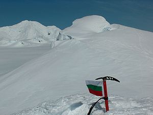
First ascent by Lyubomir Ivanov from Camp Academia
Camp Academia
Camp Academia is a geographical locality in eastern Livingston Island, South Shetland Islands, Antarctica, named for the Bulgarian Academy of Sciences in appreciation of Academy’s contribution to the Antarctic exploration...
on 25 December 2004.
Location
The peak is located at 62°32′36.4"S 60°10′37"W which is 1.08 km southwest of Miziya PeakMiziya Peak
Miziya Peak is the 604 m summit of Vidin Heights on Varna Peninsula, eastern Livingston Island in the South Shetland Islands, Antarctica...
, 2.42 km west of Samuel Peak
Samuel Peak
Samuel Peak is the 540 m peak in central Vidin Heights, Livingston Island in the South Shetland Islands, Antarctica. Surmounting Panega Glacier to the east and Kaliakra Glacier to the south....
, 6.61 km north-northwest of Melnik Peak
Melnik Peak
Melnik Peak is the 696 m summit of Melnik Ridge in eastern Livingston Island, South Shetland Islands in Antarctica. Surmounting Kaliakra Glacier to the north and west, and Struma Glacier to the southeast...
and 3.16 km north-northeast of Leslie Hill (Bulgarian mapping in 2005 and 2009 from the Tangra 2004/05
Tangra 2004/05
The Tangra 2004/05 Expedition was commissioned by the Antarctic Place-names Commission at the Ministry of Foreign Affairs of Bulgaria, managed by the Manfred Wörner Foundation, and supported by the Bulgarian Antarctic Institute, the Institute of Mathematics and Informatics at the Bulgarian Academy...
topographic survey).
Maps
- L.L. Ivanov et al. Antarctica: Livingston Island and Greenwich Island, South Shetland Islands. Scale 1:100000 topographic map. Sofia: Antarctic Place-names Commission of Bulgaria, 2005.
- L.L. Ivanov. Antarctica: Livingston Island and Greenwich, Robert, Snow and Smith Islands. Scale 1:120000 topographic map. Troyan: Manfred Wörner Foundation, 2009.