

Rabaul Airport
Encyclopedia
Rabaul Airport, also called Tokua Airport, is an airport serving Kokopo
and Rabaul
, the current and former capitals of East New Britain Province on New Britain
island in Papua New Guinea
.
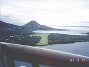 Prior to the 1994 volcanic eruption that destroyed the town of Rabaul
, the airport was located at the foot of Tavurvur
volcano, near Matupit island. The airport was destroyed by the eruption, and subsequently the new airport was built and opened at Tokua, on the opposite side of the Rabaul caldera
. The former airport was located at 04°13′S 152°11′E.
A volcano eruption closed the airport for a day in 2006.
of 32 feet (10 m) above mean sea level. It has one runway
designated 10/28 with an asphalt
surface measuring 5643 by 92 ft (1,720 by 28 ).
Kokopo
Kokopo is the capital of East New Britain in Papua New Guinea. The capital was moved from Rabaul in 1994 when the volcanoes Tavurvur and Vulcan erupted. As a result, the population of the town increased more than sixfold from 3,150 in 1990 to 20,262 in 2000....
and Rabaul
Rabaul
Rabaul is a township in East New Britain province, Papua New Guinea. The town was the provincial capital and most important settlement in the province until it was destroyed in 1994 by falling ash of a volcanic eruption. During the eruption, ash was sent thousands of metres into the air and the...
, the current and former capitals of East New Britain Province on New Britain
New Britain
New Britain, or Niu Briten, is the largest island in the Bismarck Archipelago of Papua New Guinea. It is separated from the island of New Guinea by the Dampier and Vitiaz Straits and from New Ireland by St. George's Channel...
island in Papua New Guinea
Papua New Guinea
Papua New Guinea , officially the Independent State of Papua New Guinea, is a country in Oceania, occupying the eastern half of the island of New Guinea and numerous offshore islands...
.
Rabaul
Rabaul is a township in East New Britain province, Papua New Guinea. The town was the provincial capital and most important settlement in the province until it was destroyed in 1994 by falling ash of a volcanic eruption. During the eruption, ash was sent thousands of metres into the air and the...
, the airport was located at the foot of Tavurvur
Tavurvur
Tavurvur is an active volcano that lies near Rabaul in Papua New Guinea. It is a sub-vent of the Rabaul caldera and lies on the eastern rim of the larger feature...
volcano, near Matupit island. The airport was destroyed by the eruption, and subsequently the new airport was built and opened at Tokua, on the opposite side of the Rabaul caldera
Rabaul caldera
Rabaul caldera is a large volcano situated in East New Britain, Papua New Guinea. It derives its name from the town of Rabaul situated inside the caldera. The highest of its multiple peaks is ....
. The former airport was located at 04°13′S 152°11′E.
A volcano eruption closed the airport for a day in 2006.
Facilities
The airport resides at an elevationElevation
The elevation of a geographic location is its height above a fixed reference point, most commonly a reference geoid, a mathematical model of the Earth's sea level as an equipotential gravitational surface ....
of 32 feet (10 m) above mean sea level. It has one runway
Runway
According to ICAO a runway is a "defined rectangular area on a land aerodrome prepared for the landing and take-off of aircraft." Runways may be a man-made surface or a natural surface .- Orientation and dimensions :Runways are named by a number between 01 and 36, which is generally one tenth...
designated 10/28 with an asphalt
Asphalt
Asphalt or , also known as bitumen, is a sticky, black and highly viscous liquid or semi-solid that is present in most crude petroleums and in some natural deposits, it is a substance classed as a pitch...
surface measuring 5643 by 92 ft (1,720 by 28 ).