

R116 road
Encyclopedia

Regional road
A regional road in Ireland is a class of road not forming a major route , but nevertheless forming a link in the national route network. There are over 11,600 kilometres of regional roads. Regional roads are numbered with three digit route numbers, prefixed by "R" A regional road in Ireland is a...
in Ireland
Republic of Ireland
Ireland , described as the Republic of Ireland , is a sovereign state in Europe occupying approximately five-sixths of the island of the same name. Its capital is Dublin. Ireland, which had a population of 4.58 million in 2011, is a constitutional republic governed as a parliamentary democracy,...
which runs east-west from the N11 at Loughlinstown
Loughlinstown
Loughlinstown is a south Dublin suburb. Located in the County of Dun Laoghaire-Rathdown it lies on the N11 National Primary Route.Loughlinstown is the location of St. Columcille's Hospital, which serves both south Dublin and north Wicklow...
to the R115
R115 road
The R115 road is a regional road in counties Dublin and Wicklow in Ireland. It follows the Military Road for its entire length. The R115 is long; the full length of the Military Road is...
in Ballyboden
Ballyboden
Ballyboden is a locality within the suburb of Rathfarnham in South Dublin, at the foot of the Dublin mountains between Whitechurch, Ballyroan and Knocklyon....
. It runs through the South of County Dublin
County Dublin
County Dublin is a county in Ireland. It is part of the Dublin Region and is also located in the province of Leinster. It is named after the city of Dublin which is the capital of Ireland. County Dublin was one of the first of the parts of Ireland to be shired by King John of England following the...
for its entire length.
Route
The official definition of the R116 from the Roads Act 1993 (Classification of Regional Roads) Order 2006 reads:- R116: Ballyboden - Loughlinstown, County Dublin
- Between its junction with R115 at Scholarstown Road in the county of South Dublin and its junction with R117 at Kiltiernan in the county of DunLaoghaire - Rathdown via Edmondstown Road and Cruagh in the county of South Dublin: Tibradden, Glencullen and Ballybetagh all in the county of DunLaoghaire - Rathdown
-
-
- and
-
- between its junction with R117 at Glenamuck South and its junction with N11 at Loughlinstown via Ballycorus Road, Rathmichael Road, Stonebridge Road, Mullinastill Road and Cherrywood Road all in the county of Dun Laoghaire - Rathdown.
Description
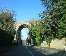
East-West:Starts at N11 Cherrywood Road and runs under the old Harcourt Street railway line viaduct and on through Brides Glen where it goes under the M50
M50 motorway (Ireland)
The M50 motorway is a motorway in Ireland running in a C-shaped ring around the north-eastern, northern, western and southern sides of the capital city, Dublin. The northern end of the route is located at the entrance to the Dublin Port Tunnel. Anti-clockwise it heads northwest through the tunnel...
and crosses over the Loughlinstown River. Proceeds east along Ballycorus Road to a junction with the R117
R117 road
The R117 road is a regional road in Ireland. The route starts Harcourt Road at the end of the South Circular Road on the southside of Dublin city centre...
in Kilternan
Kilternan
Kilternan is a village in County of Dún Laoghaire-Rathdown, in the foothills of the Dublin Mountains south of Dublin, near the border with County Wicklow....
. Crosses the R117 at a staggered junction in Kilternan before climbing steeply SW up Ballybetagh Road to Glencullen
Glencullen
Glencullen , is a village in south County Dublin. It is also a townland in the civil parish of Kilternan, in the Barony and Poor Law Union of Rathdown in Dun Laoghaire-Rathdown County....
.
Continues east along the northern side of a deep valley formed by Two Rock Mountain (536 m) and Tibradden Mountain
Tibradden Mountain
Tibradden Mountain is a mountain in County Dublin in Ireland. Other names for the mountain include "Garrycastle" and "Kilmainham Begg" . It is high and is the 561st highest mountain in Ireland...
to the north and Glendoo Mountain (586 m) to the south, where it reaches its high point of 287m (1,263ft). From the head of the valley it descends steeply through the Pine Forest and continues down through Rockbrook
Rockbrook
Rockbrook is a small area in South Dublin. It situated south of Ballyboden on the R116 regional road, and is the site of the Rockbrook Park School boys secondary school....
and Edmondstown
Edmondstown
Edmondstown is an area in South Dublin. It situated on the R116 regional road, south of Ballyboden and north of Rockbrook, in the valley of the Oewdoher River. Edmondstown National School is a senior primary school which serves the local area. The school principal is Mr.Damien Burke.The school...
(where it again passes underneath the M50) to its termination in Ballyboden where it meets the R115.