
Quaboag Pond
Encyclopedia
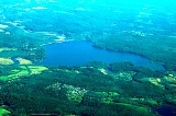
Quaboag Pond is a 537 acres (2.2 km²) pond located near the East Brookfield
and Brookfield, Massachusetts
. The pond lies about two miles (3 km) south of state Route 9
as it passes through East Brookfield
. Quaboag Pond was once named Podunk Pond.
Local swamps feed Quaboag Pond as well as inflow from the East Brookfield River
, a two-mile (3.22 km) long river that heads at the Lake Lashaway
Dam, and Quacumquasit Pond to its south. Some documents do not acknowledge the existence of the East Brookfield River
and instead refer to this waterway as the Seven Mile River
. This is unfortunate because it is the Five Mile River
that the Lake Lashaway Dam impounds creating Lake Lashaway
, which feeds this river, not the Seven Mile. Quaboag Pond is part of the Chicopee River Watershed and it drains into the Quaboag River
.
, which flows into this pond, offers good fishing for many warm water fish. A survey conducted in 1994 showed thirteen species including Large and Small-mouth Bass, Chain Pickerel, Yellow Perch, White Perch, Black Crappie, Bluegill, Pumpkinseed, Brown and Yellow Bullhead, Golden Shiner, and Sucker. Lake Lashaway
was stocked with Northern Pike in the past.
East Brookfield, Massachusetts
East Brookfield is a town in Worcester County, Massachusetts, United States. The population was 2,183 at the 2010 census.For geographic and demographic information on the census-designated place East Brookfield, please see the article East Brookfield , Massachusetts.- History :East Brookfield was...
and Brookfield, Massachusetts
Brookfield, Massachusetts
Brookfield is a town in Worcester County, Massachusetts, United States. The population was 3,390 at the 2010 census.-History:Brookfield was first settled in 1660 and was officially incorporated in 1718...
. The pond lies about two miles (3 km) south of state Route 9
Route 9 (Massachusetts)
Route 9 is a major east–west state highway in Massachusetts. Along with U.S. Route 20, Route 2 and the Massachusetts Turnpike, Route 9 is one of the major east-west routes of Massachusetts, and like the others its eastern terminus is in Boston...
as it passes through East Brookfield
East Brookfield, Massachusetts
East Brookfield is a town in Worcester County, Massachusetts, United States. The population was 2,183 at the 2010 census.For geographic and demographic information on the census-designated place East Brookfield, please see the article East Brookfield , Massachusetts.- History :East Brookfield was...
. Quaboag Pond was once named Podunk Pond.
Description
The average depth is 7 feet (2.13 m) with the maximum depth about 10 feet (3.05 m). The water is brown in color and quite warm in the summertime. Non-native invasive plants cover substantial portions of this pond; the pond lies in a swampy area, also subject to the invasive species.Local swamps feed Quaboag Pond as well as inflow from the East Brookfield River
East Brookfield River
The East Brookfield River is a river in Massachusetts that heads at Lake Lashaway in East Brookfield at an elevation of above sea level. It continues to Quaboag Pond, at an elevation of .-History:...
, a two-mile (3.22 km) long river that heads at the Lake Lashaway
Lake Lashaway
Lake Lashaway is a pond located near the East Brookfield and North Brookfield, Massachusetts town line. The town line cuts the lake approximately in half. The lake lies just to the north of state Route 9 as it passes through East Brookfield.-Description:...
Dam, and Quacumquasit Pond to its south. Some documents do not acknowledge the existence of the East Brookfield River
East Brookfield River
The East Brookfield River is a river in Massachusetts that heads at Lake Lashaway in East Brookfield at an elevation of above sea level. It continues to Quaboag Pond, at an elevation of .-History:...
and instead refer to this waterway as the Seven Mile River
Seven Mile River (East Brookfield River)
The Seven Mile River or Sevenmile River is a stream in central Massachusetts. It heads at Browning Pond, at the Oakham and Spencer border, and travels south through Spencer, following a short distance from State Route 31...
. This is unfortunate because it is the Five Mile River
Five Mile River (Quaboag River)
The Five Mile River is a river in central Massachusetts, part of the Chicopee River watershed. It rises north of Denn Pond in the town of Oakham within Rutland State Forest and flows south through Denn Pond to Brooks Pond, northeast of North Brookfield, then continues south to its mouth at the...
that the Lake Lashaway Dam impounds creating Lake Lashaway
Lake Lashaway
Lake Lashaway is a pond located near the East Brookfield and North Brookfield, Massachusetts town line. The town line cuts the lake approximately in half. The lake lies just to the north of state Route 9 as it passes through East Brookfield.-Description:...
, which feeds this river, not the Seven Mile. Quaboag Pond is part of the Chicopee River Watershed and it drains into the Quaboag River
Quaboag River
The Quaboag River is a river in Massachusetts that heads at Quaboag Pond in Brookfield at an elevation of above sea level. It flows west to the village of Three Rivers, Massachusetts, at an elevation of .-History:...
.
Fishing
Lake LashawayLake Lashaway
Lake Lashaway is a pond located near the East Brookfield and North Brookfield, Massachusetts town line. The town line cuts the lake approximately in half. The lake lies just to the north of state Route 9 as it passes through East Brookfield.-Description:...
, which flows into this pond, offers good fishing for many warm water fish. A survey conducted in 1994 showed thirteen species including Large and Small-mouth Bass, Chain Pickerel, Yellow Perch, White Perch, Black Crappie, Bluegill, Pumpkinseed, Brown and Yellow Bullhead, Golden Shiner, and Sucker. Lake Lashaway
Lake Lashaway
Lake Lashaway is a pond located near the East Brookfield and North Brookfield, Massachusetts town line. The town line cuts the lake approximately in half. The lake lies just to the north of state Route 9 as it passes through East Brookfield.-Description:...
was stocked with Northern Pike in the past.