
West Brookfield, Massachusetts
Encyclopedia
West Brookfield is a town in Worcester County
, Massachusetts
, United States
. The population was 3,701 at the 2010 census. Lucy Stone
was born in West Brookfield, and Noah Webster
published his dictionary there.
For geographic and demographic information on the census-designated place
West Brookfield, please see the article West Brookfield (CDP)
, Massachusetts
.
.
The town is believed to be the birthplace of asparagus in the New World. Diederik Leertouwer came to the United States in 1784 to promote trade between the Netherlands and New England. He later settled with his wife and daughter in West Brookfield where he carried out his duties as Consul and lived here between the years 1794 and 1798. At that time West Brookfield had a population greater than Worcester
and was being considered for the county seat. Local legend has it that Diederik Leertouwer imported asparagus from his homeland and was the first to plant it in this area. This fact was forgotten until it was discovered in an old cookbook. Wild asparagus still grows in this area today. Leertouwer died here and is buried in the Old Indian Cemetery on Cottage Street in West Brookfield.
The town is also home to the Rock House Reservation
, a massive, cave-like rock shelter, exposed after the glacial retreat 10,000 years ago, that served as a winter camp for Native Americans. By the mid 1800s, it was part of a farm owned by William Adams whose descendant, F. A. Carter, dammed a small stream to create Carter Pond and built the cottage now serving as a trailside museum and nature center. The reservation is open year round, daily, sunrise to sunset. Admission is free to all.
, the town has a total area of 21.1 square miles (54.6 km²), of which 20.5 square miles (53.1 km²) is land and 0.6 square miles (1.6 km²), or 3.03%, is water. West Brookfield is bounded on the southeast by Brookfield
, on the north by North Brookfield
, on the north by New Braintree
, on the west by Ware
and on the southwest by Warren
.
of 2000, there were 3,804 people, 1,362 households, and 965 families residing in the town. The population density
was 185.8 people per square mile (71.8/km²). There were 1,534 housing units at an average density of 74.9 per square mile (28.9/km²). The racial makeup of the town was 98.16% White, 0.32% Black or African American
, 0.24% Native American, 0.24% Asian, 0.05% Pacific Islander, 0.16% from other races
, and 0.84% from two or more races. Hispanic or Latino of any race were 1.05% of the population.
There were 1,362 households out of which 33.6% had children under the age of 18 living with them, 59.4% were married couples
living together, 8.7% had a female householder with no husband present, and 29.1% were non-families. 23.6% of all households were made up of individuals and 10.4% had someone living alone who was 65 years of age or older. The average household size was 2.53 and the average family size was 3.01.
In the town the population was spread out with 22.9% under the age of 18, 5.3% from 18 to 24, 25.7% from 25 to 44, 25.1% from 45 to 64, and 20.9% who were 65 years of age or older. The median age was 43 years. For every 100 females there were 81.7 males. For every 100 females age 18 and over, there were 78.3 males.
The median income for a household in the town was $49,722, and the median income for a family was $58,750. Males had a median income of $41,211 versus $29,783 for females. The per capita income
for the town was $21,501. About 4.0% of families and 6.8% of the population were below the poverty line, including 9.9% of those under age 18 and 4.6% of those age 65 or over.
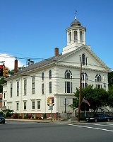
The exterior of the Library remains relatively unchanged with the exception of a cupola, which was destroyed in the Hurricane of '38. Also, an elevator tower was discreetly added during the 1997 building renovation project that both refurbished and made the building accessible to the handicapped.
In fiscal year 2008, the town of West Brookfield spent 3.11% ($167,532) of its budget on its public library—some $44 per person.
; students in grades 7-12 from both towns attend Quaboag Regional Middle-High School in Warren.
Worcester County, Massachusetts
-Demographics:In 1990 Worcester County had a population of 709,705.As of the census of 2000, there were 750,963 people, 283,927 households, and 192,502 families residing in the county. The population density was 496 people per square mile . There were 298,159 housing units at an average density...
, Massachusetts
Massachusetts
The Commonwealth of Massachusetts is a state in the New England region of the northeastern United States of America. It is bordered by Rhode Island and Connecticut to the south, New York to the west, and Vermont and New Hampshire to the north; at its east lies the Atlantic Ocean. As of the 2010...
, United States
United States
The United States of America is a federal constitutional republic comprising fifty states and a federal district...
. The population was 3,701 at the 2010 census. Lucy Stone
Lucy Stone
Lucy Stone was a prominent American abolitionist and suffragist, and a vocal advocate and organizer promoting rights for women. In 1847, Stone was the first woman from Massachusetts to earn a college degree. She spoke out for women's rights and against slavery at a time when women were discouraged...
was born in West Brookfield, and Noah Webster
Noah Webster
Noah Webster was an American educator, lexicographer, textbook pioneer, English spelling reformer, political writer, editor, and prolific author...
published his dictionary there.
For geographic and demographic information on the census-designated place
Census-designated place
A census-designated place is a concentration of population identified by the United States Census Bureau for statistical purposes. CDPs are delineated for each decennial census as the statistical counterparts of incorporated places such as cities, towns and villages...
West Brookfield, please see the article West Brookfield (CDP)
West Brookfield (CDP), Massachusetts
West Brookfield is a census-designated place in the town of West Brookfield in Worcester County, Massachusetts, United States. The population was 1,413 at the 2010 census.-Geography:...
, Massachusetts
Massachusetts
The Commonwealth of Massachusetts is a state in the New England region of the northeastern United States of America. It is bordered by Rhode Island and Connecticut to the south, New York to the west, and Vermont and New Hampshire to the north; at its east lies the Atlantic Ocean. As of the 2010...
.
History
West Brookfield was first settled in 1664 and was officially incorporated in 1848, splitting off from BrookfieldBrookfield, Massachusetts
Brookfield is a town in Worcester County, Massachusetts, United States. The population was 3,390 at the 2010 census.-History:Brookfield was first settled in 1660 and was officially incorporated in 1718...
.
The town is believed to be the birthplace of asparagus in the New World. Diederik Leertouwer came to the United States in 1784 to promote trade between the Netherlands and New England. He later settled with his wife and daughter in West Brookfield where he carried out his duties as Consul and lived here between the years 1794 and 1798. At that time West Brookfield had a population greater than Worcester
Worcester, Massachusetts
Worcester is a city and the county seat of Worcester County, Massachusetts, United States. Named after Worcester, England, as of the 2010 Census the city's population is 181,045, making it the second largest city in New England after Boston....
and was being considered for the county seat. Local legend has it that Diederik Leertouwer imported asparagus from his homeland and was the first to plant it in this area. This fact was forgotten until it was discovered in an old cookbook. Wild asparagus still grows in this area today. Leertouwer died here and is buried in the Old Indian Cemetery on Cottage Street in West Brookfield.
The town is also home to the Rock House Reservation
Rock House Reservation
The Rock House Reservation is a open space preserve located in West Brookfield, Massachusetts. The property, acquired in 1993 by the land conservation non-profit organization The Trustees of Reservations, is named for a natural rock shelter once used as a winter camp by Native Americans.Its...
, a massive, cave-like rock shelter, exposed after the glacial retreat 10,000 years ago, that served as a winter camp for Native Americans. By the mid 1800s, it was part of a farm owned by William Adams whose descendant, F. A. Carter, dammed a small stream to create Carter Pond and built the cottage now serving as a trailside museum and nature center. The reservation is open year round, daily, sunrise to sunset. Admission is free to all.
Geography
According to the United States Census BureauUnited States Census Bureau
The United States Census Bureau is the government agency that is responsible for the United States Census. It also gathers other national demographic and economic data...
, the town has a total area of 21.1 square miles (54.6 km²), of which 20.5 square miles (53.1 km²) is land and 0.6 square miles (1.6 km²), or 3.03%, is water. West Brookfield is bounded on the southeast by Brookfield
Brookfield, Massachusetts
Brookfield is a town in Worcester County, Massachusetts, United States. The population was 3,390 at the 2010 census.-History:Brookfield was first settled in 1660 and was officially incorporated in 1718...
, on the north by North Brookfield
North Brookfield, Massachusetts
North Brookfield is a town in Worcester County, Massachusetts, United States. The population was 4,680 at the 2010 census.For geographic and demographic information on the census-designated place North Brookfield, please see the article North Brookfield , Massachusetts.- History :North Brookfield...
, on the north by New Braintree
New Braintree, Massachusetts
New Braintree is a town in Worcester County, Massachusetts, United States. The population was 999 at the 2010 census.- History :New Braintree was first settled in 1709 and was officially incorporated in 1751....
, on the west by Ware
Ware, Massachusetts
Ware is a town in Hampshire County, Massachusetts, United States. The population was 9,707 at the 2000 census. It is part of the Springfield, Massachusetts Metropolitan Statistical Area.Part of the town comprises the census-designated place of Ware....
and on the southwest by Warren
Warren, Massachusetts
Warren is a town in Worcester County, Massachusetts, United States. The population was 5,135 at the 2010 census.For geographic and demographic information on the census-designated place Warren, please see the article Warren , Massachusetts.- History :...
.
Demographics
As of the censusCensus
A census is the procedure of systematically acquiring and recording information about the members of a given population. It is a regularly occurring and official count of a particular population. The term is used mostly in connection with national population and housing censuses; other common...
of 2000, there were 3,804 people, 1,362 households, and 965 families residing in the town. The population density
Population density
Population density is a measurement of population per unit area or unit volume. It is frequently applied to living organisms, and particularly to humans...
was 185.8 people per square mile (71.8/km²). There were 1,534 housing units at an average density of 74.9 per square mile (28.9/km²). The racial makeup of the town was 98.16% White, 0.32% Black or African American
Race (United States Census)
Race and ethnicity in the United States Census, as defined by the Federal Office of Management and Budget and the United States Census Bureau, are self-identification data items in which residents choose the race or races with which they most closely identify, and indicate whether or not they are...
, 0.24% Native American, 0.24% Asian, 0.05% Pacific Islander, 0.16% from other races
Race (United States Census)
Race and ethnicity in the United States Census, as defined by the Federal Office of Management and Budget and the United States Census Bureau, are self-identification data items in which residents choose the race or races with which they most closely identify, and indicate whether or not they are...
, and 0.84% from two or more races. Hispanic or Latino of any race were 1.05% of the population.
There were 1,362 households out of which 33.6% had children under the age of 18 living with them, 59.4% were married couples
Marriage
Marriage is a social union or legal contract between people that creates kinship. It is an institution in which interpersonal relationships, usually intimate and sexual, are acknowledged in a variety of ways, depending on the culture or subculture in which it is found...
living together, 8.7% had a female householder with no husband present, and 29.1% were non-families. 23.6% of all households were made up of individuals and 10.4% had someone living alone who was 65 years of age or older. The average household size was 2.53 and the average family size was 3.01.
In the town the population was spread out with 22.9% under the age of 18, 5.3% from 18 to 24, 25.7% from 25 to 44, 25.1% from 45 to 64, and 20.9% who were 65 years of age or older. The median age was 43 years. For every 100 females there were 81.7 males. For every 100 females age 18 and over, there were 78.3 males.
The median income for a household in the town was $49,722, and the median income for a family was $58,750. Males had a median income of $41,211 versus $29,783 for females. The per capita income
Per capita income
Per capita income or income per person is a measure of mean income within an economic aggregate, such as a country or city. It is calculated by taking a measure of all sources of income in the aggregate and dividing it by the total population...
for the town was $21,501. About 4.0% of families and 6.8% of the population were below the poverty line, including 9.9% of those under age 18 and 4.6% of those age 65 or over.
Government
Library
The Merriam-Gilbert Public Library was built in 1880 when Charles Merriam (born in West Brookfield in 1806), famous for publishing the first Webster's Dictionary, provided the funding for the structure. After seven months of construction, the building was dedicated as the Merriam Public Library and Reading Room. The Library was eventually re-dedicated in 1960 as the Merriam-Gilbert Public Library after it received an unexpected and generous bequest from Helen E. Gilbert, a former West Brookfield native.The exterior of the Library remains relatively unchanged with the exception of a cupola, which was destroyed in the Hurricane of '38. Also, an elevator tower was discreetly added during the 1997 building renovation project that both refurbished and made the building accessible to the handicapped.
In fiscal year 2008, the town of West Brookfield spent 3.11% ($167,532) of its budget on its public library—some $44 per person.
Education
There is one public school in West Brookfield, West Brookfield Elementary School, serving grades K-6. West Brookfield is regionalized with WarrenWarren, Massachusetts
Warren is a town in Worcester County, Massachusetts, United States. The population was 5,135 at the 2010 census.For geographic and demographic information on the census-designated place Warren, please see the article Warren , Massachusetts.- History :...
; students in grades 7-12 from both towns attend Quaboag Regional Middle-High School in Warren.
Notable residents
- Lucy StoneLucy StoneLucy Stone was a prominent American abolitionist and suffragist, and a vocal advocate and organizer promoting rights for women. In 1847, Stone was the first woman from Massachusetts to earn a college degree. She spoke out for women's rights and against slavery at a time when women were discouraged...
, prominent American suffragist - Jedediah Foster, one of the three original drafters of the Massachusetts ConstitutionMassachusetts ConstitutionThe Constitution of the Commonwealth of Massachusetts is the fundamental governing document of the Commonwealth of Massachusetts, one of the 50 individual state governments that make up the United States of America. It was drafted by John Adams, Samuel Adams, and James Bowdoin during the...
- Daniel Henry ChamberlainDaniel Henry ChamberlainDaniel Henry Chamberlain was a planter, lawyer, author and the 76th Governor of South Carolina from 1874 until 1877....
, 76th Governor of South Carolina