Pui O
Encyclopedia

Lantau Island
Lantau Island , based on the old local name of Lantau Peak , is the largest island in Hong Kong, located at the mouth of the Pearl River. Administratively, most of Lantau Island is part of the Islands District of Hong Kong...
in Hong Kong
Hong Kong
Hong Kong is one of two Special Administrative Regions of the People's Republic of China , the other being Macau. A city-state situated on China's south coast and enclosed by the Pearl River Delta and South China Sea, it is renowned for its expansive skyline and deep natural harbour...
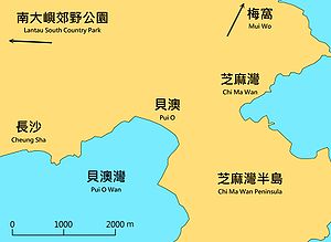
. It is a popular destination for holiday camping in Hong Kong. Visitors may also rent village houses for leisure. Located in the South Lantau, there are four main villages in Pui O, they are Lo Wai (老圍), San Wai (新圍), Lo Uk (羅屋), and Ham Tin (鹹田). Pui O is located at the edge of Lantau South Country Park
Lantau South Country Park
Lantau South Country Park is one of two rural parks on Lantau Island, the other one being Lantau North Country Park and its extension.Lantau South Country Park is located on the south side of the island. It was designated in 1978...
.
Geography

Sunset Peak
Sunset Peak or Tai Tung Shan is the third highest peak in Hong Kong. It is situated on Lantau Island within Lantau South Country Park and Lantau North Country Park and stands at a height of 869 m above the sea level. The second highest Lantau Peak is on the western part of the island....
. A main river from a valley to the east and other small river gather at Pui O forming an estuary
Estuary
An estuary is a partly enclosed coastal body of water with one or more rivers or streams flowing into it, and with a free connection to the open sea....
of wetland
Wetland
A wetland is an area of land whose soil is saturated with water either permanently or seasonally. Wetlands are categorised by their characteristic vegetation, which is adapted to these unique soil conditions....
. Villagers enclosed the wetland and converted it into rice paddies. This is indicated by the name Ham Tin (鹹田), salty paddy field
Paddy field
A paddy field is a flooded parcel of arable land used for growing rice and other semiaquatic crops. Paddy fields are a typical feature of rice farming in east, south and southeast Asia. Paddies can be built into steep hillsides as terraces and adjacent to depressed or steeply sloped features such...
. At the shore, a long beach (or spit
Spit (landform)
A spit or sandspit is a deposition landform found off coasts. At one end, spits connect to land, and extend into the sea. A spit is a type of bar or beach that develops where a re-entrant occurs, such as at cove's headlands, by the process of longshore drift...
) is formed by the interaction between the current of the South China Sea
South China Sea
The South China Sea is a marginal sea that is part of the Pacific Ocean, encompassing an area from the Singapore and Malacca Straits to the Strait of Taiwan of around...
and the rivers.
Pui O Beach
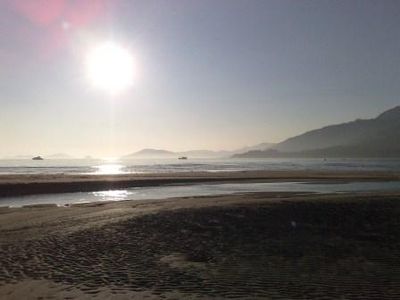
Pui O Beach (貝澳泳灘) runs along almost the entire shoreline of Pui O. Due to the geological composition of surrounding area, the sand on the beach is mixture of black and yellow. The Hong Kong Government has constructed facilities on the upper beach for wild camping.History
During the Qing DynastyQing Dynasty
The Qing Dynasty was the last dynasty of China, ruling from 1644 to 1912 with a brief, abortive restoration in 1917. It was preceded by the Ming Dynasty and followed by the Republic of China....
, villages near the shore in Hong Kong were frequently attacked by pirates. Villages in Pui O were constructed as walled villages
Walled villages of Hong Kong
Once common throughout China, walled villages can still be found in southern China and Hong Kong. Most of the walled villages in Hong Kong are located in the New Territories...
to assist in repelling these attacks, and several of the Lantau villages, though getting a living from the sea, were by design located at some distance from it.
Historical buildings

Antiquities and Monuments Office
Antiquities and Monuments Office was established when the Antiquities and Monuments Ordinance was enacted in 1976, to preserve Hong Kong's monuments under appropriate protection....
.
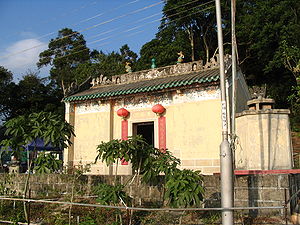
In Ham Tin, at Chung Hau (涌口) (the river mouth) there is a Tin Hau Temple
Tin Hau temples in Hong Kong
Over 70 temples are dedicated to Tin Hau in Hong Kong. They include:* Tin Hau temple, located at 10 Tin Hau Temple Road, Causeway Bay, east of Victoria Park, in Eastern District, on Hong Kong Island. It is a declared monument. The temple has given its name to the MTR station serving it .* The Tin...
. It was built in the Ming Dynasty
Ming Dynasty
The Ming Dynasty, also Empire of the Great Ming, was the ruling dynasty of China from 1368 to 1644, following the collapse of the Mongol-led Yuan Dynasty. The Ming, "one of the greatest eras of orderly government and social stability in human history", was the last dynasty in China ruled by ethnic...
, rebuilt in 1798 and repaired in 1947, 1974 and 1995. It is surrounded by two feng shui
Feng shui
Feng shui ' is a Chinese system of geomancy believed to use the laws of both Heaven and Earth to help one improve life by receiving positive qi. The original designation for the discipline is Kan Yu ....
trees, and an earth god shrine is located at its right side.
Other historical buildings include:
- Lin Kong Tong in Ham Tin, probably built in the late Qing Dynasty, it serves the dual-purpose of ancestral hall and meeting place to the elder branch of the Cheungs who settled in the village in the early 19th century.
- Cheung Ancestral Hall, also known as Yue Tak Tong, in Lo Wai, probably built in the late Qing Dynasty.
- Wing On Bridge and its associated earth god shrine in Ham Tin.
- An archeological site was discovered in Pui O in 1957.
Flora and fauna
MangroveMangrove
Mangroves are various kinds of trees up to medium height and shrubs that grow in saline coastal sediment habitats in the tropics and subtropics – mainly between latitudes N and S...
can be found on both sides of the estuary between Ham Tin and Pui O beach.
A resident population of water buffalo
Water buffalo
The water buffalo is a domesticated bovid widely kept in Asia, Europe and South America.Water buffalo can also refer to:*Wild water buffalo , the wild ancestor of the domestic water buffalo...
es can be found in Pui O. It is one of the few remaining areas where they still occur in Hong Kong.
Transport
Pui O is on the South Lantau RoadSouth Lantau Road
South Lantau Road is a road on the southern side of Lantau Island in Hong Kong. Being the major road on the island, the road connects Mui Wo in the east to Shek Pik in the west. Majority portion of the road is along the southern shore of the island...
. All bus routes between Mui Wo
Mui Wo
Mui Wo is a rural town on the eastern coast of Lantau Island in Hong Kong. The main beach in Mui Wo is known as Silver Mine Bay .-History:...
and other points pass through Pui O. A branch road, Chi Ma Wan Road routes across Chi Ma Wan Peninsula to Chi Ma Wan
Chi Ma Wan
Chi Ma Wan is a bay on southeastern Lantau Island, New Territories, Hong Kong. Chi Ma Wan Peninsula is where Chi Ma Wan, as well as Cheung Sha Wan, Tai Long Wan, Yi Long Wan and Mong Tung Wan are located...
.
Hiking Trails
The Lantau TrailLantau Trail
The Lantau Trail , opened on 4 December, 1984, is a long-distance footpath on Lantau Island in the New Territories of Hong Kong. The 70 km trail is circular, starting and finishing in Mui Wo. The Lantau Trail has good visitor facilities along the way, and the route is well marked. There are...
passes through Pui O, and there are many other hiking routes in the vicinity.

