

Puddingstone Park
Encyclopedia
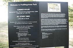
Park
A park is a protected area, in its natural or semi-natural state, or planted, and set aside for human recreation and enjoyment, or for the protection of wildlife or natural habitats. It may consist of rocks, soil, water, flora and fauna and grass areas. Many parks are legally protected by...
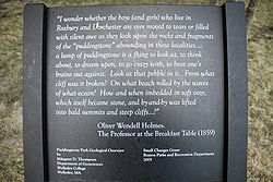
built as part of the redevelopment of the "ledge site", a former Puddingstone quarry
Quarry
A quarry is a type of open-pit mine from which rock or minerals are extracted. Quarries are generally used for extracting building materials, such as dimension stone, construction aggregate, riprap, sand, and gravel. They are often collocated with concrete and asphalt plants due to the requirement...
near the corner of Huntington Avenue and Tremont Street
Tremont Street
Tremont Street is a major thoroughfare in Boston, Massachusetts.-Etymology:The name is a variation of one of the original appellations of the city, "Trimountaine," a reference to a hill that formerly had three peaks. Beacon Hill, with its single peak, is all that remains of the Trimountain...
, at the Green Line trolley stop of Brigham Circle
Brigham Circle (MBTA station)
Brigham Circle is a trolley-train stop on the "E" branch of the MBTA's Green Line in Boston, MA. Along with the Longwood Station, it is the closest stop to Harvard Medical School, the Harvard School of Public Health and the rest of the Longwood Medical and Academic Area, all of which are within a...
, in the Mission Hill
Mission Hill, Boston, Massachusetts
Mission Hill is a 3/4 square mile neighborhood of Boston, with the population of approximately 18,000 people.The neighborhood is roughly bounded by Columbus Avenue and the Boston neighborhood of Roxbury to the east, Longwood Avenue to the northeast and the Olmsted designed Riverway/Jamaicaway and...
neighborhood of Boston, Massachusetts
Massachusetts
The Commonwealth of Massachusetts is a state in the New England region of the northeastern United States of America. It is bordered by Rhode Island and Connecticut to the south, New York to the west, and Vermont and New Hampshire to the north; at its east lies the Atlantic Ocean. As of the 2010...
. It is accessible from a stairway leading to an outdoor consumer parking lot, which has an entrance to the West, with a winding pathway leading upwards to a view of greater Boston.
A view of Mission Hill Church's towers is available. Nearby are the Farragut Elementary School
David Farragut School, Boston, Massachusetts
The David G. Farragut School, also known as The Farragut School, is located at 10 Fenwood Road, in the Mission Hill district of Boston, Massachusetts, just off of Huntington Avenue. The school is one of 86 elementary schools in the Boston School District. The school is near the Brigham Circle...
and Boston Latin School
Boston Latin School
The Boston Latin School is a public exam school founded on April 23, 1635, in Boston, Massachusetts. It is both the first public school and oldest existing school in the United States....
.
External links
- "Mission Hill NHS on Puddingstone Park"
- "Puddingstone Park: Reviews"
- "Puddingstone Park in Mission Hill Rededicated the Kevin W. Fitzgerald Park"