

Pratinha
Encyclopedia
Minas Gerais
Minas Gerais is one of the 26 states of Brazil, of which it is the second most populous, the third richest, and the fourth largest in area. Minas Gerais is the Brazilian state with the largest number of Presidents of Brazil, the current one, Dilma Rousseff, being one of them. The capital is the...
. Its population as of 2007 was 3,236 people living in a total area of 619 km². The city belongs to the meso-region of Triângulo Mineiro and Alto Paranaíba and to the micro-region of Araxá. It became a municipality in 1949.
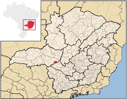
Location
Pratinha is located at an elevation of 1,162 (city center) meters, east of UberabaUberaba
Uberaba is a city and municipality in the west of the state of Minas Gerais in Brazil. Its population is 296.000 with an area of 4529.7 km², giving a density of 60.71 people per km². It is located on a plateau at an elevation of 785 meters and is in the Uberaba River floodplain...
. Neighboring municipalities are: Ibiá
Ibiá
Ibiá is a Brazilian municipality located in the west of the state of Minas Gerais. Its population as of 2007 was estimated to be 22,069 people living in a total area of 2,707 km². The city belongs to the mesoregion of Triângulo Mineiro and Alto Paranaíba and to the micro-region of Araxá...
(N), Campos Altos
Campos Altos
Campos Altos is a Brazilian municipality located in the west of the state of Minas Gerais. Its population as of 2007 was estimated to be 13,184 people living in a total area of 719 km². The city belongs to the mesoregion of Triângulo Mineiro and Alto Paranaíba and to the micro-region of Araxá. It...
(E), Medeiros
Medeiros
Medeiros is a common surname in the Portuguese language, namely in Portugal and Brazil, meaning maize stacks.It may refer to:-Persons:*Elli Medeiros, Uruguayan singer and actress*Glenn Medeiros, American singer and songwriter...
(SE), Tapira (SW), Araxá
Araxá
Araxá is a city and municipality in southwest Minas Gerais state, Brazil. The population was 87,764 inhabitants and the area of the municipality is 1,283 km², with 345 km² making up the urban perimeter.-Geography:...
(W).
Communications and Distances
Pratinha is connected to both AraxáAraxá
Araxá is a city and municipality in southwest Minas Gerais state, Brazil. The population was 87,764 inhabitants and the area of the municipality is 1,283 km², with 345 km² making up the urban perimeter.-Geography:...
and Uberlândia
Uberlândia
Uberlândia is the main town in the Triangle region, west of the state of Minas Gerais, Brazil. With a population of 604,013 inhabitants, according to 2010 estimates, the city is the second largest in the state second only to Belo Horizonte...
by national highway BR-462, which lies 19 km. on MG-796 to the north. The distance to Araxá
Araxá
Araxá is a city and municipality in southwest Minas Gerais state, Brazil. The population was 87,764 inhabitants and the area of the municipality is 1,283 km², with 345 km² making up the urban perimeter.-Geography:...
is 78 kilometers; Campos Altos
Campos Altos
Campos Altos is a Brazilian municipality located in the west of the state of Minas Gerais. Its population as of 2007 was estimated to be 13,184 people living in a total area of 719 km². The city belongs to the mesoregion of Triângulo Mineiro and Alto Paranaíba and to the micro-region of Araxá. It...
is 29 km to the northeast; Medeiros
Medeiros
Medeiros is a common surname in the Portuguese language, namely in Portugal and Brazil, meaning maize stacks.It may refer to:-Persons:*Elli Medeiros, Uruguayan singer and actress*Glenn Medeiros, American singer and songwriter...
is 27 km to the southeast; Uberaba
Uberaba
Uberaba is a city and municipality in the west of the state of Minas Gerais in Brazil. Its population is 296.000 with an area of 4529.7 km², giving a density of 60.71 people per km². It is located on a plateau at an elevation of 785 meters and is in the Uberaba River floodplain...
is 200 km. to the west; The distance to the state capital, Belo Horizonte
Belo Horizonte
Belo Horizonte is the capital of and largest city in the state of Minas Gerais, located in the southeastern region of Brazil. It is the third largest metropolitan area in the country...
, is 350 km.
Climate
Pratinha is one of the highest municipalities in Brazil. The climate is predominately tropical with rains in the summer and dry winters. The average annual rainfall is 1,574.7mm. The average annual temperature is 20.4°C, with an average maximum of 26.5°C and an average minimum of 15.7°C.Economic activities
The GDP in 2005 was approximately R$33 million, with 1 million reais from taxes, 10 million reais from services, 1 million reais from industry, and 20 million reais from agriculture. There were 554 rural producers on 44,000 hectares of land. The high elevation means the land is suitable for coffee growing. 117 farms had tractors (2006). Approximately 1,400 persons were dependent on agriculture. The main crops are coffee, rice, soybeans, beans, and corn. There were 22,000 head of cattle (2006), most of which were raised for milk and cheese production.There were no banks (2007) and 551 automobiles (2007), giving a ratio of 6 inhabitants per automobile.
Health and education
In the health sector there was 1 public health clinic (2005). Patients with more serious health conditions are transported to Araxá or to Uberlândia, which are connected by good roads. Educational needs were met by 3 primary schools, 1 middle school, and 1 pre-primary school.- Municipal Human Development IndexHuman Development IndexThe Human Development Index is a composite statistic used to rank countries by level of "human development" and separate "very high human development", "high human development", "medium human development", and "low human development" countries...
: 0.774 (2000) - State ranking: 146 out of 853 municipalities as of 2000
- National ranking: 1,229 out of 5,138 municipalities as of 2000
- Literacy rate: 84%
- Life expectancy: 74 (average of males and females)
In 2000 the per capita monthly income of R$246.00 was just below the state and national average of R$276.00 and R$297.00 respectively.
The highest ranking municipality in Minas Gerais in 2000 was Poços de Caldas
Poços de Caldas
Poços de Caldas is a city and municipality in south-western Minas Gerais state, Brazil, in the microregion of the same name. Its estimated population in 2009 was 151,449 inhabitants...
with 0.841, while the lowest was Setubinha
Setubinha
Setubinha is a municipality in the northeast of the Brazilian state of Minas Gerais. As of 2007 the population was 10,834 in a total area of 536 km². The elevation is 729 metres. It is part of the IBGE statistical microregion of Teófilo Otoni...
with 0.568. Nationally the highest was São Caetano do Sul
São Caetano do Sul
São Caetano do Sul is a city in São Paulo state in Brazil, located in the Greater São Paulo Metropolitan Area. It is the city with the highest per capita income in Brazil and it also has the highest Human Development Index .-Geography:São Caetano do Sul is located on a plateau that is part of the...
in São Paulo with 0.919, while the lowest was Setubinha. In more recent statistics (considering 5,507 municipalities) Manari in the state of Pernambuco
Pernambuco
Pernambuco is a state of Brazil, located in the Northeast region of the country. To the north are the states of Paraíba and Ceará, to the west is Piauí, to the south are Alagoas and Bahia, and to the east is the Atlantic Ocean. There are about of beaches, some of the most beautiful in the...
has the lowest rating in the country—0,467—putting it in last place.