

Postal codes in Portugal
Encyclopedia
The Portuguese
postal code
(código postal) is formed by four digits, a hyphen, then three digits, followed by a postal location of up to 25 characters in capitals. This location is the name of the town, sometimes followed by a three-letter abbreviation of the municipality (e.g. 4455-111 Paradela VNB)
Postal codes are given at the building block level and also to designated addresses with high volumes of mail.
The first digit designates one of nine postal regions; the following two digits designate postal distribution centers; the fourth digit is 0 if it belongs to a capital of municipality, 5 if not, or any other digit if it is a designated address; the last three digits sort building blocks and designated addresses. The more important the city, the more rounded is the number formed by the first four digits.
 Prior to 1976, only Lisbon
had used a system, of six zones (Lisboa 1 to Lisboa 6). In 1976, a national postal code system was introduced, with a four-digit structure, and designated addresses added "CODEX" (abbreviation of código extraordinário) to the postal location (example: 2001 SANTARÉM CODEX). In 1994, three extra digits were introduced and the "codex" expression was dropped.
Postal regions (first digit of postal code):
Note that, although the regions' names are connected the (extinct) 1936 provinces of Portugal
, their limits (with the exception of Algarve) are not exactly the same.
People can also search for postal codes at the CTT Correios website.
Portugal
Portugal , officially the Portuguese Republic is a country situated in southwestern Europe on the Iberian Peninsula. Portugal is the westernmost country of Europe, and is bordered by the Atlantic Ocean to the West and South and by Spain to the North and East. The Atlantic archipelagos of the...
postal code
Postal code
A postal code is a series of letters and/or digits appended to a postal address for the purpose of sorting mail. Once postal codes were introduced, other applications became possible.In February 2005, 117 of the 190 member countries of the Universal Postal Union had postal code systems...
(código postal) is formed by four digits, a hyphen, then three digits, followed by a postal location of up to 25 characters in capitals. This location is the name of the town, sometimes followed by a three-letter abbreviation of the municipality (e.g. 4455-111 Paradela VNB)
Postal codes are given at the building block level and also to designated addresses with high volumes of mail.
The first digit designates one of nine postal regions; the following two digits designate postal distribution centers; the fourth digit is 0 if it belongs to a capital of municipality, 5 if not, or any other digit if it is a designated address; the last three digits sort building blocks and designated addresses. The more important the city, the more rounded is the number formed by the first four digits.
Lisbon
Lisbon is the capital city and largest city of Portugal with a population of 545,245 within its administrative limits on a land area of . The urban area of Lisbon extends beyond the administrative city limits with a population of 3 million on an area of , making it the 9th most populous urban...
had used a system, of six zones (Lisboa 1 to Lisboa 6). In 1976, a national postal code system was introduced, with a four-digit structure, and designated addresses added "CODEX" (abbreviation of código extraordinário) to the postal location (example: 2001 SANTARÉM CODEX). In 1994, three extra digits were introduced and the "codex" expression was dropped.
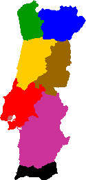
Postal regions (first digit of postal code):
- (pink) - City of Lisbon
- (red) - Estremadura e Ribatejo: Lisbon District (except City of Lisbon), Santarém District and parts of Leiria District and Setúbal District
- (yellow) - Beira Litoral: Coimbra and Aveiro districts and part of Leira and Viseu districts
- (green) - Minho e Douro Litoral: Viana do Castelo, Braga District and Porto DistrictPorto DistrictThe District of Porto , sometimes Oporto in English, is located on the north-west coast of Portugal. The district capital is the city of Porto, the second largest city in the country...
and part of Viseu and Vila Real Districts - (blue) - Trás-os-Montes e Alto Douro: Bragança District, most of Vila Real District and part of Viseu District and Guarda District
- (brown) - Beira Interior: Castelo Branco District and Guarda District and part of Portalegre District
- (violet) - Alentejo: Beja District and Évora District and parts of Portalegre District and Setúbal District
- (black) - Algarve: Faro District
- (not in map) - Madeira Islands and Azores
Note that, although the regions' names are connected the (extinct) 1936 provinces of Portugal
Provinces of Portugal
The Provinces of Portugal, although today not recognized in law and disused, continue to exist as socio-cultural divisions within the territory...
, their limits (with the exception of Algarve) are not exactly the same.
People can also search for postal codes at the CTT Correios website.