

Postage stamps and postal history of Zululand
Encyclopedia
Postal history
Postal history is the study of postal systems and how they operate and, or, the study of postage stamps and covers and associated material illustrating historical episodes of postal systems...
of Zululand under British
Great Britain
Great Britain or Britain is an island situated to the northwest of Continental Europe. It is the ninth largest island in the world, and the largest European island, as well as the largest of the British Isles...
rule.
The Zulu Kingdom
Zulu Kingdom
The Zulu Kingdom, sometimes referred to as the Zulu Empire or, rather imprecisely, Zululand, was a monarchy in Southern Africa that extended along the coast of the Indian Ocean from the Tugela River in the south to Pongola River in the north....
was defeated by Britain in the Anglo-Zulu War
Anglo-Zulu War
The Anglo-Zulu War was fought in 1879 between the British Empire and the Zulu Kingdom.Following the imperialist scheme by which Lord Carnarvon had successfully brought about federation in Canada, it was thought that a similar plan might succeed with the various African kingdoms, tribal areas and...
and was annexed as a British territory in 1887. For a brief period, it operated its own postal system and had its own postage stamps.
First post office
A post office was established in Eshowe in 1887, but an official postal system was not started until 1 May 1888, at which time both Zululand and neighboring NatalColony of Natal
The Colony of Natal was a British colony in south-eastern Africa. It was proclaimed a British colony on May 4, 1843 after the British government had annexed the Boer Republic of Natalia, and on 31 May 1910 combined with three other colonies to form the Union of South Africa, as one of its...
became members of the Universal Postal Union
Universal Postal Union
The Universal Postal Union is an international organization that coordinates postal policies among member nations, in addition to the worldwide postal system. The UPU contains four bodies consisting of the Congress, the Council of Administration , the Postal Operations Council and the...
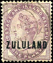
. At first, the territory used postage stamps of Great Britain and Natal overprint
Overprint
An overprint is an additional layer of text or graphics added to the face of a postage stamp or banknote after it has been printed. Post offices most often use overprints for internal administrative purposes such as accounting but they are also employed in public mail...
ed "ZULULAND".
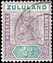
Key type stamps
A series of eight definitiveDefinitive stamp
A definitive stamp is a postage stamp, that is part of a regular issue of a country's stamps available for sale by the postal service for an extended period of time...
issues in the key plate
Key type stamp
Key type stamps are stamps of a uniform design that were widely used by colonial territories in the 19th and 20th centuries.- Origins :The idea was invented by Perkins Bacon who used it to print stamps for Trinidad , Barbados and Mauritius , all featuring the same Britannia design.- Key plate...
style with a profile of Queen Victoria
Victoria of the United Kingdom
Victoria was the monarch of the United Kingdom of Great Britain and Ireland from 20 June 1837 until her death. From 1 May 1876, she used the additional title of Empress of India....
, inscribed "ZULULAND" appeared in 1894 and were in use at 21 post offices. These stamps ranged in denomination from 1/2 penny to five pounds.
Annexation
Zululand was annexed by Natal in December 1897, and separate stamps were discontinued on 30 June 1898.Sources
- Stanley Gibbons Ltd: various catalogues
- Encyclopaedia of Postal History
- Rossiter, StuartStuart RossiterPercival "Stuart" Bryce Rossiter was a renowned British philatelist and postal historian who wrote extensively about British postal history and postage stamps of British colonies in Africa and was actively involved in numerous philatelic institutions...
& John Flower. The Stamp Atlas. London: Macdonald, 1986. ISBN 0356108627