

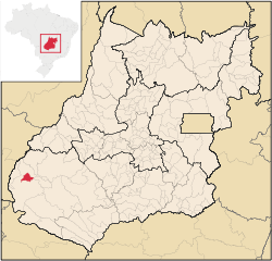
Portelândia
Encyclopedia
| Portelândia | |
|---|---|
| State | Goiás Goiás Goiás is a state of Brazil, located in the central part of the country. The name Goiás comes from the name of an indigenous community... |
| Area: | 552.4 km² |
| Population: | 3,310(IBGE 2007) |
| Elevation: | 858 |
| Postcode (CEP): | 75835-000 |
| IBGE statistical microregion: | 018 Sudoeste de Goiás |
| Became a city: | 1963 |
| Distance to Goiânia Goiânia -Climate:The city has a tropical wet and dry climate with an average temperature of . There's a wet season, from October to April, and a dry one, from May to September. Annual rainfall is around 1,520 mm.... : |
442 km. |
| Website: | n/a |
Town
A town is a human settlement larger than a village but smaller than a city. The size a settlement must be in order to be called a "town" varies considerably in different parts of the world, so that, for example, many American "small towns" seem to British people to be no more than villages, while...
and municipality
Municipality
A municipality is essentially an urban administrative division having corporate status and usually powers of self-government. It can also be used to mean the governing body of a municipality. A municipality is a general-purpose administrative subdivision, as opposed to a special-purpose district...
in southwestern Goiás
Goiás
Goiás is a state of Brazil, located in the central part of the country. The name Goiás comes from the name of an indigenous community...
state, Brazil
Brazil
Brazil , officially the Federative Republic of Brazil , is the largest country in South America. It is the world's fifth largest country, both by geographical area and by population with over 192 million people...
. It is a prosperous community with a large production of soybeans.
Geographical information
Portelândia is located in the extreme west of the state, 65,5 kilometers east of the Araguaia RiverAraguaia River
The Araguaia River or, in Portuguese, Rio Araguaia is one of the major rivers of Brazil, and the principal tributary of the Tocantins. It has a total length of approximately 2,627 km. Araguaia means "river of macaws" in the Tupi language....
and the boundary with the state of Mato Grosso
Mato Grosso
Mato Grosso is one of the states of Brazil, the third largest in area, located in the western part of the country.Neighboring states are Rondônia, Amazonas, Pará, Tocantins, Goiás and Mato Grosso do Sul. It also borders Bolivia to the southwest...
. The region is south of the Serra do Caiapó.
The distance to the state capital, Goiânia
Goiânia
-Climate:The city has a tropical wet and dry climate with an average temperature of . There's a wet season, from October to April, and a dry one, from May to September. Annual rainfall is around 1,520 mm....
, is 454 km. Highway connections are made by BR-060 / Abadia de Goiás
Abadia de Goiás
Abadia de Goiás is a small town and municipality in central Goiás state, Brazil, located on the western edge of the Goiânia metropolitan area.-Geographical Data:The distance to Goiânia is 27 km...
/ Guapó
Guapó
Guapó is a small town and municipality in central Goiás state, Brazil. The population was 13,586 and the total area of the municipality was 517.0 km² .Guapó is part of the Goiânia Microregion...
/ Indiara
Indiara
Indiara is a small city and municipality in central-south Goiás state, Brazil. Indiara is a large producer of soybeans and cotton.-Location:Indiara is located in the Vale do Rio dos Bois and has municipal boundaries with:*north: Palmeiras de Goiás...
/ Acreúna
Acreúna
Acreúna is a small city and municipality in western Goiás state, Brazil.-Location:Acreúna is located in the statistical micro-region of Vale do Rio dos Bois, southwest of the state capital, Goiânia, on BR-060, which links Goiânia with Rio Verde...
/ Rio Verde
Rio Verde, Goiás
Rio Verde is a city and municipality in the Brazilian state of Goiás. It is a fast-growing center and is the largest producer of grains in the state.-Location:...
/ BR-364 / Jataí
Jataí
Jataí is a municipality in southern Goiás state, Brazil. Its population was 88,048 in a total area of 7,174.2 km². Jataí is a major producer of agricultural products, including soybeans, rice, and corn. It has the largest herd of cattle in the state and is a large producer of poultry and...
/ Mineiros
Mineiros
Mineiros is a city in the southwest of the state of Goiás, Brazil. Mineiros is the westernmost city in Goiás and a great producer of cattle, soybeans, and corn....
/ GO-194. Sepin
Municipal boundaries are with Mineiros
Mineiros
Mineiros is a city in the southwest of the state of Goiás, Brazil. Mineiros is the westernmost city in Goiás and a great producer of cattle, soybeans, and corn....
, which surrounds it on all sides.
History
Before 1933 the area where Portelândia now lies was almost inhabited with a few cattle ranches. It belonged to the municipality of JataíJataí
Jataí is a municipality in southern Goiás state, Brazil. Its population was 88,048 in a total area of 7,174.2 km². Jataí is a major producer of agricultural products, including soybeans, rice, and corn. It has the largest herd of cattle in the state and is a large producer of poultry and...
. In 1933 Ludugerio Martins de Souza arrived with his wife and 8 children and built a residence on the banks of the Córrego da Porteira in lands belonging to the Fazenda Flores. Here Ludugerio set up a brick kiln to sell bricks to the local ranchers. Soon Walfredo Ivo de Oliveira saw the possibilities of starting a settlement in the area and he built the first solid building as a general store to sell to the passing muleteers. He began to buy land and the settlement began to grow. It was called Córrego da Porteira, after the stream. In 1938 it became part of Mineiros
Mineiros
Mineiros is a city in the southwest of the state of Goiás, Brazil. Mineiros is the westernmost city in Goiás and a great producer of cattle, soybeans, and corn....
. In 1948 the first school was built, followed by a church in 1954. In 1956 a highway BR-31 reached the town and lots were sold to new settlers. In 1963 Portelândia became a municipality, the name having its origin int Porteira, the name of the stream passing nearby.
Political and Demographic information
- Mayor: Valdineis Carrijo Rodrigues (January 2005)
- Eligible voters: 2,884 (2007)
- City council: 9 members
- Population density: 6.0 inhab/km² (2007)
- Urban population: 2,715(2007)
- Rural population: 595 (2007)
- Geometric population increase: -1.56%
Economic information
The economy is based on agriculture, cattle raising, services, public administration, and small transformation industries.- Industrial units: 4 (2007), employing 35 people in 2005
- Commercial units: 39 (2007), employing 147 people in 2005
- Bank agencies: Banco do Brasil S.A (June 2007)
- Dairies: - Portelat Ind. e Com. de Laticínios Ltda. - Marques Dourado Indústria e Comércio Ltda (22/05/2006)
- Motor vehicles: 219 automobiles (2007)
- Cattle herd: 21,500 head (2006)
- Dairy cows: 4,500 (2006)
- Main crops (2006): cotton, rice, sunflowers, soybeans (24,300 hectares), sorghum (2,000 hectares), and corn (3,800 hectares).
Education (2006)
- Schools: 4 with 1,326 students
- Middle school enrollment: 170 students
- Higher education: none
- Adult literacy rate: 86.3% (2000) (national average was 86.4%)
Health (2007)
- Hospitals: 1
- Hospital beds: 22
- Ambulatory clinics: 2
- Doctors, nurses, dentists: 7, 2, 1 (2002)
- Infant mortality rate: 12.1 (2000) (national average was 33.0).
Municipal Human Development Index
Human Development Index
The Human Development Index is a composite statistic used to rank countries by level of "human development" and separate "very high human development", "high human development", "medium human development", and "low human development" countries...
- MHDI: 0.790
- Ranking in the state: 29 out of 242 municipalities
- National ranking: 1044 out of 5507 municipalities
Data are from 2000
For the complete list see Frigoletto.com
See also
- List of municipalities in Goiás
- Microregions of Goiás