
Porcher Island
Encyclopedia
Porcher Island is an island in Hecate Strait
, British Columbia
, Canada, near the mouth of the Skeena River
and southwest of the port city of Prince Rupert
.
. The island’s northern tip is
24 km (14.9 mi) southwest of the port city of Prince Rupert
, and
70 km (43.5 mi) due south of the southernmost extension of the Alaska Panhandle
. The island is located within the Range 5 Coast Land District and the Skeena-Queen Charlotte Regional District
.
The island, together with some of its surrounding area, had a population of 37 in the Canada 2006 Census
, down 26% from the 2001 census
.
Porcher Island is bounded on the north by Chatham Sound and the Skeena River
estuary, by Hecate Strait
to the west and by Ogden Channel to the east. Metlakata Inlet and Kitkatla Channel separate Porcher’s southern flank from the Goschen, Dolphin and Spicer Islands, near the entrance to Principe Channel. Kitkatla
(Laxklan), a Tsimshian
village, is situated on Dolphin Island
.
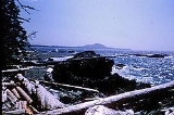
Porcher Island is nearly bisected from the south by Porcher Inlet, a long, narrow channel that intrudes
13.7 km (8.5 mi) into the island’s interior, before emptying into a salt lagoon at the foot of the Spiller Range. Oval Bay, on the island’s western edge, features a 5 km (3.1 mi) sandy beach, which is exposed to the ferocious southeast gales that regularly sweep through Hecate Strait.
(1821–1878), who served as Commander of HMS Sparrowhawk at Esquimalt Naval Base
, Vancouver Island, from the spring of 1865 until he returned to England in the fall of 1868. While serving with the North Pacific Squadron
, Commander Porcher made four summertime voyages to the North Coast of British Columbia
; in 1866, 1867 and twice in 1868. The route of the Inside Passage
that the Sparrowhawk took from Esquimalt to the Hudson’s Bay Company trading post at Fort Simpson
(the Tsimshian
village of Lax Kw'alaams) would have passed close by the island in Chatham Sound that now bears the Commander’s name.
HMS Sparrowhawk
was launched in March, 1856 at Limehouse
, England and served at various stations in the Far East
. By the spring of 1865, she was a converted, three-masted barque
of the Wanderer Class, equipped for sail or steam. The 200-foot vessel carried five guns and a complement of 90 officers and men. She was sold in 1872 and was eventually lost in a typhoon. Porcher Island was named by Captain Daniel Pender
in 1867.
With the exception of a brief influx of homesteaders in the wake of Prince Rupert being chosen as the terminus of the Grand Trunk Pacific Railway
in 1906, Porcher Island has always been sparsely populated. The island’s relative isolation, combined with wet, cool summers and severe winters, has discouraged many of those who sought to make Porcher Island their permanent home. Nonetheless, three small settlements that were established during the 20th century still boast a few inhabitants today. These settlements are to be found at Hunts Inlet (formerly Jap Inlet) and at Humpback Bay, both on the island’s northernmost tip, and at Oona River, which flows into Ogden Channel at the island’s eastern edge.
Hunts Inlet is a collection of older buildings grouped around a government dock, with the more recent addition of a number of vacation homes built by Prince Rupert residents.
 Humpback Bay is the site of the former Porcher Island Cannery, now derelict. The salmon cannery was originally built by the Chatham Sound Fishing and Packing Company in 1928, but operated for only four years before closing at the end of the 1932 salmon season. The site was later purchased by the Canadian Fishing Company and used as a summer gillnet
station until 1968, when gillnet operations were transferred to North Pacific Cannery. Humpback Bay continued to serve as a net storage facility until the 1980s, when the Crown lease was sold to private interests.
With 30 or so permanent residents, Oona River currently has the largest population of the three surviving Porcher Island settlements. Situated at the northern end of Ogden Channel, Oona River was originally settled by Scandinavian immigrants in the years before and after the First World War. The village has long been a source of wooden boats for the B.C. salmon fishing industry. Scores of these sturdy, seaworthy vessels were hand-built from red and yellow cedar by early settlers and their descendants, and some can still be seen in use today. The Oona River Salmon Enhancement Project, first established some 25 years ago, continues to rebuild threatened coho salmon stocks in the Porcher Island area.
in the north to Queen Charlotte Strait
in the south. Hecate Lowland terrain is generally rough and rocky, with wide areas of muskeg wetland and bog forest. Tree species include western red cedar, yellow cedar, mountain hemlock and fir. Salal, ferns, berry bush and skunk cabbage are commonly found undergrowth. Lowland climate in the Porcher Island region is dominated by frontal flows from Dixon Entrance
, resulting in frequent wind storms and heavy rainfall. Waterfowl are found in abundance throughout the protected inlets and estuaries that notch Porcher Island’s 100 mile coastline. Species include murre, grebe, murrelet, gull, tern, loon, auklet, petrel and eagle. Both Chatham Sound and Kitkatla Channel afford a profusion of breeding and nesting habitat for a wide variety of seabirds, and are essential components of the Pacific coast migratory flyway.
Hecate Strait
Hecate Strait is a wide but shallow strait between the Haida Gwaii and the mainland of British Columbia, Canada. It merges with Queen Charlotte Sound to the south and Dixon Entrance to the north...
, British Columbia
British Columbia
British Columbia is the westernmost of Canada's provinces and is known for its natural beauty, as reflected in its Latin motto, Splendor sine occasu . Its name was chosen by Queen Victoria in 1858...
, Canada, near the mouth of the Skeena River
Skeena River
The Skeena River is the second longest river entirely within British Columbia, Canada . The Skeena is an important transportation artery, particularly for the Tsimshian and the Gitxsan - whose names mean "inside the Skeena River" and "people of the Skeena River" respectively, and also during the...
and southwest of the port city of Prince Rupert
Prince Rupert, British Columbia
Prince Rupert is a port city in the province of British Columbia, Canada. It is the land, air, and water transportation hub of British Columbia's North Coast, and home to some 12,815 people .-History:...
.
Geography
With a land area of 200 sq mi (518 km²), Porcher Island is the eighth largest coastal island in British ColumbiaBritish Columbia
British Columbia is the westernmost of Canada's provinces and is known for its natural beauty, as reflected in its Latin motto, Splendor sine occasu . Its name was chosen by Queen Victoria in 1858...
. The island’s northern tip is
24 km (14.9 mi) southwest of the port city of Prince Rupert
Prince Rupert, British Columbia
Prince Rupert is a port city in the province of British Columbia, Canada. It is the land, air, and water transportation hub of British Columbia's North Coast, and home to some 12,815 people .-History:...
, and
70 km (43.5 mi) due south of the southernmost extension of the Alaska Panhandle
Alaska Panhandle
Southeast Alaska, sometimes referred to as the Alaska Panhandle, is the southeastern portion of the U.S. state of Alaska, which lies west of the northern half of the Canadian province of British Columbia. The majority of Southeast Alaska's area is part of the Tongass National Forest, the United...
. The island is located within the Range 5 Coast Land District and the Skeena-Queen Charlotte Regional District
Skeena-Queen Charlotte Regional District, British Columbia
The Skeena-Queen Charlotte Regional District is a quasi-municipal administrative area in British Columbia. It is located on British Columbia's west coast and includes Haida Gwaii , the largest of which are Graham Island and Moresby Island...
.
The island, together with some of its surrounding area, had a population of 37 in the Canada 2006 Census
Canada 2006 Census
The Canada 2006 Census was a detailed enumeration of the Canadian population. Census day was May 16, 2006. The next census following will be the 2011 Census. Canada's total population enumerated by the 2006 census was 31,612,897...
, down 26% from the 2001 census
Canada 2001 Census
The Canada 2001 Census was a detailed enumeration of the Canadian population. Census day was May 15, 2001. On that day, Statistics Canada attempted to count every person in Canada. The total population count of Canada was 30,007,094. This was a 4% increase over 1996 Census of 28,846,761. In...
.
Porcher Island is bounded on the north by Chatham Sound and the Skeena River
Skeena River
The Skeena River is the second longest river entirely within British Columbia, Canada . The Skeena is an important transportation artery, particularly for the Tsimshian and the Gitxsan - whose names mean "inside the Skeena River" and "people of the Skeena River" respectively, and also during the...
estuary, by Hecate Strait
Hecate Strait
Hecate Strait is a wide but shallow strait between the Haida Gwaii and the mainland of British Columbia, Canada. It merges with Queen Charlotte Sound to the south and Dixon Entrance to the north...
to the west and by Ogden Channel to the east. Metlakata Inlet and Kitkatla Channel separate Porcher’s southern flank from the Goschen, Dolphin and Spicer Islands, near the entrance to Principe Channel. Kitkatla
Kitkatla
The Kitkatla are one of the 14 bands of the Tsimshian nation of the Canadian province of British Columbia, and inhabit a village, also called Kitkatla , on Dolphin Island, a small island just by Porcher Island off the coast of northern B.C. Because of this they have sometimes been called Porcher...
(Laxklan), a Tsimshian
Tsimshian
The Tsimshian are an indigenous people of the Pacific Northwest Coast. Tsimshian translates to Inside the Skeena River. Their communities are in British Columbia and Alaska, around Terrace and Prince Rupert and the southernmost corner of Alaska on Annette Island. There are approximately 10,000...
village, is situated on Dolphin Island
Dolphin Island
Dolphin Island: A Story of the People of the Sea is a novel by Arthur C. Clarke first published in 1963.-Summary:Late one night , a giant cargo hover ship makes an emergency landing somewhere in the middle of the United States and an enterprising teenager named Johnny Clinton stows away on it...
.
Porcher Island is nearly bisected from the south by Porcher Inlet, a long, narrow channel that intrudes
13.7 km (8.5 mi) into the island’s interior, before emptying into a salt lagoon at the foot of the Spiller Range. Oval Bay, on the island’s western edge, features a 5 km (3.1 mi) sandy beach, which is exposed to the ferocious southeast gales that regularly sweep through Hecate Strait.
History
Porcher Island is named after Edwin Augustus Porcher, RNRoyal Navy
The Royal Navy is the naval warfare service branch of the British Armed Forces. Founded in the 16th century, it is the oldest service branch and is known as the Senior Service...
(1821–1878), who served as Commander of HMS Sparrowhawk at Esquimalt Naval Base
CFB Esquimalt
Canadian Forces Base Esquimalt is Canada's Pacific Coast naval base and home port to Maritime Forces Pacific and Joint Task Force Pacific Headquarters....
, Vancouver Island, from the spring of 1865 until he returned to England in the fall of 1868. While serving with the North Pacific Squadron
Pacific Station
The Pacific Station, often referred to as the Pacific Squadron, was one of the geographical divisions into which the Royal Navy divided its worldwide responsibilities...
, Commander Porcher made four summertime voyages to the North Coast of British Columbia
British Columbia Coast
The British Columbia Coast or BC Coast is Canada's western continental coastline on the Pacific Ocean. The usage is synonymous with the term West Coast of Canada....
; in 1866, 1867 and twice in 1868. The route of the Inside Passage
Inside Passage
The Inside Passage is a coastal route for oceangoing vessels along a network of passages which weave through the islands on the Pacific coast of North America. The route extends from southeastern Alaska, in the United States, through western British Columbia, in Canada, to northwestern Washington...
that the Sparrowhawk took from Esquimalt to the Hudson’s Bay Company trading post at Fort Simpson
Fort Simpson (Columbia Department)
Fort Simpson was a fur trading post established in 1831 by the Hudson's Bay Company near the mouth of the Nass River in present-day British Columbia, Canada. In 1834 it was moved to the Tsimpsean Peninsula, about halfway between the Nass River and the Skeena River...
(the Tsimshian
Tsimshian
The Tsimshian are an indigenous people of the Pacific Northwest Coast. Tsimshian translates to Inside the Skeena River. Their communities are in British Columbia and Alaska, around Terrace and Prince Rupert and the southernmost corner of Alaska on Annette Island. There are approximately 10,000...
village of Lax Kw'alaams) would have passed close by the island in Chatham Sound that now bears the Commander’s name.
HMS Sparrowhawk
HMS Sparrowhawk (1856)
HMS Sparrowhawk was a Vigilant-class second-class despatch/gunvessel launched on 9 February 1856 at Limehouse, England and served at various stations in the Far East. By the spring of 1865, her rig was a converted to that of a three-masted barque. She was sold in 1872 and was eventually lost in a...
was launched in March, 1856 at Limehouse
Limehouse
Limehouse is a place in the London Borough of Tower Hamlets. It is on the northern bank of the River Thames opposite Rotherhithe and between Ratcliff to the west and Millwall to the east....
, England and served at various stations in the Far East
Far East
The Far East is an English term mostly describing East Asia and Southeast Asia, with South Asia sometimes also included for economic and cultural reasons.The term came into use in European geopolitical discourse in the 19th century,...
. By the spring of 1865, she was a converted, three-masted barque
Barque
A barque, barc, or bark is a type of sailing vessel with three or more masts.- History of the term :The word barque appears to have come from the Greek word baris, a term for an Egyptian boat. This entered Latin as barca, which gave rise to the Italian barca, Spanish barco, and the French barge and...
of the Wanderer Class, equipped for sail or steam. The 200-foot vessel carried five guns and a complement of 90 officers and men. She was sold in 1872 and was eventually lost in a typhoon. Porcher Island was named by Captain Daniel Pender
Daniel Pender
Daniel Pender was a Royal Navy Staff Commander, later Captain, who surveyed the Coast of British Columbia aboard HMS Plumper, HMS Hecate and the Beaver from 1857 to 1870.-Legacy:...
in 1867.
With the exception of a brief influx of homesteaders in the wake of Prince Rupert being chosen as the terminus of the Grand Trunk Pacific Railway
Grand Trunk Pacific Railway
The Grand Trunk Pacific Railway was a historical Canadian railway.A wholly owned subsidiary of the Grand Trunk Railway , the GTPR was constructed by GTR using loans provided by the Government of Canada. The company was formed in 1903 with a mandate to build west from Winnipeg, Manitoba to the...
in 1906, Porcher Island has always been sparsely populated. The island’s relative isolation, combined with wet, cool summers and severe winters, has discouraged many of those who sought to make Porcher Island their permanent home. Nonetheless, three small settlements that were established during the 20th century still boast a few inhabitants today. These settlements are to be found at Hunts Inlet (formerly Jap Inlet) and at Humpback Bay, both on the island’s northernmost tip, and at Oona River, which flows into Ogden Channel at the island’s eastern edge.
Hunts Inlet is a collection of older buildings grouped around a government dock, with the more recent addition of a number of vacation homes built by Prince Rupert residents.
Gillnet
Gillnetting is a common fishing method used by commercial and artisanal fishermen of all the oceans and in some freshwater and estuary areas. The gillnet also is used by fisheries scientists to monitor fish populations. Because gillnets can be so effective their use is closely monitored and...
station until 1968, when gillnet operations were transferred to North Pacific Cannery. Humpback Bay continued to serve as a net storage facility until the 1980s, when the Crown lease was sold to private interests.
With 30 or so permanent residents, Oona River currently has the largest population of the three surviving Porcher Island settlements. Situated at the northern end of Ogden Channel, Oona River was originally settled by Scandinavian immigrants in the years before and after the First World War. The village has long been a source of wooden boats for the B.C. salmon fishing industry. Scores of these sturdy, seaworthy vessels were hand-built from red and yellow cedar by early settlers and their descendants, and some can still be seen in use today. The Oona River Salmon Enhancement Project, first established some 25 years ago, continues to rebuild threatened coho salmon stocks in the Porcher Island area.
Ecology
Porcher Island is part of the Hecate Lowland Ecosection, a once heavily glaciated band of narrow lowland rain forest and coastal archipelago that stretches from Portland InletPortland Inlet
Portland Inlet is an inlet of the Pacific Ocean on the coast of British Columbia, Canada, approximately 55 kilometers north of Prince Rupert, British Columbia. It joins the Chatham Sound opposite the Dixon Entrance. It is 40 kilometers long and as much as 13 kilometers wide...
in the north to Queen Charlotte Strait
Queen Charlotte Strait
Queen Charlotte Strait is a strait between Vancouver Island and the mainland of British Columbia, Canada. It connects Queen Charlotte Sound with Johnstone Strait, Discovery Passage and then to the Strait of Georgia and Puget Sound...
in the south. Hecate Lowland terrain is generally rough and rocky, with wide areas of muskeg wetland and bog forest. Tree species include western red cedar, yellow cedar, mountain hemlock and fir. Salal, ferns, berry bush and skunk cabbage are commonly found undergrowth. Lowland climate in the Porcher Island region is dominated by frontal flows from Dixon Entrance
Dixon Entrance
The Dixon Entrance is a strait about long and wide in the Pacific Ocean at the International Boundary between the U.S. state of Alaska and the province of British Columbia in Canada. It was named by Joseph Banks for Captain George Dixon, a Royal Navy officer, fur trader, and explorer, who...
, resulting in frequent wind storms and heavy rainfall.