

Political divisions of Karafuto Prefecture
Encyclopedia
Between 1905 and 1945, the Japanese Empire administered the southern half of Sakhalin
, using the name . The area was designated a chō, the same term given to Hokkaidō
at the time. It is commonly referred to as Karafuto Prefecture
in English
. The prefecture was divided into 4 subprefectures
(shichō), which in turn were subdivided into 11 districts
, in turn divided into 41 municipalities
(1 city
, 13 towns
, and 27 villages
)
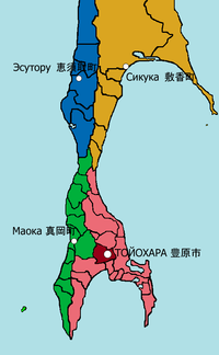 Prefectural capital: Toyohara
Notes
Sakhalin
Sakhalin or Saghalien, is a large island in the North Pacific, lying between 45°50' and 54°24' N.It is part of Russia, and is Russia's largest island, and is administered as part of Sakhalin Oblast...
, using the name . The area was designated a chō, the same term given to Hokkaidō
Hokkaido
, formerly known as Ezo, Yezo, Yeso, or Yesso, is Japan's second largest island; it is also the largest and northernmost of Japan's 47 prefectural-level subdivisions. The Tsugaru Strait separates Hokkaido from Honshu, although the two islands are connected by the underwater railway Seikan Tunnel...
at the time. It is commonly referred to as Karafuto Prefecture
Prefectures of Japan
The prefectures of Japan are the country's 47 subnational jurisdictions: one "metropolis" , Tokyo; one "circuit" , Hokkaidō; two urban prefectures , Osaka and Kyoto; and 43 other prefectures . In Japanese, they are commonly referred to as...
in English
English language
English is a West Germanic language that arose in the Anglo-Saxon kingdoms of England and spread into what was to become south-east Scotland under the influence of the Anglian medieval kingdom of Northumbria...
. The prefecture was divided into 4 subprefectures
Subprefectures of Japan
Certain prefectures of Japan are now, or once were, divided into subprefectures. The subprefecture is the jurisdiction surrounding a of the prefectural government. Normally, the area of a subprefecture consists of a few to a dozen cities, towns, and/or villages. Subprefectures are formed to...
(shichō), which in turn were subdivided into 11 districts
Districts of Japan
The was most recently used as an administrative unit in Japan between 1878 and 1921 and is roughly equivalent to the county of the United States, ranking at the level below prefecture and above city, town or village. As of 2008, cities belong directly to prefectures and are independent from...
, in turn divided into 41 municipalities
Municipalities of Japan
Japan has three levels of government: national, prefectural, and municipal. The nation is divided into 47 prefectures. Each prefecture consists of numerous municipalities. There are four types of municipalities in Japan: cities, towns, villages and special wards...
(1 city
Cities of Japan
||A is a local administrative unit in Japan. Cities are ranked on the same level as and , with the difference that they are not a component of...
, 13 towns
Towns of Japan
A town is a local administrative unit in Japan. It is a local public body along with prefecture , city , and village...
, and 27 villages
Villages of Japan
A is a local administrative unit in Japan.It is a local public body along with , , and . Geographically, a village's extent is contained within a prefecture....
)
List of municipalities of Karafuto Prefecture
Notes
- The data is as of 1945.
- Some municipalities had multiple possible readings. 敷香, for instance, was read Shikuka, Shisuka, or Shikika, depending on sources.
- All KanjiKanjiKanji are the adopted logographic Chinese characters hanzi that are used in the modern Japanese writing system along with hiragana , katakana , Indo Arabic numerals, and the occasional use of the Latin alphabet...
names are in ShinjitaiShinjitaiShinjitai are the forms of kanji used in Japan since the promulgation of the Tōyō Kanji List in 1946. Some of the new forms found in shinjitai are also found in simplified Chinese, but shinjitai is generally not as extensive in the scope of its modification...
, a modern form which was not used when the prefecture existed. - The list shows the current RussianRussian languageRussian is a Slavic language used primarily in Russia, Belarus, Uzbekistan, Kazakhstan, Tajikistan and Kyrgyzstan. It is an unofficial but widely spoken language in Ukraine, Moldova, Latvia, Turkmenistan and Estonia and, to a lesser extent, the other countries that were once constituent republics...
names in parenthesis. However, Russian divisionsAdministrative divisions of Sakhalin Oblast*Cities and towns under the oblast's jurisdiction:**Yuzhno-Sakhalinsk ***with 2 selsovets under the city's jurisdiction.**Alexandrovsk-Sakhalinsky **Dolinsk **Kholmsk...
do not match with Japanese divisions. These names just roughly overlap with central towns.
Toyohara Subprefecture 豊原支庁
Subprefectural capital: Toyohara- Ōtomari District, alternatively Ōdomari 大泊郡
- Chitose Village 千歳村 (Tret'ya Pad)
- Fukami Village 深海村 (Prigorodnoye)
- Nagahama Village 長浜村 (Ozyorskoye)
- Ōtomari Town, alternatively Ōdomari 大泊町 (KorsakovKorsakov (town)Korsakov is a town in Sakhalin Oblast, Russia. It is the administrative center of Korsakovsky District. Population: 35,079 ; The town is located some south from Yuzhno-Sakhalinsk, at the southern end of Sakhalin Island, on the coast of the Salmon Cove in the Aniva Bay.-History:Little is known...
) - Shiretoko Village 知床村 (Novikovo)
- Tōbuchi Village 遠淵村 (Murav'yovo)
- Tomuna Village 富内村 (Okhotskoye)
- Rūtaka District, alternatively Rutaka 留多加郡
- Notoro Village 能登呂村 (Kirillovo)
- Rūtaka Town, alternatively Rutaka 留多加町 (AnivaAnivaAniva is a coastal town in Sakhalin Oblast, Russia, located on the coast of Aniva Bay in southern Sakhalin on the Lyutoga River 37 km south of Yuzhno-Sakhalinsk. Population: 8,084 ; 8,905 .-History:...
) - Sango Village 三郷村 (Taranay)
- Toyohara City 豊原市 (Yuzhno-SakhalinskYuzhno-Sakhalinsk-Demographics:Most residents are ethnic Russians, but there also exists a sizable population of Koreans. Of the 43,000 Sakhalin Koreans, half are estimated to live in Yuzhno-Sakhalinsk, comprising roughly 12% of the city's population...
) - Toyosakae District 豊栄郡 (Vysokoye)
- Kawakami Village 川上村 (Sinegorsk)
- Ochiai Town 落合町 (DolinskDolinskDolinsk is a town in Sakhalin Oblast, Russia, the administrative center of Dolinsky District. In Japanese, it is known as Ochiai . Population: 12,555 ; 15,653 .-Geography:...
) - Sakaehama Village 栄浜村 (Starodubskoye)
- Shiranui Village 白縫村 (Vzmorye)
- Toyokita Village 豊北村 (Lugovoye)
Maoka Subprefecture 真岡支庁
Subprefectural capital: Maoka- Honto District 本斗郡
- Honto Town 本斗町 (NevelskNevelskNevelsk is a port town in Sakhalin Oblast, Russia. Population 18,639 .-Geography:The town is located on the southwest coast of Sakhalin, 123 km from Yuzhno-Sakhalinsk, on the Sea of Japan.-History:...
) - Kaiba Village 海馬村 (Moneron IslandMoneron IslandMoneron Island, is a Russian possession located off Sakhalin Island.-Description:Moneron has an area of about and a highest point of . It is approximately long by wide, and is located from Sakhalin's port of Nevelsk and about directly southwest of Sakhalin Island itself at the northeastern...
) - Kōni Village 好仁村 (Shebunino)
- Naihoro Town 内幌町 (Gornozavodsk)
- Honto Town 本斗町 (Nevelsk
- Maoka District 真岡郡
- Hirochi Village 広地村 (Pravda)
- Konotoro Village 小能登呂 (Kostromskoye)
- Maoka Town 真岡町 (KholmskKholmskKholmsk is a town in Sakhalin Oblast, Russia, the administrative center of Kholmsky District. Population: 35,141 .-History:The town was founded in 1870 as a military post. After the Russo-Japanese War of 1904-05, the town was transferred to Japanese control, along with the rest of southern...
) - Noda Town 野田町 (ChekhovoChekhovo, Sakhalin OblastChekhovo is a village in Sakhalin Oblast, Russia, at the Strait of Tartary. Population: 4,944 ; 7,901 .Before 1946 it was named Noda . It was granted town status and renamed Chekhov in 1947. It was demoted to village in 2004 , and changed its name to Chekhovo....
) - Randomari Village 蘭泊村 (Yablochny)
- Shimizu Village 清水村 (Chaplakovo)
- Tomarioru District 泊居郡
- Kushunnai Village 久春内村 (Ilyinsky)
- Nayori Village 名寄村 (Penzenskoye)
- Tomarioru Town 泊居町 (Tomari)
Esutoru Subprefecture 恵須取支庁
Subprefectural capital: Esutoru- Esutoru District 恵須取郡
- Chinnai Town 珍内町 (Krasnogorsk)
- Esutoru Town 恵須取町 (UglegorskUglegorsk, Sakhalin OblastUglegorsk is a coastal port town in Sakhalin Oblast, Russia, located on the western coast of Sakhalin 359 km west of Yuzhno-Sakhalinsk. Population: 13,396 ; 18,402 .-History:...
) - Tōro Town 塔路町 (Shakhtyorsk)
- Ushiro Village 鵜城村 (Orlovo)
- Nayoshi District 名好郡
- Nayoshi Town 名好町 (Lesogorsk)
- Nishisakutan Village 西柵丹村 (Boshnyakovo)
Shikuka Subprefecture 敷香支庁
Subprefectural capital: Shikuka- Motodomari District, alternatively Mototomari 元泊郡
- Hoyori Village 帆寄村 (Pugachevo)
- Motodomari Village, alternatively Mototomari 元泊村 (Vostochny)
- Shirutoru Town, alternatively Shiritori 知取町 (Makarov)
- Shikuka District, alternatively Shisuka or Shikika 敷香郡
- Chirie Village 散江村 (Kotikovo)
- Nairo Village 内路村 (Gastello)
- Shikuka Town, alternatively Shisuka or Shikika 敷香町 (PoronayskPoronayskPoronaysk is a town in Sakhalin Oblast, Russia, located on the Poronay River some 288 km north of Yuzhno-Sakhalinsk. It is the administrative center of Poronaysky District. Population: 17,400 ; 17,954 ; 25,971 ....
) - Tomarikishi Village 泊岸村 (Vakhrushev)