
Pirapó
Encyclopedia
| Map | |
|---|---|
 |
|
| Statistics | |
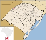
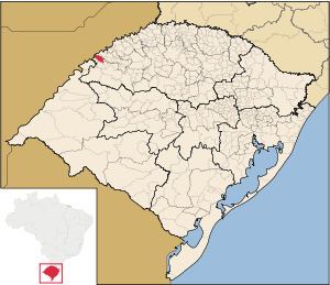
| State: | Rio Grande do Sul Rio Grande do Sul Rio Grande do Sul is the southernmost state in Brazil, and the state with the fifth highest Human Development Index in the country. In this state is located the southernmost city in the country, Chuí, on the border with Uruguay. In the region of Bento Gonçalves and Caxias do Sul, the largest wine... |
| Meso-region: | Northwestern Rio Grande do Sul (Noroeste Rio-Grandense) |
| Micro-Region: | Santo Ângelo Santo Ângelo (micro-region) The Santo Ângelo micro-region is a micro-region in the western part of the state of Rio Grande do Sul, Brazil... |
| Anniversary: | November 30, 1987 |
| Founded: | November 30, 1987 |
| Location Location (geography) The terms location and place in geography are used to identify a point or an area on the Earth's surface or elsewhere. The term 'location' generally implies a higher degree of can certainty than "place" which often has an ambiguous boundary relying more on human/social attributes of place identity... : |
28.0445/28° 2' 42" S lat. 55.299/55° 11' 56" W long. |
| Postal code: | 97885-xxx |
| Website: | www.pirapo.rs.gov.br |
| Politics | |
| Mayor Mayor In many countries, a Mayor is the highest ranking officer in the municipal government of a town or a large urban city.... : |
|
Pirapó is a municipality
Municipality
A municipality is essentially an urban administrative division having corporate status and usually powers of self-government. It can also be used to mean the governing body of a municipality. A municipality is a general-purpose administrative subdivision, as opposed to a special-purpose district...
of the western part of the state of Rio Grande do Sul
Rio Grande do Sul
Rio Grande do Sul is the southernmost state in Brazil, and the state with the fifth highest Human Development Index in the country. In this state is located the southernmost city in the country, Chuí, on the border with Uruguay. In the region of Bento Gonçalves and Caxias do Sul, the largest wine...
, Brazil
Brazil
Brazil , officially the Federative Republic of Brazil , is the largest country in South America. It is the world's fifth largest country, both by geographical area and by population with over 192 million people...
. The origin of the name comes from the Tupi language. It is located 563 km west of the state capital of Porto Alegre
Porto Alegre
Porto Alegre is the tenth most populous municipality in Brazil, with 1,409,939 inhabitants, and the centre of Brazil's fourth largest metropolitan area . It is also the capital city of the southernmost Brazilian state of Rio Grande do Sul. The city is the southernmost capital city of a Brazilian...
and northeast of Alegrete
Alegrete
Alegrete is a town and a municipality in Rio Grande do Sul located in southern Brazil. Its medium altitude is 102 m. Its estimated population in 2008 was 78,984 inhabitants and the total area is 7,803.967 km² . Its inhabitants are called Alegretenses.Alegrete was settled in 1816 and became a...
.
The river is situated by the Uruguay River
Uruguay River
The Uruguay River is a river in South America. It flows from north to south and makes boundary with Brazil, Argentina, and Uruguay, separating some of the Argentine provinces of the Mesopotamia from the other two countries...
and is bordered with Argentina
Argentina
Argentina , officially the Argentine Republic , is the second largest country in South America by land area, after Brazil. It is constituted as a federation of 23 provinces and an autonomous city, Buenos Aires...
to the west.
External links
- http://www.citybrazil.com.br/rs/pirapo/
- Map and Aerial photos:
- Coordinates: 28°2′42"S 54°11′56"W
- Street maps: Street map from Mapquest, MapPoint or Google
- Satellite images and Aerial photos: Google