

São Romão
Encyclopedia
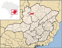
Minas Gerais
Minas Gerais is one of the 26 states of Brazil, of which it is the second most populous, the third richest, and the fourth largest in area. Minas Gerais is the Brazilian state with the largest number of Presidents of Brazil, the current one, Dilma Rousseff, being one of them. The capital is the...
. In 2007 the population was 9,080 in a total area of 2,432 km². It became a municipality in 1943.
Location and Distances
São Romão is located on the left bank of the São Francisco RiverSão Francisco River
The São Francisco is a river in Brazil. With a length of , it is the longest river that runs entirely in Brazilian territory, and the fourth longest in South America and overall in Brazil...
at an elevation of 480 meters. It is north of the nearest population center, Pirapora
Pirapora
Pirapora is a municipality in northcentral Minas Gerais in Brazil. Its population in 2007 was 51,636 in a total area of 577 km². The name Pirapora comes from the Tupi words for "fish" + "jump", referring to the piracema season when a mass migration of fishes ascends the São Francisco River...
. Montes Claros
Montes Claros
Montes Claros is a city located in northern Minas Gerais state, in Brazil. The estimated population in 2010 was 412,284 inhabitants and the total area of the municipality was 3,470 km²...
is to the southeast. Neighboring municipalties are: Riachinho
Riachinho
Riachinho is a Brazilian municipality located in the north of the state of Minas Gerais. In 2007 the population was 8,126 in a total area of 1,775 km². It became a municipality in 1992.-Location and Distances:...
, Santa Fé de Minas
Santa Fé de Minas
Santa Fé de Minas is a Brazilian municipality located in the north of the state of Minas Gerais. In 2007 the population was 4,034 in a total area of 2,916 km². It became a municipality in 1962....
, Pintópolis
Pintópolis
Pintópolis is a municipality in the north of the state of Minas Gerais in Brazil. As of 2007 the population was 7,727 in an area of 1,238 km². The elevation of the municipal seat is 493 meters. It became a municipality in 1997. The postal code is 39317-000....
, and Icaraí de Minas
Icaraí de Minas
Icaraí de Minas is a municipality in the north of the state of Minas Gerais in Brazil. As of 2007 the population was 10,331 in an area of 617 km².*The elevation of the municipal seat is 595 meters.*It became a municipality in 1993....
. São Romão is part of the statistical microregion of Pirapora. It is 595 km. from the state capital of Belo Horizonte
Belo Horizonte
Belo Horizonte is the capital of and largest city in the state of Minas Gerais, located in the southeastern region of Brazil. It is the third largest metropolitan area in the country...
.
Economic activities
The most important economic activities are cattle raising (41,000 head in 2006) and agriculture. The GDP in 2005 was R$ 34,260,000. The most important agricultural crops are bananas, oranges, mangoes, rice, sugarcane, beans and corn. There were 233 automobiles. In the rural area there were 576 producers. The total area of agricultural land was 129,000 hectares in 2006, of which 5,800 ha. were planted in crops. As of 2006 there were 86 tractors. In the urban area there was one banking agency in 2006.Health and education
This municipality is isolated from major population centers and suffers from drought and poor soils.- Municipal Human Development IndexHuman Development IndexThe Human Development Index is a composite statistic used to rank countries by level of "human development" and separate "very high human development", "high human development", "medium human development", and "low human development" countries...
: 0.649 (2000) - State ranking: 744 out of 853 municipalities as of 2000
- National ranking: 3,788 out of 5,138 municipalities as of 2000
The highest ranking municipality in Minas Gerais in 2000 was Poços de Caldas
Poços de Caldas
Poços de Caldas is a city and municipality in south-western Minas Gerais state, Brazil, in the microregion of the same name. Its estimated population in 2009 was 151,449 inhabitants...
with 0.841, while the lowest was Setubinha
Setubinha
Setubinha is a municipality in the northeast of the Brazilian state of Minas Gerais. As of 2007 the population was 10,834 in a total area of 536 km². The elevation is 729 metres. It is part of the IBGE statistical microregion of Teófilo Otoni...
with 0.568. Nationally the highest was São Caetano do Sul
São Caetano do Sul
São Caetano do Sul is a city in São Paulo state in Brazil, located in the Greater São Paulo Metropolitan Area. It is the city with the highest per capita income in Brazil and it also has the highest Human Development Index .-Geography:São Caetano do Sul is located on a plateau that is part of the...
in São Paulo with 0.919, while the lowest was Setubinha.
- Degree of urbanization: 66.41% (2000) The rate for Minas Gerais was 82%
- Infant mortality rate: 7.58 (2000) The rate for Minas Gerais was 17.40; the rate for Brazil was 18.91.
- Illiteracy rate: 22.49% (15 years old or older)(Data from 2000) The rate for Minas Gerais was 11.96; the rate for Brazil was 13.63
- Urban area covered by sewage system: 0.50%--the rate for Minas Gerais was 81.39%
- Health centers and hospitals: 02 health centers. There was 01 hospital with 16 beds. The nearest large hospital was in PiraporaPiraporaPirapora is a municipality in northcentral Minas Gerais in Brazil. Its population in 2007 was 51,636 in a total area of 577 km². The name Pirapora comes from the Tupi words for "fish" + "jump", referring to the piracema season when a mass migration of fishes ascends the São Francisco River...
.