
Picos de Europa National Park
Encyclopedia
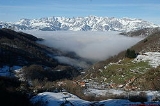
The Picos de Europa National Park is a National Park
in the Picos de Europa
mountain range, in northern Spain
. It is shared by the autonomous communities of Asturias
, Cantabria
and Castile and León
.
in the Pyrenees
. When it was created 22 July 1918 it covered the western part of today's national park, centered on the Lakes of Covadonga
.
The Parque Nacional de la Montaña de Covadonga
, as it then was called, had an area of 169.25 km². On May 30, 1995 the park was extended to include its current total area of 646.60 km².
On July 9, 2003 UNESCO
approved Biosphere Reserve
status for the National Park. Picos de Europa is one of several biosphere reserves in the Cantabrian Mountains
which are being integrated into a single super-reserve to be known as "Gran Cantábrica".
 The total area of the park is 646.60 km² and is shared by Castilla y León, Asturias
, and Cantabria
. The highest point of the park is in Torre de Cerredo
peak, 2,648 m AMSL and the lowest point is 75 m AMSL in the Deva River
, that is, a vertical drop of 2,573 m.
The geological features of the park show the effects of glacial erosion on the limestone
massif
s that form the Cantabrian Mountains.
The human population is about 1300. There are many protected animal species, like the Capercaillie, the Lammergeier (Gypaetus barbatus), the Cantabrian brown bear and the Iberian Wolf (Canis lupus signatus). The most representative animal of the Picos de Europa is the Pyrenean chamois (Rupicapra pyrenaica) or sarrio, or its more specific relative, the Cantabrian chamois (Rupicapra pyrenaica parva) or rebeco, of which there are many sculptures around the park, as well as the Spanish ibex (Capra pyrenaica).
National park
A national park is a reserve of natural, semi-natural, or developed land that a sovereign state declares or owns. Although individual nations designate their own national parks differently A national park is a reserve of natural, semi-natural, or developed land that a sovereign state declares or...
in the Picos de Europa
Picos de Europa
The Picos de Europa is a range of mountains 20 km inland from the northern coast of Spain, located in the Autonomous Communities of Asturias, Cantabria and Castile and León, forming part of the Cantabrian Mountains...
mountain range, in northern Spain
Spain
Spain , officially the Kingdom of Spain languages]] under the European Charter for Regional or Minority Languages. In each of these, Spain's official name is as follows:;;;;;;), is a country and member state of the European Union located in southwestern Europe on the Iberian Peninsula...
. It is shared by the autonomous communities of Asturias
Asturias
The Principality of Asturias is an autonomous community of the Kingdom of Spain, coextensive with the former Kingdom of Asturias in the Middle Ages...
, Cantabria
Cantabria
Cantabria is a Spanish historical region and autonomous community with Santander as its capital city. It is bordered on the east by the Basque Autonomous Community , on the south by Castile and León , on the west by the Principality of Asturias, and on the north by the Cantabrian Sea.Cantabria...
and Castile and León
Castile and León
Castile and León is an autonomous community in north-western Spain. It was so constituted in 1983 and it comprises the historical regions of León and Old Castile...
.
History
It was the first of the National Parks of Spain along with Ordesa y Monte Perdido National ParkOrdesa y Monte Perdido National Park
Ordesa y Monte Perdido National Park is an IUCN Category II National Park situated in the Pyrenees of Huesca province, Aragon, Spain. There has been a National Park in the Ordesa Valley since 1918. Its protected area was enlarged in 1982 to cover the whole region amounting to 156.08 km².It has...
in the Pyrenees
Pyrenees
The Pyrenees is a range of mountains in southwest Europe that forms a natural border between France and Spain...
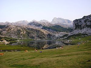
. When it was created 22 July 1918 it covered the western part of today's national park, centered on the Lakes of Covadonga
Lakes of Covadonga
The Lakes of Covadonga are of two glacial lakes located on the region of Asturias, Spain. These lakes, usually also called Lakes of Enol, are Lake Enol and Lake Ercina located in the Picos de Europa range and they are the original center of the Picos de Europa National Park, created in...
.
The Parque Nacional de la Montaña de Covadonga
Covadonga
Covadonga is a village and one of 11 parishes in Cangas de Onís, a municipality within the province and autonomous community of Asturias, in northwestern Spain...
, as it then was called, had an area of 169.25 km². On May 30, 1995 the park was extended to include its current total area of 646.60 km².
On July 9, 2003 UNESCO
UNESCO
The United Nations Educational, Scientific and Cultural Organization is a specialized agency of the United Nations...
approved Biosphere Reserve
Biosphere reserve
The Man and the Biosphere Programme of UNESCO was established in 1971 to promote interdisciplinary approaches to management, research and education in ecosystem conservation and sustainable use of natural resources.-Development:...
status for the National Park. Picos de Europa is one of several biosphere reserves in the Cantabrian Mountains
Cantabrian Mountains
The Cantabrian Mountains or Cantabrian Range are one of the main systems of mountain ranges in Spain.They extend for more than approximately 180 miles across northern Spain, from the western limit of the Pyrenees to the edges of the Galician Massif close to Galicia, along the coast of the...
which are being integrated into a single super-reserve to be known as "Gran Cantábrica".
Geography
Asturias
The Principality of Asturias is an autonomous community of the Kingdom of Spain, coextensive with the former Kingdom of Asturias in the Middle Ages...
, and Cantabria
Cantabria
Cantabria is a Spanish historical region and autonomous community with Santander as its capital city. It is bordered on the east by the Basque Autonomous Community , on the south by Castile and León , on the west by the Principality of Asturias, and on the north by the Cantabrian Sea.Cantabria...
. The highest point of the park is in Torre de Cerredo
Torre de Cerredo
Torrecerredo or Torre de Cerredo is a 2,648-metre-high peak, the highest one of the Picos de Europa and the Cantabrian Mountains. It is located on the central massif of the Picos de Europa, called Urrieles, on the limits of Asturias and the León provinces...
peak, 2,648 m AMSL and the lowest point is 75 m AMSL in the Deva River
Deva River
The Deva is a river in Northern Spain, flowing through the Autonomous Communities of Cantabria and Asturias until it joins the Cares River and flows into the Atlantic Ocean, in the Bay of Biscay, where they form the Tina Mayor estuary which is the natural border between Asturias and Cantabria....
, that is, a vertical drop of 2,573 m.
The geological features of the park show the effects of glacial erosion on the limestone
Limestone
Limestone is a sedimentary rock composed largely of the minerals calcite and aragonite, which are different crystal forms of calcium carbonate . Many limestones are composed from skeletal fragments of marine organisms such as coral or foraminifera....
massif
Massif
In geology, a massif is a section of a planet's crust that is demarcated by faults or flexures. In the movement of the crust, a massif tends to retain its internal structure while being displaced as a whole...
s that form the Cantabrian Mountains.
Flora and fauna
Several types of woods can be found in the area: trees include beeches and Cantabrian Holm Oaks.The human population is about 1300. There are many protected animal species, like the Capercaillie, the Lammergeier (Gypaetus barbatus), the Cantabrian brown bear and the Iberian Wolf (Canis lupus signatus). The most representative animal of the Picos de Europa is the Pyrenean chamois (Rupicapra pyrenaica) or sarrio, or its more specific relative, the Cantabrian chamois (Rupicapra pyrenaica parva) or rebeco, of which there are many sculptures around the park, as well as the Spanish ibex (Capra pyrenaica).
See also
- Picos de EuropaPicos de EuropaThe Picos de Europa is a range of mountains 20 km inland from the northern coast of Spain, located in the Autonomous Communities of Asturias, Cantabria and Castile and León, forming part of the Cantabrian Mountains...
- Cantabrian MountainsCantabrian MountainsThe Cantabrian Mountains or Cantabrian Range are one of the main systems of mountain ranges in Spain.They extend for more than approximately 180 miles across northern Spain, from the western limit of the Pyrenees to the edges of the Galician Massif close to Galicia, along the coast of the...
- Redes Natural ParkRedes Natural ParkThe Redes Natural Park is located in the Principality of Asturias in northern Spain. Its total area is , split between two municipalities: Caso and Sobrescobio . It was declared a natural park in 1996.-Conservation:...
- San GlorioSan GlorioSan Glorio is a mountain pass in the Cantabrian Mountains of Northern Spain. The pass reaches an altitude of 1609 metres along the national highway N621 which connects the city of León with Cantabria and which passes through Asturias....