

Phetchaburi Province
Encyclopedia
Phetchaburi is one of the central provinces
(changwat) of Thailand
. Neighboring provinces are (from north clockwise) Ratchaburi
, Samut Songkhram
and Prachuap Khiri Khan
. In the west it borders Tanintharyi Division
of Myanmar
.
, with the Gulf of Thailand
to the East and the Tanaosi mountain range forming the boundary to Myanmar. Except these border mountains most of the province is a flat plain area. With an area of about 3000 km² the Kaeng Krachan National Park
is Thailands largest national park, covering nearly half of the province. It protects mostly rainforests in the mountains along the boundary to Myanmar, but also the Kaeng Krachan reservoir is part of the park. The only significant river of the province is the Phetchaburi River
.
Several caves are found in the province, most notable the Khao Luang caves near the capital city. Illuminated by a hole in the roof several Buddha statues are placed in the cave.
 Phetchaburi is an old royal city, dating back to the Mon of the 8th century. Later Khmer
settled in the city, as can be seen by the prang
s of Wat Kamphaeng Laeng.
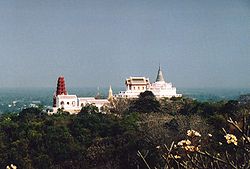
Im 1860 King Rama IV built a palace near the city of Phetchaburi, commonly known as Khao Wang, but its official name is Phra Nakhon Khiri
. Next to the palace the king built a tower for his astronomical observations. On the adjoining hill is the royal temple Wat Phra Kaeo.
shows the Khao Wang palace in the background. In front are rice fields bordered by two coconut palm trees, symbolizing the major crops in the province.
Provincial tree is Eugenia cumini.
 The province is subdivided into 8 districts (amphoe
), which are further subdivided into 93 communes (tambon
) and 681 villages (muban
).
Appearing to have been frozen in time warp, midway between remaining a Thai-style resort, and modernising to meet international tastes and requirements, this extensive pine-fringed beach is considered to be one of the most popular beaches of Thailand.
Maruekhathaiyawan Palace (พระราชนิเวศน์มฤคทายวัน)
This beachside wooden palace was formerly used as a royal summer residence by King Rama VI during the 1920s. Facing the open sea, the palace is referred to as the palace of love and hope”.
Huai Sai Wildlife Breeding Centre (ศูนย์เพาะเลี้ยงและขยายพันธุ์สัตว์ป่าห้วยทราย)
14 kilometres south of Cha-am at km. 220, a 4-kilometre branch road leads to the Huai Sai Wildlife Breeding Centre where wild animals, both mammals and birds, are conserved in its shady area.
Phra Nakhon Khiri Historical Park (อุทยานประวัติศาสตร์พระนครคีรี)
This covers a hilly area with an old palace and historical temples in the vicinity of the town. It consists of royal halls, temples and groups of buildings, constructed mostly in harmonious Thai, Western neoclassic and Chinese architectural styles.
Khao Bandai It (เขาบันไดอิฐ)
This hill is 121 metres high and just 2 kilometres south of Khao Wang. It is the site of an ancient temple of the Ayutthaya Period. There are several caves called Tham Prathun, Tham Phra Chao Suea, and Tham Phra Phuttha Saiyat.
Tham Khao Luang (ถ้ำเขาหลวง)
This cave houses a Buddha image cast by the royal command of King Rama V as a dedication to King Rama III and King Rama IV. At the foot of the Khao Luang Hill, there is a large monastery called "Wat Tham Klaep" or Wat Bun-thawi which has a very large hall and a chapel with beautifully carved door panels.
Wat Mahathat Worawihan (วัดมหาธาตุวรวิหาร)
There is a five-topped pagoda constructed in accordance with the Mahayana concept housing Lord Buddha’s relics. The stucco designs decorated on the viharn and the ubosot reflect the excellent skill of local craftsmen.
Wat Yai Suwannaram (วัดใหญ่สุวรรณาราม)
The main shrine hall has no windows. It contains 300-year-old mural paintings of mythical angels. The hall also houses a preaching throne with intricate woodcarvings and gold gilt works of Bangkok design.
Wat Kamphaeng Laeng (วัดกำแพงแลง)
This temple was originally a Khmer place of worship. It was later turned into a Buddhist temple and a shrine hall was constructed. However, the outlook of the place has not much changed due to the existence of sandstone walls and four Khmer style pagodas.
Phra Ram Ratchaniwet (พระรามราชนิเวศน์)
This palace of European architectural style is originally called "Wang Ban Puen". King Rama V commanded it built as a rainy season palace in 1916. It was used to welcome and accommodate state visitors during the reign of King Rama VI.
Hat Chao Samran (หาดเจ้าสำราญ)
Legend says that King Naresuan the Great and King Eka Thotsarot made several royal visits here and highly appreciated its beauty. The villagers thus rendered it a name "Hat Chao Samran", which means “Beach of Royal Leisure”.
Hat Puek Tian (หาดปึกเตียน)
This wide and long beach is popular among Thai tourists. The most prominent landmark is a huge statue of a female giant standing in the sea.
Wat Khao Takhrao (วัดเขาตะเครา)
This temple houses a highly revered sitting Buddha image called "Luang Pho Khao Takhrao". The image was found at the mouth of the Mae Klong River in Samut Songkhram by the villagers of Ban Laem, who migrated from Ban Laem to Samut Songkhram during the fall of Ayutthaya.
Hat Laem Luang (หาดแหลมหลวง)
Located 4 kilometres north of Hat Chao Samran, this beach stretchs for 2 kilometres and is full of white sand.
Kaeng Krachan Dam (เขื่อนแก่งกระจาน)
It is 760 metres long and 58 metres high, overlooking beautiful scenery of the reservoir and its islands.
Kaeng Krachan National Park (อุทยานแห่งชาติแก่งกระจาน)
This is the most extensive national park of Thailand and still largely unexplored. It was declared a national park on June 12, 1981, with clearly defined areas for a reservoir and year round green jungle in the Tanaosri Ranges, which are the origins of many rivers.
Tham Khao Yoi (ถ้ำเขาย้อย)
It houses several Buddha images and was the place where King Mongkut practised meditation while he was in the monkhood.
Wat Kuti (วัดกุฏิ)
This temple houses a Bot or rite hall made entirely from carved teak wood. Its outer surface of the walls was carved into scenes depicting Lord Buddha’s story and the door panels into openwork of intwined spray patterns, all with masterly craftsmanship.
Lao Song or Thai Song Dam Tribal Villages (หมู่บ้านลาวโซ่งหรือไทยทรงดำ)
These are found in many types of vicinity in Amphoe Khao Yoi, particularly at Ban Nong Prong and Ban Thap Khang. Their ancestors have migrated from Laos. In April, they organise their own social events with entertainment and folk plays.
Phra Nakhon Khiri, also known as Khao Wang, is an important historical site. During the reign of King Rama IV, it served as the king’s out-of-town palace.
To celebrate Phetchaburi’s cultural heritage-particular Phra Nakhon Khiri-the people of Phetchaburi hold the Phra Nakhon Khiri Fair regularly around the end of February at Khao Wang Compound.
The five-day fair presents a parade of people enacting the procession of monarchs who ruled Phetchaburi; during the Dvaravati and Srivijaya Periods. Apart from that, there are exhibitions on Phetchaburi’s history and archaeological objects. Cooking demonstrations on the province’s famous dishes and sweetmeats are among the main attractions of the fair. Also featured are various kinds of entertainment and contests.
Thai Song Dam Festival (ประเพณีไทยทรงดำ)
The festival is held annually on April 18 at Song Dam Village, Khao Yoi district. Apart from a merit-making ceremony, folk plays and the authentic cuisine of Thai Song Dam villagers are also on offer. Many villagers wear their traditional costumes
Provinces of Thailand
Thailand is divided into 76 provinces , which are geographically grouped into 6 regions. The capital Bangkok is not a province but a special administrative area and is included as the 77th province since it is administered at the same level as the other 76 provinces. The name of the provinces are...
(changwat) of Thailand
Thailand
Thailand , officially the Kingdom of Thailand , formerly known as Siam , is a country located at the centre of the Indochina peninsula and Southeast Asia. It is bordered to the north by Burma and Laos, to the east by Laos and Cambodia, to the south by the Gulf of Thailand and Malaysia, and to the...
. Neighboring provinces are (from north clockwise) Ratchaburi
Ratchaburi Province
Ratchaburi is one of the central provinces of Thailand. Neighboring provinces are Kanchanaburi, Nakhon Pathom,Samut Sakhon, Samut Songkhram and Phetchaburi...
, Samut Songkhram
Samut Songkhram Province
Samut Songkhram ) is one of the central provinces of Thailand.Neighboring provinces are Phetchaburi, Ratchaburi and Samut Sakhon. Local people call Samut Songkhram Mae Klong. The province is the smallest of all Thai provinces areawise...
and Prachuap Khiri Khan
Prachuap Khiri Khan Province
Prachuap Khiri Khan is one of the central provinces of Thailand. Neighboring provinces are Phetchaburi in the north and Chumphon in the south. To the west it borders Tanintharyi Division of Myanmar....
. In the west it borders Tanintharyi Division
Tanintharyi Division
Tanintharyi Region , is an administrative region of Myanmar, covering the long narrow southern part of the country on the Kra Isthmus. It borders with the Andaman Sea to the west and with the Tenasserim Hills, beyond which lies Thailand, to the east. To the north is the Mon State. The capital of...
of Myanmar
Myanmar
Burma , officially the Republic of the Union of Myanmar , is a country in Southeast Asia. Burma is bordered by China on the northeast, Laos on the east, Thailand on the southeast, Bangladesh on the west, India on the northwest, the Bay of Bengal to the southwest, and the Andaman Sea on the south....
.
Geography
Phetchaburi is located at the northern end of the Malay PeninsulaMalay Peninsula
The Malay Peninsula or Thai-Malay Peninsula is a peninsula in Southeast Asia. The land mass runs approximately north-south and, at its terminus, is the southern-most point of the Asian mainland...
, with the Gulf of Thailand
Gulf of Thailand
The Gulf of Thailand , also known in to Malays as Teluk Siam literally meant Gulf of Siam, is a shallow arm of the South China Sea.-Geography:...
to the East and the Tanaosi mountain range forming the boundary to Myanmar. Except these border mountains most of the province is a flat plain area. With an area of about 3000 km² the Kaeng Krachan National Park
Kaeng Krachan National Park
Kaeng Krachan is the largest national park of Thailand, located at the northern end of the Malay Peninsula. Due to its location near the tourist town of Hua Hin it is a popular park.-Geography:...
is Thailands largest national park, covering nearly half of the province. It protects mostly rainforests in the mountains along the boundary to Myanmar, but also the Kaeng Krachan reservoir is part of the park. The only significant river of the province is the Phetchaburi River
Phetchaburi River
The Phetchaburi River is a river in western Thailand. It originates in Kaeng Krachan National Park, Kaeng Krachan district and flows through Tha Yang, Ban Lat, Mueang Phetchaburi and mouths into the Bay of Bangkok in Ban Laem district. It is 210 km long, most of which is within the...
.
Several caves are found in the province, most notable the Khao Luang caves near the capital city. Illuminated by a hole in the roof several Buddha statues are placed in the cave.
History
Khmer Empire
The Khmer Empire was one of the most powerful empires in Southeast Asia. The empire, which grew out of the former kingdom of Chenla, at times ruled over and/or vassalized parts of modern-day Laos, Thailand, Vietnam, Burma, and Malaysia. Its greatest legacy is Angkor, the site of the capital city...
settled in the city, as can be seen by the prang
Stupa
A stupa is a mound-like structure containing Buddhist relics, typically the remains of Buddha, used by Buddhists as a place of worship....
s of Wat Kamphaeng Laeng.
Im 1860 King Rama IV built a palace near the city of Phetchaburi, commonly known as Khao Wang, but its official name is Phra Nakhon Khiri
Phra Nakhon Khiri historical park
Phra Nakhon Khiri is a historical park in Phetchaburi, Thailand, located on a hill overlooking the city. The name Phra Nakhon Khiri means Holy City Hill, but locals know it better as Khao Wang, meaning hill with palace.The park consists of three building groups, located on the three peaks of the...
. Next to the palace the king built a tower for his astronomical observations. On the adjoining hill is the royal temple Wat Phra Kaeo.
Symbols
The provincial sealSeals of The Provinces of Thailand
-Present-day provinces of Thailand:This list includes all the seals of the Provinces of Thailand. It also includes the special administrative area of the capital, Bangkok.-Former Provinces:-External links:*...
shows the Khao Wang palace in the background. In front are rice fields bordered by two coconut palm trees, symbolizing the major crops in the province.
Provincial tree is Eugenia cumini.
Administrative divisions
Amphoe
An amphoe is the second level administrative subdivision of Thailand. Usually translated as district, amphoe make up the provinces, and are analogous to a county seat...
), which are further subdivided into 93 communes (tambon
Tambon
Tambon is a local government unit in Thailand. Below district and province , they form the third administrative subdivision level. As of the 2009 there are 7255 tambon, not including the 169 khwaeng of Bangkok, which are set at the same administrative level, thus every district contains 8-10 tambon...
) and 681 villages (muban
Muban
Muban is the lowest administrative subdivision of Thailand. Usually translated as village, they are the subdivision of tambon. As of 2008, there are 74944 administrative villages in Thailand. As of the 1990 census, the average village consisted of 144 households or 746 persons.A muban does not...
).
|
|
Sights
Hat Cha-am (หาดชะอำ)Appearing to have been frozen in time warp, midway between remaining a Thai-style resort, and modernising to meet international tastes and requirements, this extensive pine-fringed beach is considered to be one of the most popular beaches of Thailand.
Maruekhathaiyawan Palace (พระราชนิเวศน์มฤคทายวัน)
This beachside wooden palace was formerly used as a royal summer residence by King Rama VI during the 1920s. Facing the open sea, the palace is referred to as the palace of love and hope”.
Huai Sai Wildlife Breeding Centre (ศูนย์เพาะเลี้ยงและขยายพันธุ์สัตว์ป่าห้วยทราย)
14 kilometres south of Cha-am at km. 220, a 4-kilometre branch road leads to the Huai Sai Wildlife Breeding Centre where wild animals, both mammals and birds, are conserved in its shady area.
Phra Nakhon Khiri Historical Park (อุทยานประวัติศาสตร์พระนครคีรี)
This covers a hilly area with an old palace and historical temples in the vicinity of the town. It consists of royal halls, temples and groups of buildings, constructed mostly in harmonious Thai, Western neoclassic and Chinese architectural styles.
Khao Bandai It (เขาบันไดอิฐ)
This hill is 121 metres high and just 2 kilometres south of Khao Wang. It is the site of an ancient temple of the Ayutthaya Period. There are several caves called Tham Prathun, Tham Phra Chao Suea, and Tham Phra Phuttha Saiyat.
Tham Khao Luang (ถ้ำเขาหลวง)
This cave houses a Buddha image cast by the royal command of King Rama V as a dedication to King Rama III and King Rama IV. At the foot of the Khao Luang Hill, there is a large monastery called "Wat Tham Klaep" or Wat Bun-thawi which has a very large hall and a chapel with beautifully carved door panels.
Wat Mahathat Worawihan (วัดมหาธาตุวรวิหาร)
There is a five-topped pagoda constructed in accordance with the Mahayana concept housing Lord Buddha’s relics. The stucco designs decorated on the viharn and the ubosot reflect the excellent skill of local craftsmen.
Wat Yai Suwannaram (วัดใหญ่สุวรรณาราม)
The main shrine hall has no windows. It contains 300-year-old mural paintings of mythical angels. The hall also houses a preaching throne with intricate woodcarvings and gold gilt works of Bangkok design.
Wat Kamphaeng Laeng (วัดกำแพงแลง)
This temple was originally a Khmer place of worship. It was later turned into a Buddhist temple and a shrine hall was constructed. However, the outlook of the place has not much changed due to the existence of sandstone walls and four Khmer style pagodas.
Phra Ram Ratchaniwet (พระรามราชนิเวศน์)
This palace of European architectural style is originally called "Wang Ban Puen". King Rama V commanded it built as a rainy season palace in 1916. It was used to welcome and accommodate state visitors during the reign of King Rama VI.
Hat Chao Samran (หาดเจ้าสำราญ)
Legend says that King Naresuan the Great and King Eka Thotsarot made several royal visits here and highly appreciated its beauty. The villagers thus rendered it a name "Hat Chao Samran", which means “Beach of Royal Leisure”.
Hat Puek Tian (หาดปึกเตียน)
This wide and long beach is popular among Thai tourists. The most prominent landmark is a huge statue of a female giant standing in the sea.
Wat Khao Takhrao (วัดเขาตะเครา)
This temple houses a highly revered sitting Buddha image called "Luang Pho Khao Takhrao". The image was found at the mouth of the Mae Klong River in Samut Songkhram by the villagers of Ban Laem, who migrated from Ban Laem to Samut Songkhram during the fall of Ayutthaya.
Hat Laem Luang (หาดแหลมหลวง)
Located 4 kilometres north of Hat Chao Samran, this beach stretchs for 2 kilometres and is full of white sand.
Kaeng Krachan Dam (เขื่อนแก่งกระจาน)
It is 760 metres long and 58 metres high, overlooking beautiful scenery of the reservoir and its islands.
Kaeng Krachan National Park (อุทยานแห่งชาติแก่งกระจาน)
This is the most extensive national park of Thailand and still largely unexplored. It was declared a national park on June 12, 1981, with clearly defined areas for a reservoir and year round green jungle in the Tanaosri Ranges, which are the origins of many rivers.
Tham Khao Yoi (ถ้ำเขาย้อย)
It houses several Buddha images and was the place where King Mongkut practised meditation while he was in the monkhood.
Wat Kuti (วัดกุฏิ)
This temple houses a Bot or rite hall made entirely from carved teak wood. Its outer surface of the walls was carved into scenes depicting Lord Buddha’s story and the door panels into openwork of intwined spray patterns, all with masterly craftsmanship.
Lao Song or Thai Song Dam Tribal Villages (หมู่บ้านลาวโซ่งหรือไทยทรงดำ)
These are found in many types of vicinity in Amphoe Khao Yoi, particularly at Ban Nong Prong and Ban Thap Khang. Their ancestors have migrated from Laos. In April, they organise their own social events with entertainment and folk plays.
Activities
Rafting along the Phetchaburi River (ล่องแก่งแม่น้ำเพชรบุรี) is an exciting adventure through the Kaeng Krachan National Park. The trip from Phetchaburi to the starting point takes 3 hours by 4-wheel drive truck and the raft trip takes some 5 hours passing a verdant forest and a Karen hilltribe village.Local Products
Phetchaburi is famous for a vast variety of sweets. The reputation of these sweets stems from the use of Tanot (palm) sugar as some of their ingredients. Examples are Mo-kaeng, a sweet made from flour, sugar and eggs; A-lua and Sampanni, a sweet made from flour and sugar; Thong Yip, Thong Yot and Foi Thong, sweets made from baked egg-yolk; and Chao Tan Chueam (palm seed in thick syrup). Khao Chae (rice served with ice and sweetened meat) is a renowned local dish and is popular during the summer season as it cools you down. Khanomchin Thotman (rice noodles with fishcakes) is also a popular dish. Fruits are found in every season. Phetchaburi’s famous fruits are sweet and aromatic rose apples known as Chomphu Phet, fresh palm seeds, pineapples from Don Khun Huai, cantaloupes and gold bananas from Amphoe Tha Yang.Festivals
Phra Nakhon Khiri Fair (งานพระนครคีรี)Phra Nakhon Khiri, also known as Khao Wang, is an important historical site. During the reign of King Rama IV, it served as the king’s out-of-town palace.
To celebrate Phetchaburi’s cultural heritage-particular Phra Nakhon Khiri-the people of Phetchaburi hold the Phra Nakhon Khiri Fair regularly around the end of February at Khao Wang Compound.
The five-day fair presents a parade of people enacting the procession of monarchs who ruled Phetchaburi; during the Dvaravati and Srivijaya Periods. Apart from that, there are exhibitions on Phetchaburi’s history and archaeological objects. Cooking demonstrations on the province’s famous dishes and sweetmeats are among the main attractions of the fair. Also featured are various kinds of entertainment and contests.
Thai Song Dam Festival (ประเพณีไทยทรงดำ)
The festival is held annually on April 18 at Song Dam Village, Khao Yoi district. Apart from a merit-making ceremony, folk plays and the authentic cuisine of Thai Song Dam villagers are also on offer. Many villagers wear their traditional costumes