

Perdido pass
Encyclopedia

Perdido River
The Perdido River is a river in the U.S. states of Alabama and Florida. The river forms part of the boundary between the two states along nearly its entire length and drains into the Gulf of Mexico...
. Perdido Pass forms a water passage that connects Perdido Bay
Perdido Bay
Perdido Bay is a bay at the mouth of and draining the Perdido River, a designated Outstanding Florida Waters river, in Baldwin County, Alabama and Escambia County, Florida, United States.-Geography:...
with the Gulf of Mexico
Gulf of Mexico
The Gulf of Mexico is a partially landlocked ocean basin largely surrounded by the North American continent and the island of Cuba. It is bounded on the northeast, north and northwest by the Gulf Coast of the United States, on the southwest and south by Mexico, and on the southeast by Cuba. In...
to the south, in the U.S. state of Alabama
Alabama
Alabama is a state located in the southeastern region of the United States. It is bordered by Tennessee to the north, Georgia to the east, Florida and the Gulf of Mexico to the south, and Mississippi to the west. Alabama ranks 30th in total land area and ranks second in the size of its inland...
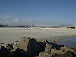
, 2 miles (3 km) west of the Alabama/Florida state line. A bridge spans Perdido Pass, connecting Alabama Point (western side) with Florida Point in Alabama (linked below). At the entrance into the Gulf, the 2 rock barriers, extending from the white beaches, are the west jetty & east jetty (see image). The surrounding area is heavily developed, with high-rise condominium
Condominium
A condominium, or condo, is the form of housing tenure and other real property where a specified part of a piece of real estate is individually owned while use of and access to common facilities in the piece such as hallways, heating system, elevators, exterior areas is executed under legal rights...
s. However, there are nearby beach-front parks, with Gulf State Park
Gulf State Park
Gulf State Park is a state park in Gulf Shores, Alabama in southern Baldwin County. The park property mostly covers the land behind the Gulf Shores beach community, between Highway 59 and SH 161, but the west end extends further south to a wide beach area along the Gulf of Mexico...
on the eastern side of Perdido Pass.
Description
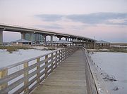
Perdido Pass, extending between Florida Point and Alabama Point, is easily distinguished, from offshore, by the Alabama State Route 182Alabama State Route 182
State Route 182 or SR-182 is a state highway that serves as the primary east-west connection along the Alabama shoreline of the Gulf of Mexico between Gulf Shores and Orange Beach in Baldwin County...
highway bridge in Orange Beach, Alabama
Orange Beach, Alabama
Orange Beach is a city in Baldwin County, Alabama, United States. At the 2000 census the population was 3,784. It is part of the Daphne–Fairhope–Foley Micropolitan Statistical Area.-Geography:...
, spanning the pass with two openings. The fixed span over Perdido Pass Channel has a clearance of 54 feet (16.5 m). The fixed span over Cotton Bayou Channel has a clearance of 41 feet (12.5 m). The dredged entrance channel leads from the Gulf through Perdido Pass to a fork at the highway bridge; thence into two channels, one leading north into Terry Cove and Johnson Cove and the other leading east into Bayou St. John. The entrance to the pass is protected by a jetty on the west and by a combination weir and jetty on the east; the top of the weir is submerged 6 inches (15.2 cm) at mean low tide. Numerous sunken wrecks are in the approach to the pass.
Depth of channels
Buoy
A buoy is a floating device that can have many different purposes. It can be anchored or allowed to drift. The word, of Old French or Middle Dutch origin, is now most commonly in UK English, although some orthoepists have traditionally prescribed the pronunciation...
off the entrance marks the approach.
Access to the Intracoastal Waterway
The Intracoastal WaterwayIntracoastal Waterway
The Intracoastal Waterway is a 3,000-mile waterway along the Atlantic and Gulf coasts of the United States. Some lengths consist of natural inlets, salt-water rivers, bays, and sounds; others are artificial canals...
, in the lower part of Perdido Bay, is reached from Perdido Pass via a marked channel through Bayou St. John. In May 1982, shoaling to 6 feet (1.8 m) was reported in Bayou St. John, between day-beacons no. 6 and 8. An overhead power cable, with a clearance of 59 ft (18 m), crosses the channel leading to Terry Cove and Johnson Cove, about 0.4 mile (0.643736 km) from the State Route 182 fixed bridge. Several small-craft facilities are in the coves and Cotton Bayou, on the W side of Perdido Pass 0.7 miles (1.1 km) above the entrance.
Old River
Old River enters Perdido Pass from the east between Florida Point and Ono Island
Ono Island (Alabama)
Ono Island is a long barrier island in southern Baldwin County, Alabama, at the mouth of Perdido Bay on the northern Gulf of Mexico. It is bordered by Bayou St. John to the north and Old River to the south. Surrounding communities include Perdido Key, Florida to the south and east and Orange...
. In May 1982, a reported depth of 5 feet (1.5 m) could be carried through the river, with local knowledge. The Florida
Florida
Florida is a state in the southeastern United States, located on the nation's Atlantic and Gulf coasts. It is bordered to the west by the Gulf of Mexico, to the north by Alabama and Georgia and to the east by the Atlantic Ocean. With a population of 18,801,310 as measured by the 2010 census, it...
-Alabama state boundary passes along the center of Old River until 2 miles (3 km) before Perdido Pass. A fixed highway bridge with a clearance of 24 feet (7.3 m) crosses Old River, about 1 miles (1.6 km) east of Perdido Pass.
Florida Point in Alabama
Both Alabama Point and Florida Point are in the town of Orange Beach, AlabamaOrange Beach, Alabama
Orange Beach is a city in Baldwin County, Alabama, United States. At the 2000 census the population was 3,784. It is part of the Daphne–Fairhope–Foley Micropolitan Statistical Area.-Geography:...
(along the Gulf of Mexico). However, Florida Point is the tip of a peninsula originating in the U.S. State of Florida
Florida
Florida is a state in the southeastern United States, located on the nation's Atlantic and Gulf coasts. It is bordered to the west by the Gulf of Mexico, to the north by Alabama and Georgia and to the east by the Atlantic Ocean. With a population of 18,801,310 as measured by the 2010 census, it...
, with the final 2 miles (3 km) of the tip contained within Alabama. Often U.S. state lines run through the middle of a water pass or river; however, the Perido Pass is entirely within the State of Alabama, where the state line runs east of it. The Gulf State Park
Gulf State Park
Gulf State Park is a state park in Gulf Shores, Alabama in southern Baldwin County. The park property mostly covers the land behind the Gulf Shores beach community, between Highway 59 and SH 161, but the west end extends further south to a wide beach area along the Gulf of Mexico...
is located on Florida Point. Historically, new passes are breached and old ones filled in during hurricanes.The original pass discovered by Juan Carlos Siquenza(sp?)was located on the current state boundary between Alabama, and Florida. The use of stone and cement jettys combined with dredging and pumping sand out of the pass by the Army Corps of Engineers and the City of Orange Beach currently mitigates damage from hurricanes and sedimentation.
2010 Gulf oil spill
Following the Deepwater Horizon oil spillDeepwater Horizon oil spill
The Deepwater Horizon oil spill is an oil spill in the Gulf of Mexico which flowed unabated for three months in 2010, and continues to leak fresh oil. It is the largest accidental marine oil spill in the history of the petroleum industry...
(called the "Gulf oil spill"), the entrance to Perdido Pass was closed, with a barrier system in June 2010, to control tidal flow of oil entering from the Gulf of Mexico. The daily high tide
High Tide
High Tide was a band formed in 1969 by Tony Hill , Simon House , Peter Pavli and Roger Hadden .-History:...
was causing oil-contaminated water to enter Perdido Bay
Perdido Bay
Perdido Bay is a bay at the mouth of and draining the Perdido River, a designated Outstanding Florida Waters river, in Baldwin County, Alabama and Escambia County, Florida, United States.-Geography:...
. The barrier system was designed to allow boats to travel through Perdido Pass, during the outflowing tide, but close during the rising tide and collect oil deposits in a retention area on the eastern edge of the pass. During the disaster BP took over much of the Gulf State Park
Gulf State Park
Gulf State Park is a state park in Gulf Shores, Alabama in southern Baldwin County. The park property mostly covers the land behind the Gulf Shores beach community, between Highway 59 and SH 161, but the west end extends further south to a wide beach area along the Gulf of Mexico...
and used it for parking or storage of equipment.As of April 2011, BP
BP
BP p.l.c. is a global oil and gas company headquartered in London, United Kingdom. It is the third-largest energy company and fourth-largest company in the world measured by revenues and one of the six oil and gas "supermajors"...
or BP subcontractors were still utilizing the park free of charge.
East of Mobile Bay
Mobile Bay
Mobile Bay is an inlet of the Gulf of Mexico, lying within the state of Alabama in the United States. Its mouth is formed by the Fort Morgan Peninsula on the eastern side and Dauphin Island, a barrier island on the western side. The Mobile River and Tensaw River empty into the northern end of the...
the damage to the fragile environment from BP
BP
BP p.l.c. is a global oil and gas company headquartered in London, United Kingdom. It is the third-largest energy company and fourth-largest company in the world measured by revenues and one of the six oil and gas "supermajors"...
oil spill clean-up crews exceeded damage done by the oil spill itself.