
Pennsylvania Route 31
Encyclopedia
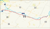
Pennsylvania Route 31 is a 74 miles (119.1 km) long state highway
located in Western Pennsylvania
, paralleling U.S. Route 30 and the Pennsylvania Turnpike
for most of its length. The designation begins at PA 136 near West Newton and ends at US 30 near Bedford.
near West Newton. It travels east, interchanging with Interstate 70. After that interchange, PA 31 does not intersect any more numbered roads
until it interchanges U.S. Route 119
in the western part of Mount Pleasant. When PA 31 interchanges US 119, it turns from a two-lane surface road into first a four-lane road, and then into a city street as it goes through Mount Pleasant.
As PA 31 progresses through Mount Pleasant, it forms a concurrency
with Pennsylvania Route 981
. After that, it intersects Pennsylvania Route 819
before leaving the borough and entering the township.
. This is the only major intersection until it reaches Donegal. When it does reach Donegal, there is an entrance ramp to the Pennsylvania Turnpike
, and immediately following that is the western terminus of the concurrency with Pennsylvania Route 711
.
2 miles (3 km) later, PA 31 intersects Pennsylvania Route 381
. This marks the eastern terminus of the concurrency with PA 711, and the western terminus of PA 381. It is also the northern terminus of the PA 381/711 concurrency as well. Before leaving Donegal Township, PA 31 approaches the eastern terminus of the concurrency with PA 381. This is the last major intersection before PA 31 winds its way through rural Pennsylvania to Somerset.
 After winding past rural Westmoreland and Fayette Counties, PA 31 enters Somerset County and encounters the borough of Somerset. Immediately after entering Somerset, PA 31 intersects Pennsylvania Route 281
and forms a concurrency on one-way pair
s. While being concurrent, both highways intersect the southern terminus of Pennsylvania Route 601
. Not a long while after, PA 31/281 end the concurrency, as PA 281 splits north, while PA 31 continues east.
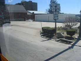
 Past the downtown area, PA 31 weaves through the Pennsylvania Turnpike
and passes over U.S. Route 219
. PA 31 continues toward Roxbury.
is the last intersection in Somerset County and the only one in Roxbury. After this intersection, PA 31 generally parallels the Turnpike and winds through hilly terrain.
and is concurrent for 1.81 mi (2.91 km). After separating, PA 31 continues for 3.44 mi (5.54 km) before terminating at U.S. Route 30
.
stations. The road would become PA 31 and would go through the towns of West Newton, Mount Pleasant, Monongahela
, and Washington
that had also organized underground railroad stations.
near Avella
, was concurrent
with PA 18 and US 19, and traded paths with US 40 in Washington
. The stretch from the West Virginia line to PA 18 is now PA 844.
. Since 1842, the inn was a place for weary travelers to unhitch their horses for a good place to eat and sleep. The modern day visitors of the inn use it for different reasons of traveling. The inn is located in the Laurel Mountains
recreational area.
State highway
State highway, state road or state route can refer to one of three related concepts, two of them related to a state or provincial government in a country that is divided into states or provinces :#A...
located in Western Pennsylvania
Western Pennsylvania
Western Pennsylvania consists of the western third of the state of Pennsylvania in the United States. Pittsburgh is the largest city in the region, with a metropolitan area population of about 2.4 million people, and serves as its economic and cultural center. Erie, Altoona, and Johnstown are its...
, paralleling U.S. Route 30 and the Pennsylvania Turnpike
Pennsylvania Turnpike
The Pennsylvania Turnpike is a toll highway system operated by the Pennsylvania Turnpike Commission in the Commonwealth of Pennsylvania, United States. The three sections of the turnpike system total . The main section extends from Ohio to New Jersey and is long...
for most of its length. The designation begins at PA 136 near West Newton and ends at US 30 near Bedford.
West Newton to Mount Pleasant
PA 31's designation begins at Pennsylvania Route 136Pennsylvania Route 136
Pennsylvania Route 136 is a long state highway located in Washington, Allegheny, and Westmoreland counties in Pennsylvania. The western terminus is at US 40 & PA 18 in Washington...
near West Newton. It travels east, interchanging with Interstate 70. After that interchange, PA 31 does not intersect any more numbered roads
State highway
State highway, state road or state route can refer to one of three related concepts, two of them related to a state or provincial government in a country that is divided into states or provinces :#A...
until it interchanges U.S. Route 119
U.S. Route 119
U.S. Route 119, commonly abbreviated as US 119, is a spur of US 19. It is a north–south route that was an original United States highway of 1926. It is often referred to as Corridor G east of US 23 and KY 80 in Kentucky to Interstate 64 at Charleston, West Virginia.- Kentucky :US 119 is a two...
in the western part of Mount Pleasant. When PA 31 interchanges US 119, it turns from a two-lane surface road into first a four-lane road, and then into a city street as it goes through Mount Pleasant.
As PA 31 progresses through Mount Pleasant, it forms a concurrency
Concurrency (road)
A concurrency, overlap, or coincidence in a road network is an instance of one physical road bearing two or more different highway, motorway, or other route numbers...
with Pennsylvania Route 981
Pennsylvania Route 981
Pennsylvania Route 981 is a state highway which runs across Westmoreland County, in southwestern Pennsylvania. The highway begins at Pennsylvania Route 51 in Rostraver Township, Pennsylvania, and runs northward across Westmoreland County, passing through the towns of Mount Pleasant, Latrobe, and...
. After that, it intersects Pennsylvania Route 819
Pennsylvania Route 819
Pennsylvania Route 819 is a long state highway located in Fayette and Westmoreland counties in Pennsylvania, USA. The southern terminus is at PA 201 in Vanderbilt. The northern terminus is at PA 66 in Oklahoma.-Fayette County:...
before leaving the borough and entering the township.
Mount Pleasant to Donegal
The first intersection with a numbered road after entering the township is Pennsylvania Route 982Pennsylvania Route 982
Pennsylvania Route 982 is a state highway which runs 33 miles across Fayette and Westmoreland counties, in southwestern Pennsylvania. The highway begins at U.S. Route 119 in Moyer, Pennsylvania, and runs northward into Westmoreland County, passing through the towns of Youngstown, Latrobe, and Derry...
. This is the only major intersection until it reaches Donegal. When it does reach Donegal, there is an entrance ramp to the Pennsylvania Turnpike
Pennsylvania Turnpike
The Pennsylvania Turnpike is a toll highway system operated by the Pennsylvania Turnpike Commission in the Commonwealth of Pennsylvania, United States. The three sections of the turnpike system total . The main section extends from Ohio to New Jersey and is long...
, and immediately following that is the western terminus of the concurrency with Pennsylvania Route 711
Pennsylvania Route 711
Pennsylvania Route 711 is an long, north–south state highway located in Fayette, Westmoreland and Indiana counties in Pennsylvania. The southern terminus is at US 119/PA 201 in Connellsville. The northern terminus is at PA 403 in East Wheatfield Township.-Route description:PA 711 goes by...
.
2 miles (3 km) later, PA 31 intersects Pennsylvania Route 381
Pennsylvania Route 381
Pennsylvania Route 381 is an long state highway located in Fayette, and Westmoreland counties in Pennsylvania. The southern terminus is the West Virginia state line near Elliottsville, where it continues as Preston County Route 8 to its southern terminus at WV 26 in Brandonville, WV...
. This marks the eastern terminus of the concurrency with PA 711, and the western terminus of PA 381. It is also the northern terminus of the PA 381/711 concurrency as well. Before leaving Donegal Township, PA 31 approaches the eastern terminus of the concurrency with PA 381. This is the last major intersection before PA 31 winds its way through rural Pennsylvania to Somerset.
Somerset County
Somerset
Pennsylvania Route 281
Pennsylvania Route 281 is an long state highway located in Fayette and Somerset counties in Pennsylvania. The southern terminus is the West Virginia state line near Markleysburg...
and forms a concurrency on one-way pair
One-way pair
A one-way pair, one-way couple, or just couplet is a pair of parallel, usually one-way streets that carry opposite directions of a signed route or major traffic flow, or sometimes opposite directions of a bus or streetcar route....
s. While being concurrent, both highways intersect the southern terminus of Pennsylvania Route 601
Pennsylvania Route 601
Pennsylvania Route 601 is an long state highway located in Somerset county in Pennsylvania. The southern terminus is at PA 31/PA 281 in Somerset...
. Not a long while after, PA 31/281 end the concurrency, as PA 281 splits north, while PA 31 continues east.
Pennsylvania Turnpike
The Pennsylvania Turnpike is a toll highway system operated by the Pennsylvania Turnpike Commission in the Commonwealth of Pennsylvania, United States. The three sections of the turnpike system total . The main section extends from Ohio to New Jersey and is long...
and passes over U.S. Route 219
U.S. Route 219
U.S. Route 219 is a spur of U.S. Route 19. It runs for from West Seneca, New York at an interchange with Interstate 90, to Rich Creek, Virginia, intersecting at U.S. Route 460. U.S. 219 is found in New York, Pennsylvania, Maryland, West Virginia, and Virginia...
. PA 31 continues toward Roxbury.
Roxbury
The intersection with Pennsylvania Route 160Pennsylvania Route 160
Pennsylvania Route 160 is a north–south state route located in Western Pennsylvania. Its southern terminus is at the Mason-Dixon line south of Wellersburg, and its northern terminus is at West High Street in Ebensburg....
is the last intersection in Somerset County and the only one in Roxbury. After this intersection, PA 31 generally parallels the Turnpike and winds through hilly terrain.
Bedford County
Entering Bedford County, there are no major intersections with any numbered roads until PA 31 enters Manns Choice. Instead, it winds through hilly terrain that parallels the Turnpike.Manns Choice to Bedford
As PA 31 nears Manns Choice, it intersects Pennsylvania Route 96Pennsylvania Route 96
Pennsylvania Route 96 is a long state highway located in southwestern Pennsylvania. The southern terminus of the route is at the Mason-Dixon Line in Londonderry Township, where PA 96 continues to the south as Maryland Route 35...
and is concurrent for 1.81 mi (2.91 km). After separating, PA 31 continues for 3.44 mi (5.54 km) before terminating at U.S. Route 30
U.S. Route 30
U.S. Route 30 is an east–west main route of the system of United States Numbered Highways, with the highway traveling across the northern tier of the country. It is the third longest U.S. route, after U.S. Route 20 and U.S. Route 6. The western end of the highway is at Astoria, Oregon; the...
.
History
As early as 1772, a road called Glades Road had originally led from Somerset to Bedford, which were the places of two underground railroadUnderground Railroad
The Underground Railroad was an informal network of secret routes and safe houses used by 19th-century black slaves in the United States to escape to free states and Canada with the aid of abolitionists and allies who were sympathetic to their cause. The term is also applied to the abolitionists,...
stations. The road would become PA 31 and would go through the towns of West Newton, Mount Pleasant, Monongahela
Monongahela, Pennsylvania
Monongahela, colloquially called "Mon City," is a Third Class City in Washington County, Pennsylvania, United States and is part of the Pittsburgh Metro Area, located approximately south of the city proper. The population was 4,761 at the 2000 census...
, and Washington
Washington, Pennsylvania
Washington is a city in and the county seat of Washington County, Pennsylvania, United States, within the Pittsburgh Metro Area in the southwestern part of the state...
that had also organized underground railroad stations.
Sproul Road Bill
In 1911, the Sproul Road Bill defined Legislative Route 181 for the segment between Washington and West Newton, LR 186 between West Newton and Somerset, LR 364 between Somerset and Dividing Ridge, and LR 49 between Dividing Ridge and Bedford.1927-1940
The PA 31 designation began appearing on road maps and signage in 1927. At that time, the western terminus was at the West Virginia line at West Virginia Route 27. The east end back then was still at US 30, unchanged from today. On its way eastward, PA 31 met the southern terminus of PA 28Pennsylvania Route 28
Pennsylvania Route 28 is a major state highway which runs for 97 miles from Interstate 279 and Interstate 579 at the Interstate 279 Interchange in Pittsburgh to U.S. Route 219 in Brockway in the U.S. state of Pennsylvania. The expressway from Kittanning to Pittsburgh is called the Alexander H...
near Avella
Avella, Pennsylvania
Avella is an unincorporated community in Independence Township, Washington County, Pennsylvania, United States. It is located at 40.27° north & 80.45° west.- History :...
, was concurrent
Concurrency (road)
A concurrency, overlap, or coincidence in a road network is an instance of one physical road bearing two or more different highway, motorway, or other route numbers...
with PA 18 and US 19, and traded paths with US 40 in Washington
Washington, Pennsylvania
Washington is a city in and the county seat of Washington County, Pennsylvania, United States, within the Pittsburgh Metro Area in the southwestern part of the state...
. The stretch from the West Virginia line to PA 18 is now PA 844.
Major intersections
Glades Pike Inn
The Glades Pike Inn is a notable inn situated on the Glades Pike section of PA 31 in SomersetSomerset, Pennsylvania
-Demographics:As of the census of 2000, there were 6,762 people, 3,035 households, and 1,717 families residing in the borough. The population density was 2,466.0 people per square mile . There were 3,313 housing units at an average density of 1,208.2 per square mile...
. Since 1842, the inn was a place for weary travelers to unhitch their horses for a good place to eat and sleep. The modern day visitors of the inn use it for different reasons of traveling. The inn is located in the Laurel Mountains
Laurel Highlands
The Laurel Highlands is a region in southwestern Pennsylvania made up of Fayette County, Somerset County and Westmoreland County. It has a population of about 600,000 people....
recreational area.