
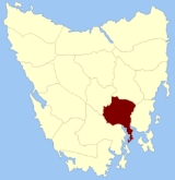
Monmouth Land District, Tasmania
Encyclopedia
Tasmania
Tasmania is an Australian island and state. It is south of the continent, separated by Bass Strait. The state includes the island of Tasmania—the 26th largest island in the world—and the surrounding islands. The state has a population of 507,626 , of whom almost half reside in the greater Hobart...
which are part of the Cadastral divisions of Tasmania
Cadastral divisions of Tasmania
The Lands administrative divisions of Tasmania refer to the division of Tasmania into land districts and parishes for cadastral purposes, which are part of the lands administrative divisions of Australia...
. It was formerly one of the 18 counties of Tasmania
Counties of Tasmania
The 18 former counties of Tasmania, renamed as Land Districts:*Arthur County*Buckingham County*Cornwall County*Cumberland County*Devon County*Dorset County*Franklin County*Glamorgan County*Kent County*Lincoln County*Monmouth County*Montagu County...
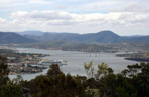
. It is bordered by the Derwent River
Derwent River (Tasmania)
The Derwent is a river in Tasmania, Australia. It was named after the River Derwent, Cumbria by British Commodore John Hayes who explored it in 1793. The name is Brythonic Celtic for "valley thick with oaks"....
to the south, the Clyde River
Clyde River
- Australia :*Clyde River , a river on the south coast of New South Wales*Clyde River , a river in central Tasmania*Clyde River , a river in the Northern Territory- United States of America :*Clyde River...
to the west, and a small part of the Jordan River to the north.
It includes the parts of Greater Hobart
Hobart
Hobart is the state capital and most populous city of the Australian island state of Tasmania. Founded in 1804 as a penal colony,Hobart is Australia's second oldest capital city after Sydney. In 2009, the city had a greater area population of approximately 212,019. A resident of Hobart is known as...
which are located to the east of the Derwent, such as Rosny Park
Rosny Park, Tasmania
Rosny Park is a suburb of Hobart, Tasmania, located in the City of Clarence on the eastern shore of the Derwent River. It is about five kilometres from the city centre of Hobart...
and Bridgewater
Bridgewater, Tasmania
Bridgewater, Tasmania, is one greater Hobart's northern-most suburbs, located 19 km from the city. It is situated on the eastern shore of the Derwent River. It is a suburb of the local government area of the Municipality of Brighton....
. It also includes Kempton
Kempton, Tasmania
Kempton is a township on the Midland Highway north of Hobart, Tasmania. At the 2006 census, the town had a population of 358. A low rainfall region of plains and low hills, it is mostly used for grazing sheep....
and Hamilton
Hamilton, Tasmania
Hamilton is a small rural town north west of Hobart in Tasmania on the Lyell Highway. At the 2006 census, the town and surrounding area had a population of 300....
.
The original parishes
On 15 January 1836 George Arthur, the Lieutenant Governor of the Island of Van Diemen's LandVan Diemen's Land
Van Diemen's Land was the original name used by most Europeans for the island of Tasmania, now part of Australia. The Dutch explorer Abel Tasman was the first European to land on the shores of Tasmania...
proclaimed, via The Hobart Town Courier
The Courier (Hobart)
The Courier is a newspaper founded in 1827 in Hobart, Tasmania, as the Hobart Town Courier. It changed names to the Hobart Town Courier and Van Diemen's Land Advertiser in 1839, settling on The Courier in 1840. In 1859 it merged with The Hobart Town Daily Mercury.-References:* from the Mercury...
, the first counties and parishes to be surveyed in the colony.
Eighth, The County of Monmouth, bounded on the north by Somersetshire; on the west by a portion of the Clyde to its junction with the Derwent, and thence on the south west by the Derwent to Storm bay; on the south by Storm bay and Frederick Henry bay; on the east by Pittwater and by the eastern boundaries of the parishes of Ulva, Staffa and Ormaig, and thence by a line to the junction of Beamont's rivulet with Little Swan port river. This county to include Betsey island and the Iron pot island.
Hundreds and parishes proclaimed at this time were:
- The hundred of Oatlands
- Bath parish
- York
- Newick
- Somerton
- The hundred of Westbury
- Westbury
- Quamby
- Sillwood
- Adelphi
- The hundred of Apsley
- Rutland
- Spring Hill
- Winterton
- Apsley
- The hundred of Picton
- Strangford
- Dysart
- Beaufort
- Huntingdon
- The hundred of Bothwell
- Vincent
- Largo
- Henry
- Grantham
- The hundred of Hamilton
- Hamilton
- Grafton
- Pelham
- Stradbroke
- The hundred of Pontville
- Wallace
- Lansdowne,
- Aldville
- Arundel
- The hundred of Brighton
- Lewis
- Staffa
- Ulva
- Drummond
- The hundred of Bellerive
- Forbes
- Cambridge
- Clarence
- Ralph's Bay
- The hundred of Yarlington
- Ormaig
- Yarlington
- unnamed
- unnamed